
Best in Travel
The 30 best countries, cities and regions to visit in 2025

See where a Lonely Planet Membership takes you
Plan your trip with Elsewhere, by Lonely Planet
Book with our partner, GetYourGuide

Subscribe to our weekly newsletters to get the latest travel news, expert advice, and insider recommendations
Articles by interest

Every month, we release new books into the wild

Explore the world with our detailed, insightful guidebooks

Stay ahead of the curve with our guidebooks

Uncover exciting new ways to explore iconic destinations

Download instantly and read any time
Jun 10, 2022 • 6 min read

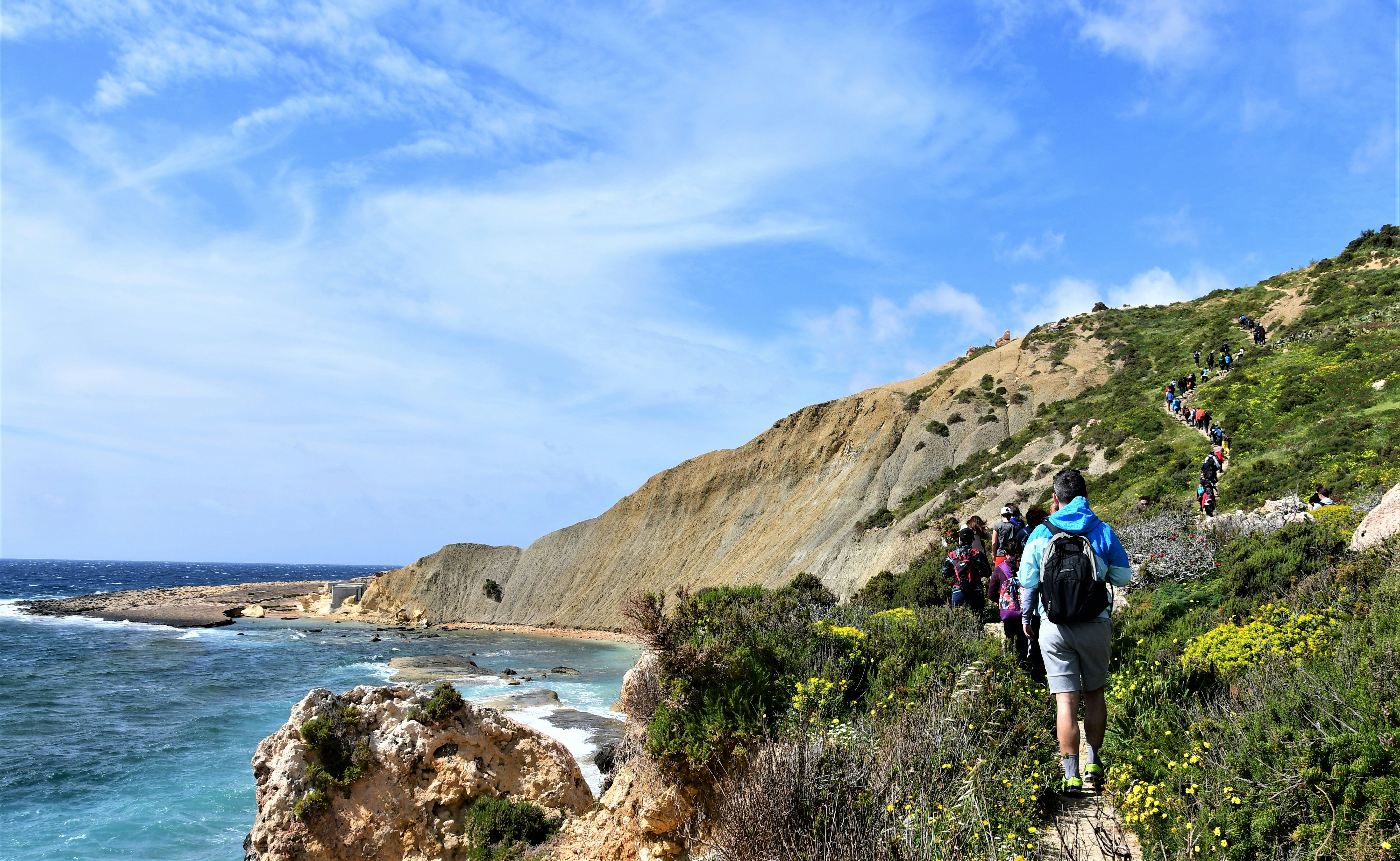
An informal collection of tracks, trails and historic limestone paths provides a brilliant overview of the Med’s smallest island nation © Felix Cesare / Getty Images
Malta may be a small country, but it packs in plenty of diversity for hikers. Moderate terrain, clifftop trails taking in coastal and Mediterranean views and the opportunity to hike amid centuries of history make it a versatile destination for active travelers.
And because the two main islands of Malta and Gozo are so compact, it’s easy to get an early start on a half-day walk, and then be on the beach or taking in the heritage architecture of Valletta or Mdina later in the afternoon.
160km (99 miles) round trip, 13 days, moderate
Circumnavigating the entirety of Malta’s coastline, this informal collection of tracks, trails and historic limestone paths provides a brilliant overview of the Med’s smallest island nation. Highlights include the glorious heritage townscapes of Valletta and the Three Cities, while clifftop walking trails give way to occasional diversions inland, through Maltese farmland and to Malta’s astounding collection of megalithic temples and prehistoric sites.
See Great Walks Malta for a map, trail notes and information on other recommended walks. Around five days are needed for the 50km (30-mile) Gozo Coastal Walk.
14.5km (9 miles) round trip, 4-5 hours, moderate
Looping clockwise around northern Malta’s Marfa peninsula, this hike begins and ends at Għadira Bay (also known as Mellieħa Bay). Begin at the Għadira Nature Reserve, an important wetlands area for migratory birds, before walking uphill to the Red Tower, one of a network of coastal watchtowers established by the Knights of St John. Follow the Marfa Ridge, high above sandy beaches and rocky coves, to the White Tower near the peninsula’s northeastern tip of Aħrax Point.
Traversing the northern fringes of Mellieħa Bay back via the Red Tower to Għadira, a highlight of the return hike is a blue and white statue of the Madonna at the Immaculate Conception Chapel.
6.7km (4.2 miles) one way, 2-3 hours, easy (excludes Delimara detour)
Joining two favorite southern Maltese destinations for seafood restaurants, this route begins by skirting Marsaskala’s St Thomas Bay, passing by the 17th-century defensive bastions of St Thomas Tower and Mamo Tower before heading inland through sunbaked farmland to the fishing port of Marsaxlokk. Sunday morning’s fish market attracts visitors from all across Malta, and the harbourfront restaurants are ideal for a leisurely lunch.
An optional there and back detour (3km/1.8mi) travels south down the Delimara peninsula from Tas-Silg Church near Marsaxlokk to Fort Delimara and a natural swimming pool at Il-Kalanka Bay.
7.7km (4.8 miles) one way, 2-3 hours, easy
Begin in the shaded Buskett Gardens, established by the Knights of St John as a hunting preserve and Malta’s last remaining woodland area, before continuing past "Clapham Junction," actually a collection of wheel ruts made by prehistoric carts. Extensive valley views then follow, incorporating bucolic Maltese farming landscapes and the Girgenti Palace, now the Maltese Prime Minister’s official residence.
This rural stroll ends in the village of Siggiewi. Three churches and several good pubs vie for the attention of Siggiewi locals, and there are regular buses back to Valletta.

11.2km (7 miles) one way, 3-4 hours, moderate
Starting near a giant golf-ball-like radar station atop Malta’s highest sea cliffs, this route travels down the country's west coast to finish at the tiny harbor at Wied iż-Żurrieq. Along the way, prehistoric history is showcased at the Bronze Age settlement of Wardija San Ġorġ and the megalithic temple complexes of Ħaġar Qim & Mnajdra, while clifftop churches are exposed to brisk winds and Mediterranean views. At the spectacular end point of Wied iż-Żurrieq, take in views of the islet of Filfla and join a boat trip to the Blue Grotto.
13km (8.1 miles) round trip, 4-5 hours, moderate
Gozo’s famed Azure Window collapsed during a winter storm in 2017, but the fascinating coastal landscapes around nearby Dwejra are still a highlight of this hike. From Gozo’s capital of Victoria, the hike starts at Independence Square, tracking west through the Wied il-Lunzjata valley to the Dwejra Heritage Park. Geological and historical highlights include the Inland Sea, a cliff-enclosed lagoon best explored on a boat trip, and the Dwejra watchtower.
12km (7.5 miles) one-way, 3-4 hours, moderate
Starting at Gozo’s Mġarr Harbour, easily reached via 45-minute fast ferries from Valletta, this spectacular walk along Gozo’s southern coastline is ideal as a day trip. Ending at Xlendi’s sheltered bay, highlights en route include the compact cove at Mġarr ix-Xini – once used by the Knights of St John as their main harbor on Gozo – and walking along the spectacular cliffs around Ta’Ċenċ. After lunch at Xlendi, it’s an easy bus trip back to Mġarr Harbour via Victoria.
12km (7.5 miles) round trip, 3-4 hours, moderate
Starting at Il-Kastell, Victoria’s astounding hilltop citadel, the focus of this loop trail are the salt pans on Gozo’s rocky and exposed northern coastline. A few inclines make it a good workout, and there's the option of descending to Wied l-Għasri, a narrow coastal bay framed by a rocky canyon. From the salt pans – originally established in Roman times – the trail continues inland back to Victoria through Wied Ta’ Gerxija, one of Gozo’s loveliest valleys.

7km (4.4 miles) round trip, 2-3 hours, easy
Most people visit Malta’s third island of Comino to swim in the Blue Lagoon, but its rocky coastline and interior also offer a fascinating hike. Starting at the Blue Lagoon, an undulating trail loops across Comino’s exposed plateau, past the 17th-century St Mary’s Tower and an 18th-century gun battery. After taking in views across to Gozo from Santa Marija Bay on Comino’s northern coast, the trail turns inland to finish at the azure waters of the Blue Lagoon. By that time, you'll definitely be ready for a swim.
Avoid hiking during the height of summer from June to August, as Malta's Mediterranean sun can be unrelenting. Cooler temperatures and island landscapes enlivened by blooming wildflowers make October to May the ideal time.
Getting an early start is recommended as temperatures still rise quickly. Note that many routes are not shaded so pack plenty of water and wear a hat.
Follow route markers – in different colors for different walks – and avoid shortcuts as many fields are privately owned. Signs marked "RTO" ("Riservato") indicate private property.
Clifftop trails can sometimes be exposed to high winds, so take extra care on these routes during gusty weather.
From October to May, the Ramblers' Association of Malta arranges informal guided walks. An annual membership fee starts at €10 (US$10.40) and applies if you wish to join their walks.
Malta's emergency number is 112. Note, however, that mobile phone service is occasionally unavailable, so it's prudent to also have a printed map of the route.
Malta's extensive bus network is a good option for returning to a starting point for a one-way route, especially if a trail ends in a town or village. Check out the journey planner on Malta Public Transport's website.