
Best in Travel
The 30 best countries, cities and regions to visit in 2025

See where a Lonely Planet Membership takes you
Plan your trip with Elsewhere, by Lonely Planet
Book with our partner, GetYourGuide

Subscribe to our weekly newsletters to get the latest travel news, expert advice, and insider recommendations
Articles by interest

Every month, we release new books into the wild

Explore the world with our detailed, insightful guidebooks

Stay ahead of the curve with our guidebooks

Uncover exciting new ways to explore iconic destinations

Download instantly and read any time
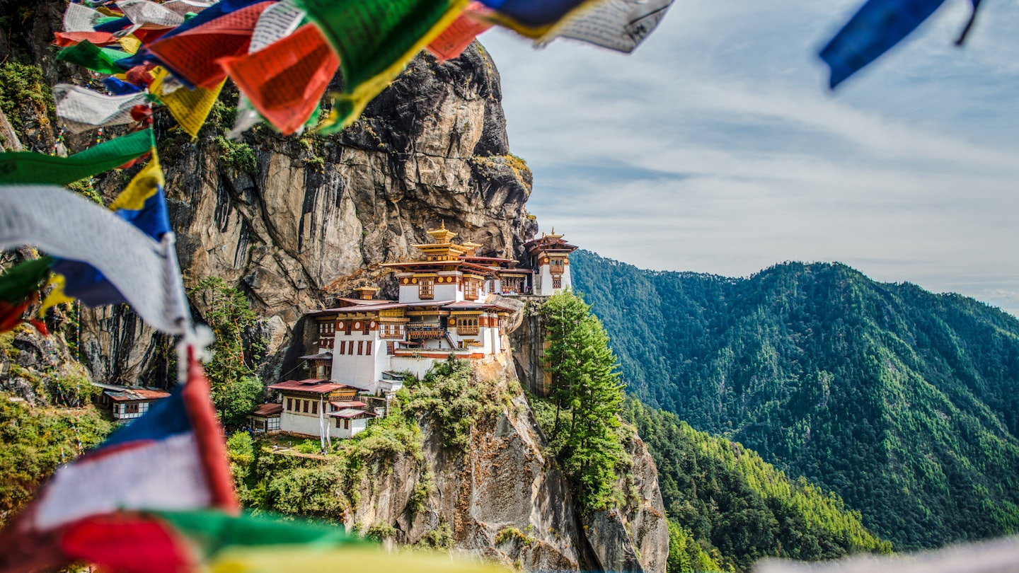
Taktsang Monastery, also known as the Tiger's Nest, with prayer flags view © Shutterstock
Historically a pilgrimage route, the fully-restored Trans Bhutan Trail reopened to visitors in September 2022. Its 250 miles of scenic footpath will offer visitors a unique perspective of the Asian country and likely will become one of the world’s most iconic cross-country walks.
To do the trek, you have to hire a guide who will lead you along this spectacular trail. We asked guide Galey Tenzin to give us an idea of what you might experience over seven days on the Trans Bhutan Trail.

A tour guide for more than a decade and a German-language guide for more than five years, I have explored every corner of my country of Bhutan. I have been involved in the reopening of the Trans Bhutan Trail from the first discussion of the project through restoration of the trail up to the first traversal of its 250-mile (403km) length in almost 60 years. I must say it is truly one of the best trekking destinations ever, allowing one to refresh and reconnect with nature.

The Trans Bhutan Trail is an ancient route through the Himalayas that lets you follow in the footsteps of our ancestors. For hundreds of years, the trail was used by pilgrims, messengers, armies and traders – and until the 1960s, it was the only way to travel through and communicate with others across the country. After Bhutan initiated a process of planned development beginning in the 1960s, a national highway was constructed and the trail fell into disuse. Under the vision of the king of Bhutan, the Bhutan Canada Foundation together with the Tourism Council of Bhutan and other local partners are currently working to restore and reconnect this historic route. To mark the launch of the restored trail in September 2022, a national event had 24 scouts – one from each dzongkhag (district) and four from each thromde (city), representing the entire country – walk the length of the trail in a show of national unity. I led this scout walk for the full 250 miles, from Haa east to Trashigang.
The trail offers exposure to unique culture, multiple dialects, different religious sites and varied flora, fauna and birds – as well as a range of campsites, farm houses, hotels and unique foods. Scenic views and conversations with local people make it even more pleasant and rejuvenating. One can hike through the trail at any time of the year, with each season offering a different experience. (Note that the trail sees snowfall during the winter months, and muddy, challenging conditions in the summer monsoon season.) Visitor-friendly, the trail can be hiked in different sections, with a clear end point for each. QR-coded signposts provide links to texts and comic book–style illustrations that explain the history of each area.
A note: the itinerary outlined below should be relatively easy for those who do regular physical exercise (and no problem at all for trekkers), and moderately demanding for those who go for frequent casual walks. Consider your own physical fitness and health level: we do not recommend this itinerary if you have no experience hiking. All international hikers must be accompanied by a guide.

International flights serve Paro from Kathmandu, Delhi, Guwahati, Bagdogra, Dhaka, Singapore and Bangkok. Before you even step foot in Bhutan you will see what a dramatic land this is from the windows of your dragon-emblazoned Druk Air plane. As you make your descent from over the Himalayas, you’ll enjoy one of the most scenic flights (and hair-raising landings!) you’ve ever experienced.
The airport is situated at an elevation of 7333ft (2235m) in a dramatic valley, and you will feel cool, clean fresh mountain air the minute you disembark from the aircraft. Your tour guide will greet you and drive you to your hotel. After a Bhutanese lunch, you’ll acclimatize to the altitude with an easy walk and tour of Paro. The National Museum once served as a watchtower (or ta dzong), originally built to defend the Rinpung Dzong during the inter-valley wars of the 17th century. A museum since 1967, it today holds a fascinating collection of art, relics, religious Thangka paintings and Bhutan’s exquisite postage stamps. Next, at the majestic Paro Dzong, you can light traditional butter lamps to bring success and safety on your journey to come.
Admire the multi-colored wooden facades, small arched windows and sloping roofs of the typically Bhutanese architecture as your guide relates the story and importance of this dzong. (Some scenes from the 1993 internationally co-produced film Little Buddha were filmed here.) A short walk back toward Paro town takes you across a cantilever bridge that offers a splendid, photogenic evening view of the dzong and ta dzong. Then it’s back to your hotel for dinner.

10 miles (16 km); 7 hours; 2900ft (884m) elevation gain, 1047ft (319m) elevation loss
A 10-minute drive brings you to the beginning of your Trans Bhutan Trail hike. This part of the trail connects three villages: Tsendona, where the trail begins before gently rising through rice fields; Dopshari, where you will stop for lunch; and Damchona, where you will camp overnight. Along the trail, you can take in beautiful views of the Paro Valley and its sights, as well as Kungkarpo, a sacred site for “sky burial.” Keep an eye out for mountain bikers, as this section also serves as a cycling trail – and for planes, too, as they bank overhead alongside the mountain on their final descent into Paro.
Lunch will be set up at Tshering Farm House in Dopshari, where you’ll enjoy organic and traditional Bhutanese foods as well as a beautiful view of rice fields. After lunch, the trail climbs up slowly through the pine trees toward the campsite at Damchona, where apples rather than rice are the local crop, and locals rear cattle and horses. During monsoon season (June–August), count on meeting people foraging for wild chanterelle mushrooms. Upon your arrival at camp, you will be served a hot towel to clean up, followed by hot tea and dinner. When night falls and as the campfire crackles, your tour guide and trail ambassador will narrate the history of the trail.

10.75 miles (17.25 km); 6 hours; 2526ft (770m) elevation gain, 2664ft (812m) elevation loss
After breakfast at camp, you’ll continue on the trail from Damchona to Tsaluna village. The trail’s rise is gradual and the path will be clear of debris thanks to the dozens of horses plying the route each day during trekking season. Tall trees and coniferous forests line the path until Jela Pass (11,575ft/3528m), where you can hoist lungdhar (prayer flags) while saying the prayer “Lha-geh lo” (“May the gods be victorious”). After Jela Pass, the trail drops gently through clusters of rhododendrons. After about 1.25 miles (2km), you will reach an open area that’s a good spot for a picnic, with views toward Pumola and other mountain ridges – and the next section of the trail.
From there, you’ll walk through a settlement called Jadingkha, then through groves of beautiful pine and oak trees until Tsaluna. Along the trail you will hear the calls of such birds as the Himalayan monal, satyr tragopan, fire-tailed myzornis and hoopoe. (Expect a bit of mud, too, as cattle rearing is prevalent in this area.) You’ll be welcomed at your campsite, surrounded by pine trees, with warm evening tea and snacks. With locals, you can try your hand at archery (Bhutan’s national sport) in the ancient manner, using a bow made of bamboo. Your trail ambassador will join you for dinner, and provide a seal to authenticate your completion of this section of the trail. Then, next to the campfire, watch (or even help) the trekking cook prepare your Bhutanese dinner, which might include red rice, ema datsi (chili with cheese), suja (butter tea), momo (steamed dumplings), buckwheat noodles and other tasty dishes.

12.2 miles (19.65km); 9 hours; 3930ft (1198m) elevation gain, 4308ft (1313m) elevation loss
Wake up to the sounds of birds chirping in the pine trees. You’ll start your day with a warm bedside tea served by the trekking crew, before packing up and taking breakfast. From the campsite, the trail ascends gradually, then drops into a steep slope lined with dense oaks. There is hardly any view on this trail – only the sounds of streams and birds. After 3 or 4 hours of walking, you will reach Pumola, where you can rest and relax near a huge stupa. Next, you’ll ascend another steep slope for another 90 minutes up to the peak of Pumola, known locally as Thaptsakha and the highest point on the Trans Bhutan Trail. Along this section, amazing views of mountain ranges, monasteries and the Thimpu Valley will open up along a route that was onced used by messengers traveling between Paro and Thimpu. (Adventurous visitors can retrace that 29-mile/48km route via the Druk Path Trek.) You will have lunch at the peak of Pumola and also offer incense as a way to pay homage to our local deities.
After lunch, the trail descends through a magical landscape of open pastures where yaks graze; stop by a yak-herder’s camp to get a taste of nomadic life. As you get closer to the next section of the trail, you will get a closer view of Thimphu Valley and its famous Buddha statue. This section of the trail will end near this gigantic, 177ft(54m)-tall monument, and you won’t want to miss out on a photo opp in front of it. After so much walking, take a car to your hotel for a hot shower. Feel free to call it a night – or set out to explore small but lively Thimpu on foot.

9.3 miles (15km); 7 hours; 3235ft (986m) elevation gain, 1729ft (527m) elevation loss
After breakfast at your hotel, you’ll drive through from Thimphu to Punakha through the Dochula Pass – a must-visit stop for travelers. Here, colorful prayer flags line the road, with amazing, panoramic views of the snow-covered Himalayas forming a majestic backdrop against 108 chortens (Buddhist shines). After taking photos and hearing stories from your guide, you’ll get out your hiking gear and prepare for your last day on the Trans Bhutan Trail.
The first hour will take you through beautiful rhododendrons and huge hemlock trees, before you drop down through a pine forest and some settlements along the way. (During the growing season from May to July, you will see farmers working their organic fields.) You’ll enjoy lunch below Hongtsho, sampling apples from local orchards as dessert. As you wind your way on to Simtokha, you will cross the same river seven different times. At the end of the hike, a trail ambassador will be waiting for you with tea, snacks and a signature for your Trail Passport to certify your completion of this leg of the journey. After driving back to Paro, you’ll check in at Ughyen Farm House, where you can experience a hot-stone bath and enjoy scrumptious local Bhutanese food. A cultural program featuring mask dances, traditional folk dances and an archery demonstration concludes a full day.
7.5 miles (12km); 7 hours; 2625ft (800m) elevation gain, 394ft (120m) elevation loss
No first-time trip to Bhutan would be complete without a visit to the Tiger’s Nest. Built on a cliff some 9840ft (3000m) above sea level, this extraordinary monastery is one of the most memorable holy sites in the world. Hikers can reach the site via a trail with a natural clay surface, one wide enough for people to walk comfortably. (Note that the trail can become dusty on dry days, and muddy and slippery on wet ones, especially on segments frequented by horses.)
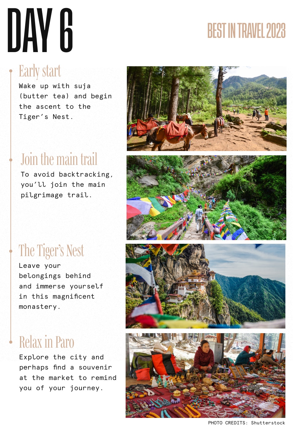
After breakfast with suja (butter tea), you’ll head from the farm house to the Tiger’s Nest “base camp,” where you can use the facilities and buy walking sticks for your hike. (Horses and ponies are available for hire for those unable to hike.) After a 2-hour ascent, you can stop for a bit at the rest area, which has a cafeteria offering tea and food – as well as a view up to the monastery. From the cafeteria, a direct-ascent trail joins the main path after a few hundred meters, saving you backtracking. The main trail continues upward steadily, with a few shortcuts offering a (steep and often slippery) way to save some time; you’ll have excellent views of the monastery throughout.
The path then enters forest again until you reach the traverse trail, which will lead you on a gentle ascent. Along the way you will pass an area where bigger groups sometimes stop for lunch, and the temple at which the former Je Khenpo (head lama) of the Bhutanese Drukpa Kagyu school of Tibetan Buddhism was born. Finally, you will reach the viewpoint, where the majestic sight of Tiger’s Nest monastery will open just in front of you. Though most people stop here for photographs, the best photo spot is about 164ft (50m) farther down, beside a short prayer wheel.
Start descending by the steep concrete stairs down – very carefully, and holding on to the banister, as a misstep could be fatal. Even during the busiest part of the day from 10am to 1pm, when the stairs get jammed with tourists and Bhutanese pilgrims, remember to behave with respect since you are on sacred ground. After losing some 328ft (100m) of altitude, the stairway will lead into the gap between two cliffs below an impressive waterfall. After crossing the bridge, continue up the stairway to the right. This is the last 263ft (80m) of altitude gain before you reach your goal: the entrance to the monastery itself.
Please bear in mind that before you enter, your guide will need to clear you with the guards, and you’ll need to leave your belongings in the lockers; no phones or cameras are allowed inside. What is to be seen and experienced in the monastery is beyond the scope of this article, and we will happily leave the backstory to your competent guide. We will simply reveal that while you sweated and panted on your hike up, the Guru Padmasambhava, the saint who established this place in 8th century, was brought here on the back of a flying tigress who turned out to be his spiritual consort and wife in different form (hence “Tiger’s Nest”). After your temple visit, follow the same way back down. Your lunch will be served at the cafeteria against a view of the temple and amid the sound of birdsong.
After your hike, spend a few hours exploring Paro town and picking up some local products as gifts or souvenirs of Bhutan before heading to your hotel. Since this will be your last day in the country, you can have a relaxing massage and enjoy your night in comfort.
Over breakfast, you’ll prepare to say goodbye to an amazing and extraordinary place. On the way to the airport, reflect on the warm-hearted people you’ve met and the lasting memories you’ve made – ones you’ll keep for a lifetime. The Bhutanese will look forward to seeing you again in this land of endless enchantments. Tashi delek!
