Jun 24, 20269 min read
The 11 best places to go in August 2026Jun 24, 2026
25 MIN READ
Contributors
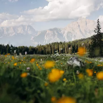
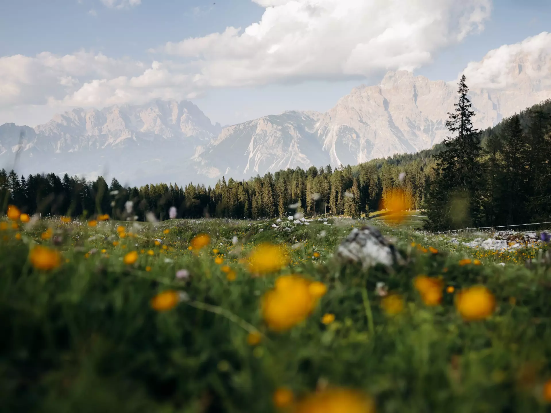
Cortina d'Ampezzo in the Dolomites, Italy. Camilla Ferrari for Lonely Planet
Contributors
Paul Bloomfield, Sarah Baxter
Lonely Planet may earn a commission from affiliate links on our site. All recommendations and reviews reflect our own independent opinions.
The world's greatest hikes don't care what month you want to walk them. Monsoons close Himalayan passes in summer; desert canyons become dangerous in July heat; Patagonia is only at its glorious best between November and March. Timing is everything. This guide – drawn from Lonely Planet's Where to Go When: Hiking – matches you with two unforgettable trails for every month of the year. Wherever you are, whatever time you have: there's a perfect hike waiting.
Length: 60km (37 miles)
Time: 6–8 days
Difficulty: Challenging
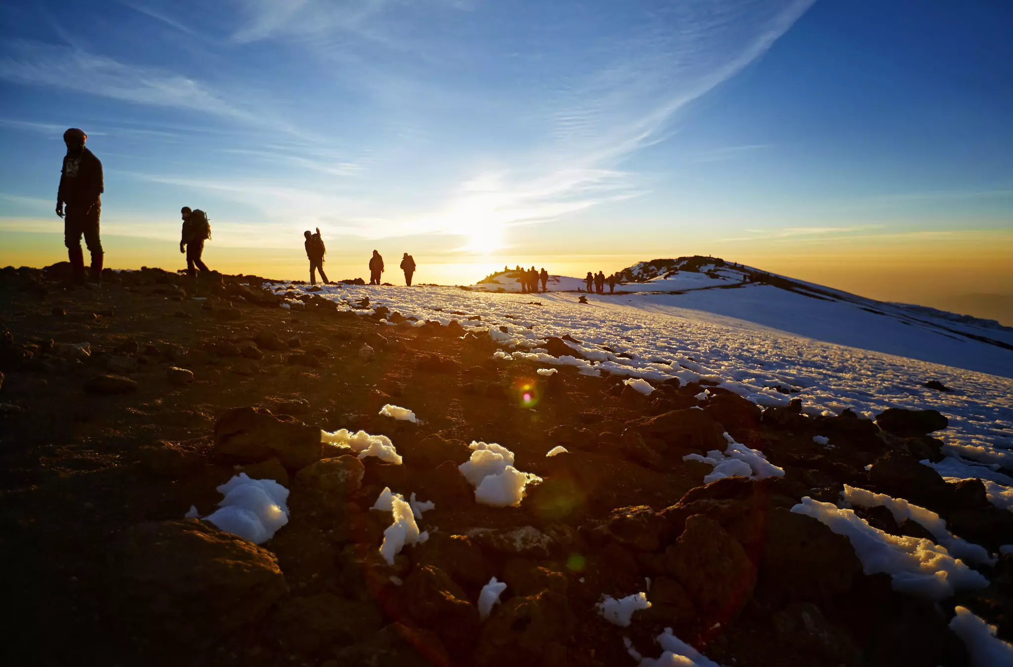
Is there a more tantalizing prospect for the avid trekker than mighty Kilimanjaro? Standing on the Tanzanian savannah only a few klicks south of the equator, looming large and lonely as a god, Kilimanjaro is the highest thing in all Africa. It practically bellows: c'mon then, if you dare.
This dormant volcano is the ultimate achievable challenge. Kilimanjaro rises a lung-scraping 5895m (19,340ft) above sea level but, unlike other peaks of such stature, it demands no technical climbing skills – just a good level of fitness, a bit of patience and hefty doses of grit and determination. To get to the top – to stand, jubilant, at Uhuru (Freedom) Peak – all you must do is walk pole, pole (slowly, slowly), acclimatize to the altitude and dig in.
You can increase your chances of success and have a better time all around by tackling the mountain in optimal weather conditions. The dry seasons are the best time to hike, with the "shorter dry" (January to early March) offering not only mostly clear, rain-free days but also quieter trails than during the peak "long dry" from June to September.
Length: 133km (83 miles)
Time: 6–8 days
Difficulty: Moderate to challenging
There's a popular image of Spain's Canary Islands that's all holiday resorts rammed with sunseeking tourists. Then there's La Gomera. Like the archipelago's other westerly isles, it's less about beach-flopping than boot-yomping. Because the whole of this mountainous, gorge-sliced, sparsely populated Atlantic outcrop is designated a UNESCO Biosphere Reserve, and it's riddled with some 600km (370 miles) of walking routes. Chief of these is the GR132.
This Gran Recorrido (Spanish for "long route") completes a loop of La Gomera, with hikers typically starting and ending in east-coast capital San Sebastián. You could walk it at any time – the Canaries are blessed with great weather year-round. But summers do get hot, pushing 30°C (86°F). The cooler winter months, with average highs just over 20°C (68°F) and very little rain, are most pleasant for hefting up-down on the trails.
The GR132 isn't easy. This is a volcanic island, with barely a flat stretch. It's rough underfoot, riven with geological ructions, and plummets into steep barrancos (ravines). The trail racks up around 8000m (26,247ft) of elevation gain – for the same reason, it's spectacular right out of the box.
Length: 74km (46 miles)
Time: 4–5 days
Difficulty: Moderate
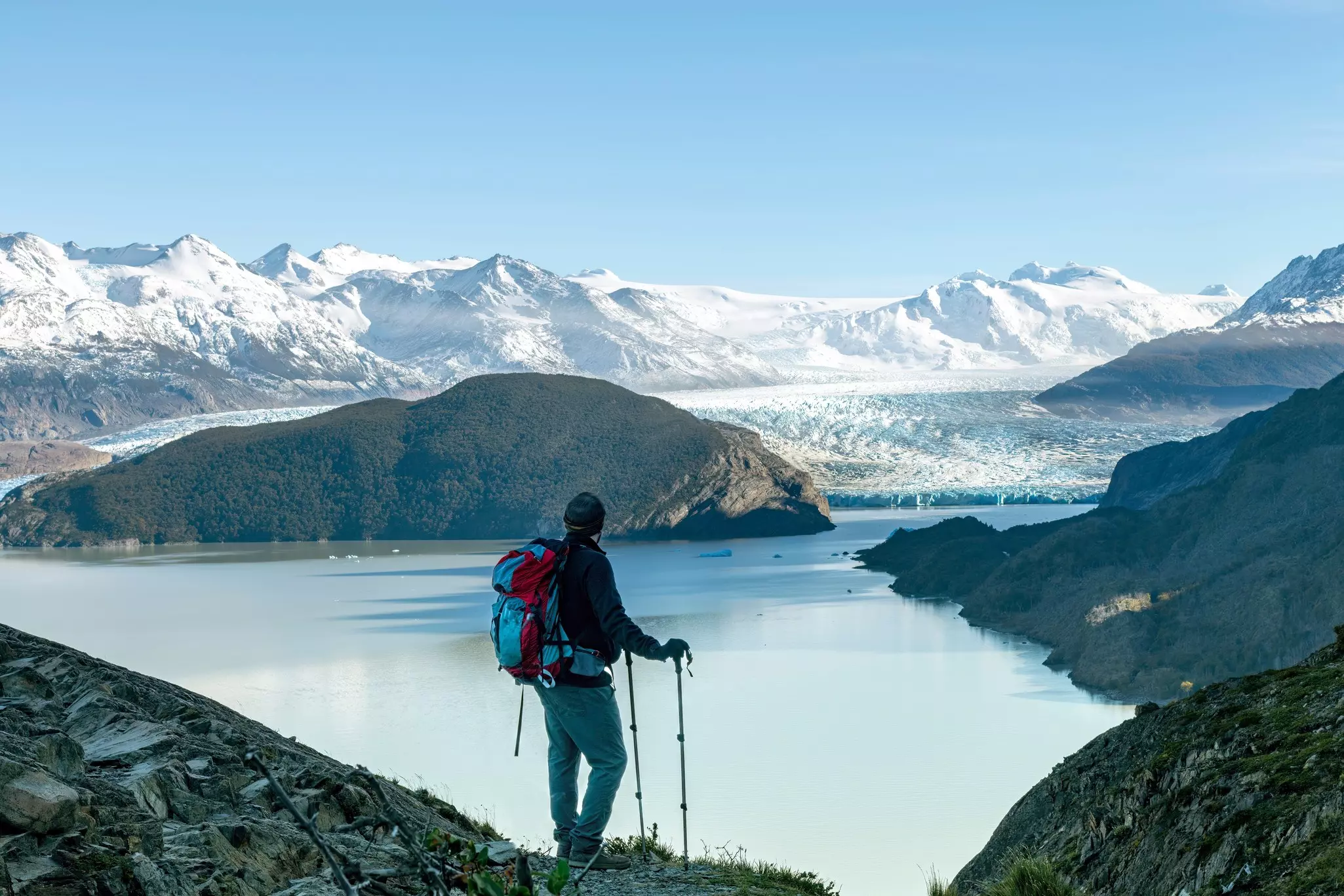
Patagonia isn't quite the end of the Earth, but it does feel a long way from anywhere. And the epic rock pinnacles, glaciers and glimmering lakes and lagoons of Parque Nacional Torres del Paine are suitably out of this world. They form the backdrop to one of the world's finest short treks: the "W."
That letter reflects its shape on a map – but arguably also the wind that buffets hikers as they tramp between the peaks for which the park is named. This region is renowned for weather that changes minute by minute, though the December to February austral summer brings the longest, warmest days. "W" could also mean "wild": you're nigh on guaranteed to encounter guanacos, forebears of domesticated alpacas and llamas, and might even spy puma, huemul deer, flightless rhea or condor soaring overhead.
Starting from Laguna Amarga, the route veers northwest along the Valle Ascencio to the viewpoint for the famed "blue towers" themselves, soaring pinnacles that glow gold at sunrise. Head southwest alongside milky-turquoise Lago Nordenskjöld and beneath the granite "horns" of the Cuernos del Paine to complete the W along the eastern shore of Lago Grey to vast Grey Glacier.
Length: 780km (485 miles)
Time: 30–35 days
Difficulty: Moderate
Pilgrims have been making the trek to Santiago de Compostela since soon after the remains of St James were (reputedly) rediscovered here in the 9th century. The practice then fell out of fashion for several centuries, till it found a new audience over the past few decades. As the desire for more meaningful, mindful travel surged, so too has the desire to walk the Camino – around half a million people now tackle it each year.
Over peak season, from late spring to autumn, in excess of 60,000 souls journey to the Galician city each month to pay their respects at the apostle's tomb and earn their certificate for completing this age-old walk. In the winter months, from December to February, that number falls below 3000.
True, pilgrim camaraderie is a significant part of this walk. But for those hankering after a more solitary, contemplative experience among far sparser crowds, winter is prime time. The way ahead will be much emptier, allowing for more genuine connection with the landscape, the history and oneself. The Camino Francés first crosses the Pyrenees, then sweeps west across northern Spain for 780km (485 miles) to Santiago de Compostela.
Length: 226km (140 miles)
Time: 9–12 days
Difficulty: Moderate
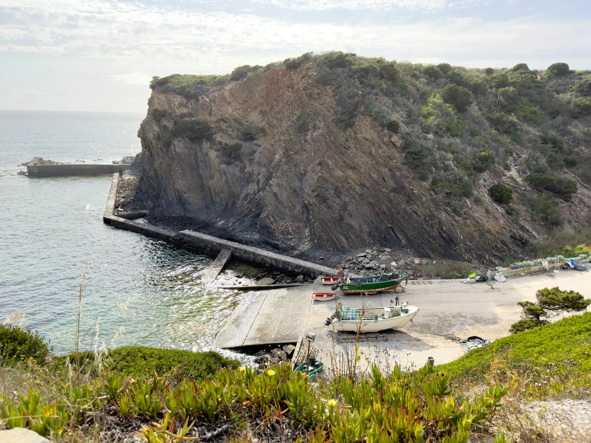
Portugal's southwest coast has a magnetic allure: it simply demands return visits. Just ask the white storks that come back each spring, the monogamous pairs building oversized nests atop chimneys, bell towers and rock stacks. For them, the appeal of this place is clear: ample sunshine and clean air, peace to raise their broods, and plenty of fish, frogs and invertebrates.
The draws for walkers this season are not so very different. The spectacular shoreline of the Parque Natural do Sudoeste Alentejano e Costa Vicentina intersperses golden-sand beaches and windswept cliffs with cork-oak stands, orange groves, and traditional fishing villages and towns where the freshest seafood sizzles in friendly restaurants. As spring progresses, constellations of wildflowers cover the clifftops, and more birdlife throngs the skies and seas. In short, hiking heaven.
This coastal epic ambles wildflower-strewn clifftops, white-sand beaches and past comely fishing settlements where white storks nest, sampling sensational seafood along the way. The trail runs for 226km (140 miles) along Portugal's wild Atlantic coast, one of the finest coastal walks in Europe.
Length: 46km (29 miles)
Time: 4 days
Difficulty: Moderate
The eco-cruise across Port Arthur Bay, spotting cormorants and white-bellied sea eagles is an amuse-bouche for one of the Tasmania's most accessible microadventures.
Taking in two dramatic capes, this moderate hike provides a taster menu of wild Tasmania: cliffs, forest, beaches and all the animals they harbor. Walkers stay in simple cabins, and pass a series of "encounters" – alfresco sculptures evoking natural and historic aspects of the Tasman Peninsula. This gnarled southeastern promontory is exposed to the wildest wind and waves, so many tackle the track in summer. But autumn offers ample benefits: orchids flower and whales migrate past.
Day two kicks off with steep stone steps climbing Arthurs Peak, rewarded with spectacular vistas along the coast to the main destination on day three: Cape Pillar. The path then weaves through stands of stringybark and white gum, across Hurricane Heath and along the narrow, vertiginous-sided isthmus to the cape itself, an awesomely end-of-the-world meeting of rock, sky and roaring sea.
Length: 80km (50 miles)
Time: 4–6 days
Difficulty: Moderate
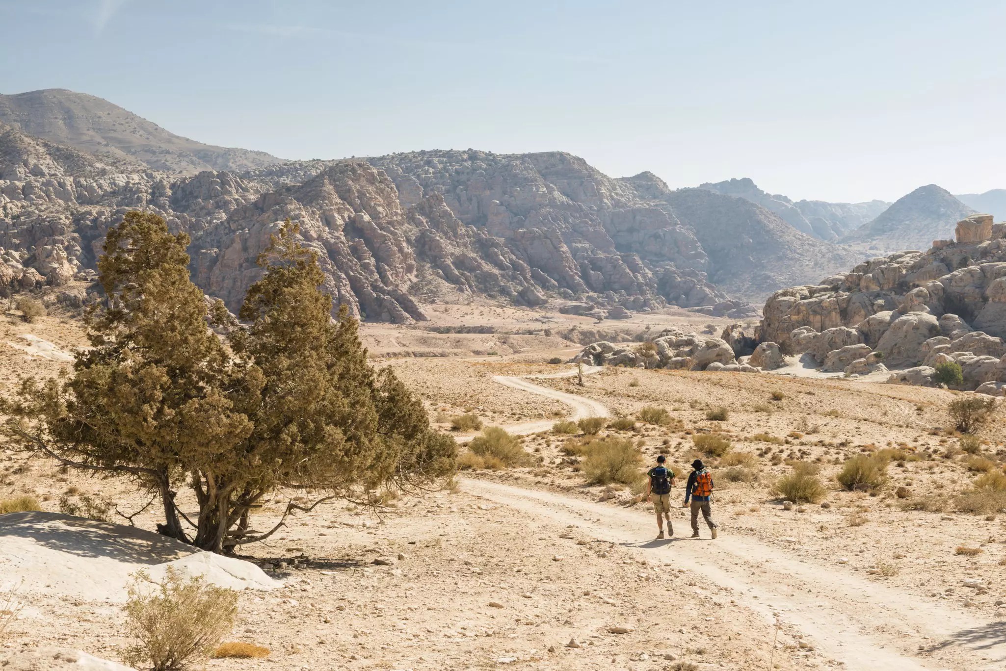
Hikers trace ancient trade routes and Bedouin paths through arid valleys and canyons, skirting the Wadi Araba Desert and passing Byzantine and Nabataean ruins on this spectacular trail – one of the Middle East's finest long-distance walks. Pick up the trail in Dana, a modest village with intriguing Ottoman architecture, and descend from the mountain plateau into Dana Biosphere Reserve.
Despite first impressions of an arid, scrubby, rocky expanse, this reserve encompasses Jordan's four biogeographical zones, home to hundreds of plants and animal species. Keep eyes peeled for Nubian ibex, griffon vultures and sand partridges. Spring is ideal for the northern stretches, after winter's bitter nights but before intense summer heat hits, and when wildflowers bloom on hillsides.
The trail ends at one of the world's great archaeological wonders: Petra, the "Rose City" carved from sandstone by the Nabataeans. The famous reveal of the Treasury – the Khazneh – appearing from the narrow Siq gorge is one of hiking's most dramatic finales. Wild camping under vast desert skies along the way is one of the trail's great pleasures.
Length: 1014km (630 miles)
Time: 30–52 days
Difficulty: Moderate to challenging
The South West Coast Path has long been popular both for its beauty and because it offers plentiful and varied accommodation, relatively easy transport access and ample supply points. Whether you're aiming to complete all 1014km (630 miles) in one epic adventure, or break it up into shorter vacation-length chunks, planning is key. England's longest National Trail circles the entire southwest peninsula through Somerset, Devon and Cornwall.
Each region has its own unique flavor. The first stretch from Minehead through Somerset and north Devon offers wild heath where yellow gorse flowers gleam, and shady woods harbor gems such as England's tiniest parish church at Culbone. Postcard-pretty villages include Porlock, Lynmouth and cobbled Clovelly, while spectacular viewpoints include Great Hangman, the highest sea cliff in England and Wales.
Cornwall looms as the path's most dramatic act: sheer cliffs, crashing surf, ancient engine houses, fishing coves and miles of empty clifftop walking. The finale in Dorset brings the Jurassic Coast, fossil beaches and the curious natural arch of Durdle Door. April's long days and spring wildflowers make it one of the finest times to walk.
Length: 155km (96 miles)
Time: 5–8 days
Difficulty: Moderate
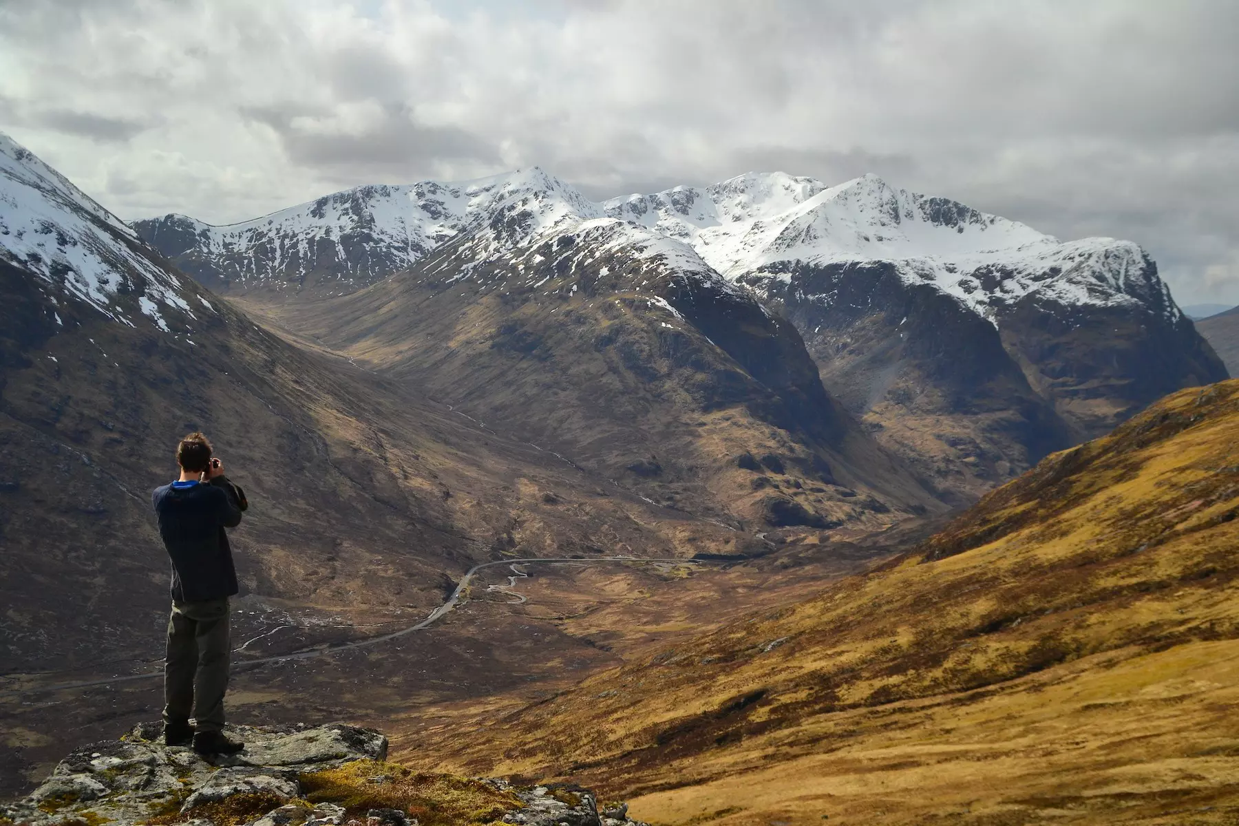
The West Highland Way is Scotland's most popular long-distance trail – for several good reasons. First, it's easily accessible, starting on the outskirts of Glasgow. Second, although there are stiff climbs and wild terrain, it presents a satisfyingly manageable challenge. Third, it ticks off headline sites, from dreamy Loch Lomond to gorgeous Glencoe. And it exudes a powerful sense of drama, building in grandeur with every northward footstep to finish at the foot of Ben Nevis, Scotland's – and Britain's – highest mountain.
It's also a route that offers craic and camaraderie. More than 45,000 people hike the trail each year, with May the most popular time. This month heralds long days, more sunshine and less rain; the gorse is in brilliant-yellow bloom, the woodlands are awash with bluebells – and it's before the maddening midges are out in force.
That means there are more fellow trekkers, and for many hikers, the social aspect adds to the experience. Everyone is writing their own story along the same theme, and there's a delight in swapping tales of bogs, bugs and blisters over a wee dram at a bar each evening.
Length: 34km (21 miles)
Time: 1–2 days
Difficulty: Challenging
Descend into the big, bold, beautiful bowels of the Earth on a matchless Grand Canyon crossing. As the crow flies it's about 16km (10 miles) between the North Rim and the South Rim – but crossing the Colorado Plateau and hefting back up the other side is twice as far. And it ranks as one of the finest short hikes in the world.
The 1.6km (1-mile) deep Grand Canyon is both a rapture of red-orange rock and a 3D geography textbook. Its geological strata chart aeons of planet-making, with the schist at the bottom almost 2 billion years old. Switchbacking down through these layers from the South Rim, via either the South Kaibab or Bright Angel Trails – routes used by the Ancestral Puebloans for centuries – is like going back in time. It's also tough on the knees (pack trekking poles).
Standing on the canyon's floor, where the rims loom out of sight, the cottonwoods grow and the Colorado River roars, will make you feel about as small as an ant. May and early June offer ideal conditions: trails are clear of winter snow, and summer's dangerous heat hasn't yet taken hold.
Length: 179km (111 miles)
Time: 8–10 days
Difficulty: Moderate
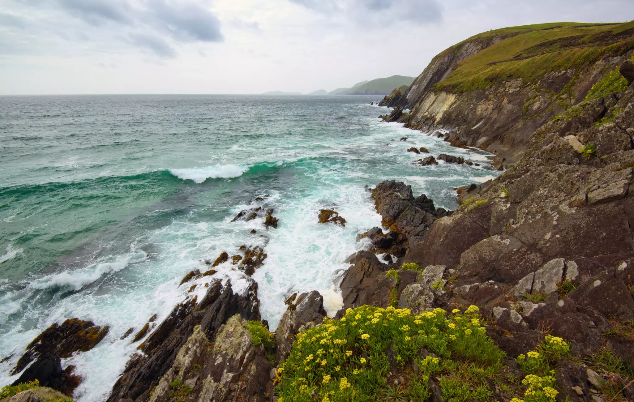
The Dingle Peninsula is Ireland's wildest west, a rugged finger poking out into the Atlantic at the extreme edge of Europe. It feels remote, elemental and tinged with not a little magic thanks to its ephemeral light, ancient relics and the lilting voices of the Gaeltacht (Gaelic-speaking) community. Walkers are especially welcome.
The well-marked Dingle Way circuits the peninsula, offering a sort of Ireland in miniature: it passes lively towns, archaeological sites, emerald meadows, relatively formidable peaks, ocean-smacked cliffs, restaurants serving succulent seafood and wonderful old pubs thrumming with traditional music. The trail is a mix of well-maintained paths and country lanes that thread between hills, beaches, boulder fields and boggy bits.
A visit in late spring or early summer is best for drier, warmer conditions. June in particular offers near-endless days – over 18 hours of daylight on the summer solstice – but sits just before the very peak season, making it easier to find accommodations. Wild Atlantic light transforms the headlands throughout the day, and dolphins are regularly spotted off Slea Head.
Length: 92km (57 miles)
Time: Variable
Difficulty: Moderate to challenging
It wasn't so long ago that a trek through the Balkans would have been unthinkable. Albania was all but closed to the rest of the world until the 1980s; then the 1990s saw war rage across the former Yugoslavia. But times have definitely a-changed. In the early 21st century, an idea was hatched to forge a trail – the Via Dinarica – linking these formerly troubled countries, to build bonds and encourage adventurous outsiders to visit.
And what an adventure: the Dinaric Alps remain some of the least-explored and most untouched reaches on the continent where, for now at least, mountain life is still lived the way it has been for centuries. The Via Dinarica traces the range north–south from Slovenia to Albania via Bosnia and Hercegovina, Kosovo, Croatia, Serbia and Montenegro, using shepherds' paths, military roads, old trade routes and new connections. Stretching over some 1930km (1200 miles), it's one of Europe's longest and most ambitious long-distance routes.
The Bosnian and Montenegrin White Trail sections, walkable June to September, offer the most dramatic mountain scenery: limestone peaks, glacial lakes and the thundering Tara River canyon.
Length: 85km (53 miles)
Time: 4–5 days
Difficulty: Challenging
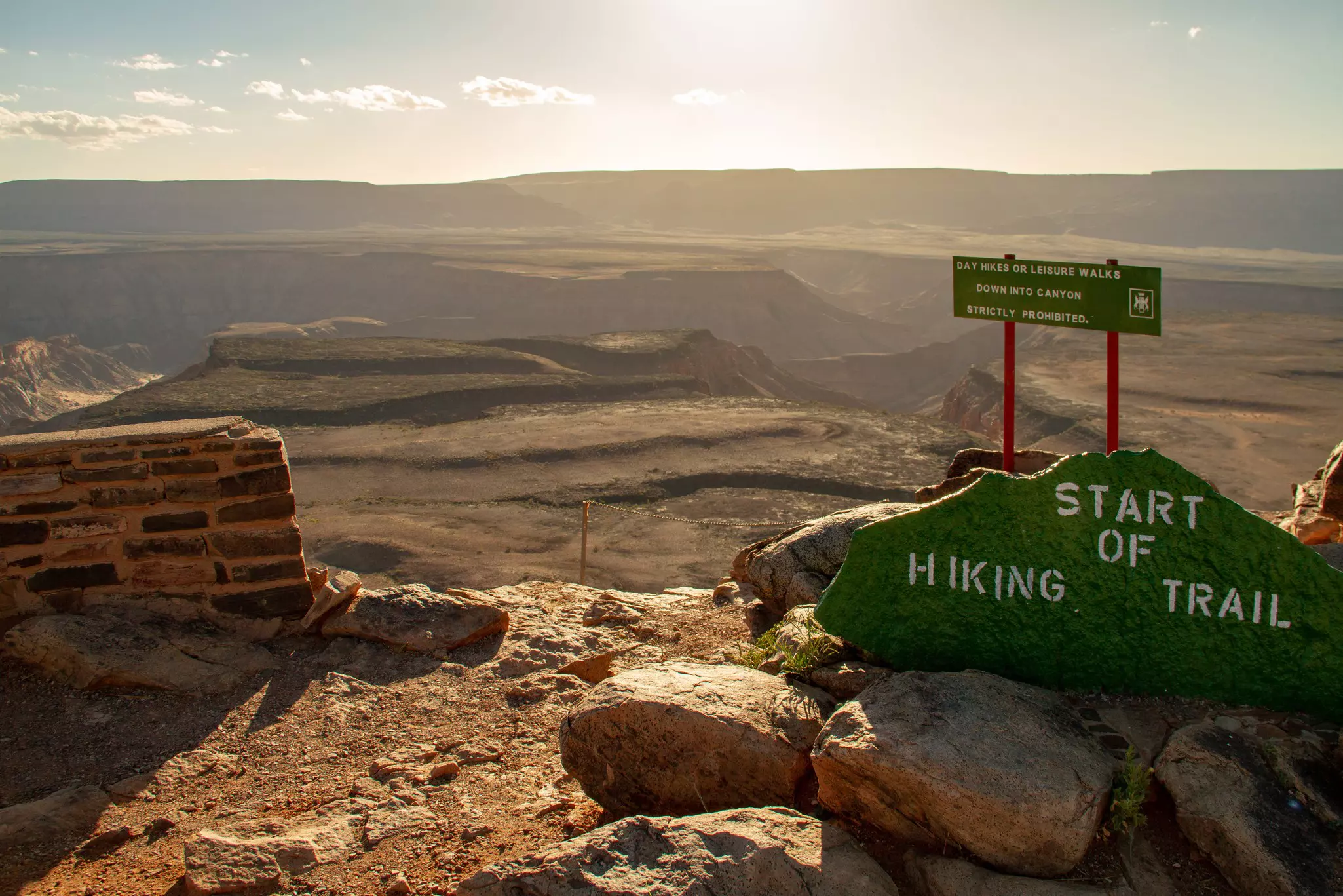
Descend into Africa's greatest, most glorious gorge to trek beneath towering buttresses, graceful horseshoe bends and raw, rugged rock. The Fish River Canyon is one of the largest canyons in the world, a vast gash through the arid Namibian south carved over millennia by the Fish River. The trail runs along its floor for 85km (53 miles), making it one of Africa's greatest wilderness hikes.
The season runs May to September only – summer heat makes the canyon floor impassably dangerous. July sits in the cool heart of the Namibian winter, with daytime temperatures manageable and nights wonderfully cold and starry. The hike has no infrastructure beyond natural water sources and stone bivouac shelters; wild camping in this primordial landscape, beneath the canyon's 550m walls of ancient metamorphic rock, is an elemental experience.
The route begins with a steep descent into the canyon – Hikers' Hell, locals call it – and then follows the river, or its sandy bed, for 4 to 5 days to the finish at Ai-Ais Hot Springs Resort, where a soak in the thermal pool is the finest possible reward.
Length: 75km (47 miles)
Time: 5–7 days
Difficulty: Challenging
Don't underestimate the West Coast Trail. It's only 75km (47 miles) long, with relatively low elevation gain, but it's challenging. Tracing some of Vancouver Island's most ravishing Pacific-smashed shores, it's properly remote, with no settlements, shelters, shops or eateries (save for Nitinaht's beloved Crabshack floating restaurant). There are also more than 100 ladders to climb and descend, angry rivers to ford, deep gullies to cross, fallen trees to hoist over, boulders to scramble, mud to slog through, bears to avoid. But the rewards include a wonderland of old-growth rainforest, untouched beaches, caves, coves, cliffs, superlative sunsets and chances to spot sea lions, otters and whales.
The coastline between Pachena Bay and Gordon River lies within the traditional territories of Huu-ay-aht, Ditidaht and Pacheedaht First Nations peoples, who traveled and traded here for millennia. The trail is open only from May 1 to September 30, with just 75 hikers permitted to start each day. July is one of the busiest months, with the warmest, driest, clearest weather and long hours of daylight.
Length: 107km (66.5 miles)
Time: 5–7 days
Difficulty: Moderate
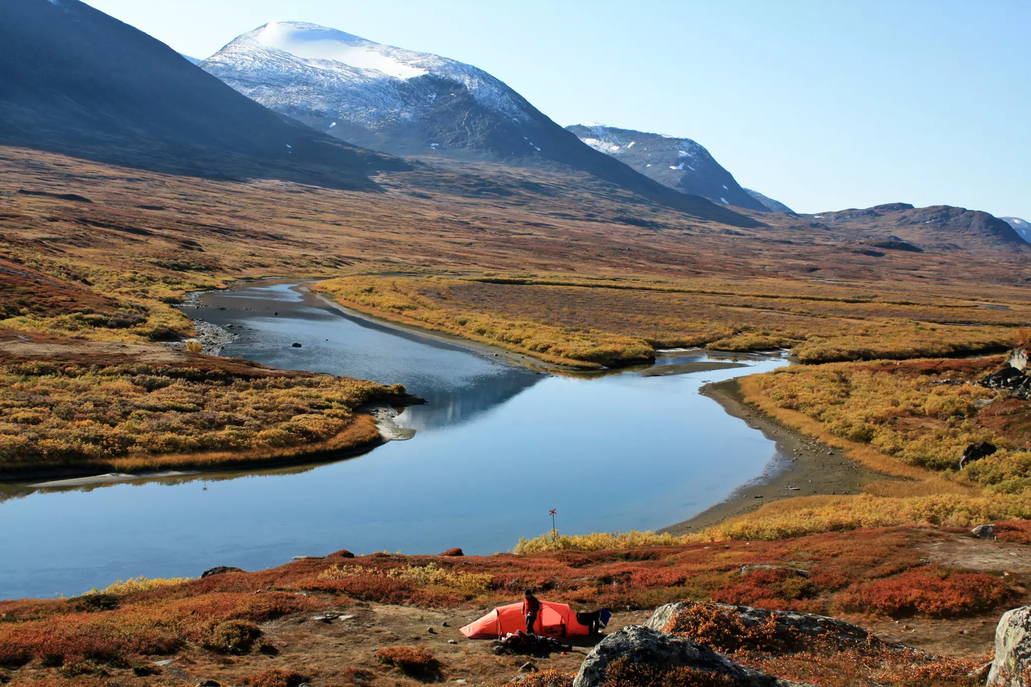
Trust the Scandinavians. Create a 460km (286-mile) hiking trail through the big-sky expanses of Sweden's far north? Start high above the Arctic Circle in Lapland, where the mercury frequently plummets to -20°C (-4°F)? Waymark paths and build boardwalks across permafrost and bog, beneath jagged peaks and through birch forests, installing comfortable cabins and mountain stations for trekkers en route? No problem. That's what the Svenska Turistföreningen (Swedish Tourist Association; STF) did in the early 20th century, linking together sections of historic paths. The majestic result was given a suitably regal name: Kungsleden, the King's Trail.
In the decades since, it's become a byword for wilderness walking. August brings the longest days, when the sun hardly sets. Sweet, golden-yellow cloudberries – nature's perfect trail food – fruit among the bogs. Alpine flowers bloom, young animals abound, and temperatures are at their most clement. From the northern trailhead at Abisko, the route passes beneath Sweden's highest mountain, Kebnekaise (2104m), making this section the most dramatic and popular stretch.
Length: 223km (139 miles)
Time: 12–20 days
Difficulty: Challenging
The Larapinta Trail is one of Australia's great long-distance walks. The trail follows the West MacDonnell Ranges from Alice Springs through spectacular ancient landscapes that have been inhabited for more than 10,000 years. It can be walked in either direction, though most choose to hike east–west, beginning at Alice Springs Telegraph Station (dating back to 1872). Ahead lies a wilderness of witchetty bush, mulga scrub, ghost gums and eucalypt groves, of winding creeks and sinuous gorges, of rocky ridges and summits that overlook this primordial world.
The trail is well waymarked and broken into 12 stages. Standouts include Sections 4 and 5, from Standley Chasm to Hugh Gorge; this stretch leads over Reveal Saddle to Brinkley Bluff, an amazing spot to camp and look down the range's spine. There are refreshing dips in waterholes en route – when appropriate, as some are sacred to the Arrernte people. August is the driest period, with desert wildflowers beginning to surge back to life – a good time to walk, not as fierce as summer when the mercury can push above 35°C (95°F).
Length: 120km (75 miles)
Time: 8–12 days
Difficulty: Moderate to challenging
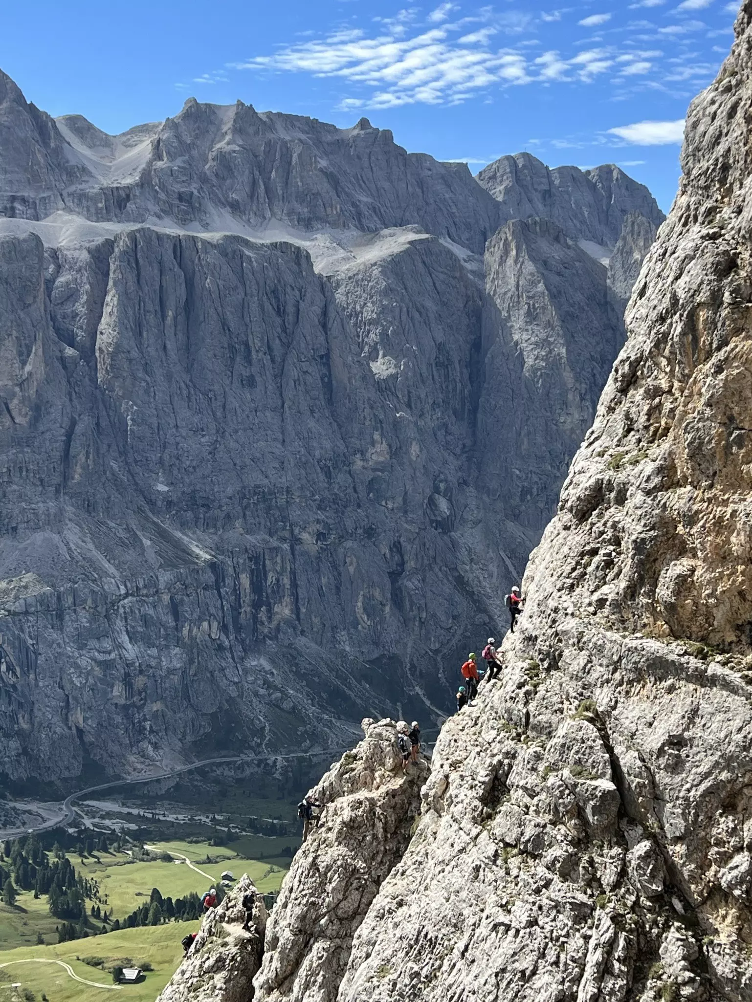
Alta Via 1 is very well named. It's an alta via – "high road" – both literally and metaphorically, offering soul-lifting trekking through the dazzling Dolomites. It's also an appropriate "number one" hike: rugged but not frighteningly tough, it's a good option for Alpine first-timers.
Over the course of ten or so days, the Alta Via 1 yields a bit of everything. There are dramatic ramparts of limestone and dolomitic rock, passes reaching up to 2752m (9029ft), meadows festooned with wildflowers, welcoming rifugi (mountain huts) dishing up hearty portions of fine food and bonhomie, and even thrilling (but not too scary) sections where metal handrails help you negotiate the wild terrain.
There's also a wealth of history. During WWI, the fortress-like Dolomites became a bloody if beautiful front line where Italian and Austro-Hungarian forces battled for 4 years. The remains of their high-altitude skirmishes – via ferrata (mountain trails with cables and ladders), gun emplacements, tunnels and trenches – can still be seen along the trail. September brings cooler temperatures and fewer crowds than July or August, and the rifugi are still open for another few weeks.
Length: 82km (51 miles)
Time: 3–5 days
Difficulty: Moderate
Time your trek for the most special season to complete this Finnish classic. The Finns call it ruska – the fleeting season when, for a few weeks in early autumn, the forest transforms into a riotous blaze of color. Bilberries, crowberries and cloudberries ripen on the fell, the birch turns gold, and the whole landscape seems to glow. It's certainly a tasty time to walk: the berries are ripe for the plucking along the entire trail.
An important conservation area, Oulanka National Park is home to more than 400 protected animal and plant species, vital flood meadows, and some of the most dramatic gorge scenery in Finland. The Karhunkierros ("Bear's Ring") trail loops through this landscape on well-maintained boardwalks and suspension bridges, past thundering rapids and deep ravines carved by the Oulankajoki and Kitkajoki rivers.
The trail is dotted with wilderness huts and lean-to shelters, making it accessible to hikers of moderate fitness. September brings the ruska at its peak, plus cooler temperatures ideal for sustained walking, and the lingering amber light of early autumn evenings.
Length: 66km (41 miles)
Time: 4–5 days
Difficulty: Moderate
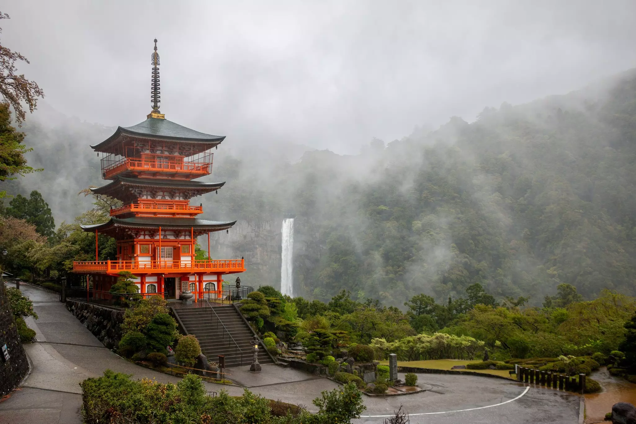
Discover how the ancient Shinto shrines and Buddhist temples of the Kii Peninsula have influenced Japan's spiritual practices and architecture over many centuries on a walk that is one of only two pilgrimage routes in the world designated a UNESCO World Heritage Site – the other being the Camino de Santiago.
Most popular of the trails is the Nakahechi, known as the Imperial Route. With its start a short bus ride from Kii-Tanabe Train Station and its end close to Shingu's station, it's accessible, attractive and achievable for hikers with a moderate level of fitness and experience. Clearly waymarked and made up of mostly well-maintained stone-paved paths, this route links a succession of grand shrines, ancient cedar forests, and small settlements where hikers can soak in onsen (natural hot springs) and sample local cuisine – specialities include shishi-nabe (wild boar hotpot), river fish and mehari sushi.
October is perfect: autumn maples blaze crimson above the stone-paved paths, temple incense drifts through the forest, and the sense of arrival at the three Grand Shrines of Kumano carries a spiritual weight regardless of religious belief.
Length: 309km (192 miles)
Time: 12–18 days
Difficulty: Moderate
When the Coast to Coast was conceived by pioneering rambler and writer Alfred Wainwright in the early 1970s, he was enthusiastic, claiming: "Surely there cannot be a finer itinerary for a long-distance walk!" He had a point. Yet it's taken more than 50 years for one of Britain's most popular multiday hikes to finally become an official National Trail – a status it was given in 2025. As a result, the Coast to Coast now has proper signage and better accessibility, and is managed to higher environmental standards.
Wainwright certainly knew how to plot a great walk. His country-crossing trail runs between the Cumbrian village of St Bees, on England's west coast, and Robin Hood's Bay, North Yorkshire; between the two, the Coast to Coast up-downs via three of England's most magnificent national parks: the Lake District, the Yorkshire Dales and the North York Moors.
Most people walk west–east, beginning in Wainwright's beloved Lake District after a traditional dip of toes in the Irish Sea. Eventually the mood changes from rugged fells to limestone dales, the sweeping River Swale, and swathes of windswept heather-flecked uplands that finally afford views to the sea. The finale drops into Robin Hood's Bay – where a further toe-dunk in the North Sea bookends your hike.
Length: 32km (20 miles)
Time: 2–4 days
Difficulty: Moderate
What makes one hike better than another? Is it widescreen views, well-maintained paths, rich cultural interactions, varied wildlife encounters, a challenging summit, unforgettable food? Or maybe it's simply reputation and bragging rights?
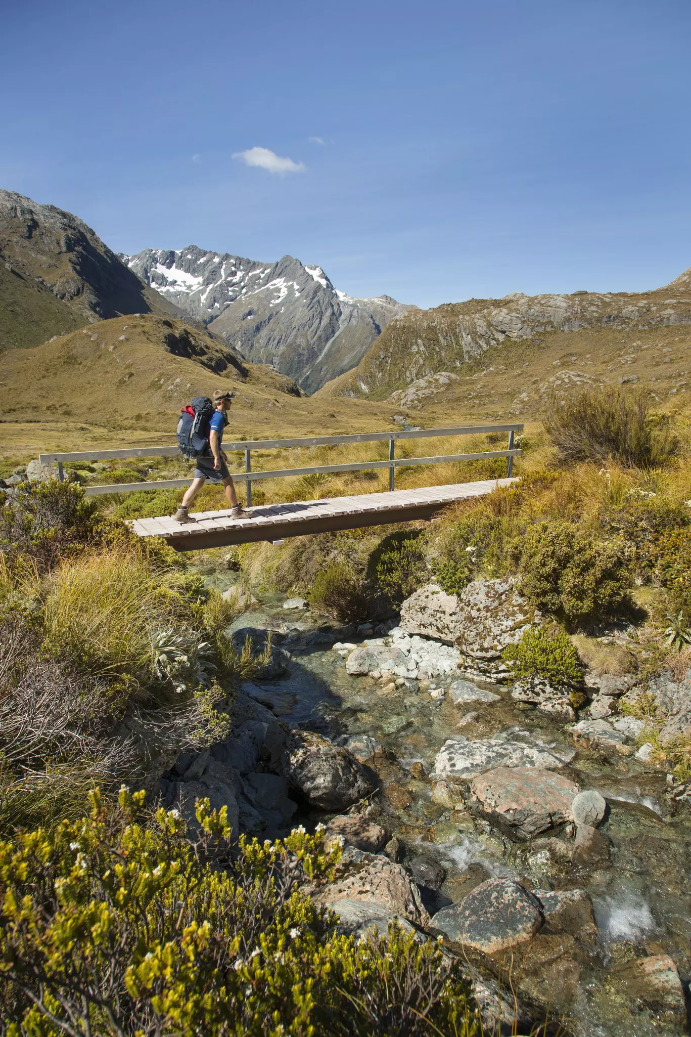
If the idea of ranking treks seems faintly absurd, there's no denying that New Zealand's 11 Great Walks deserve the label. The Routeburn Track is one of the most aspirational Great Walks, an alpine epic that – appropriately enough – straddles Mt Aspiring and Fiordland National Parks in the far southwest of South Island. True, it's not so very long – in fact, a fit hiker could complete it in one long day – but its varied ecosystems, rock formations and grand mountain vistas mean that taking it slowly over 3 days is the way to go.
At the start of the November to April Great Walks Season, forests are lush and mountainsides green, summits still snowcapped, and paths, campsites and huts a little less busy than at the height of summer. The views down towards Lake Mackenzie from Harris Saddle are arguably the most impressive on the trail, though the Routeburn is sensational whichever way you walk it, and is achievable by moderately fit hikers.
Length: 100km (62 miles)
Time: 4–8 days
Difficulty: Moderate to challenging
Think you know Hong Kong? The hyper-modern, densely populated forest of gleaming skyscrapers overlooking its namesake harbor? Well, yes – that's Hong Kong. But stretching north of uber-urban Kowloon are the so-called New Territories. In this surprisingly verdant, undulating expanse, country parks host a range of wildlife as well as fascinating pockets of history: ghost villages, traditional cemeteries, trenches and pillboxes left over from WWII.
And snaking almost all the way across the peninsula is the longest hiking route in the Special Administrative Region. Named for colonial governor Murray MacLehose, who championed the protection of Hong Kong's remaining countryside and spearheaded the creation of its country parks, the MacLehose Trail opened in 1979. Winding through the Sai Kung Peninsula, the trail then veers west along ridges above Kowloon before descending to finish near Tuen Mun.
October to March is the ideal window – the typhoon season has passed, humidity has dropped, and temperatures around 20°C (68°F) make the relentless ridgeline walking comfortable rather than punishing.

Length: 66km (41 miles)
Time: 4 days
Difficulty: Challenging
This backcountry loop promises crevasse-sliced glaciers, angry rivers, violent winds – and the adventure of a lifetime. The Huemul Circuit is a truly tough trek. Venturing into the icy, windy wilds of Parque Nacional Los Glaciares, it takes only 4 days to complete but has gained a reputation as one of Patagonia's most challenging hikes. It requires navigating shifting glaciers, unforgiving mountains and turbulent rivers, twice by means of a Tyrolean traverse – a harness-and-pulley system for which you must click in and haul yourself across a gorge on a wire, dangling over frothing white water.
And all of this in the face of the notoriously fickle Patagonian weather, which invariably means relentless wind. The peak summer months of December to February bring clear, sunny, warmer days, with highs of around 17°C (62°F). As the Huemul is more strenuous and lesser-known than many of the region's routes, it remains relatively quiet even in peak season.
Days are packed with vistas: up to a battalion of razor-sharp peaks including mighty Mt Fitz Roy, over Viedma Glacier, across the Southern Patagonian Icefield. At night you'll be lulled to sleep by the sound of calving bergs as you camp beneath a billion stars.
Length: 42km (26 miles)
Time: 2 days
Difficulty: Moderate to challenging
The Hajar Mountains are some of the highest in Arabia, and the E35 trail is an iconic crossing of a high Hajar plateau along an ancient donkey track, linking the two lush oases of Wadi Bani Jabir and Wadi Bani Khalid. It's a 2-day journey, camping halfway on top of the plateau at around 2000m (6560ft). The night will be chilly, but the sunsets, sunrises and star-filled skies make the experience unforgettable.
The trail descends into Wadi Bani Khalid, one of Oman's most beautiful wadis, with clear turquoise pools and towering walls of rust-red rock. The contrast between the stark, wind-scoured plateau above and the lush, palm-fringed oasis below is dramatic and deeply satisfying. October to April is the ideal season, when temperatures are cool enough for sustained walking.
Oman's mountains are made for hiking: well-maintained ancient pathways, traditional mountain villages where hospitality is a way of life, and a near-complete absence of tourist infrastructure mean this is as close to genuine wilderness walking as Arabia can offer.
This article is adapted from Lonely Planet's new book Were to Go When: Hiking , published in May 2026.
Explore related stories