Advertisement
The best 8 hikes in Italy for high peaks and open skies


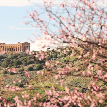
Selvaggio Blu, on Italy's east coast. ValerioMei/Shutterstock
From Sardinia’s ravishing coastlines to Campania’s terraced citrus groves to the jagged spires of the Dolomites, Italy is a boot made for walking. Exploring this country on foot can mean anything from a breezy lakeside stroll to a history-packed amble on an ancient Roman road, to an adrenaline-pumping volcano climb.
Italy’s heritage as a hiking destination dates back at least as far as 1863, when the Club Alpino Italiano (CAI) was founded. These days, walkers from around the globe flock to Italy for its vast trail network, diversity of landscapes and fabulous food. The world-renowned paths of the Dolomites and Cinque Terre draw the biggest crowds, while other prime hiking spots such as Abruzzo and Piedmont remain largely off the international tourist radar.

1. Sella-Herbetet Traverse, Piedmont
Best hike in the Italian Alps
Distance: 15km (9.3 miles)
Time commitment: 7.5 hours
Difficulty: Challenging
Advertisement
If you’re craving an Alpine challenge, the Parco Nazionale del Gran Paradiso in northwestern Italy is a feast. Snug against the French border, the country’s oldest national park is a mind-blowing wilderness of piercing blue lakes, deep forests, rushing rivers and gnarly crags, topping out at its eponymous 4061m (13,323ft) peak.
This classic loop begins with a relentless 908m (2979ft) climb up an old mule trail up to Rifugio Sella, a former hunting lodge of King Vittorio Emanuele II. Pause at the rustic eatery here for a welcome lunch break.
Next, prepare for adventure on the exhilarating two-hour high-country traverse to Casolari dell'Herbetet, a cluster of slate-roofed stone farmhouses flanked by a natural spring; cling to the rope provided in the more exposed stretches. The views across the valley will make you gasp: spiky peaks, small glaciers glinting on the eastern skyline and the mighty Ghiacciaio Tribolazioni below Gran Paradiso itself. Herds of ibex and chamois graze peacefully on steep patches of grass, while marmots chirp from the scree-strewn slopes. After a steep descent to the Torrente Valnontey, enjoy a final 1½-hour amble downvalley, serenaded by the rushing river.
Start from the bridge near Valnontey’s village parking lot, following signs for Rifugio V Sella.
Planning tip: Tackle this one on a clear day; you’ll need to be surefooted and have a head for heights.
2. Tre Cime di Lavaredo, Dolomites
Best hike in the Dolomites
Distance: 9km (5.6 miles)
Time commitment: 3.5 hours
Difficulty: moderate
Jutting above the meadows, lakes and spruce forests of northeastern Italy, the cloud-scraping limestone spires, buttresses and towers of the Dolomites offer some of Europe's most compelling walking country. If you're going to do just one day hike here, make it the Tre Cime di Lavaredo Circuit in the Parco Naturale Tre Cime.
Kicking off at Rifugio Auronzo, the trail weaves around to Rifugio Lavaredo and then clambers up to 2454m (8051ft) Forcella di Lavaredo, before looping back around via Rifugio Locatelli. Throughout the journey, you’re treated to dazzling close-up views of the Tre Cime – a trilogy of photogenic peaks shaped like bishops' miters.
Reach the trailhead via shuttle bus from Dobbiaco, or reserve ahead to drive the toll road from Misurina.
Planning tip: Get an early start to avoid afternoon thunderstorms and crowds.

3. Sentiero degli Dei, Amalfi Coast
Best hike for coastal scenery
Distance: 8km (5 miles)
Time commitment: 3.5 hours
Difficulty: moderate
True to its name, the Sentiero degli Dei (Path of the Gods) presents a heavenly canvas of southern Italian landscapes. The trail affords sensational views of the densely wooded Lattari mountains plunging down to haphazardly tumbled, candy-colored seaside villages, with distant glimpses of Capri across the glittering Mediterranean. You can nail it in half a day, but with scenery like this, why rush? Pack a picnic and grab a walking map from local tourist offices.
Advertisement
Following an elevated, often rocky mule trail on its undulating course from Bomerano’s village square towards postcard-perfect Positano, the path unzips some of the area's least-developed countryside with minimal effort. You'll traipse along terraced hillsides, through lemon orchards and fragrant macchia (scrub) of rosemary and holm oak. From Nocelle, a flight of 1500 steps trips gleefully down to Arienzo, where you can pause for a cooling dip, seafood lunch and cocktail at the beach club. The sunsets here are something else.
4. Corno Grande, Abruzzo
Best mountain ascent
Distance: 9km (5.6 miles)
Time commitment: 6 hours
Difficulty: challenging
Presiding over the jagged rockscapes of the Parco Nazionale del Gran Sasso, Corno Grande ("Big Horn") is the highest peak in the Apennines, at 2192m (7191ft). Its distinctive craggy profile etches the horizon and is visible all over Abruzzo, right in the heart of Italy.
From the Hotel Campo Imperatore parking lot, hook onto the via normale (normal route). It's a surprisingly straightforward climb along moraine-streaked slopes to the summit, with 782m (2565ft) of ascent and some easy scrambling on the final leg. At the top, you’ll be gripped by views of rippling mountains and the distantly glimmering Adriatic, as well as tantalizing glimpses of Europe's southernmost glacier, the Calderone.
Experienced hikers seeking a challenge can choose the much tougher alternative ascent that zigzags directly to the summit. In the quiet of the early morning or late afternoon, you might spot a nimble-footed chamois or a royal eagle wheeling overhead.
Planning tip: Visit from early June to late September when the mountain is free of snow.

5. Sentiero Verde Azzurro, Cinque Terre
Best village-to-village hike
Distance: 13.5km (8.4 miles)
Time commitment: 6 hours
Difficulty: moderate
Yes, the five precariously perched, pastel-colored fishing villages known as Cinque Terre really are as stunning as the photos you’ve seen. The Sentiero Verde Azzurro (previously known as Sentiero Azzurro) strings them all spectacularly together, teetering through vineyards, olive groves and forests as it hugs the terraced hillsides above the sapphire Ligurian Sea.
Landslides periodically close some parts of the trail. The good news is that the popular 1km (0.6 miles) Via dell’Amore between Riomaggiore and Manarola was reopened in 2024 after 12 years of reconstruction. As of mid-2025, only the coastal trail between Manarola and Corniglia remained closed, requiring a steep uphill detour via Volastra. Visit the website for the latest trail conditions and alternate route information.
The trail is best walked east to west, from Riomaggiore to Monterosso. The easternmost Via dell’Amore section is always one-way, and the park service imposes similar one-way restrictions on the entire Riomaggiore to Vernazza section during busy periods; see the Cinque Terre National Park website for details.
To reach the Via dell’Amore entrance, turn left upon exiting the Riomaggiore train station.
Planning tip: You’ll need a Cinque Terre Card (from €7.50, or US$8.50) for most trails in the national park; advance reservations are advisable for the Via dell’Amore, which requires an additional fee. This is one of Italy’s most popular trails; visit early or late in the day to avoid the crowds.
6. Lago di Braies, Dolomites
Best hike for families
Distance: 3.5km (2.2 miles)
Time commitment: 1 hour
Difficulty: easy
This easygoing loop circles the shores of the gorgeous, mountain-ringed Lago di Braies (Pragser Wildsee), immortalized in local Ladin legend as the gateway to the underworld.
The first section along the western lakeshore is a broad flat path that readily accommodates strollers and wheelchairs. You’re instantly rewarded with splendid vistas of the emerald green lake, backed by the imposing peaks of Seekofel (2810m/9219ft), Grosser Rosskofel (2559m/8395ft) and Herrstein (2447m/8028ft) in Parco Naturale di Fanes-Sennes-Braies. The trail meanders in and out of shady forest, affording glimpses of holidaymakers plying the placid waters in vintage wooden rowboats.
A broad expanse of pebbly beach at the lake’s southern edge makes an invigorating swimming spot. Return the way you came, or complete the loop along the eastern shore, pausing for a final photo opp at benches marking the trail’s 100m (328ft) high point.
Planning tip: Paid parking is available adjacent to the trailhead at Hotel Lago di Braies; reserve ahead in summer.

7. Via Appia Antica, Rome
Best hike for history
Distance: 12.9km (8 miles)
Time commitment: 3 hours
Difficulty: easy to moderate
Leave Rome’s frenetic buzz behind and slip into peaceful, cypress-dotted countryside on the Via Appia Antica (the Appian Way). The Roman Empire’s first mighty highway was built between 312 BCE and 190 BCE to link Rome and the port of Brindisi on the southern Adriatic coast.
While much of it is overgrown and inaccessible nowadays, this stretch just outside Rome’s city limits offers a tantalizing peek at what travel would have been like more than 2000 years ago, as you tread cobblestones polished smooth by millennia of cart wheels, horse hooves and hobnailed Roman caligae (heavy-soled military sandals).
The walk begins at the 5th-century Porta San Sebastiano, the largest of the gates in the Aurelian Walls, and ends at the 2nd-century Villa dei Quintili. En route, factor in stops at tiny Chiesa del Domine Quo Vadis, where St Peter encountered a vision of Jesus; the Catacombe di San Callisto, where 16 popes, dozens of martyrs and thousands upon thousands of Christians lie entombed; and Villa di Massenzio, the 4th-century palace of the emperor Maxentius, where you’ll find Rome’s best-preserved chariot racetrack, the Circo di Massenzio.
8. Selvaggio Blu, Sardinia
Best hardcore, multi-day trek
Distance: 45km (28 miles)
Time commitment: 4–7 days
Difficulty: challenging
Often hailed as Italy's toughest trek, this epic jaunt along Sardinia’s rugged east coast is a never-to-be-forgotten, away-from-the-world adventure that requires mountaineering experience. Signs and water are desperately lacking, finding trailheads is tricky (even with GPS), and the going can be grueling, with abseils of up to 45m (148ft) and UIAA grade IV+ climbs.
Heading south to north from Pedra Longa to Cala Fuili, the multi-day hike wriggles along one of Italy's wildest and most isolated coastlines, with deep gorges, impenetrable vegetation, cliffs dipping up to 800m (2625ft) and unrivaled views of the Mediterranean. Old shepherds' and charcoal burners' paths weave past silent coves and dramatic overhangs. By night, you’ll camp under the starriest of night skies at remote beaches and in caves.
Planning tip: Unless you’re an experienced mountaineer, you’ll need a guide, such as climbing pro Corrado Conca.
Top tips for hiking in Italy
Good sources for hiking maps and apps include Kompass, Cart Guide, Tabacco and Iter Edizioni.
The Italian Parks organization lists walking itineraries in each of the country’s 25 national parks.
For overnight lodging on longer hikes, CAI maintains a nationwide network of rifugi (mountain huts); book well in advance. Many independently operated huts in the Alps and Dolomites also welcome day hikers for a lunch break.
Avoid hiking in peak summer season, especially during the Ferragosto holidays in mid-August, when accommodation prices soar and trails are at their most crowded.
Advertisement
Take your Italy trip with Lonely Planet Journeys
Time to book that trip to Italy
Lonely Planet Journeys takes you there with fully customizable trips to top destinations – all crafted by our local experts.