10 of the best hikes in Sicily
Feb 6, 2026
11 MIN READ
Writer
Highlights
Writer Gregor Clark picks 10 hikes across Sicily's volcanoes, coasts and islands.
Watch eruptions on guided Stromboli tours, or tackle iconic Mt Etna's black ash slopes.
Head to Riserva Zingaro for secluded beaches, or Vendicari for bird-watching and flamingos.
Pantalica's Bronze Age tombs and La Rocca above Cefalù reward history-minded hikers.
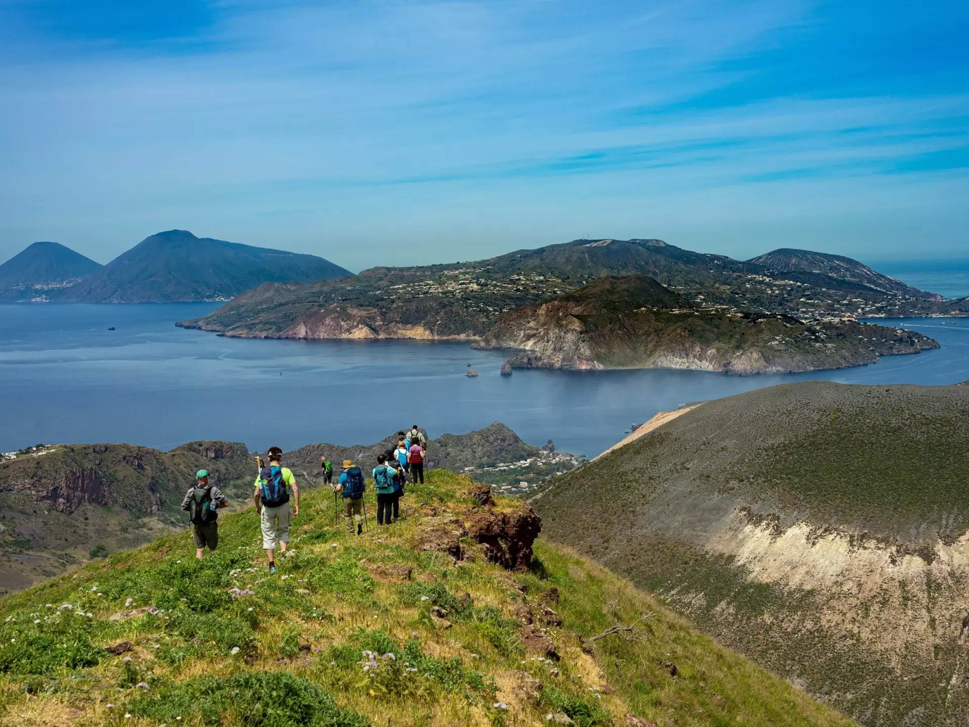
Hiking in spring on Vulcano, one of the Aeolian Islands. Frank Lambert/Shutterstock
Writer
Highlights
Writer Gregor Clark picks 10 hikes across Sicily's volcanoes, coasts and islands.
Watch eruptions on guided Stromboli tours, or tackle iconic Mt Etna's black ash slopes.
Head to Riserva Zingaro for secluded beaches, or Vendicari for bird-watching and flamingos.
Pantalica's Bronze Age tombs and La Rocca above Cefalù reward history-minded hikers.
Lonely Planet may earn a commission from affiliate links on our site. All recommendations and reviews reflect our own independent opinions.
With its volcanic islands, rugged shorelines, brilliant blue-green waters and multilayered history, the gorgeous island of Sicily never fails to excite visitors, particularly those who’ve laced up their hiking boots. Hiking in Sicily is one of the most alluring ways to get to know this unique Italian province. Indeed, hikers may even have an advantage when it comes to getting deep into the island, since many natural and historical attractions here are only accessible on foot.
Appealing walks can be found everywhere in Sicily, from gentle wanders along boardwalks, perfect for family outings with young children, to more challenging routes for experienced hikers. The slow-paced Aeolian and Egadi Islands are especially compelling hiking destinations, thanks to their abundant scenic splendor and minimal vehicle traffic.
To avoid heat, crowds and high prices, the best time to hike in Sicily is in spring (April, May and June) or early autumn (September and October). Plan your trails with our pick of the island's best hikes.
1. Stromboli
Best hike for volcanic action
Distance: 8km
Estimated time to complete: 4 hours and 30 minutes
Level of difficulty: moderate
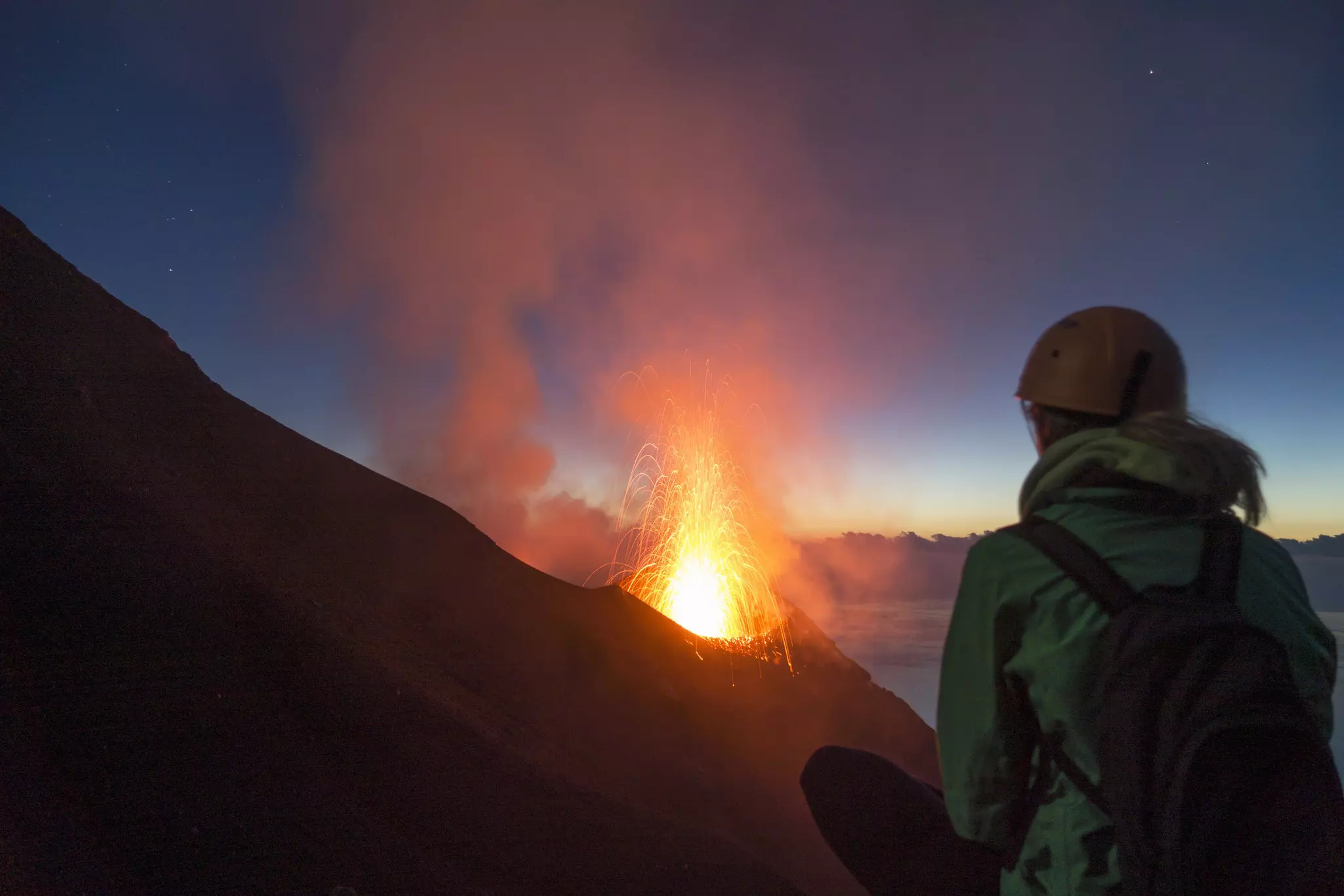
For sheer excitement, nothing compares to Stromboli. Sicily’s showiest volcanic island has been lighting up the Mediterranean for millennia, spewing out regular showers of red-hot rock since at least the age of Odysseus.
Following Stromboli’s last major eruption in 2019, access to the 924m summit has been indefinitely suspended for safety’s sake, but hikers can still enjoy spectacular views from observation points overlooking the Sciara del Fuoco, a jet-black lava scar that runs down Stromboli’s northern flank. Unaccompanied hikers are allowed to climb to 290m; for the best views, join one of the guided sunset tours that depart from Stromboli village near the hydrofoil dock.
Tours begin with a moderate 90-minute trek across the volcano’s flanks to an observation point at 400m. Groups linger at the Sciara del Fuoco for roughly an hour and a half, observing eruptions that typically occur every 20 minutes or so, becoming more vividly visible as the sky darkens. Expect a loud belly-roar as gases force hot magma into the air. After particularly strong eruptions, you can see red-hot rocks tumbling down the seemingly endless slope and splashing into the sea. For best viewing, come on a still evening, when the livid Sciara and exploding cone are particularly dramatic.
Planning tip: Sunset tours are extremely popular; book ahead with reputable agencies such as Magmatrek, Stromboli Adventures or Il Vulcano a Piedi.
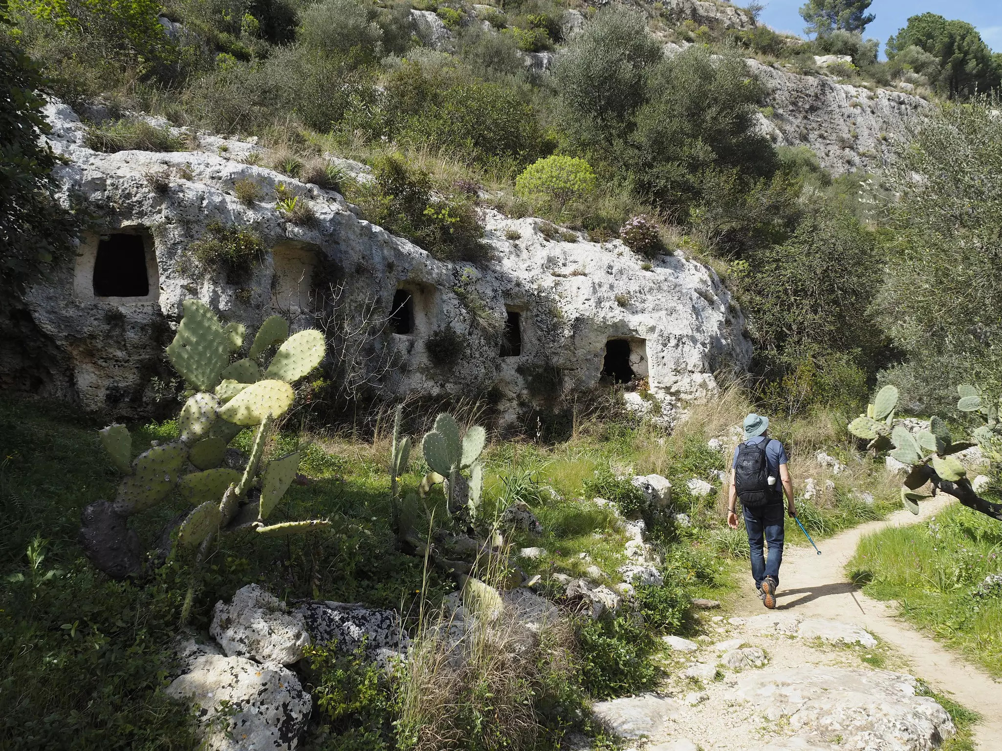
2. Pantalica
Best hike for history
Distance: 12km
Estimated time to complete: 4 hours
Level of difficulty: moderate
Honeycombed into the cliff faces of southeastern Sicily, the ancient tombs of Pantalica form Italy’s most important Iron and Bronze Age necropolis – and they’re a spectacle best appreciated on foot. This engaging loop weaves past dozens of stone-carved burial chambers while exploring the lush Anapo and Calcinara river gorges.
Follow signs for the Necropoli di Filiporto, where eerie openings peer like eyes from limestone escarpments. Stunning views of the cliff-framed Anapo Valley unfold as the trail descends to meet a disused riverside railway bed, then follows the tree-shaded valley floor past citrus orchards, through tunnels and over bridges.
After an hour in the valley, you’ll cross the Anapo on stepping stones, following signs for Saramenzana. Climb to Pantalica’s eastern entrance station, where a gate opens onto a narrower path flanked by rock faces pockmarked with more stone-cut tombs. Just beyond a sign for the Grotta dei Pipistrelli (Bat Cave), a gradual descent leads to pools along the Fiume Calcinara. Cool your toes here, then cross the river and loop back to your starting point via the signposted dirt road.
Planning tip: You’ll find the trailhead at the Anaktoron parking area, 11km east of Ferla. Alternatively, start this hike from the park’s eastern entrance, near Sortino.
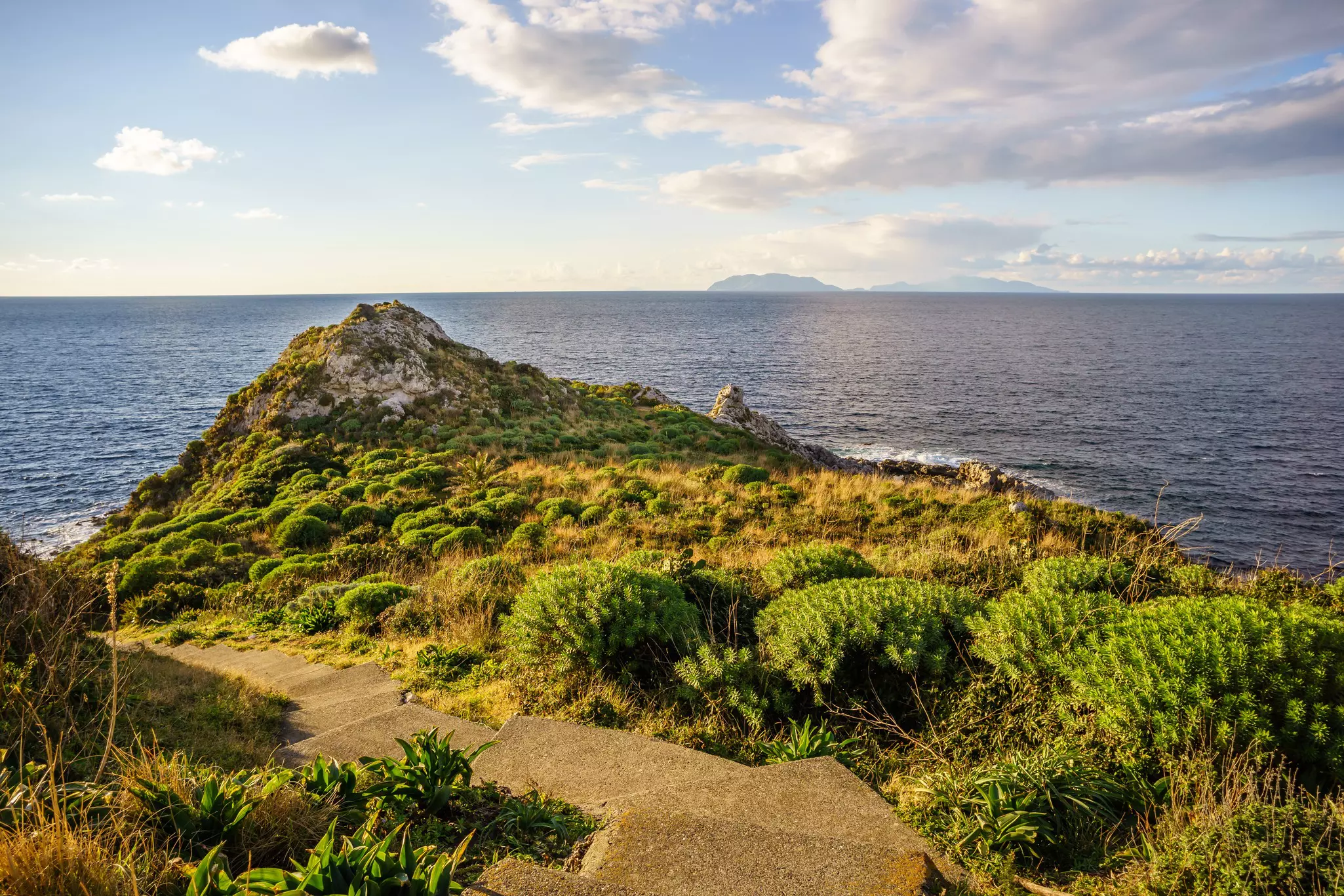
3. Capo Milazzo
Best hike for families
Distance: 3km
Estimated time to complete: 1 hour
Level of difficulty: easy
You couldn’t ask for a more scenic hike than this easy, family-friendly jaunt around the hook-shaped Capo Milazzo peninsula north of Milazzo. The trail initially passes through a level landscape of olive groves, cactus and stone walls before beginning a steady descent toward the surging sea.
The views get truly dreamy near the peninsula’s northern tip, where you’ll find a lighthouse and the Piscina di Venere, a rock-fringed natural pool that’s ideal for a swim. Loop back along the peninsula’s western shore, stopping en route to visit the cactus-covered ruins of the 13th-century Santuario Rupestre di San Antonio da Padova.
Planning tip: Drive or take a local bus to the trailhead, 6km north of Milazzo at Santuario di Sant’Antonio.
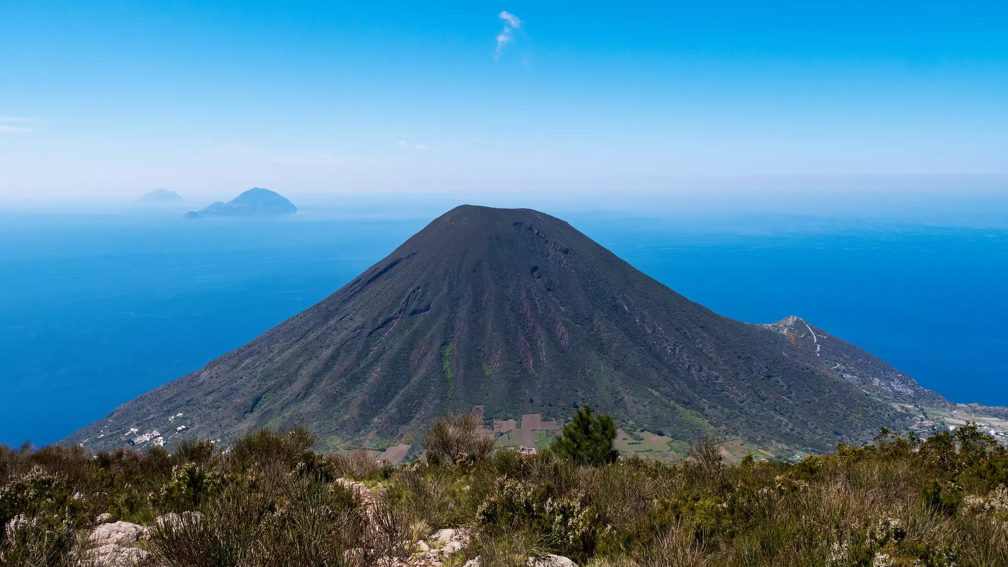
4. Monte Fossa delle Felci, Salina
Best hike for island panoramas
Distance: 4km
Estimated time to complete: 3 hours
Level of difficulty: moderate to challenging
Salina is the greenest island in Sicily’s Aeolian archipelago, and is dotted with wineries that produce the region’s renowned Malvasia vintage. For sweeping views of the vineyards and the surrounding seascape, climb Salina’s highest peak, Monte Fossa delle Felci (962m).
The ancient Greeks dubbed this island Didyme (the twins) thanks to its verdant pair of dormant volcanoes. Starting in the valley separating the two, this trail switchbacks steeply up the mountainside through pine and chestnut woodlands and fields of ferns, all the way to the top. Along the way, you’ll see plenty of colorful flora, including wild violets and asparagus.
The final 100m stretch to the summit is tough, but the reward is ample, with sweeping views of Salina’s shapely second cone, 860m Monte Porri, backed to the west by the distant volcanic islands of Filicudi and Alicudi. From the southeast ridge, you can gaze over the Lingua salt lagoon and over to Lipari and Vulcano.
Planning tip: Free parking is available at the trailhead, behind the imposing 19th-century Santuario della Madonna del Terzito in Valdichiesa.
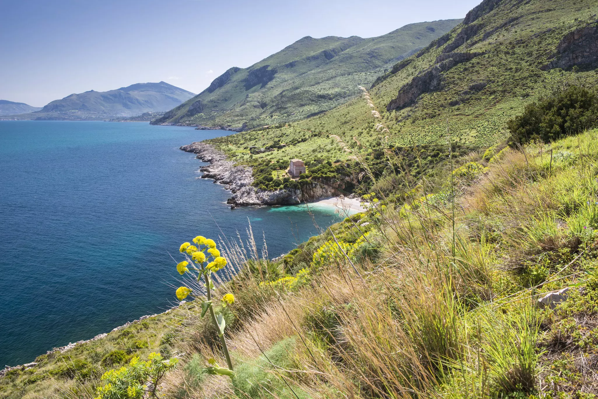
5. Riserva Naturale dello Zingaro
Best hike for beaches
Distance: 14km
Estimated time to complete: 5 hours
Level of difficulty: moderate
Spanning a sinuous series of coves and steep headlands 1 hour west of Palermo, the Riserva Naturale dello Zingaro was established as Sicily’s first nature reserve in 1981, after local protests canceled construction of a controversial highway that would have bisected this spectacular shoreline. The result: one of Sicily’s best spots for walking, with the would-be highway converted into a car-free trail that snakes between bluffs and secluded beaches.
Some 40 bird species (including rare Bonelli's eagles) and 700 species of flora can be spotted here. A visitor center and several small museums celebrate the area’s traditional farming and tuna fishing economy.
Planning tip: The trail is most easily hiked as a simple out-and-back from the park’s southern entrance, 2km north of the pretty hamlet of Scopello. Maps and parking are available at the trailhead.
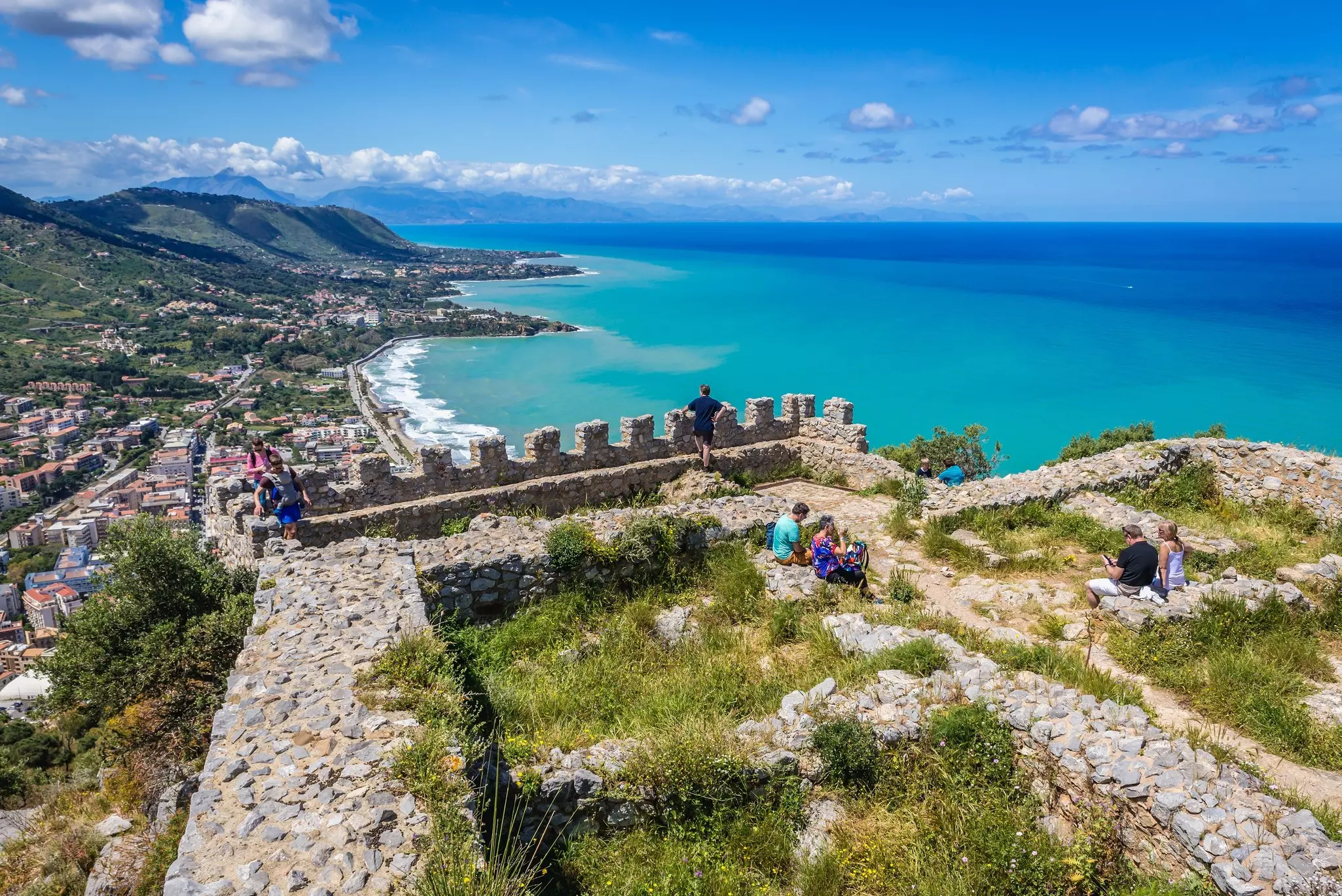
6. La Rocca, Cefalù
Best train-accessible hike
Distance: 3km
Estimated time to complete: 1 hour and 30 minutes
Level of difficulty: moderate
Towering high above Cefalù's sandy beach and Arab-Norman cathedral, the craggy outcrop of La Rocca makes an exhilarating short day hike. The 45-minute climb to the vertiginous 270m summit follows the Salita Saraceni, a winding stone staircase. You’ll pass through three tiers of city walls before leveling off near the midway point on a rock-strewn upland shelf. Catch your breath here at the ruined 4th-century-BCE Tempio di Diana and enjoy the dramatic bird’s-eye perspectives over the cathedral’s honey-colored towers.
From here, it’s another steep slog to the summit. Crowning the hilltop is a ruined 11th-century Norman castle, superimposed on a 9th-century Arab citadel, backed by 360-degree panoramas of the Madonie Mountains and the Tyrrhenian Sea. The windswept surrounding terrain appears a suitable home for the race of giants that are said to have been Sicily’s first inhabitants.
Planning tip: Arriving by train is advisable, as parking in Cefalù’s city center is notoriously challenging. Begin the climb along Salita Saraceni off Piazza Garibaldi, a 10-minute walk from the station.
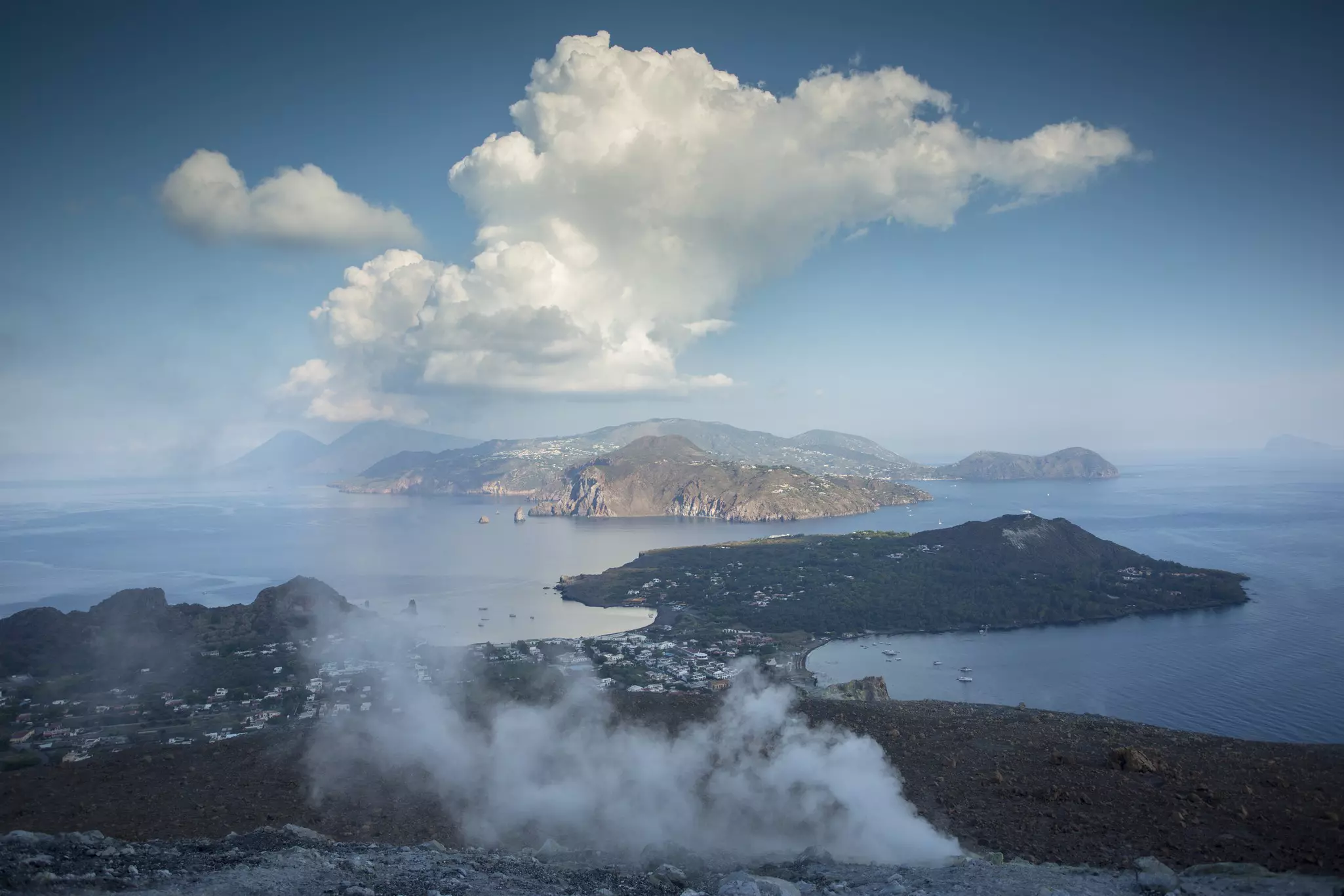
7. Fossa di Vulcano
Best hike for volcanic crater views
Distance: 7km
Estimated time to complete: 2 hours
Level of difficulty: moderate
Volcano hikes don’t get much more satisfying than the gradual climb up 391m Fossa di Vulcano, the smoldering grayish-orange peak that dominates the Aeolian island of Vulcano. Belching out a steady stream of noxious sulfurous fumes, the crater was mythologized by the ancient Romans as Vulcan’s Forge.
Start early if possible, and bring a hat, sunscreen and water. It’s a 30-minute to 1-hour climb to the lowest point of the volcano’s rim (290m), where you’ll be rewarded with fine views of the steaming crater encrusted with red and yellow crystals. It’s well worth lingering up top and climbing another 15 minutes around to the southern rim. From here, you’ll enjoy stunning views of the remaining six Aeolian Islands aligned symmetrically on the horizon, with the gaping crater in the foreground.
Planning tip: From Vulcano’s hydrofoil dock, follow the signs south along Strada Provinciale, then turn left onto the zigzagging gravel track that leads to the summit.
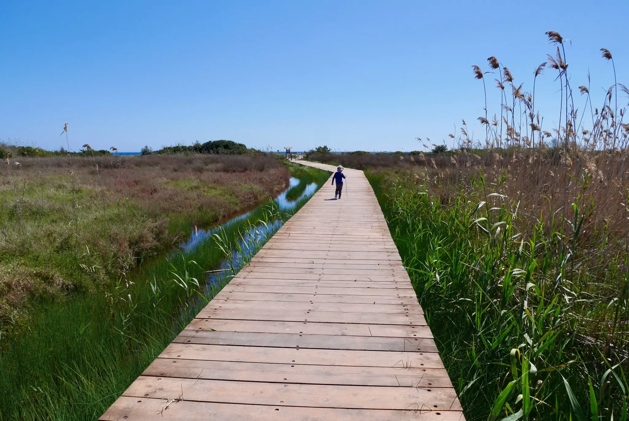
8. Oasi Faunistica di Vendicari
Best hike for bird-watching
Distance: 8km
Estimated time to complete: 3 hours
Level of difficulty: easy
One of Sicily’s easiest and most rewarding coastal walks runs through this bird-watcher’s paradise south of Syracuse. From the reserve’s main entrance, the trail follows raised boardwalks through coastal marshes filled at various times with flamingos, cranes, storks, ospreys, and dozens of other migratory bird species.
Nearing the sea, you’ll come upon the photogenic remains of a historic 18th-century tuna-processing plant and a Swabian defensive tower designed to repel pirate attacks. Continue north along the shoreline to reach Spiaggia Calamosche, a pretty strip of sand lapped by turquoise waters between two jutting headlands. The swimming here is excellent.
Planning tip: The trailhead parking area is signposted off the SP19, about 45km south of Syracuse.
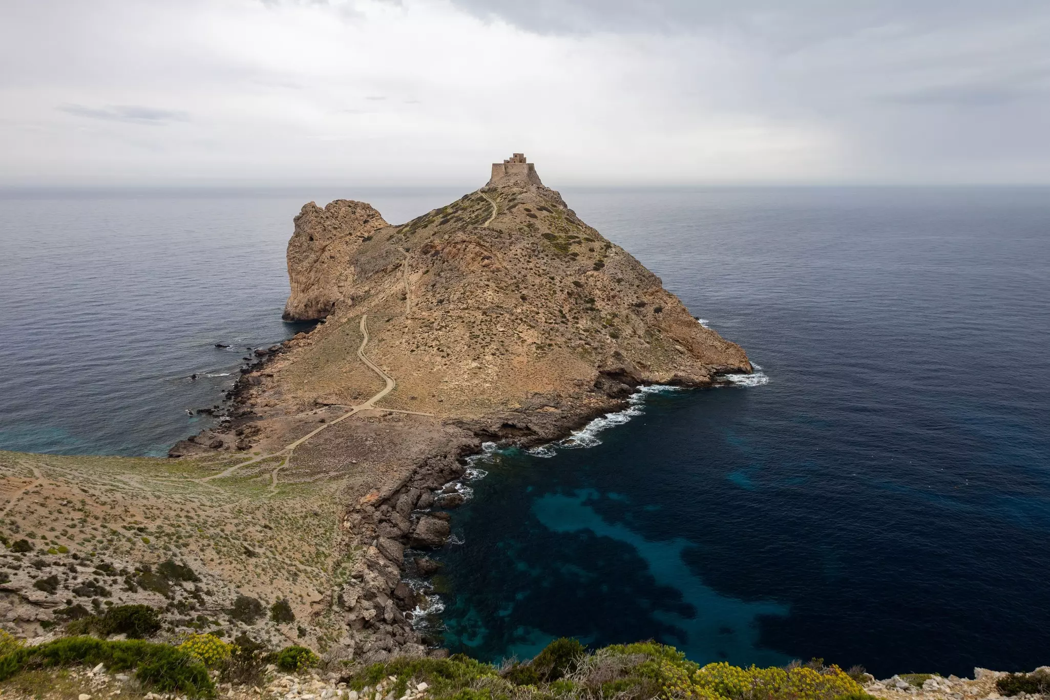
9. Punta Troia
Best hike for getting away from it all
Distance: 8km
Estimated time to complete: 3 hours
Level of difficulty: moderate
An 1 hour and 15 minutes west of Trapani, the tranquil island of Marettimo is an attractive off-the-beaten-track destination for hiking. Hydrofoils dock at the island’s main village, a labyrinth of whitewashed houses surrounded by iridescent turquoise and ultramarine waters. From the port, a network of beautifully maintained, well-marked trails fan out around the island.
Especially scenic is the trail (its trailhead is along the waterfront just north of the hydrofoil dock) that winds north along high bluffs to the precipitously perched Castello di Punta Troia, a 12th-century Norman castle built atop an earlier Saracen watchtower on a lonely promontory at Marettimo’s northeastern tip. Not far from here, in 241 BCE, the Romans and Carthaginians once fought the decisive battle of the First Punic War. These days, however, it’s about as peaceful a spot as you could wish for.
Planning tip: Hydrofoils from Trapani to Marettimo make intermediate stops at the beautiful neighboring islands of Favignana and Levanzo; consider stopping over for an extended Egadi Islands visit.

10. Mt Etna
Sicily's iconic volcano hike
Distance: varies
Estimated time to complete: varies
Level of difficulty: varies
The largest active volcano in Europe and Italy’s highest mountain south of the Alps, 3369m-tall Mt Etna is a moveable landscape. Overnight, summit craters can change in height, and walking trails can disappear under new lava flows. The wind and/or burning sun can be ferocious, and temperatures can fall below freezing.
It is forbidden to go above 2500m without an authorized guide. When volcanic activity allows, treks with a guide up to 3300m raise the curtain on a lunar landscape of black ash slopes and rocky swathes of ancient lava flows. Picking up nuggets of still-warm lava and scraping away ash to uncover last winter's snow beneath are just some of the unique thrills to be experienced on a hike on Etna's slopes.
Mt Etna's southern slope (Etna Sud) is the most accessible and easiest to access from Catania, 30km south. Families and inexperienced hikers keen to get a taster can park by Rifugio Sapienza and explore slopes here around 2000m. This is also where to catch the Funivia dell'Etna cable car up over Etna's crater-covered lateral slopes to the 2500m-high cafe at Montagnola. The quieter northern slope (Etna Nord) is the closest starting point for hikes from Taormina, 50km northeast.
Planning tip: Allow at least 5 hours for a guided hike to the summit. Recommended tour companies include Gruppo Guide Alpine Etna Sud and Go Etna. Etna Freedom runs sunset tours in 4WD vehicles with short walking distances.
Take your Sicily trip with Lonely Planet Journeys
Time to book that trip to Sicily
Lonely Planet Journeys takes you there with fully customizable trips to top destinations – all crafted by our local experts.

