Jul 23, 20259 min read
9 of the best things to do in and around Akureyri, IcelandApr 15, 2019
6 MIN READ

Writer
Writer
Lonely Planet may earn a commission from affiliate links on our site. All recommendations and reviews reflect our own independent opinions.
Crashing waves. Lounging seals. Driftwood- and seabird-dotted shores. Rugged, snow-topped peaks. Colourful fishing towns. To really get off the tourist trail in Iceland and make your adventure your own, head for the Arctic Coast Way (Norðurstrandarleið). Launched in June 2019, this extraordinary journey – Iceland’s first official touring route – traces 900km of untouched and remote coastline and is your chance to experience captivating extremes, heart-pounding elemental drama and tranquil escapes from modern life, all with welcoming villages along the way.
The route from Hvammstangi in the west to Bakkafjörður in the east includes six peninsulas on which black beaches and majestic cliffs alternate with glacial river deltas and fjords along awe-inspiring mountain ranges. A clutch of teeny, unforgettable islands with windswept hamlets feel even more remote, and one, Grímsey, straddles the Arctic Circle. From saga settlements to whale watching meccas, each of the small towns on the route offers insights into life at the top of the world.
Start in sleepy Hvammstangi with its abundant seal colonies which you can tour by boat. Then travel along the serene seafront gravel road (Route 711), which winds for 82km around the softly undulating hills of the Vatnsnes Peninsula. You’d never know from the peacefulness here today that this was the site of one of Iceland’s most notorious crimes, immortalised in the novel Burial Rites by Hannah Kent. After you’ve rounded the tip of the peninsula and are heading south again, explore the striking 15m-high sea stack Hvítserkur. According to local lore, Hvítserkur was a troll who tried to ruin the monastery at Þingeyrar but was caught out in the sunrise. A group of seals can often be spotted here, enjoying the sun a lot more than the troll did.
Lush Skagafjörður has plenty of strings to its bow: horse breeding (and riding), wild landscapes, historical remains and adrenaline-infused activities, like white water rafting and snowboarding, make it one of Iceland's most fabulous under-the-radar spots. Just north of Sauðárkrókur, the area’s main town, Skagafjörður’s western edge is a stretch of gorgeously silent coast draped with scenic mountains. Tindastóll, the most prominent peak, has a geothermal area at its northern end where you’ll find the famous waterfront bathing pool known as Grettislaug. Just offshore, guarding the mouth of Skagafjörður, are the uninhabited islands of Drangey and Málmey, both tranquil havens for nesting seabirds. Summertime boat tours of dramatic Drangey depart from the small harbour beside Grettislaug.
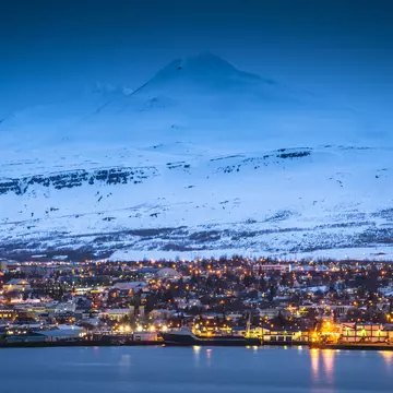
Tröllaskagi (Troll Peninsula), stretching between Skagafjörður and Eyjafjörður, is a land of enormous snow-capped mountains. The deep valleys between the crags are home to some of the best fishing rivers in Iceland. Start at tranquil fishing village Hofsós and its spectacular fjord-facing swimming pool and hot-pot. If you can tear yourself away, further along Siglufjörður (or Sigló, as locals call it) perches on a sparkling waterfront backed by one of those steep mountains. At one time over 10,000 workers lived here, unloading fishing boats and gutting and salting the fish. Tröllaskagi is also a prime spot for winter sports, including heli-skiing.
Akureyri, Iceland’s second largest city, sits on the longest fjord in Iceland, Eyjafjörður – you’ll often spot whales breaching and blowing in the glittering waters here. In addition to visiting lively Akureyri itself, the hamlets around the fjord make for fantastic seafood stops and conversations with locals. While ferries run frequently to the small island of Hrísey in the middle of the fjord, perhaps the best-known island on the Arctic Coast Way is even smaller Grímsey. The only bit of Iceland actually on the Arctic Circle, this tiny, tranquil place (just 5 sq km) sits 40km from the mainland and is where birds outnumber humans 10,000 to one. Its sea-battered coastal cliffs and contorted basalt formations make a popular home for dozens of species of seabirds, including scores of puffins, plus the kamikaze Arctic tern. It can be reached by ferry or plane.
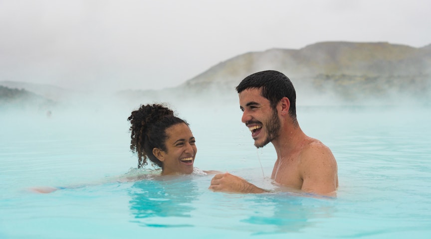
As well as being renowned as Iceland's whale-watching hub, Húsavík, is also worth a stop for its interesting museums (covering whales, exploration and more), quaint houses and historic church, and views of the majestic peaks across the bay. Salt-water spa GeoSea is positioned above it all on the town’s northern point, near the lighthouse. The pools have perfectly warm (38-39°C) geothermally heated saltwater, and the complex’s cafe offers post-dip fjord views. To become one with tranquility, stay over at the thoughtfully decorated, fish-factory-turned-guesthouse Tungulending and enjoy its seasonal dinner specials overlooking the seafront.
Head north from Húsavík along Route 85 and you’ll curve along the coast of the geologically rich Tjörnes Peninsula. Look for fossil-dotted cliffs, now home to seabirds. At Kelduhverfi the land is pocked by grabens (depressions between geological faults) and torn up by fissures. This is a rift point where the Mid-Atlantic Ridge enters the Arctic Ocean – about 12km east of Mánárbakki Museum there's an excellent vantage point with panels giving information on the area’s tectonic activity. The road then drops down to the bird-packed lagoons and deltas of Vestursandur.
At the northern end of Vatnajökull National Park, the Jökulsárgljúfur (pronounced yu-kul-sour-glyoo-vur) portion of the park protects a unique subglacial eruptive ridge and an idyllic canyon called Ásbyrgi. Carved out by the formidable Jökulsá á Fjöllum – Iceland’s second-longest river – lush Ásbyrgi extends in a massive horseshoe shape, measuring 3.5km from north to south and averaging 1km in width. From the car park at the end of the access road, 3.5km south of the visitor centre, several easy short tracks lead through the forest to viewpoints of the canyon, a small bird-friendly pond, and signposts on the area's flora.
From Ásbyrgi, when the roads are open, it’s easy to detour south, off the Arctic Coast Way, to magnificent waterfall Dettifoss (part of the park) and lake Mývatn.
Bypassed by the tourists zooming along the Ring Road, the wild, thinly populated coastal route around Iceland’s most northeasterly peninsulas reaches to within kilometres of the Arctic Circle and is full of enthralling scenery – this is the best of brilliantly unspoilt, untouristed, unhyped Iceland. The little-used coastal road (Route 870) around Melrakkaslétta (Arctic Fox Plain) is unsealed, jolting along for 55km between Kópasker and Raufarhöfn. It’s worth the bumpy ride for the serenity of its unspoilt ponds and marshes dotted with driftwood and rife with bird life. Digress further on tracks to isolated lighthouses on ocean-crushed headlands.
Just north of Raufarhöfn, the surreal stone arches of Arctic Henge create a colossal circle up to 7m in height with sweeping sea views. In town, stop off at the delightfully simple cafe and gallery Kaupfélagið Raufarhöfn for a breakfast buffet, afternoon cake and coffee, or evening meal.
Finish off your exploration with first-rate hiking on Þistilfjörður at Rauðanes headland — turn off between Raufarhöfn (42km) and Þórshöfn (32km). A signposted walking track leads 7km to rippling rock formations – including arches and caves – and secluded beaches, and there's great bird watching (including puffins) too, combining to create the essence of the Arctic Coast Way.
As a brand-new route in Iceland, the Arctic Coast Way is very much a journey in the pioneering spirit – roads in the most remote areas are often simply surfaced with gravel and can be deeply rutted, meaning renting a 4x4 is highly recommended. Infrastructure along the route is currently ok and will no doubt be improving in coming years.
https://shop. lonelyplanet. com/products/iceland-travel-guide-10
Take your Iceland trip with Lonely Planet Journeys
Time to book that trip to Iceland
Lonely Planet Journeys takes you there with fully customizable trips to top destinations – all crafted by our local experts.

Explore related stories