Advertisement
Aboriginal culture and heritage of Kati Thanda-Lake Eyre Basin brought alive in new map

Monique Choy
Oct 5, 2018 • 2 min read

Advertisement
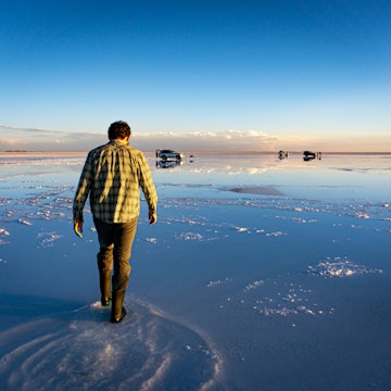
Visible from space as a white stain on a brown continent, the enormous, salt-crusted basin of Kati Thanda–Lake Eyre is the world’s sixth-largest lake and the lowest point in Australia. Most of the time it is an eerily beautiful plain of sparkling salt crystals that stretches from one horizon to the other, a photographer’s dream.
Advertisement
Once every three years or so the lake makes headlines when waters reach the area after a 1000km, painstakingly-slow journey across the outback that takes around two months. The transformation is breathtaking as the area comes to life attracting thousands of birds, fish and aquatic creatures. The lake floods to 1.5m every three years or so, but has only completely filled three times in the last 150 years. The waters soon evaporate in the punishing desert sun, leaving a thick crust of salt on the earth.
The lake can be visited by taking the 620km Oodnadatta Track, one of Australia’s great 4WD adventures, which heads from near Roxby Downs, north of Adelaide, to the highway about 450km south of Alice Springs. This is a true bucket-list adventure through one of the world’s more remote desert landscapes and well worth the journey.
And if you travel this way, make sure you get your hands on a copy of the Lake Eyre Basin Aboriginal Way map. Launched in August 2018 after a 12-year development process, the map is a ground-breaking publication that involved several hundred people in the consultation and production process. It brings together Aboriginal culture and heritage of the Lake Eyre Basin from interviews, oral histories, sacred knowledge, stories and songlines.
Covering an area of 1.2 million square-kilometres across inland Australia — about one-sixth of the continent — the map includes a wealth of detail about First Nations people in the area. It outlines the 71 local tribes/language groups, geographical features, historical trade routes that criss-cross the basin, songlines, stories from the period of first contact with settlers, as well as contemporary Aboriginal culture in the area. Portraits of some of the people involved in the project are also included.
The map is available through the Australian Institute of Aboriginal and Torres Strait Islander Studies. Find out more about the map here.
Advertisement