Advertisement

Death Valley National Park is a place of natural extremes – and extreme beauty © Matt Anderson Photography / Getty Images
Beating out even famously scenic destinations like Alaska and Utah, California is home to more national parks than any other state. The Golden State's 10 national parks showcase the best of the West Coast’s diverse range of landscapes, from the towering redwoods of NorCal, the arid deserts of SoCal, the iconic flora of Joshua Tree and the surreal geologic results of past volcanic eruptions and glacier paths.
From crown jewels of the whole system like Yosemite to remote marine ecosystems like Channel Islands National Park, California's national parks certainly pack a punch. In addition to these officially designated jewels, the National Park Service runs a bevy of other protected places, including wilderness areas, seashores, preserves and such national monuments as Cabrillo and Muir Woods.
If you want to get outside and let nature awe you, the Golden State has what you're looking for. Here are the best national parks in California.
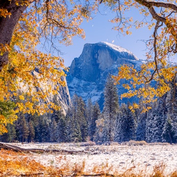
1. Yosemite National Park
Best for sheer grandeur
The centerpiece of the national park system and California’s most popular national park, Yosemite attracted 3.9 million visitors in 2023. Its grandeur is so evocative that it inspires awe even for those who’ve never been. A UNESCO World Heritage site for its exceptional natural beauty, including five of the world's highest waterfalls, it’s also often considered the most beautiful national park in the state.
The park's busiest and most developed part, Yosemite Valley, includes hits like the granite monster El Capitan, the precipitous drop of Bridalveil Fall, the green, often wildflower-strewn valley floor, and, front and center, glorious Half Dome. Other sections of the park burst with giant sequoia groves and an endless array of wilderness trails, and they are no less sublime.
In for the long haul? Load up that pack and connect the dots from the heart of Yosemite to the pinnacle of Mt Whitney, the highest peak in the contiguous USA. A true adventure, the physically demanding 211-mile John Muir Trail goes step by step up and over six Sierra passes topping 11,000ft. Join other blister-footed obsessives crossing chilly rivers and streams as you traverse Yosemite Valley, the roadless backcountry of Kings Canyon and Sequoia and the oxygen-scarce Whitney summit.
Advertisement
Pay homage to the oldest living things on earth. With some trees estimated to be about 4,000 years old, the gnarled and wind-battered stalwarts of the Ancient Bristlecone Pine Forest have certainly stood the test of time. From Independence, wind your way up the high-altitude road to the White Mountains, stopping midway to admire the distant spiked ridge of the Sierra Nevada and the valley below. At the solar-powered Schulman Grove Visitor Center, get your bearings and catch your breath before admiring these wizened survivors.
But there’s more than natural beauty here. Located in Yosemite Valley and built in the 1920s, The Ahwahnee Hotel is a stunning architectural jewel. Its public spaces, including the dining room with its soaring 34ft high ceilings, are a step back in time.
Planning tip: A free shuttle service helps visitors get around the park.

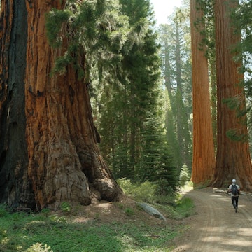
2 & 3. Sequoia and Kings Canyon National Parks
Best for backcountry exploring and ancient trees
Joined by a high-altitude roadway bisecting a national forest and contiguous with several wilderness areas, these two parks offer vast stretches of alpine bliss. Groves of giant sequoias, wildflower-strewn meadows, gushing waterfalls, dramatic gorges and spectacular vistas reveal themselves at nearly every turn.
With a dramatic cleft deeper than the Grand Canyon, rugged Kings Canyon offers true adventure to those who crave seemingly endless verdant trails, rushing streams and gargantuan rock formations. The camping, backcountry exploring and climbing here are all superb. Neighboring Sequoia National Park gets all the glory, but Kings Canyon also has groves of enormous sequoias and far less trafficked trails. The canyon’s General Grant Grove is home to a sequoia nicknamed General Grant, the second-largest tree in the world.
Peaks more than 14,000ft high make up other parts of the park, most designated wilderness. Still, Kings Canyon Scenic Byway (Hwy 180; only open end of April to October) twists and bends through some of the most dramatic scenery in California, making the natural bounty accessible to all (all who drive with confidence, that is). The Big Stump Entrance, near Grant Grove Village, is the park's only entrance station.
As if all that weren't enough, picture unzipping your tent flap and crawling out into a "front yard" of trees as high as a 20-story building and as old as the Bible: Welcome to Sequoia National Park. Brew some coffee as you plan your day of adventures in this extraordinary place, with its soul-sustaining forests and gigantic peaks soaring above 12,000ft.
Choose to gaze at dagger-sized stalactites in a 100,000-year-old cave, view the largest living tree on earth, climb 350 steps to a granite dome with soaring views of the snow-capped Great Western Divide or drive through a hole in a 2,000-year-old log. All that before you've even walked a trail – where the wild scenes (and brief encounters with black bears) will give you goosebumps, charging waterfalls will leave you awestruck and epic overnight backpacking trips will lead you to deserted lakes and idyllic backcountry camps.

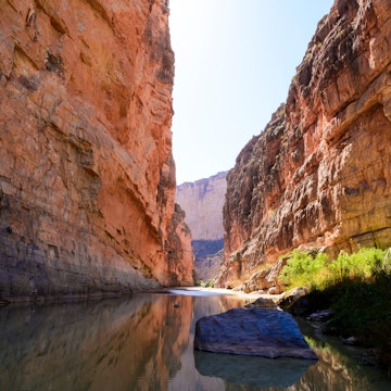
4. Death Valley National Park
Best for natural extremes
The very name evokes all that is harsh, hot and hellish –a punishing, barren and lifeless place of Old Testament severity. This is a land of superlatives – hottest, driest and lowest – windswept sand dunes, water-sculpted canyons, extinct volcanic craters, palm-shaded oases and plenty of endemic wildlife. Nature truly puts on a lively show in Death Valley.
Furnace Creek is Death Valley's commercial hub, home to the national park visitor center, a gas station, ATM, post office and lodging. There's also a mission-style "town square" with a general store, restaurant, saloon and ice cream and coffee parlor. There’s lodging, gas, a general store, dining, RV and camping options at both Stovepipe Wells Village and Panamint Springs. Places to see around Panamint Springs include the ten beehive-shaped Wildrose Charcoal Kilns built in 1876 for processing silver and lead and Darwin Falls, a spring-fed waterfall. At Stovepipe, cool off in the lodge’s swimming pool.
Planning tip: Park entry permits ($35 per vehicle) are valid for seven days and available from self-service pay stations along the park's access roads and at the visitor center.

5. Lassen Volcanic National Park
Best for otherworldly landscapes
In the summer, the dry, smoldering, treeless terrain within this 106,000-acre national park stands in stunning contrast to the surrounding cool, green conifer forests. In winter, tons of snow limits how far you can travel inside its borders. Still, entering the park from the southwest entrance is like stepping into another world. The lavascape offers a fascinating glimpse into the earth's fiery core. In a fuming display, the terrain is marked by roiling hot springs, steamy mud pots, noxious sulfur vents, fumaroles, lava flows, cinder cones, craters and crater lakes. At 10,463ft, Lassen Peak is the world's largest plug-dome volcano.
Centuries ago, this was a summer encampment and meeting point for Indigenous tribes such as the Atsugewi, Yana, Yahi and Maidu, who hunted deer and gathered plants for basket making. Now their descendants work with the park to educate visitors about their ancient history, traditions and contemporary culture.
Lassen has 150 miles of hiking trails, including a 17-mile section of the Pacific Crest Trail. Experienced hikers can attack the Lassen Peak Trail, whose 5-mile round trip takes at least four-and-a-half hours; the first 1.3-mile stretch, up to the Grandview viewpoint, is suitable for families. The 360-degree view from the top is stunning, even if the weather is a bit hazy.
Near the Kohm Yah-mah-nee Visitor Center, a gentler 2.3-mile trail leads through meadows and forest to Mill Creek Falls. Further north on Hwy 89, note the roadside sulfur works with its bubbling mud pots, hissing steam vent, fountains and fumaroles. The moderate 1.5-mile Bumpass Hell trail and boardwalk lead to an active geothermal area with bizarrely colored pools and billowing clouds of steam.

Advertisement
6. Pinnacles National Park
Best for condor sightings
A study in geological drama, this park's craggy monoliths, sheer-walled canyons and rambling caves are the result of millions of years of erosion. In addition to hiking and rock climbing, the park's biggest attractions are its two talus caves. Balconies Cave is always open for exploration, while Bear Gulch Cove is generally closed from mid–May to mid–July, when the resident colony of Townsend's big-eared bats raises their offspring.
The park's namesake spires form a natural barrier bisecting the park. For the west entrance, exit Hwy 101 at Soledad and follow Hwy 146 northeast for 14 miles; the east entrance is accessed via Hwy 25 from Hollister and Hwy 146. There are visitor centers on both sides. No road connects the two sides of the park, though you can hike across in about an hour. While in the park, watch for endangered California condors circling above.
Planning tip: Pinnacles are best visited during spring or fall since the summer heat can get extreme.

7. Joshua Tree National Park
Best for hypnotic desert vistas
As if from the pages of a Dr Seuss book, whimsical-looking Joshua trees welcome visitors to this 794,000-acre park at the convergence of the Colorado and Mojave Deserts. Rock climbers know "JT" as the best place to climb in California; scrambling up, down and around the giant boulders can be fun for all. Hikers seek out hidden, shady, desert-fan-palm oases fed by natural springs, while mountain bikers are entranced by the desert views. It's also a great place to camp.
Originally named the humwichawa by the Cahuilla Nation, these unusual trees, a type of yucca, were often used to make rope, baskets and other clothing. When the Mormon settlers came along, they dubbed it the Joshua tree because the branches stretching toward heaven reminded them of the biblical prophet Joshua pointing the way to the promised land. In spring, the trees send up a huge, single, cream-colored flower, while the octopus-like tentacles of the ocotillo cactus shoot out crimson flowers. The mystical quality of this stark, boulder-strewn landscape has inspired many artists, including U2, who spent time here while recording their 1987 album The Joshua Tree. Unless you're day-tripping from Palm Springs, base yourself in the desert communities linked by 29 Palms Hwy/Hwy 62 along the park's northern perimeter.
Joshua Tree, a small community of just over 6,000, serves as a national park hub and has a visitor’s center for the area. If you love old Westerns from the 1940s and 50s, Pioneertown is worth a stop. Designed to look like the 1880s, it’s actually a much newer creation that was developed as a film and TV set.

8. Redwood National Park
Best for looking up
This park is the southernmost of a patchwork of state and federally administered lands under the umbrella of Redwood National and State Parks. Pick up a map at the visitor center and check out the many hiking options. A few miles north along Hwy 101, a trip inland on Bald Hills Rd leads to Lady Bird Johnson Grove, with its 1.5-mile, kid-friendly loop trail. Or enjoy the secluded serenity of Tall Trees Grove where, as the name implies, you’ll find the park’s tallest trees.
To protect Tall Trees Grove, the number of vehicles allowed per day is limited. Pick up the free permits at the visitor center in Orick, then choose your hiking options. There’s the challenging half-day trip that’s a 6-mile rumble on an old logging road followed by a moderately strenuous 4.5-mile round-trip hike. Or try either the 1-mile there-and-back or a 2.5-mile loop, accessed from Davidson Rd at Elk Meadow, to Trillium Falls.
Planning tip: Winter brings high waters prompting the removal of footbridges crossing Redwood Creek. Check with park rangers before hitting the trails.

9. Channel Islands National Park
Best for marine life
The four northern islands of the eight Channel Islands – San Miguel, Santa Rosa, Santa Cruz, Anacapa and tiny Santa Barbara to the south – make up the stunning Channel Islands National Park. It brims with tide pools, kelp forests and a multitude of sea caves, including the largest in North America. It’s also home to almost 150 plant and a few animal species all unique to the island. The chain is accessible by boat from Ventura or Oxnard.
Snorkel, dive, swim and kayak among the kelp beds and along the sandy beaches on Anacapa, Santa Cruz and Santa Rosa islands. San Miguel and Santa Barbara abound with colonies of northern elephant seals.
Planning tip: Beautiful any time of year, the islands receive most visitors between June and September. The best times to visit are during the spring wildflower season (April and May) and in September and October when the fog clears. Winters are often stormy but are ideal for whale-watching.
Other National Park Service-designated sites in California

10. Lava Beds National Monument
Best for geology
Perched on a shield volcano, Lava Beds National Monument is a truly remarkable 47,000-acre landscape of geological features – lava flows, craters, cinder cones, spatter cones and amazing lava tubes. More than 800 caves have been found in the monument, all averaging a comfortable 55°F (13°C) no matter the temperature outside. You can spy Indigenous pictographs and petroglyphs in certain corners of the park, too.

11. Point Reyes National Seashore
Best for crashing waves
A rough-hewn beauty, Point Reyes National Seashore boasts marine mammals and birds, along with scores of shipwrecks. Follow Sir Francis Drake Blvd 20 miles west to the point's edge-of-the-world lighthouse, the perfect spot for observing migrating whales in winter.

12. Muir Woods National Monument
Best for a taste of nature near the city
The experience of walking amongst the world's tallest trees can only happen in Northern California and part of southern Oregon. The old-growth redwoods at Muir Woods, just 12 miles north of the Golden Gate Bridge, are the closest redwood stand to San Francisco. For more grandiose redwood forests, travel further north to Mendocino and Humboldt Counties.
Once destined to be felled for a dam, the trees were saved when congressman and naturalist William Kent bought a section of what was then called Redwood Creek. In 1907, he donated 295 acres to the federal government, and a year later, President Theodore Roosevelt made the site a national monument.

13. Devils Postpile National Monument
Best for column-climbing
The most fascinating attraction in Reds Meadow is the surreal volcanic formation of Devils Postpile National Monument. The 60ft curtains of near-vertical, six-sided basalt columns formed when rivers of molten lava slowed, cooled and cracked with perplexing symmetry. This honeycomb design is best appreciated from atop the columns, reached by a short trail, just an easy half-mile hike from the Devils Postpile Ranger Station.
From the monument, a 2.5-mile hike passing through fire-scarred forest leads to the spectacular Rainbow Falls, where the San Joaquin River gushes over a 101ft basalt cliff.
Planning tip: The chances of actually seeing a rainbow forming in the billowing mist are greatest at midday. The falls can also be reached via an easy 1.5-mile walk from the Reds Meadow area, which has a cafe, a store, the Reds Meadow campground and a pack station. Shuttle services run to the Reds Meadow area in season.

14. Mojave National Preserve
Best for utter solitude and serenity
Suppose you're on a quest to reach the middle of nowhere. In that case, there’s no better place than the 1.6-million-acre Mojave National Preserve, a jumble of dunes, Joshua trees, volcanic cinder cones and habitats for bighorn sheep, desert tortoises, jackrabbits and coyotes. Whether you spend an entire day or just a few hours exploring the free preserve, enjoy sights like the giant "humming" dunes, an extinct volcano, a huge Joshua-tree forest and sculptured rock walls. The main visitor center, located in an old railroad depot in Kelso, has information and maps.
Planning tip: Daytime temperatures hover above 100°F (37°C) during summer, and plummet to around 50°F (10°C) in winter, when snowstorms can occur. Spring and fall bring strong winds. Gas isn’t available within the preserve.
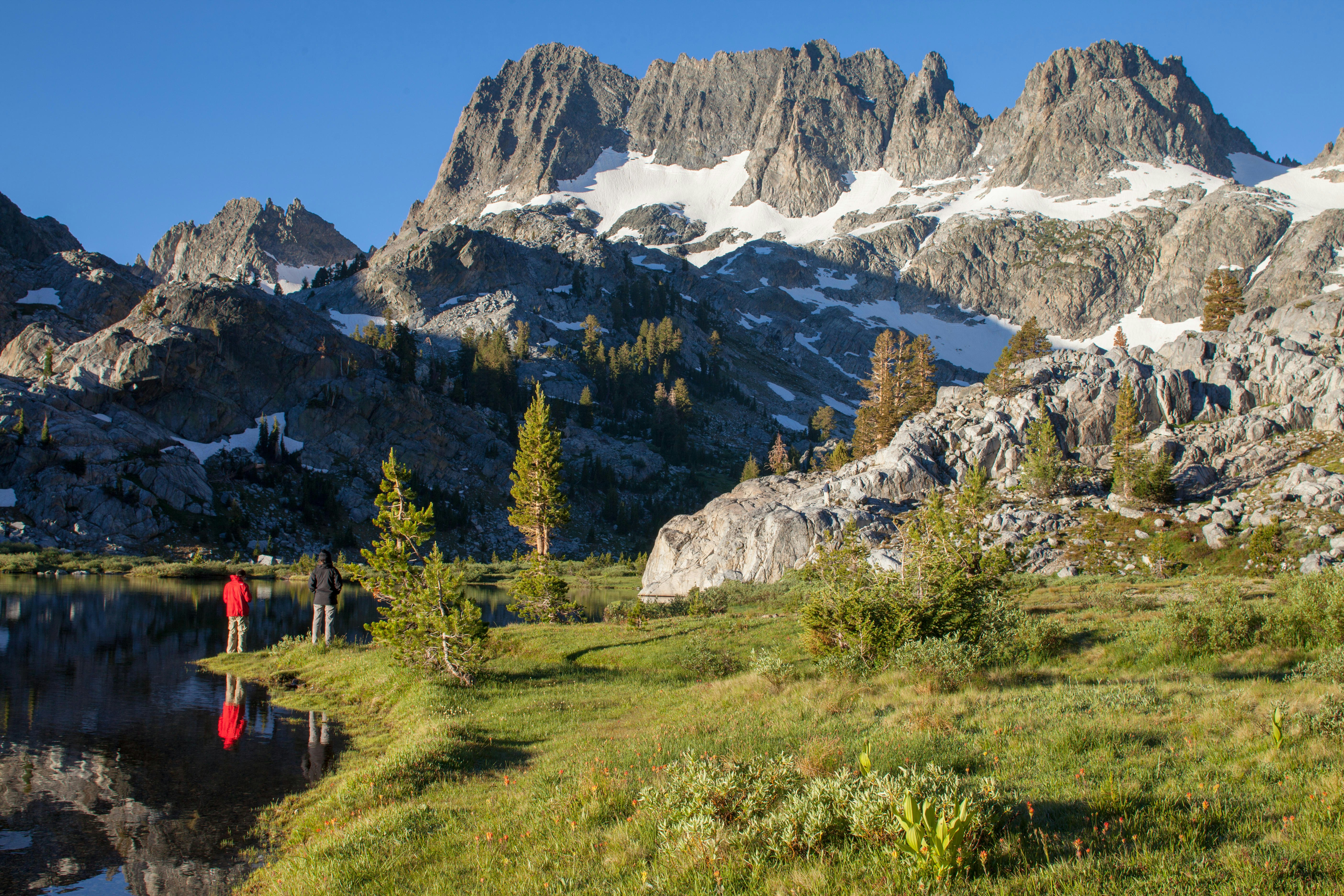
15. Ansel Adams Wilderness Area
Best for alpine scenery
Abutting Yosemite National Park, Mammoth Lakes, June Lake and Inyo National Forest, the lakes, peaks, gorges and glaciers in the Ansel Adams Wilderness Area make Sierra Nevada’s most dramatic alpine destinations.

16. Inyo National Forest
Best for vast forests and high peaks
An enormous region of nearly two million acres of dense forests, high peaks and lakes and nine wilderness areas, Inyo covers a good chunk of California's Eastern Sierra and White Mountains. Encompassing a vast network of trails and campgrounds, there are ranger stations in Lone Pine, Bishop, Mammoth Lakes and Mono Basin. The Inyo National Forest’s 128,000-acre Hoover Wilderness Area is a backcountry paradise dotted with such stunning sights as Virginia Lakes, Lundy Lake and the high peaks bordering Yosemite to the west.
Keep planning your trip to California
Find the best time to visit California’s national parks.
Visit nine of California’s national parks in one epic journey.
Traveling on a budget? Here are tips on how to save money.
Advertisement