
Advertisement

In Canada’s vast wilderness (and it doesn’t get more wild than Tombstone Territorial Park in Yukon), hikes you’ll never forget await. chrisontour84/Shutterstock
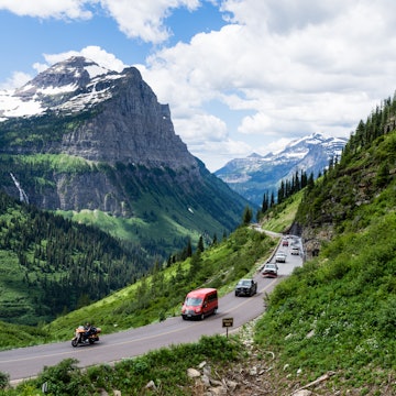
It’s difficult to do justice to Canada’s awe-inspiring landscapes.
Words can never fully capture what you see with your eyes: towering snow-capped mountains, azure lakes and lush evergreen forests filled with fascinating wildlife. And perhaps the best way to take it all in? On your own two feet.
Covering nearly 10 million sq km, Canada was built for adventurous hikers. There are so many gorgeous hiking trails and national parks to explore, you’ll always find a reason to come back, no matter how many hiking holidays you take here.
As you plan your first (or 17th) trip to Canada’s great outdoors, here’s our list of the best hikes in the country, from coast to coast.
1. East Coast Trail, Newfoundland
Best multi-day hike
Distance: 336km round trip
Estimated time to complete: 6 days
Level of difficulty: Easy to challenging
This epic 336km trail, one of the longest in Canada, showcases another bit of the country’s natural beauty with each national historic site, coastal village, forest, cliff and bridge you pass.
Advertisement
The route is divided into 25 wilderness trails – all linked and arranged in a linear fashion. Most people choose a specific trail or two based on their personal comfort levels. The stages range from around 4km to 20km.
It takes around six days of hiking to complete the trail; along the way, you can choose to camp at designated campgrounds or stay at local B&Bs and inns.
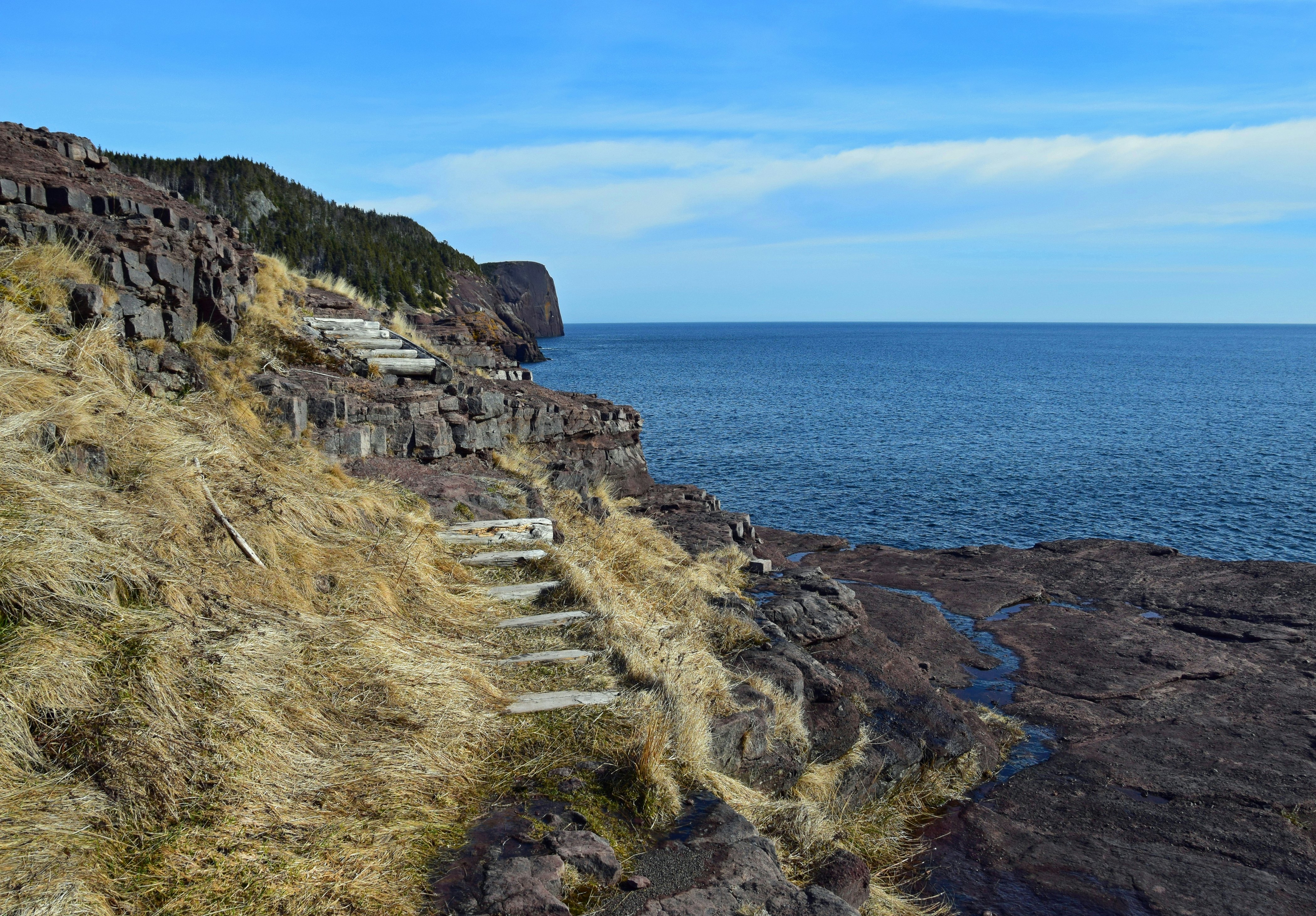
2. Lower Little Harbour Trail, Newfoundland
Best hike for eerie vibes
Distance: 2–3 hours
Estimated time to complete: 1½ hours
Level of difficulty: moderate to challenging
This 4.8km loop takes in just about everything that makes Newfoundland special. Think historic root cellars constructed by early settlers, a natural sea arch, rocky cliffs, scenic stretches of coast, green forests and the remains of a community since abandoned. The empty houses you’ll wander by on parts of this trail give an icy, fingers-on-the-neck vibe.
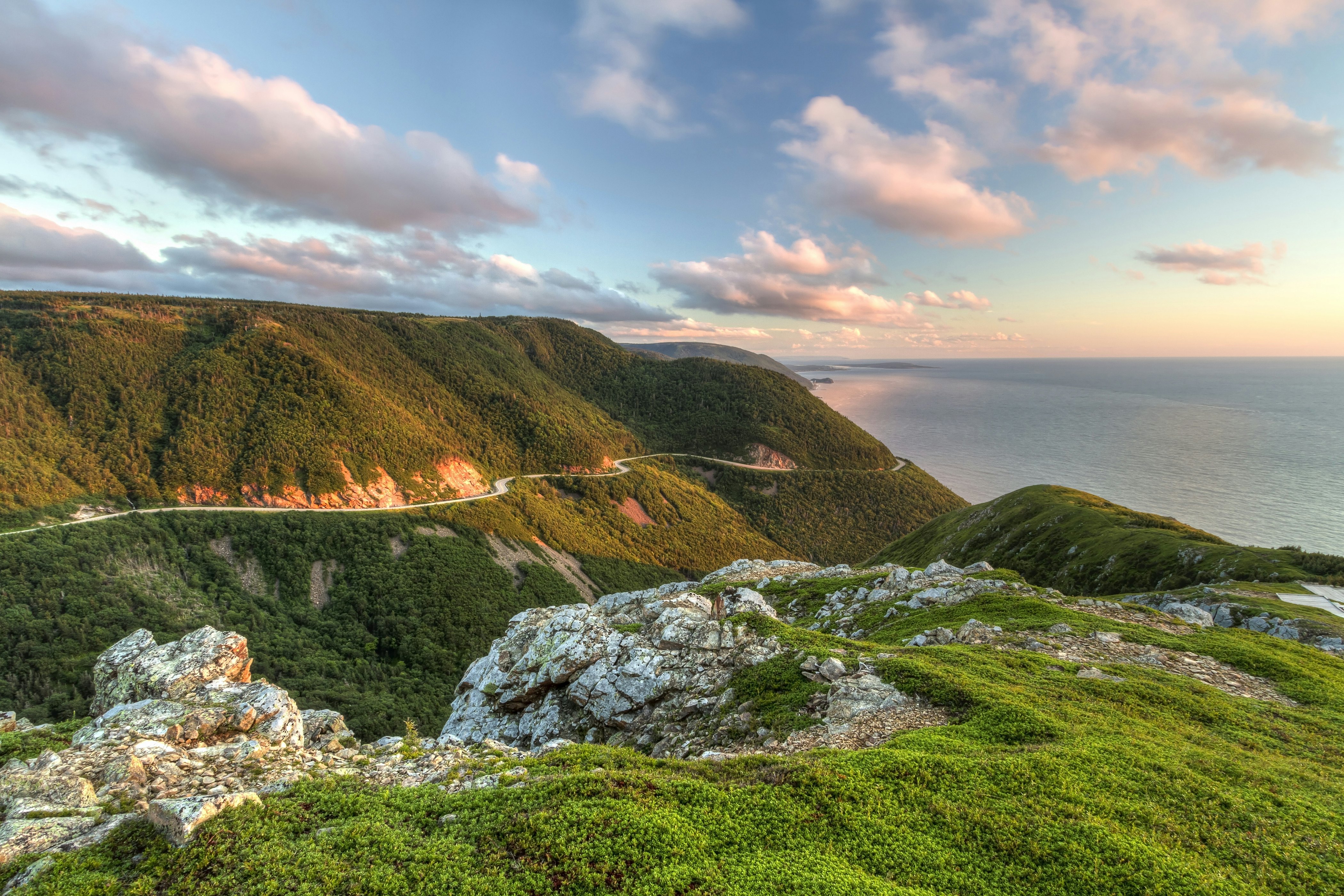
3. Skyline Trail, Nova Scotia
Best hike for water views
Distance: 8.7km (5.4 miles)
Estimated time to complete: 2–3 hours
Level of difficulty: easy
A highlight of Cape Breton Highlands National Park, the Skyline Trail is as dramatic as its dramatic-sounding name suggests. Following a boardwalk that stretches the entire length of the route to protect the area's delicate ecosystems, the hike can be completed as a 7km out-and-back hike, or an 8.7km loop.
If you can ignore the breathtaking views (this is an especially beautiful place to be at sunset), the wildlife spotting opportunities here are major. We’re talking moose, bald eagles, bears and numerous boreal bird species - plus whales offshore.
4. Cape Split, Nova Scotia
Best coastal hike
Distance: 13km (8.1 miles) round trip
Estimated time to complete: 5 hours
Level of difficulty: moderate
Located on a finger of land jutting into the Bay of Fundy, this 13km round-trip trail from Scots Bay takes around five hours to complete. It’s one of the most popular hikes in Nova Scotia, with little elevation change as you pass through a tunnel of forest cover.
The hike ends in a dramatic, windy clearing on cliffs high above the Bay of Fundy, with seabirds nesting below. Wander down to the rocky outcrop at the vertiginous end of the trail to see waves known as tidal rips that flow through a cluster of rock pinnacles. Take time before or after the hike to look for pretty agate stones along the beach at Scots Bay.
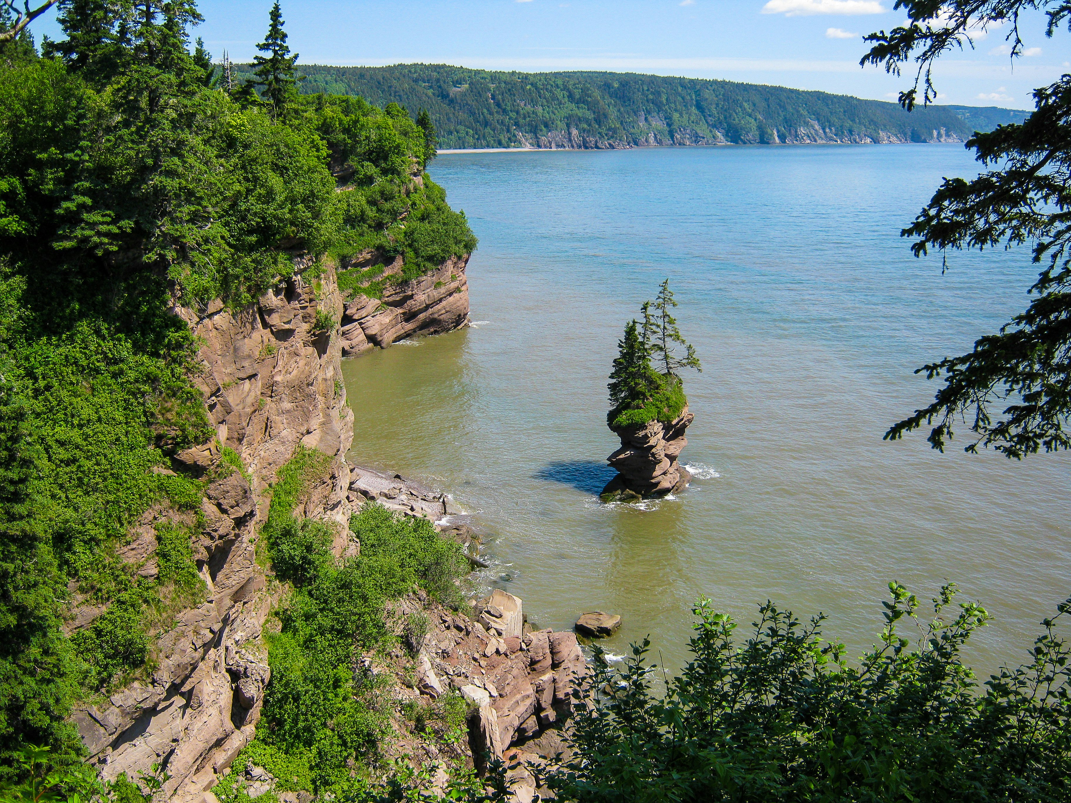
5. Fundy Footpath, New Brunswick
Best hike for experienced wilderness trekkers
Distance: 49.3km (30.6 miles) one way
Estimated time to complete: 4–5 days
Level of difficulty: challenging
A bucket-list itinerary for seasoned hikers, the Fundy Footpath is an incredibly challenging wilderness trail in Fundy National Park in New Brunswick. The trail covers 49.3km of rugged terrain, with steep changes in elevation. It’s backcountry hiking at its best, and though parts of the trail lie within the national park, the route is infrequently maintained.
It can take up to five days to complete the trek, and the route should only be attempted in the warmer months (the risk of hypothermia sets in from mid-October). Refer to the Fundy Hiking Trail Association planning guide if you plan to tackle this once-in-a-lifetime trail, as the route can be incredibly hazardous – and thrilling.
6. Parc d’Environnement Naturel de Sutton, Québec
Best summertime hike
Distance: 80km (49.7 miles)
Estimated time to complete: 2 hours up to several days
Level of difficulty: easy
With two glorious lakes and various mountain ponds for swimming, Sutton Park is prime hiking territory in the summer. In this scenic conservation area in Québec, 80km of trails have been carved through the thickly forested mountains. Trails cover everything from 2-hour loops to multi-day excursions, and backpackers can unfold their tents at three primitive campgrounds.
On holiday weekends and during warm weather, buy your park tickets ahead of time on the Sutton Park website to guarantee entry. This park is a pretty reliable playground year-round, but sometimes icy winter conditions close the trails; check the park website ahead of time for closures.

7. Cup & Saucer Trail, Ontario
Best hike for families
Distance: 9km (5.6 miles) round trip
Estimated time to complete: 15 minutes to 4 hours
Level of difficulty: easy to challenging
Advertisement
Amazing views, interactive adventure experiences and a wide range of possible hike durations (from 15 mins to 4 hours) make this Ontario trail popular with families.
From its origin near the junction of Hwy 540 and Bidwell Rd, around 25km southwest of Little Current, this beautiful trail on the Niagara Escarpment leads to the highest point on Manitoulin Island.
At 351m, hikers are treated to breathtaking views of the crinkled shoreline along the North Channel. Take a shortcut on the way back along the 500m Adventure Trail, which involves descending on rickety wooden ladders and clambering up, over and down massive boulders.
8. Bruce Trail, Ontario
Best hike for fall foliage
Distance: 900km (559 miles) one way
Estimated time to complete: hike durations vary
Level of difficulty: moderate
The Bruce Trail winds along the top of the Niagara Escarpment for a staggering 900km, from Queenston Heights Park on the Niagara Peninsula to Tobermory Harbour on the Bruce Peninsula. The wide, well-maintained path is excellent for hiking during summer, while those armed with cross-country skis put the trail through its paces in winter. Most people tackle the Bruce Trail in short stages.
The best time to hike here is in the fall: Ontario has some of the most vivid fall foliage in the world, and the thick canopy of reds, oranges and yellows is a photographer’s dream. Ontario weekenders love hiking these trails, so be sure to book your parking beforehand. Weekdays are less busy, and you can usually just show up. The Bruce Trail Conservancy has a comprehensive online guide covering how to get passes for the various trailheads.
9. Grey Owl Trail, Saskatchewan
Best hike for birding
Distance: 20km (12.4 miles) one way
Estimated time to complete: 10–12 hours
Level of difficulty: challenging
The Grey Owl Trail offers a serene hike through terrain dotted with wildflowers and patches of marshland, with great birding opportunities and the chance to visit a historic Canadian site in Prince Albert National Park in Saskatchewan.
Most of the trail is under a dense canopy of forest; at the end of the trail, just before you turn back, you can visit Grey Owl’s cabin. This simple structure was formerly the home of the writer and conservation activist Archibald Belaney (aka “Grey Owl”), his partner Anahareo – a member of the Kanienʼkehá:kaor (Mohawk) tribe – and their two pet beavers.
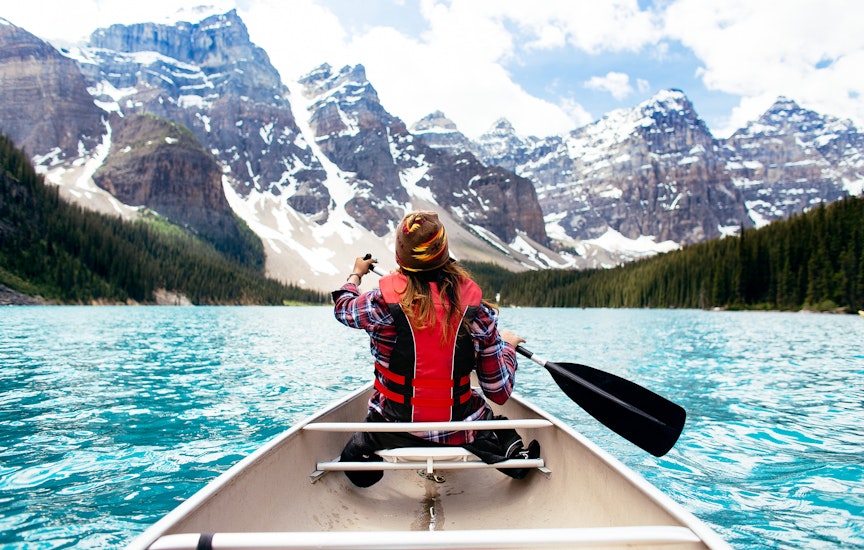
10. Lake Agnes & the Beehives, Alberta
Best iconic Canadian hike
Distance: Lake Agnes round trip: 7km (4.3 miles), Big Beehive round trip: 10km (6.2 miles)
Estimated time to complete: 2–4½ hours
Level of difficulty: moderate
Two compelling attractions make this the most popular hike at Lake Louise in Banff National Park, Alberta. First up is the historic Lake Agnes Teahouse, where hikers have been refueling since 1901. At the 3.4km mark, it’s a supremely atmospheric spot to break for tea, sandwiches and baked goods.
The second wow factor is the phenomenal view over the lake from atop 2270m Big Beehive, the trail's ultimate destination.
Set off early to beat the crowds, and be sure to check out the Canada Parks page beforehand to make sure the roads to the trailhead are open (closures are common in the snowy months).
11. Johnston Canyon & the Inkpots, Alberta
Best popular Canadian hike
Distance: 5km (3.2 miles) round trip
Estimated time to complete: 3–4 hours
Level of difficulty: easy to slightly challenging
After the Lake Louise shoreline, no place in Banff National Park sees as much foot traffic as the wide, paved Johnston Canyon Trail. Such popularity makes total sense once you enter the canyon, where dramatic cliff faces compete for your attention with two gorgeous waterfalls (the Lower and Upper Falls).
The trail to the Lower Falls is around 1.1km in length, and the walk takes about half an hour, while the hike to the Upper Falls is a little more challenging at 2.6km, with a slight increase in elevation. More intrepid hikers can climb to the Inkpots, two colorful natural pools in a high mountain valley.
This area is prone to extreme weather, so be sure to check the Canada Parks Banff website for up-to-date information on any avalanches or flooding.
12. Garibaldi Provincial Park, British Columbia
Best overnight hike
Distance: 25km (15.5 miles) one way
Estimated time to complete: 2 days
Level of difficulty: moderate
With five different trailheads to choose from and 90km of trails at varying degrees of intensity, Garibaldi Provincial Park is a hiker’s fantasy. Named after its towering namesake mountain – 2678m Mt Garibaldi – this area was established as a provincial park in 1927. Accessible via a long day trip from Vancouver and nestled in the nestled in the Coast Mountains of British Columbia, Garibaldi offers plenty of lakes and scenic vistas to keep you busy.
The longest trail is the hike from the Cheakamus Lake parking lot to the Garibaldi Lake parking lot via Helm Creek. The route covers 25km and is best attempted over two days, breaking the trip at the Helm Creek campground. A less ambitious trail of 3km links the Cheakamus Lake Parking lot to Cheakamus Lake.
Always check the British Columbia Parks page for trail closures on the morning of your hike, as volatile weather conditions can cause temporary closure of trails.
13. Wild Pacific Trail, British Columbia
Best informative hike
Distance: 10km (6.2 miles) round trip
Estimated time to complete: 3–4 hours
Level of difficulty: easy to moderate
Where the temperate rainforest comes down to kiss the ocean, this magnificent 10km trail is equally spectacular in sunshine and rain. The route starts with a 2.6km loop that winds past a lighthouse built in 1915 at Amphitrite Point, then progresses northwest as far as the Ancient Cedars loop and the Rocky Bluffs beyond.
The trail is well signposted and fastidiously mapped. To complete the whole trail, you’ll need to follow a couple of interconnecting paths along quiet roads, passing several attractive beaches on the way.
Various information boards provide background on the area’s history and ecological profile. The path is dotted with benches, lookouts and so-called “artist’s loops” with viewing platforms for those taking time to record the scenery.

14. Kinney Lake & Berg Lake Trails, British Columbia
Best scenic hike
Distance: 4.5km (2.8 miles) one way
Estimated time to complete: 2½ hours
Level of difficulty: easy
Situated in stunning Mount Robson Provincial Park, the trailhead for this easy round-trip hike to gorgeous Kinney Lake lies 3km north of the Mt Robson Visitor Centre.
From Kinney Lake, the longer, harder Kinney Lake–to–Berg Lake trail covers 23km, with seven camping areas along the way. Severely damaged by extreme weather in 2021, the backcountry route has reopened – though reservations are now required, and may be made up to four months in advance.
All Berg Lake hikers must check into the Mt Robson Visitor Centre before heading out, so check with the park authorities for the latest information.
15. Canol Heritage Trail, Northwest Territories
Best multi-week hike
Distance: 358km (222 miles) one way
Estimated time to complete: 3–4 weeks
Level of difficulty: challenging
The wild, challenging Canol Heritage Trail runs southwest through the Northwest Territories for 358km, traversing peaks, canyons and barrens until it reaches the Yukon border. Wildlife is abundant, there are numerous deep river crossings, and old Quonset huts provide the only shelter.
The trail was built at enormous monetary and human cost during WWII to transport oil to Whitehorse, the capital of the Yukon Territory (“Canol” is shorthand for “Canadian Oil”). This huge project was abandoned in 1945, with the war nearly over, as cheaper sources of oil were found.
Hiking the whole length of the trail takes three to four weeks; most people arrange food drops along the route. Contact Northwest Territories Tourism for information before you head out, as this is not a hike to be undertaken lightly.
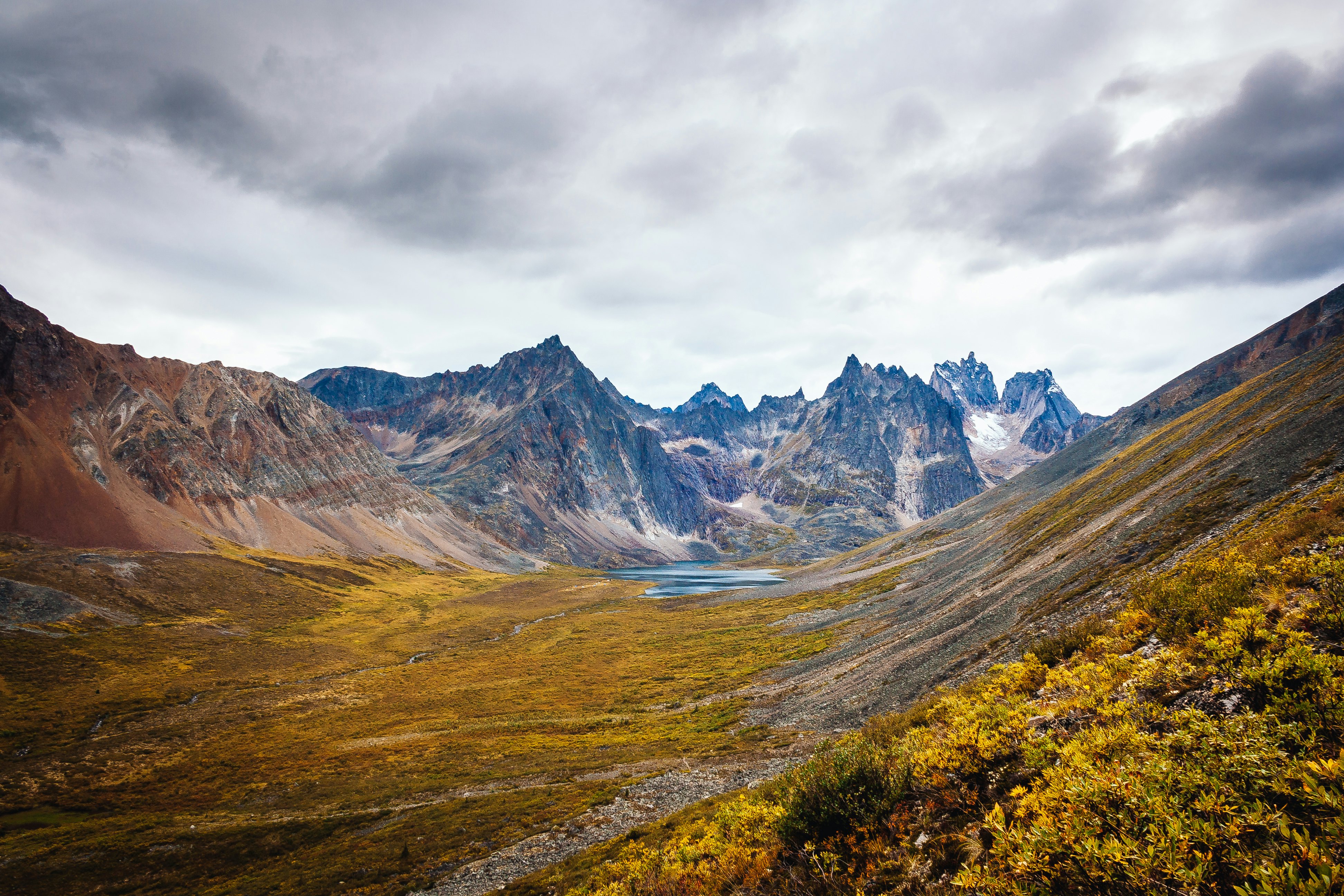
16. Grizzly Lake Trail, Yukon
Best hike for major adventure
Distance: 11km (6.8 miles) round trip
Estimated time to complete: 6 hours
Level of difficulty: challenging
The Grizzly Lake Trail is located in Tombstone Territorial Park in Yukon, accessible via the Dempster Hwy (a dirt road). The views of the Grizzly Valley along the route will linger long in your memory.
This trail can be tackled as a day trip, but if you plan to stay longer and hike other popular trails at Tombstone – for example, adding another 37km on the Divide Lake and Talus Lake trail – you’ll need to stay overnight.
Campers will need a bear-proof food canister – even though the park’s squirrels will be your most persistent pests. Their favorite foods are sweaty backpack straps and the tops of hiking poles, so make sure to pack these away when you camp.
Book hiking passes well in advance, as they sometimes sell out for the entire year by January. This is a challenging hike, so all trekkers need to complete a mandatory backcountry hiking orientation for safety reasons. This applies even if you’re a seasoned hiker.
Advertisement