May 9, 20267 min read
The prettiest places to visit in CanadaMay 6, 2026
8 MIN READ
Writer
Highlights
Writer Brendan Sainsbury maps seven of Canada's best road trips coast to coast.
Drive BC's Sea to Sky Highway for mountains or Alberta's Icefields Parkway for glaciers.
For history, take Newfoundland's Viking Trail; Cabot Trail and Gaspésie Tour reward coast lovers.
Yukon's Klondike Highway traces the gold rush; Ontario's Lake Superior shore stays wild and remote.
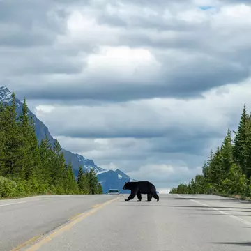
Traffic on the Icefields Parkway, Alberta, Canada. 365 Focus Photography/Shutterstock

Writer
Highlights
Writer Brendan Sainsbury maps seven of Canada's best road trips coast to coast.
Drive BC's Sea to Sky Highway for mountains or Alberta's Icefields Parkway for glaciers.
For history, take Newfoundland's Viking Trail; Cabot Trail and Gaspésie Tour reward coast lovers.
Yukon's Klondike Highway traces the gold rush; Ontario's Lake Superior shore stays wild and remote.
Lonely Planet may earn a commission from affiliate links on our site. All recommendations and reviews reflect our own independent opinions.
In every province and territory in Canada, magnificent journeys by car await. On a road trip in this continent-size country, you might stumble upon massive glaciers, foraging fauna, stormy coastlines and the raw, uncompromising wilderness this place specializes in.
Canadian roads are generally wide and well-maintained, with scrupulously polite drivers. With the huge distances involved, you can often go a long way without seeing a gas station or having options for decent food, especially in the north. Be sure to stock up on supplies when you can, and have emergency gear in your trunk.
Now that you’re fully briefed, get inspired by our list of the seven best road trips in Canada.

Best road trip for families
Start/finish: Vancouver/Whistler
Approximate distance: 121km (75 miles)
From the deluxe, hill-hugging homes of West Vancouver to the neo-Alpine ski village of Whistler, the Sea to Sky Highway delivers along every kilometer. Comprising the most spectacular section of Hwy 99, which runs for 377km (234 miles) from the US border to Cache Creek in British Columbia, the drive traverses the steep-sided slopes of Howe Sound before contouring north through the Coast Mountains to Whistler.
If you can take your eyes off the collage of peaks, forests and fjords, this winding thoroughfare has many worthy stops, especially if you’re up for hiking, climbing or mining history. Horseshoe Bay is the city’s main ferry terminal and the starting point for a tough, rocky hike up to Eagle Bluffs that ends with sweeping views over Vancouver.
Further north, Britannia Beach is a one-time company town whose former mining facility – now a museum and national historic site – concertinas down a steep hill. The small but growing town of Squamish is an obligatory stop for refueling (get gas at the local Shell station and coffee at the funky Zephyr Cafe) and a ride on the finest gondola in BC.
Planning tip: Locals fondly recommend an extended stop at Function Junction a few kilometers south of Whistler. Hike through the forest to a 1950s train wreck that has been turned into an inspirational art project and buy lunch at peerless Purebread, possibly the finest purveyor of baked goods this side of Paris.
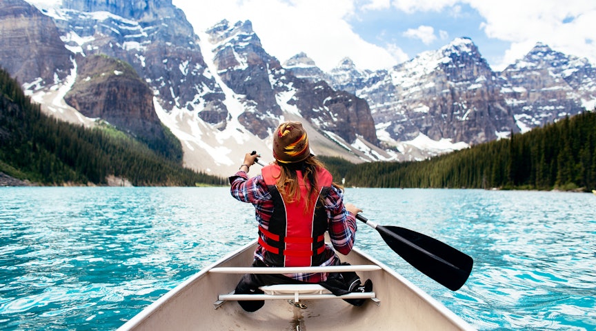
Best road trip for mountains and glaciers
Start/finish: Lake Louise/Jasper
Approximate distance: 230km (143 miles)
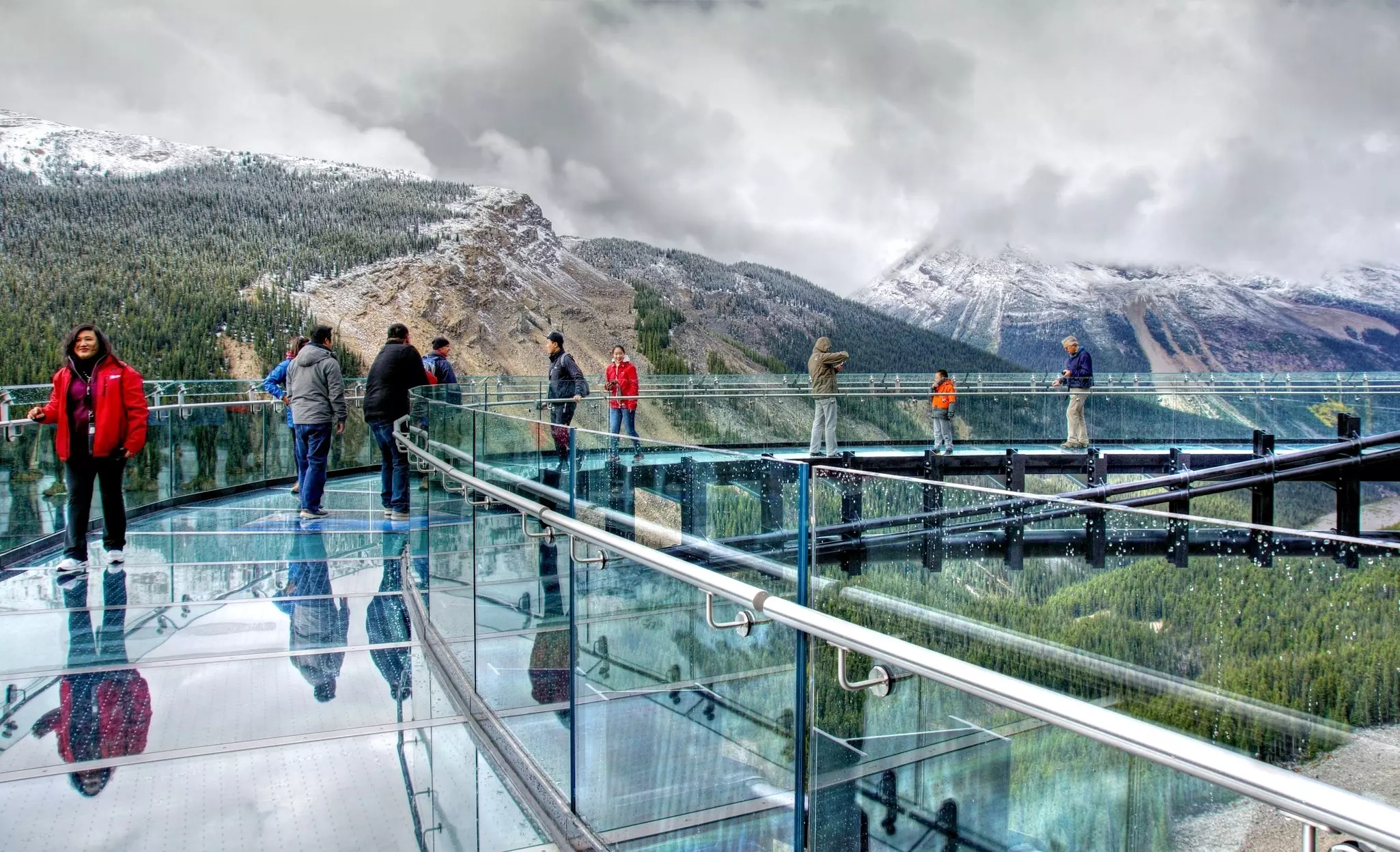
The Icefields Parkway (Promenade des Glaciers) is the crème de la crème of Canadian drives. This 230km (143-mile) trip links the nation’s two most emblematic national parks, Banff and Jasper, delivering staggering beauty throughout.
Starting near the robin-egg-blue waters of Lake Louise, home to the elegant Fairmont Chateau Lake Louise hotel, the route heads north through some of the most elemental scenery on the planet. Giant mountains, craning trees and powerful waterfalls are mere supporting acts to the gargantuan glaciers and abundant wildlife, which gets even more copious as you approach Jasper.
Along the route, a litany of potential stops offer access to superb viewpoints and short interpretive hikes. Headliners include cerulean Peyto Lake, Jasper’s “hanging” Skywalk and the Athabasca Glacier, a frozen tributary of the colossal Columbia Icefield.
Planning tip: Thundering Athabasca Falls is at its deafening best during the spring snow-melt.

Best road trip for archaeology
Start/finish: Deer Lake/St Anthony
Approximate distance: 434km (270 miles)
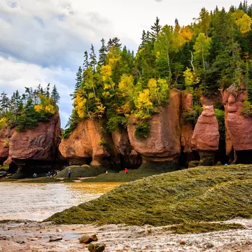
Ancient Indigenous burial grounds. Thousand-year-old Viking remains. Monumental icebergs, breaching whales and an almost supernatural national park whose trippy tablelands are a textbook guide to plate tectonics. Welcome to Newfoundland’s epic Rte 430, which links a patchwork of fog-cloaked coves, snow-capped mountains and stormy fjords.
Starting inauspiciously in the town of Deer Lake, the route plunges into Gros Morne National Park. Its waterside hub, Rocky Harbour, is a nexus for trails and boat trips and has a fun wildlife museum.
Further north lie two important archaeological sites. Port au Choix is a national historic site dedicated to the 5500-year-old burial grounds of three different Indigenous groups. L’Anse aux Meadows, meanwhile, is where Leif Erikson and his Viking buddies arrived approximately 1000 years ago – the first known European settlers in the Americas.
Planning tip: The trail ends at St Anthony, a small fishing village with a rough-hewn charm that makes a perfect stop for whale- and iceberg-watching.
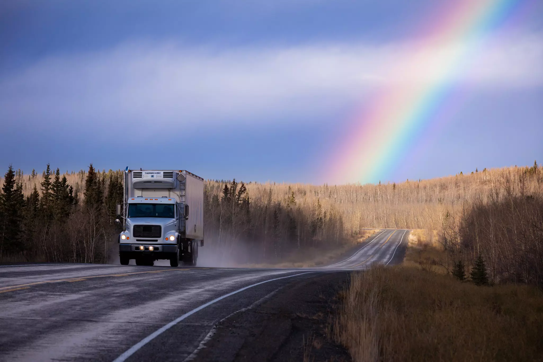
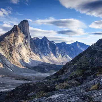
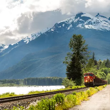
Best road trip for wilderness
Start/finish: Skagway/Dawson City
Approximate distance: 708km (440 miles)
Following the same basic route as the 19th-century’s greatest gold rush, this paved highway starts in Skagway, Alaska, crosses the Canadian border near the tiny town of Fraser, then passes through Carcross (home to the world’s smallest desert) en route to Whitehorse. In the capital, you can wise up on territorial history and the nuances of the Gold Rush at the town’s McBride Museum.
Head north of Whitehorse for sheer, unadulterated wilderness. Be sure to stop at the Braeburn Lodge, a rustic roadhouse known for its sweet, soccer-ball-sized cinnamon buns and appealingly brusque backcountry service. Blink and you’ll miss the self-sufficient communities of Carmacks, Pelly Crossing and Stewart Crossing. Plan for a longer stop at Five Finger Rapids, where a wooden staircase leads down to a viewing platform over the choppy Yukon River. The rafts of numerous Klondike prospectors have been upended on this rough stretch of water.
As you approach Dawson City, mine tailings from century-old dredging operations dot the roadside, alongside gravel piles and small ponds. The town is an understated beauty, filled with authentic gold rush history and the literary ghosts of novelist Jack London and poet Robert Service.

Best road trip for French-Canadian culture
Start/finish: Ste-Flavie/Ste-Flavie
Approximate distance: 822km (511 miles)
Towering cliffs, fresh-caught seafood and Québécois sea shanties are all on the itinerary as you circle La Gaspésie, the lofty peninsula contoured by Rte 132 on Québec’s eastern shores. You depart Ste-Flavie, make time to stop near Pointe-à-la-Croix at the Battle of the Restigouche National Historic Site, where a French-British naval clash in 1760 marked the death knell for French colonial ambitions in Canada.
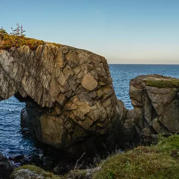
The Parc National de Miguasha has the world’s leading cache of ancient fish fossils, with a museum illustrating how prehistoric sea creatures evolved into tetrapods. The crown jewels of the Gaspé Peninsula are Rocher Percé, a huge offshore limestone rock formation with a seemingly gravity-defying arch; and blustery Forillon National Park, where mountains plunge directly into the choppy ocean and rugged cliffs stand sentinel over spouting whales.
Planning tip: After rounding the tip of the peninsula, head back along the St Lawrence waterway for a lengthy stop in the Parc National de la Gaspésie. A short drive inland from Ste-Anne-des-Monts, the park is a rough mountainous realm with fine hiking options.
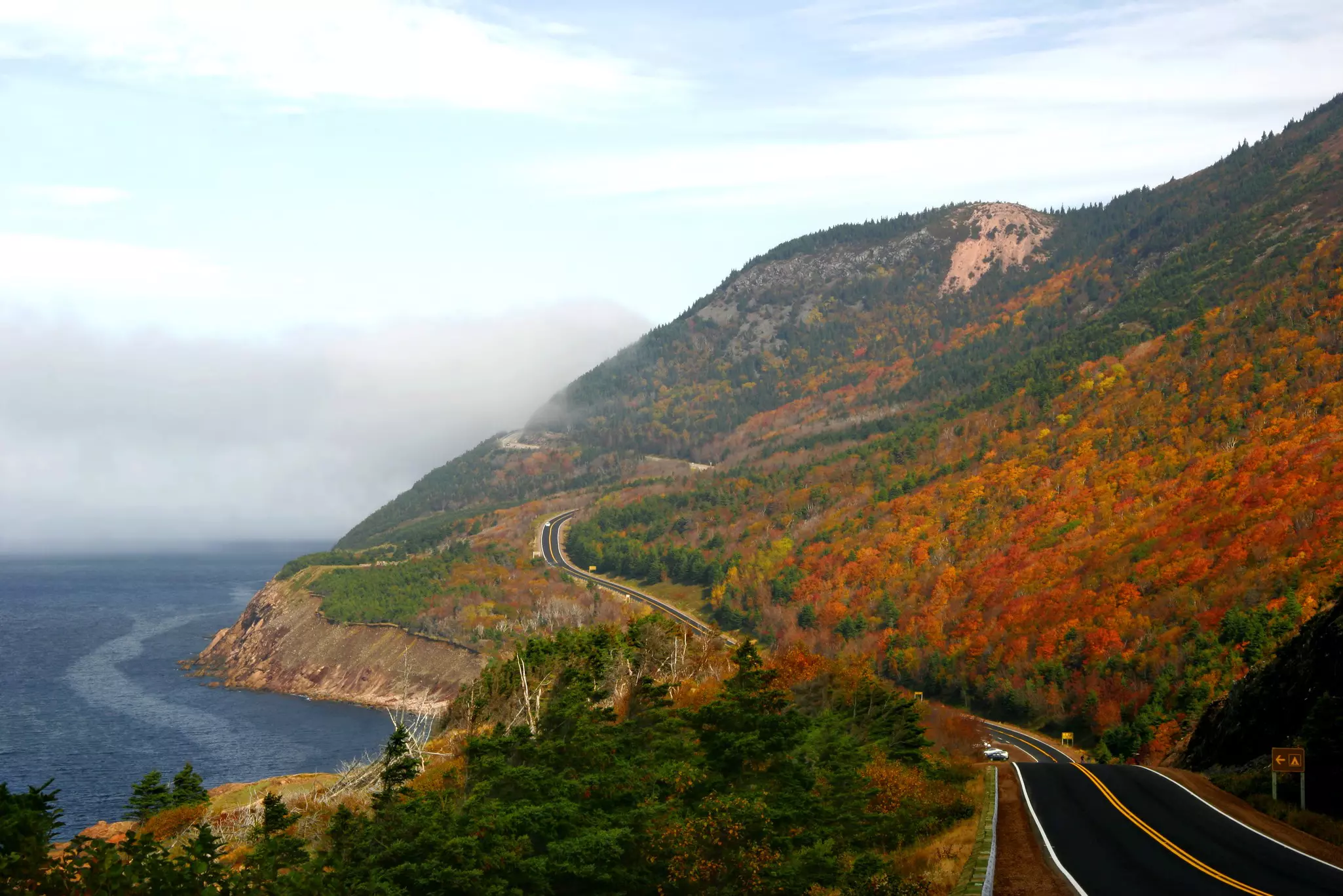
Best road trip for coastal scenery
Start/finish: St Ann’s Bay/St Ann’s Bay
Approximate distance: 286km (143 miles)
One of the main reasons travelers come to Nova Scotia is to drive the Cabot Trail, the looping, dipping roller-coaster of a road that snakes its way around the northern tip of Cape Breton Island.
Offering views of rolling seas and thick forests, and – if you're lucky – a moose, an eagle or even a whale, this maritime classic traverses the edge of Cape Breton Highlands National Park. The park is home to the province's grandest scenery, richest wildlife and best hiking trails.
Heading counterclockwise on the circular route, you’ll reach Ingonish Beach, a long, wide ribbon of sand sheltered in a bay cocooned by gentle hills and Pleasant Bay, Nova Scotia’s premier whale-watching hub. The Skyline Trail, the Cabot’s hiking highlight, meanders through evergreen forests and along windy clifftops to a spectacular ridge.
Other favorite stops include Cheticamp, Nova Scotia's most vibrant and thriving Acadian community; and Baddeck, home to a museum dedicated to former resident Alexander Graham Bell, pioneer of the very handy device known as the telephone.

Best road trip for lakes
Start/finish: Sault Ste Marie/Thunder Bay
Approximate distance: 700km (435 miles)
Even Canada’s most populated province can seem utterly remote as you motor along the northern shores of the world’s largest freshwater lake, following a quiet segment of the Trans-Canada Hwy through a necklace of provincial parks.
Pancake Bay Provincial Park hides one of Canada’s finest stretches of sugary sand; if you pull up off-season, you might have it all to yourself. Lake Superior Provincial Park protects a more precipitous coastline punctuated with the exposed rock of the Canadian Shield.
You can seek out Indigenous pictographs in the area, as well as fabulous opportunities for stargazing (the park was designated a Dark Sky Preserve in 2018). Similar solitude awaits at Rocky Neys Provincial Park, where Lawren Harris of the Group of Seven came to paint amid craggy beaches and roaming caribou.
Approaching Thunder Bay, you’ll pass the jagged Sleeping Giant Peninsula – a series of flat-topped ridges that resemble a large reclining man. The rugged, forested terrain here is characterized by cliffs, hiking trails and plentiful wildlife, including moose, wolf and lynx.
Take your Canada trip with Lonely Planet Journeys
Time to book that trip to Canada
Lonely Planet Journeys takes you there with fully customizable trips to top destinations – all crafted by our local experts.

Explore related stories