Jun 19, 20276 min read
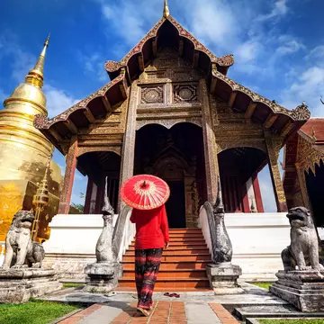
How to visit Chiang Mai on a budgetAug 5, 2022
13 MIN READ

Writer
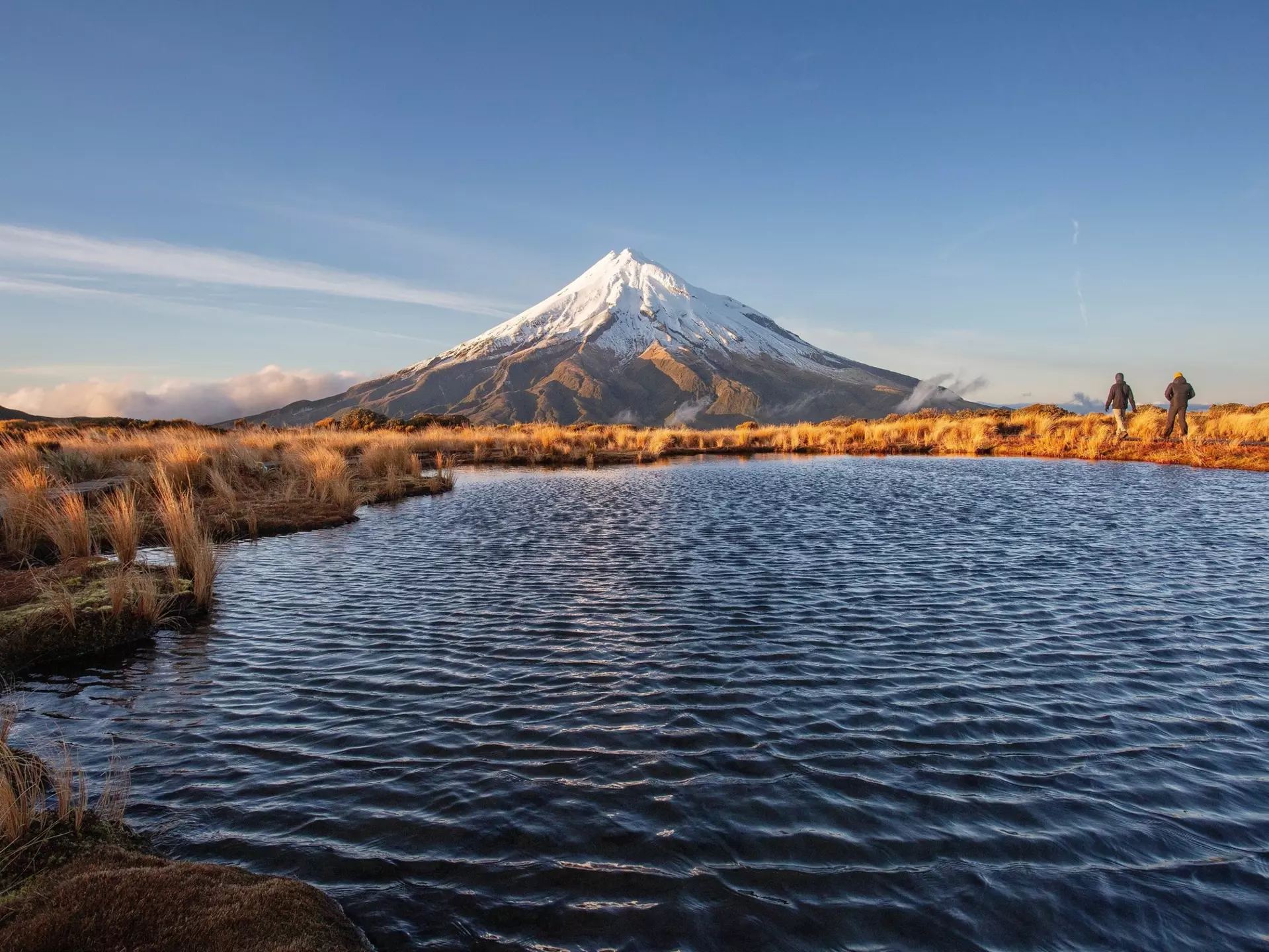
Mount Taranaki is New Zealand's most summited peak © jon alkain / Shutterstock
Writer
Lonely Planet may earn a commission from affiliate links on our site. All recommendations and reviews reflect our own independent opinions.
Mesmerizing waterfalls, active volcanoes, stunning coasts: Australia and New Zealand are an adventurer's playground.
Lonely Planet’s new book, Epic Hikes of Australia and New Zealand, celebrates the region as one of the world's best hiking destinations. The new guidebook features the vast variety of terrain, climate and landscape that can be found in both countries. Here are some highlights that will inspire you to go the distance down under.
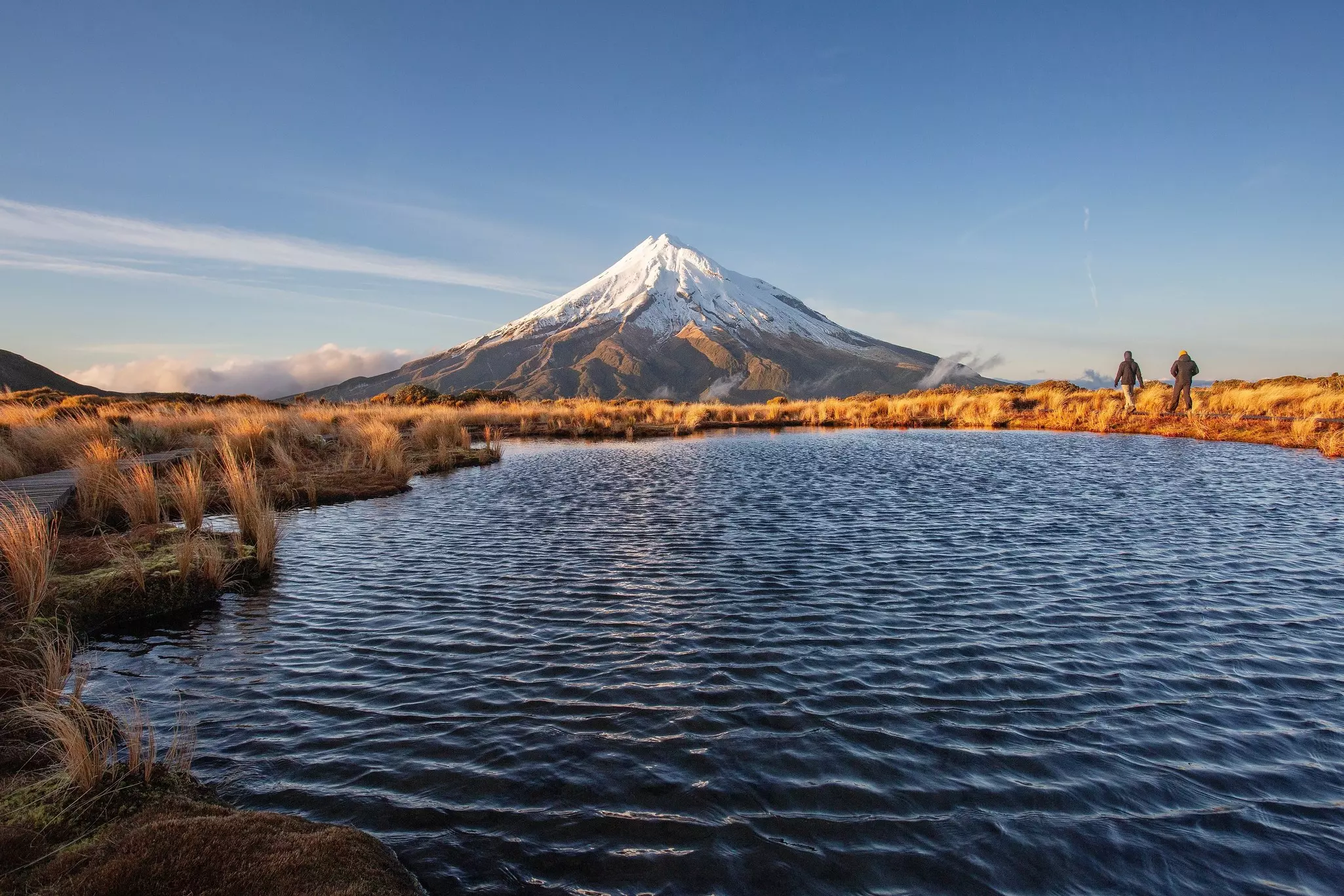
Start/Finish: Taranaki/Egmont National Park Visitor Centre
Distance: 12.6km (8 miles)
Duration: 8-10hr
The westernmost of the volcanoes that run like a studded belt across the North Island, Mt Taranaki is ribbed with trails, but it’s the summit (or very near to it – the summit area is sacred to Māori and hikers are asked not to stand right on its top) that is the 2518m (8261ft) mountain’s true siren, with Taranaki said to be New Zealand’s most climbed peak. This simple fact masks the challenge of this long day in the boots. From the park visitor center, it’s a climb of almost 1600m (5249ft) to the top of the volcano, which hasn’t erupted since 1854. The going is steep – there’s a section called ‘The Puffer’ for a reason – and there’ll be snow (and possibly ice) in the crater, but the view out across the Tasman Sea and inland to the Tongariro volcanoes is exceptional.
The 10 best experiences in New Zealand
Start/Finish: Rainbow Mountain Scenic Reserve car park
Distance: 7km (4 miles)
Duration: 3hr
Rotorua is no stranger to geothermal activity and, as the name attests, Maunga Kakaramea/Rainbow Mountain is one of the most colorful displays of its volcanic underbelly. The 743m-high (2437ft) mountain sits beside State Hwy 5, 26km (16 miles) south of Rotorua, and the straightforward trail ascends past the Crater Lakes, a pair of bright-blue lakes pooled at the foot of colorful cliffs. The walk climbs on past the cliffs to the summit, which looks over some of Rotorua’s other great moments in geothermal history: Mt Tarawera, which erupted violently in 1886; the deep incision of Waimangu Volcanic Valley; and the furiously steaming Wai-o-tapu Thermal Wonderland. Need to soak away some muscle soreness at walk’s end? The Waikite Valley Thermal Pools are just 9km (5.5 miles) down the road.
Top 11 national parks in New Zealand
Start/Finish: Tibrogargan trailhead, Barrs Rd
Distance: 3km (2 miles)
Duration: 2-3hr
One hour’s drive north of Brisbane, 11 craggy peaks rise out of the macadamia and pineapple crops to form one of Queensland’s most surreal landscapes: the Glass House Mountains. These peaks are remnants of volcanic plugs – solidified magma from inside the necks of volcanoes – and a number of the summits can be reached on foot. Perhaps the most imposing of the accessible peaks is Mt Tibrogargan, aka the Gorilla, which is also one of the most difficult but spectacular to climb. The 364m (1194ft) ball of rock can be lapped on a gentle 4km (2.5 mile) circuit trail, or there’s a more intrepid route to the top. This involves plenty of steep scrambling – a gorilla grip truly needed – but leads to a vast view out to the Sunshine Coast and Pacific Ocean. Mt Beerburrum and Mt Ngungun – fellow Glass House Mountains – provide easier summit moments.
Australia's 10 most iconic road trips
Start: Lyell Campground
Finish: Rough & Tumble Lodge Distance
Distance: 85km (53 miles) Duration
Duration: 5 days
Further up the West Coast from the Paparoa Track, near Westport, is the winding, weaving Old Ghost Road. The name would indicate that trail would be a long-established route but it only opened in 2015, after a process that can only be described as persistent. The creation story is told in a thin book called Spirit to the Stone, copies of which are scattered in the five spectacularly located huts along the route. Required reading for anyone interested in trails and trail building, it covers the story of landslides, proposed hydro dams potentially flooding its route, funding challenges and mountains and gorges that would have sent lesser men and women away with their hands in the air, surrendering to the steeps and deeps of the New Zealand wilderness. The graded trail flows over mountaintops and clings to sheer gorge walls. It was built very much with mountain bikers in mind, but it is a work of art to be much enjoyed by hikers too.
What it means to Leave No Trace: 8 principles to be more mindful outdoors
Start: Boyds Tower
Finish: Green Cape Lighthouse Distance
Distance: 30km (18 miles)
Duration: 2-3 days
A beauty of a coastal walk that will impress anyone who loves to exercise with a side of clifftops and sparkling beach. The trail is bookended with celebrations of the maritime history of this far South Coast gem of New South Wales. Sea kayakers, too, often enjoy this section of the coast but, with Bass Strait just around the corner, it can be a fearsome place. Paddlers often take refuge in the sheltered bays of Mowarry or Bittangabee. Like so much of the South Coast, the walk was impacted by the Black Summer bushfires of 2019/20. But, despite the torching, life is returning to blackened limbs, showing the resilience of the Australian bush. And, as part of the recovery, the Light to Light Walk is being redeveloped to offer both camping and hut experiences.
Why glamping might be the best way to see the Great Barrier Reef
Start: Palm Cove
Finish: Port Douglas
Distance: 94km (58 miles)
Duration: 5-6 days
Epic, purpose-built trails are appearing in all points of the Australian landscape, and the far northern reaches of Queensland are no exception. The Wangetti Trail takes a route exploring the coast and hinterland of the tropical landscape between Palm Cove and Port Douglas. Hikers and riders can explore the Wet Tropics World Heritage Area and Macalister Range National Park, among others, and should be on the lookout for everything from crocodiles to cassowaries. Being built in stages, the 33km (20-mile) section from Palm Cove to Wangetti was first to open, and the full trail with camping areas is due for completion in 2023.
The best bushwalking and trail running routes in Australia
Start/Finish: Tallanbana Trailhead
Distance: 4km (2.5 miles)
Duration: 2hr
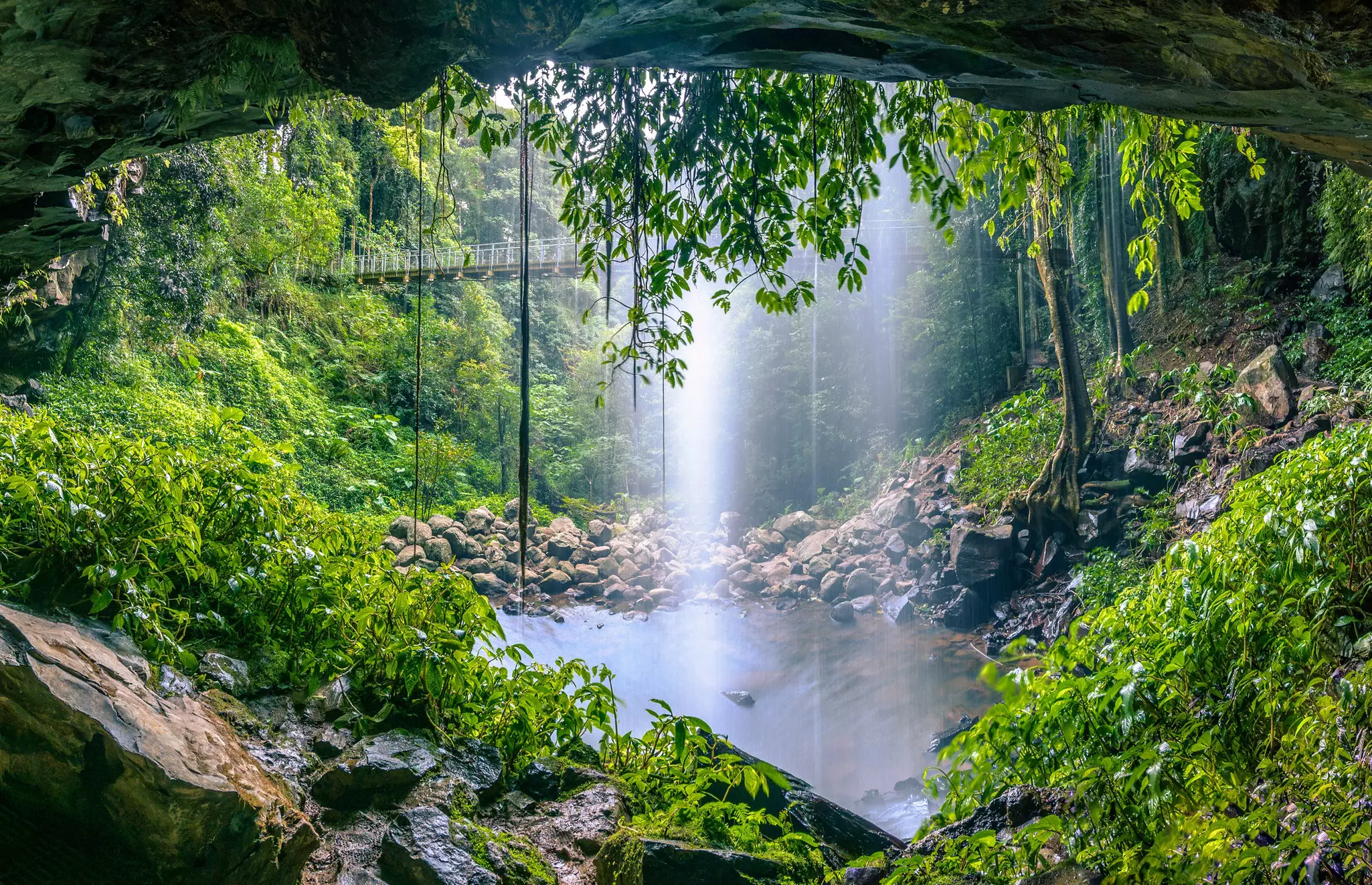
When time is short, this gorgeous hike in the Gold Coast hinterland offers a great taste of the Gondwana Rainforests. The best way to experience the walk is by following the trail in an anti-clockwise direction, starting from either the Tallanbana Trailhead or the Canyon Lookout. Signposted along the way, it’s a fairly easy route that passes behind two stunning waterfalls and among ancient brush box trees. Want more? This trail forms part of the Warrie Circuit, a 14km (8.7-mile) trek that takes five to six hours to complete. Sturdy footwear is recommended for both trails, which can get slippery behind the falls, even when it looks dry.
Australia's top 10 places for wild swimming
Start/Finish: Binna Burra upper day-use area
Distance: 17.4km (10.8 miles)
Duration: 7hr
The Coomera Circuit is a blockbuster day-hike offering some knockout scenery: rainforest-covered cliffs, verdant forest and some ravishing cascades, including the Coomera and Yarrabilgong waterfalls, which plunge into a 160m-deep (525ft) gorge. It’s one of the most breathtaking walks in the Binna Burra section of southeast Queensland’s Lamington National Park. Kicking off from the Binna Burra upper day-use area, it’s recommended to follow the trail in an anti-clockwise direction. You’ll leave the Border Track after 1.9km (1.2 miles) to ascend along the edge of the Coomera Gorge. As you follow the path of the Coomera River, keep your eyes peeled for the chance to see the bright blue-and-white Lamington spiny crayfish. There are a few river crossings before rejoining the Border Track and returning to the trailhead.
Melbourne or Sydney: which city is the best to start your Australian adventure?
Start: Brindle Creek picnic area
Finish: Antarctic Beech picnic area
Distance: 6km (3.7 miles)
Duration: 3-4hr
Don’t forget to pack your swimwear for this beautiful walk in the high country of northern NSW – there are plenty of places to take a dip along the way, including Evan Falls. The Brindle Creek Walking Track follows a creek line through misty rainforest and is a highlights reel of the most spectacular scenery of the Border Ranges National Park: you’ll pass ancient, looming Antarctic beech trees and massive hoop pines, and have the chance to spot the lovely helmholtzia lillies that thrive in the damp, moist air. Pack a picnic to enjoy at the Antarctic Beech Picnic Area, where bandicoots and pademelons might be your lunch guests. Leave plenty of time to return, retracing your steps to the Brindle Creek Picnic Area.
Australia’s Great Ocean Road is one of the world's best drives: here are the best detours
Start: East Warburton
Finish: Don Valley
Distance: 35km (22 miles)
Duration: 2 days
If you don’t fancy climbing Mt Donna Buang, the highest point in Victoria’s Yarra Ranges National Park and all the more so thanks to a lookout tower at its top, then this trail is almost as epic an alternative. It runs for around 35km (22 miles) through much of this forested national park from East Warburton to Don Valley, a short drive northeast of Melbourne. The trail follows the route of the aqueduct that was built in 1914 to funnel fresh water to the city, an amazing feat of engineering. Being an aqueduct, it’s a largely level route, with a few steep pitches. If you wish you could also run or ride it. Either way, it gives a flavor of the temperate rainforest of the Ranges, with ferns unfurling far above your head and above them the dense canopy of mountain ash trees. It’s a walk among giants.
23 unmissable things to do in Australia
Start: Wallaman Falls camping area
Finish: Henrietta gate pick-up point
Distance: 56.8km (35.3 miles)
Duration: 3 days
Part of the Wet Tropics Great Walk, a 110km (68.4-mile) epic trail linking two of the Townsville region’s most spectacular waterfalls (Wallaman Falls and Blencoe Falls), the Djagany (Goanna) Walk offers a great taste of the full tramp, which takes around 10 days. Admire Wallaman Falls – Australia’s highest single-drop waterfall – before setting out on an old forestry track through a number of forest types that form part of the Unesco-listed Wet Tropics World Heritage Area. Look out for brilliant blue Ulysses butterflies fluttering through the rainforest, with tranquil creek crossings providing a welcome respite from the midday heat. The first two days on the trail end at remote walkers’ camps, where you’ll doze off to the sounds of the Aussie bush.
Australia's 7 best nudist beaches
Start: Robinsons Knob Trail car park
Finish: Darkwood Rd
Distance: 33km (20.5 miles)
Duration: 2-3 days
Descending over 1000m (3281ft) from the edge of New England Tableland, east of Armidale, to the headwaters of the Bellinger River, this multi-day hike invites experienced bushwalkers on a journey through one of NSW’s most diverse wilderness areas. The first 1.7km (1 mile) of the trail takes you through lush, cool temperate forest to Wrights Lookout, where you can enjoy spectacular panoramic views over New England National Park, part of the Unesco-listed Gondwana Rainforests. From here the trail continues along Snowy Range, then down towards the valley floor – admire the changing environment as you descend. Once you reach the valley floor, you’ll wander along an old farm trail over grassy river flats, passing historic farmhouses and stockyards on the way.
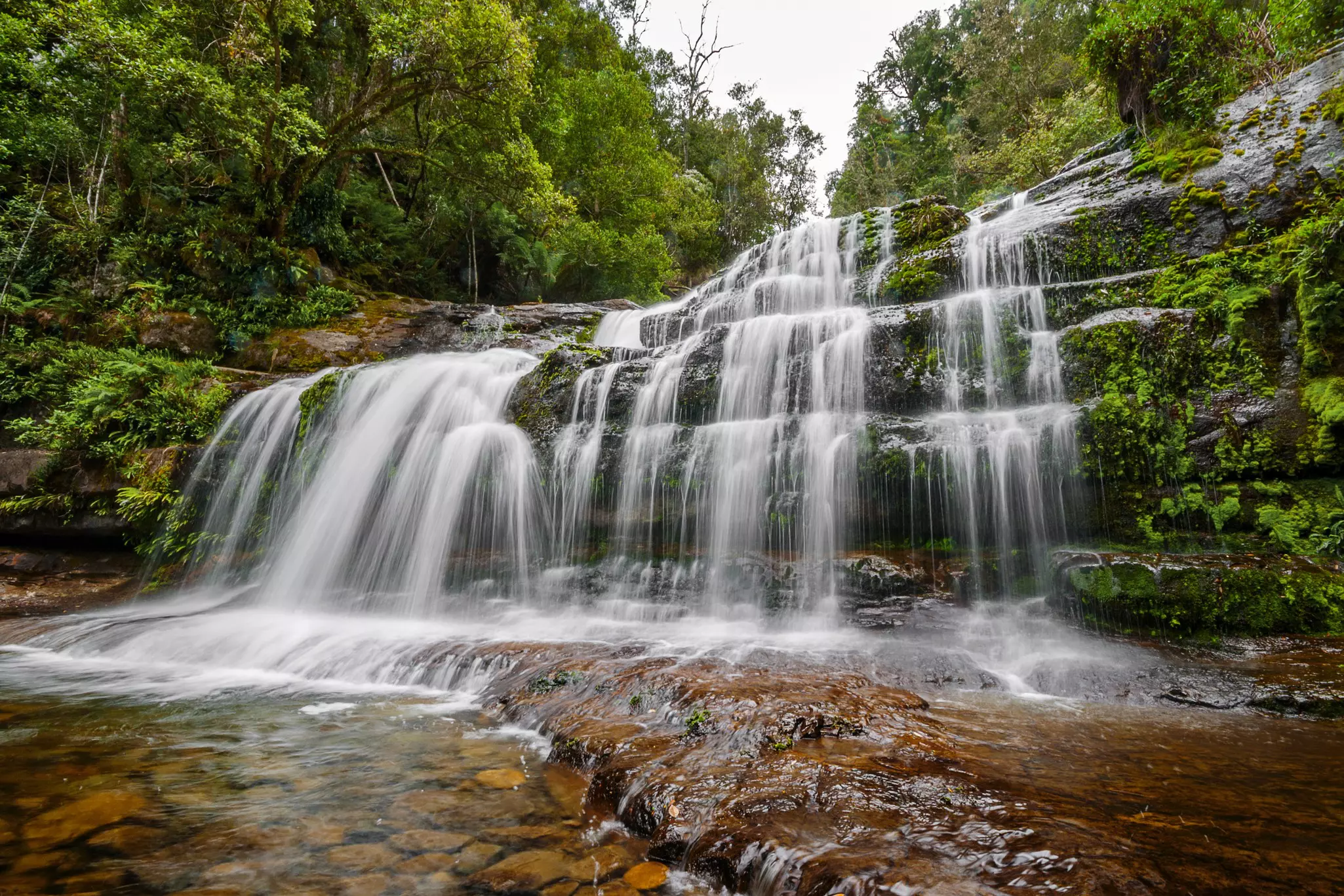
Start/Finish: Meander Falls Rd car park
Distance: 10km (6.2 miles)
Duration: 6hr
Another memorable Tassie waterfall hike can be enjoyed an hour’s drive southwest of Launceston, in the heart of the dramatic Great Western Tiers Conservation Area. Climbing uphill through beautiful wet forest, the out-and-back trail leads to the base of one of the state’s most spectacular waterfalls, which plunges 130m (427ft) over two main tiers. With some steep, rocky and muddy sections to navigate, the trail can be a little challenging for some. Snow and ice can be experienced in winter months, although this can be a plus if you’re treated to the spectacle of large icicles forming on the falls. Sturdy shoes and warm layers are a must year-round.
Sustainable Australia: top tips to minimize your carbon footprint and travel slow
Start/Finish: Canyon Lookout or Tallanbana Trailhead
Distance: 14km (8.9 miles)
Duration: 5-6hr
Warrie is a local Aboriginal language word for ‘rushing water’, which offers the first clue that there’s plenty of waterfall action to be enjoyed on this pretty rainforest trail on the lush Springbrook plateau, an easy day trip from the Gold Coast. The moderately challenging, well-marked circuit follows the base of The Canyon cliffs to Goomoolahra Falls (look out for the giant spear lilies that grow here) before descending into the mossy green depths of the forest. Crossing several creeks and gullies along the way, the track reaches the ‘Meeting of the Waters’, where all watercourses draining The Canyon meet, before climbing up the western side of the gorge. Hiking boots are a must, particularly after rain when the trail can get quite muddy.
Australia's 8 best surfing spots from the Pacific to the Indian Ocean
Start/Finish: Finch Hatton Gorge car park
Distance: 4.2km (2.6 miles)
Duration: 1.5-2hr
Named for the distinctive orange flowers that bloom in the surrounding rainforest trees, the Wheel of Fire Track is an ultra- scenic hike in the magnificent Finch Hatton Gorge section of Eungella National Park, west of Mackay, with several spectacular waterfall swimming spots. Around a kilometer along the well-maintained rainforest trail, which is shaded by the canopy for most of the way, the path forks. Here you can cheat and take a short stroll to the beautiful Araluen Cascades, but it’s worth pushing on uphill between huge granite boulders to enjoy the superb views of Finch Hatton Creek cascading down through the gorge as you go. At the top there’s another waterfall pool, which tends to be several degrees cooler than the swimming area at the Araluen Cascades – perfect for an invigorating dip on a hot summer’s day before heading back down the way you came.
Australia's newest national park will protect endangered species
Take your Australia trip with Lonely Planet Journeys
Time to book that trip to Australia
Lonely Planet Journeys takes you there with fully customizable trips to top destinations – all crafted by our local experts.

Explore related stories