Jun 9, 20267 min read
8 of the best beaches in TaiwanOct 21, 2023
7 MIN READ

Writer
Highlights
Writer Tom O'Malley picks 10 Taiwan hikes from alpine summits to coastal trails.
Tackle Holy Ridge in Shei-pa, or summit Jade Mountain, northeast Asia's highest point.
Try Taroko's Zhuilu Old Trail or the Mianyue Line's logging tunnels in Alishan.
For city views, head to Elephant Mountain; for glacial solitude, trek Jiaming Lake.
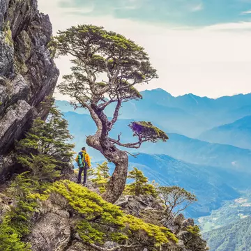
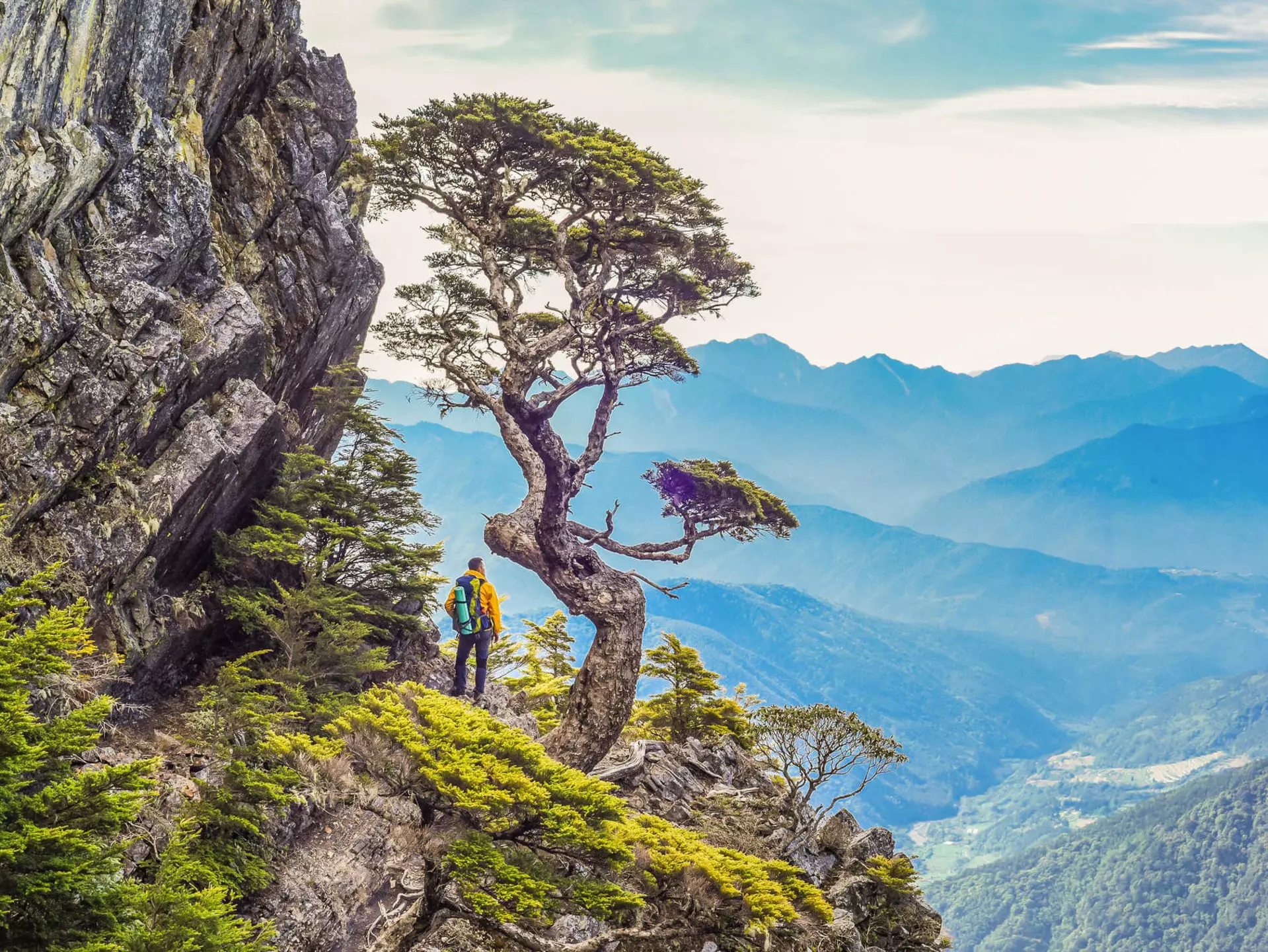
A number of route variations incorporate the Holy Ridge at Shei-pa National Park © weniliou / Shutterstock
Writer
Highlights
Writer Tom O'Malley picks 10 Taiwan hikes from alpine summits to coastal trails.
Tackle Holy Ridge in Shei-pa, or summit Jade Mountain, northeast Asia's highest point.
Try Taroko's Zhuilu Old Trail or the Mianyue Line's logging tunnels in Alishan.
For city views, head to Elephant Mountain; for glacial solitude, trek Jiaming Lake.
Lonely Planet may earn a commission from affiliate links on our site. All recommendations and reviews reflect our own independent opinions.
In subtropical Taiwan, hiking is practically a national sport. For a place less than half the size of Scotland, this little island packs in a big topography – more than 260 peaks over 3, 000m (9, 843ft) high.
Of those, the baiyue ("100 peaks") represent the ultimate hiking bucket list: 100 high-altitude routes hand-picked by outdoors enthusiasts for the beauty and diversity of their terrain.
At the gentler end of the scale, Taiwan has scenic coastal paths, historic walking trails, adventurous day hikes and waterfall romps to suit all abilities.
The year 2020 was declared Taiwan’s Year of Mountain Tourism, and since the pandemic took its toll on outbound travel, even more Taiwanese have taken to the trails. That’s some turnaround for a country where, before 1987 and the end of martial law, much of the mountains were off-limits. Here are ten memorable hikes to get you started.
Best for multi-day mountaineers 15km (9. 3 miles), 3 to 6 days depending on route, challenging
Connecting Xueshan (Snow Mountain), Taiwan’s second highest peak, with Dabajianshan, this world-class route follows a precipitous ridgeline that never dips below an altitude of 3, 000m (9, 843ft).
You’ll need to be comfortable using fixed ropes to descend vertical cliff faces, have a head for serious heights and be able to do it all with several days’ worth of gear on your back. But the rewards are spectacular.
A number of route variations incorporate the Holy Ridge: the popular "O" route is a circular, five- to six-day adventure that summits six peaks above 3, 300m (10, 827ft). Permits are required, which can be applied for via the Shei-pa National Park website.
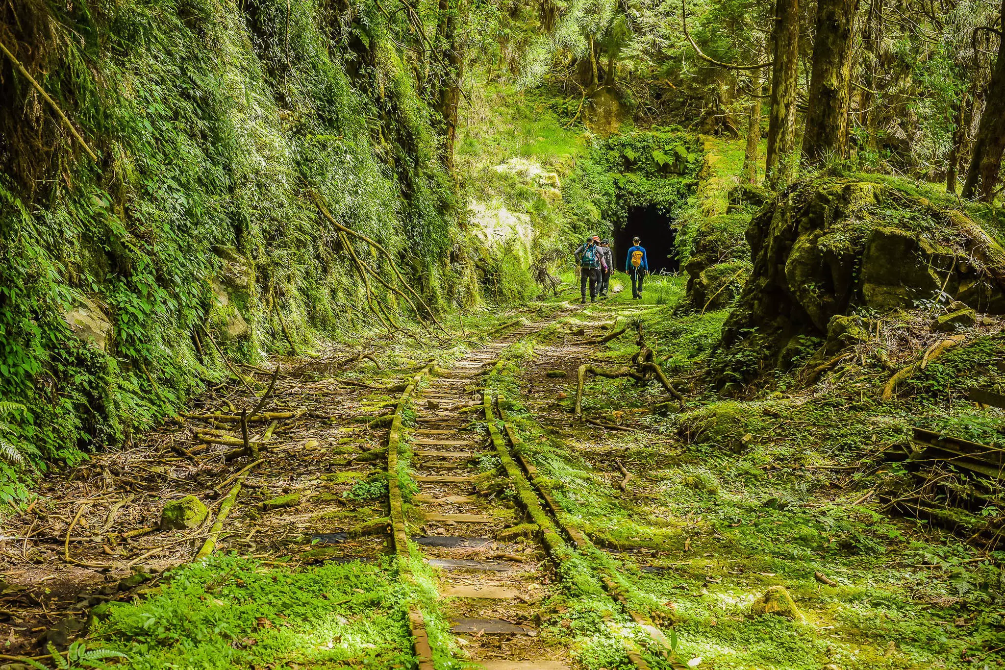
Best for whimsical adventure 9km (5. 6 miles), 1. 5 hours, easy to moderate
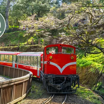
This unusual route follows part of a defunct old logging railway built by the Japanese a century or so ago to carry timber out of the mountains.
Following the tracks for much of the way, hikers have to step carefully from plank to plank over moss-shrouded railway bridges and pick their way through tunnels, some pitch dark and others partially collapsed by earthquakes, all the while marveling at the serene old-growth forest all around.
Permits are required for this particular trail in Alishan Forest Recreation Area and should be applied for well in advance.
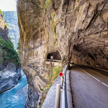
Best for spectacular views 6km (3. 7 miles), 3 to 6 hours, moderate
Taiwan’s preeminent scenic wonder, Taroko National Park really puts the "gorge" into gorgeous. Carved out by the Liwu River, Taroko’s spectacular metamorphic canyon is cut through with accessible, paved hiking trails and cycle routes. But the most impressive by far is the Zhuilu Old Trail.
Originally engineered as a hunting path by the indigenous Truku people, this heart-thumping route follows a ledge barely 70cm (2. 4 inches) wide in places, with rocky overhangs and plunging verticals 750m (2, 461ft) down to the turquoise waters below.
Only around 100 hikers are permitted on the trail in a single day, so apply well in advance for the necessary permits.
Best for waterfalls 2. 5km (1. 6 miles), 2. 5 hours, easy
Half the fun of this hike is riding the charming old Pingxi coal railway and alighting at Taiwan’s only train station unreachable by car.
From Sandiaoling (population: less than 20), a well-marked trail rises uphill, passing three magical waterfalls, two of which invite you to scramble over rocks and perch behind the plunging cascades.
For the waterfall addict, continue your hike (another 1. 5 hours) along back country roads all the way to Taiwan’s "Little Niagara" at Shifen, the widest falls in the country, where you’ll also find cold beers and hawkers grilling sausages.
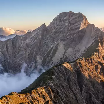
Best for bragging rights 22km (13. 7 miles), 2 days, challenging
At 3, 952m (12, 966ft) to the summit, the main trail of Taiwan’s highest peak is a two-day round trip, passing through hemlock and spruce forests into rolling meadows of alpine flora.
For the most part the going is straightforward with wide paths, clear signposting and only a few steep sections on loose scree near the summit. When you make it there, congratulate yourself for topping out at the highest point in northeast Asia, a couple of hundred meters above Japan’s Mt Fuji.
Hikers must overnight at Paiyun Lodge on route, so book your sleeping berth, optional meals and required park permits well in advance.
Best for hair-raising thrills 5. 5km (3. 4 miles), 4 to 6 hours, extreme
Gloves are a must when tackling this hardcore day hike within easy access of Taipei. Ropes and guide poles exact a toll on the hands as you scramble up sheer boulders and knife-edge crags to scenic lookouts, with distant views of Taipei 101 in clear weather.
Count on a strenuous full-body workout if you make it up all five peaks, the highest clocking in at 639m (2, 096ft) above sea level.
Be warned that in places, the ridge path is little more than a hand’s width across – not for the faint of heart.
Best day hike with sea views 9. 5km (5. 9 miles), 3 to 4 hours, family-friendly
Before roads and rail, this old Qing dynasty trail was part of the only land route cutting through the wild northeast coast of Taiwan.
These days the restored trail makes for a terrific day hike, easily accessible by rail from Taipei (to Fulong), with paths and steps that rise gently through wooded countryside up to a high grassy bluff grazed by water buffalo with inspiring sea views out towards Turtle Island.
For a more substantial hike, you can press on over windswept coastal grasses along the Taoyuan Valley trail, which boosts the total length to 16km (9. 9 miles). Otherwise, descend to Qingyun Temple and Daxi train station for transport back to the city.
Best for skyline selfies 2. 5km (1. 5 miles), 1. 5 hours, easy
Just a stone’s throw from central Taipei, this hillside trail has its own dedicated MRT station, which naturally means plenty of crowds on weekends and clear days.
It takes about 45 minutes on a moderately steep, stepped path to reach the "Six Giant Rocks," a cluster of climbable boulders where most walkers stop and about-face for sensational views of the capital’s Xinyi district, dominated by that ever-compelling steel obelisk, Taipei 101.
The light show at sunset, as the sky fades to purple and the city begins to twinkle, is what your smartphone’s "night mode" was made for.
Best for off-the-beaten-track isolation 26km (16. 1 miles), 2 to 3 days, moderate to challenging
The trek to this small glacial lake, the second highest in Taiwan, follows a non-technical mountain-ridge trail that passes through several wildlife-rich forest zones before emerging above the tree line.
Keep an eye out for flying squirrels en route; you might startle the occasional sambar deer once you reach the sweeping alpine grasslands leading to the lake.
Along the way you can veer off to summit Sanchashan, an easy climb that will nevertheless bag you one of the ten highest mountains in Taiwan. Note that permits and cabin bookings are required.
Best short hike with Instagram-worthy views 3. 6km (2. 2 miles), 2 hours, moderate
This express hike, paved all the way, is extremely popular due to its proximity to the tourist magnet of Jiufen and its famous snack street.
It’s up to you to decide whether the peak, at 599m (1, 965ft), actually resembles a teapot, but the fun part is clambering through the cave inside it, using ropes and emerging on the other side to spectacular coastal views. Note that this route can be bypassed for those who don’t like tight spaces.
Teapot Mountain can be extended in several ways, including tacking on the trail to Banpingshan and the much-vaunted Stegosaurus Ridge.
March to May and October to December will give you the best weather conditions for hiking.
Subtropical Taiwan has extremely changeable conditions, so it’s smart to pack sunscreen, mosquito repellent, wet-weather gear and extra water.
Check well in advance about permit requirements before planning a hike. You might consider going with a hiking tour agency to circumvent the permit-application process.
Bring earplugs if overnighting in a trail cabin.
Explore related stories