The story of the Smoky Mountains began in primordial times when clashing supersized continents created a chain of mountains that are today among the oldest on the planet. Some of the rock here formed at the bottom of an ancient sea over a billion years ago, which were later uplifted when the African tectonic plate slammed into the side of North America.
The human history here is ancient, too – Indigenous peoples have lived in the region of the Smoky Mountains since prehistoric times, an archeologists have found 10,000 year old hunting projectiles and ceramics from 700BCE. When European settlers arrived in the 17th century, they encountered the Cherokee, who lived in settlements along the river valleys. The Smokies lay at the center of their vast territory until they were forced out of the region on the Trail of Tears. In the 1900s lumber companies arrived, nearly wiping out the forests. Luckily, in the 1920s a few visionary locals fought for the park’s creation, which finally became a reality in 1934.
Today, Great Smoky Mountains National Park is the most visited in the United States. That's in part thanks to its easy access from numerous major metros, including North Carolina's research triangle, Knoxville, Tennessee; Atlanta, Georgia; and Washington, DC. It's also thanks to the early decision to make the park very drivable, with a mixture of roads and hiking trails that appeal to a variety of nature lovers from casual history buffs and wildlife watchers to seasoned backpackers and thru-hikers. The cherry on top is that this national park is free to access, with no entrance fees or America the Beautiful pass required.
If that piques your interest, we have information on how and when to visit, what to see, where to camp, and which trails should be on your Smoky Mountains bucket list. Whether it's your first time in the Smokies or you're a long-term regular, just read on.

Hiking in Smoky Mountains National Park
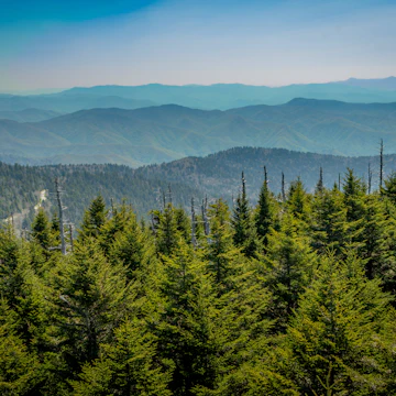
The Smokies are part of the vast Appalachian chain, among the oldest mountains on the planet. Formed more than 200 million years ago, these ancient peaks were once much higher – perhaps as high as the Himalayas – but have been worn down by the ages. You can contemplate that remote past while huffing your way up to the top of a 6000ft peak overlooking the seemingly endless expanse of undulating ridges that stretch off into the distance. There are mesmerizing viewpoints all across the park, as well as one mountaintop lodge that can only be reached by foot.
Home to more than 800 miles of walking trails, the national park has no shortage of great hikes, from short waterfall jaunts to multiday treks across the breadth of the mountains. Here are a few highlights:
Clingmans Dome
No matter when you visit, the highest peak in the national park offers dazzling views. From the circular, flying-saucer-like viewing platform, you'll have a sweeping 360-degree panorama of the undulating waves of forested peaks that stretch off into the distance. While it's an easy but steep uphill walk along the paved half-mile path to the observation tower, there are many outstanding trails that cross through here – including the Appalachian Trail and the Alum Cave Bluffs trail. And if you come in winter, when the access road is closed, you'll have those grand views all to yourself.
The Appalachian Trail
America's most fabled walk in the woods stretches for nearly 2200 miles across 14 states. Some 71 miles of the challenging trail runs along the spine of the Smoky Mountains, taking you to soaring overlooks, through misty coniferous forests and past old-fashioned fire towers offering staggering views over the park's verdant expanse. Even if you don't have a week to spare (much less six months to hike the whole Appalachian Trail), you can still enjoy some marvelous day or overnight hikes along this legendary trail.
Mt LeConte
One of the most challenging and rewarding day hikes in the park is the ascent up Mt LeConte, the third-highest peak in the Smoky Mountains. Several trails wind their way up, passing rushing rivers, waterfalls, log bridges and precipitous views before reaching the summit at 6593ft. At the top, you can pay a visit to the rustic lodge that's been in operation since before the creation of the national park in 1934. Book a cabin (well in advance) to make the most of this extraordinary Smoky Mountain experience.

Alum Cave Bluffs
One of the 10 most popular trails in the Smoky Mountains, Alum Cave Bluffsoften draws a crowd. It's a fantastic walk crossing log bridges, spying old-growth forest and enjoying fine views, though you should try to be on the trail before 9am to enjoy the scenery without the maddening crowds. Highlights include Arch Rock, where handcrafted stone steps ascend steeply through the portal of an impressive stone arch that looks like something Frodo was compelled to climb. Beyond this interesting formation, the trail crosses the Styx Branch and begins a steep ascent.
The forest gives way to open sky at the next point of interest, a large heath bald where mountain laurel and blueberry bushes grow in a dense mass. After some huffing and puffing, you’ll be repaid for your efforts at a scenic vista called Inspiration Point. From here, it’s a short climb to Alum Cave Bluffs. As it turns out, the name is a misnomer. Waiting for you is not a cave, but rather a rock overhang. Moreover, the rocks contain not alum, but sulfur and rare minerals, some not known to occur elsewhere. If you’re game for more delightful punishment, you can continue on from Alum Cave Bluffs to the summit of Mt LeConte, 2.7 miles up the trail.
Ramsey Cascades
One of our favorite hikes in the park, the trail to Ramsey Cascades travels through old-growth forest dotted with massive tulip trees to one spectacular waterfall. You'll need to work hard to make it here – it's tough going, with an elevation gain of 2280ft. The hike's start is deceptively easy, along a wide, packed trail beside the rushing Middle Prong of the Pigeon River. At mile 1.5 things get interesting (hard, rather) as the path narrows and winds its way uphill over spidery roots and past scenic overlooks of the rushing river below.
Around mile 2.6 you'll pass massive old-growth trees that have loomed over the forest canopy for centuries. The final half-mile steepens even more before you finally reach the refreshing falls, which plunge 100ft over chiseled ledges of gray stone. Congratulations, you've made it to the highest waterfall in the park. Don't ruin the moment by trying to climb up the waterfall, as a few people have died falling from the slippery rocks up top. Instead, keep an eye out for well-camouflaged salamanders on the periphery of the pool at the base of the cascades.

Camping in the Smokies
Great Smoky Mountains National Park provides varied camping options. LeConte Lodge is the only place where you can get a room, however, and you have to hike to the top of a mountain to enjoy the privilege. Gatlinburg has the most sleeping options of any gateway town, though prices are high. Nearby Pigeon Forge, 10 miles north of Sugarlands Visitor Center, and Sevierville, 17 miles north, have cheaper options.
The National Park Service maintains developed campgrounds at nine locations in the park (a 10th remains closed indefinitely). Each campground has restrooms with cold running water and flush toilets, but there are no showers or electrical or water hookups in the park (though some campgrounds do have electricity for emergency situations). Each individual campsite has a fire grate and picnic table. Many sites can be reserved in advance, and several campgrounds (Cataloochee, Abrams Creek, Big Creek and Balsam Mountain) require advance reservations.
With nine developed campgrounds offering more than 900 campsites, you'd think finding a place to pitch would be easy. Not so in the busy summer season, so plan ahead. You can make reservations for most sites; others are first-come, first-served. Cades Cove and Smokemont campgrounds are open year-round; others are open March to October.
Backcountry camping is an excellent option, which is only chargeable up to five nights ($4 per night; after that, it's free). A permit is required. You can make reservations online, and get permits at the ranger stations or visitor centers. Be sure to know the campground regulations.

Driving the Smoky Mountains
As Philip D'Anieri explains in The Appalachian Trail: A Biography, building scenic byways into national parks was a controversial idea at the time parks like Shenandoah and Great Smoky Mountains were first established. Did they give the American public well-deserved access to natural spaces where they could find recreation and spiritual contemplation, or did they represent the intrusion of the urban world into pristine natural spaces best experienced on foot?
That's a debate that still grips the outdoor community today, but in the end, roads are part of what make the Great Smoky Mountains experience what it is today. A slow ride along stretches of Little River Road, Cades Cove Loop Road, through the Cataloochee Valley, or Upper Tremont Road is the perfect way to take it easy – and with 384 miles of road in the Smokies, you can keep coming back for more. Here are some highlights:
Newfound Gap Road
The only paved route that bisects the park, the Newfound Gap Road offers fabulous scenery of the mountain forests as it curves its way for 33 miles between Cherokee, NC, and Gatlinburg, TN. While you could make the north–south traverse in an hour or two, it's well worth taking it slow, stopping at scenic overlooks, having a picnic lunch beside a rushing mountain stream and going for a hike or two along one of the many memorable trails that intersect this iconic motorway.
Roaring Fork Motor Nature Trail
Although it's just 5.5 miles long, this scenic road holds a treasure chest of natural wonders. Named after the fast-flowing mountain stream that courses beside it, the Roaring Fork takes you to lookouts with panoramic views over the mountains, past pockets of old-growth forest and right beside shimmering waterfalls tumbling over moss-covered stones. You'll also see vestiges of human settlement in the area, including an old farmstead that sheds light on the area's early inhabitants. Several excellent hiking trails start from this road, including to the lovely Grotto Falls.
Foothills Parkway
After years of construction and tens of millions of dollars in investment, a new 16-mile stretch of the Foothills Parkway was slated to open in late 2018. Visitors can now enjoy a 33-mile stretch of magnificent views on the newly extended parkway.

More things to do
The sun-dappled forests of the Great Smoky Mountains are a four-season wonderland. Rich blooms of springtime wildflowers come in all colors and sizes, while flame azaleas light up the high-elevation meadows in summer. Autumn brings its own fiery rewards with quilted hues of orange, burgundy and saffron blanketing the mountain slopes. In winter, snow-covered fields and ice-fringed cascades transform the Smokies into a serene, cold-weather retreat. This mesmerizing backdrop is also a World Heritage Site, harboring more biodiversity than any other national park in America. Here are a few activities that will get you in on the fun:
See the fireflies
Each year in late spring or early summer, parts of the national park light up with synchronous fireflies, a mesmerizing display where thousands of insects flash their lanterns (aka abdominal light organs) in perfect unison. The event draws huge crowds of people to the Elkmont Campground, one of the best places in the Smokies to see it. Dates of the event change every year, but it can happen anytime between late May and late June.
Viewing dates are typically announced in April. All those who want to see the event must obtain a parking pass through a lottery system, and then take a shuttle to the site. The service runs from the Sugarlands Visitor Center for eight days of predicted peak activity during the fireflies’ two-week mating period.

Wildlife watching in Cataloochee
Tucked into the eastern reaches of the national park, Cataloochee is one of the top wildlife-watching spots in the Smokies. You can watch massive elk grazing, see wild turkeys strutting about and perhaps even spy a bear or two. Hiking paths crisscross the valley, including the Boogerman Trail, which leads through old-growth forest. Cataloochee was also home to one of the largest settlements in the Smokies, and you can delve into the past while wandering through log cabins, a one-room schoolhouse and a photogenic church, all dating back to the early 1900s.
Rafting the Pigeon River
Many winding creaks and crystal-clear streams rushing through the Smokies find their way into the Big Pigeon River. When they converge, they create a fantastic setting for white-water adventures on churning rapids amid a gorgeous forest backdrop. Families with small kids can enjoy a peaceful paddle on the Little Pigeon, while those seeking a bit more adventure should opt for the Upper Pigeon with its class III and IV rapids. It all makes for a fun day's outing with some of the best rafting in the southeast.

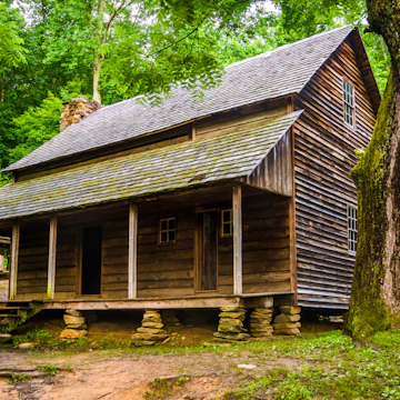
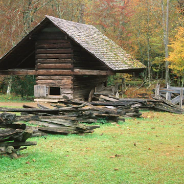
History at Cades Cove
Surrounded by mountains, the lush valley of Cades Cove is one of the most popular destinations in the national park. The draw: great opportunities for wildlife-watching, access to some fantastic hiking trails, and remnants of buildings from the 19th and early 20th centuries. In fact, on an easy tour of the area, you can visit old churches, barns, log houses and a working gristmill, most of which date back to the first European settlement in the 1820s.

When to visit
The park is open year-round, but summer and fall are the most popular seasons, lush with wildflowers and colorful fall foliage. Some facilities are closed late fall through early spring, and roads may be closed in winter due to inclement weather.
In April, spring makes its appearance with wildflowers, bigger crowds (during spring break) and the reopening of most campgrounds and roads. Nights can still dip below freezing (take note campers), but days can be delightfully sunny and warm. May is one of the best months to see spring wildflowers and flowering trees such as dogwoods and redwoods in the forests. Warm days mix with rainfall (a year-round possibility), and lodging prices are still lower than peak summer rates.
June and July are some of the most popular months in the park with school out for the summer, the synchronous fireflies putting on their show, and the Independence Day Midnight Parade in Gatlinburg. The fall leaf-peeping peak kicks in around October, when campgrounds fill up and roads slow to a crawl on weekends. By November, the crowds thin as the blazing autumn colors now litter the floor (rather than the treetops). Some roads and campgrounds close for the season. You can score good deals on lodging.
Christmas is a big production in Gatlinburg, Pigeon Forge, and Bryson City, with plenty of colorful lights and family-friendly events. Grab your snowshoes and see the park free of crowds in January and February, when the waterfalls turn into ice sculptures and roaring fires at your rental cabin are peak hygge.

Planning your trip
The closest airports to the national park are McGhee Tyson Airport near Knoxville (40 miles northwest of Sugarlands Visitor Center) and Asheville Regional Airport, 58 miles east of the Oconaluftee Visitor Center. Further afield you'll find Chattanooga Metropolitan Airport, 140 miles southwest of the park, Charlotte Douglas International Airport, 170 miles east, and Hartsfield-Jackson International Airport in Atlanta, 175 miles south of the park. After you fly in, you'll need a car as there's no public transportation to the park. There's a wide variety of car-rental outfits at each of the airports, however.
Unlike other national parks, Great Smoky Mountains is free to enter. The only fees you'll be charged are for camping or if you rent a picnic pavilion. There are four visitors centers inside the park itself at Cades Cove, Oconaluftee, Sugarlands and Clingmans Dome, as well as three info centers outside the park in "gateway" towns of Gatlinburg, Sevierville, and Townsend, Tennessee.
The number one thing to be aware of during your visit is the Smoky Mountains' beloved bear population. A number of regulations are in place specifically to reduce the chances you might have the wrong kind of bear encounter. To wit, dogs must be on a leash at all times within the park and are not allowed on hiking trails. Food and cooking equipment must be kept in your vehicle whenever they aren't in immediate use, along with water containers and anything with a strong scent, like candles or your favorite body wash. Food storage lockers are available at several campgrounds, and garbage disposal units are specially designed to deter bears.

History of Smoky Mountains National Park
Spanish explorer Hernando de Soto was probably the first European to reach the Smokies, when he arrived in the southern Appalachian mountains in 1540. De Soto led an expedition of 600 men on a long, wandering journey from which only half of them would return. On their march west along the southern edge of the Smoky Mountains, the Spaniards stopped to camp alongside the Oconaluftee River.
There they encountered Cherokee, who had long since established seasonal hunting camps, as well as trails through the mountains that connected various settlements. Cades Cove likely once housed a permanent Cherokee village, called Tsiyahi or ‘Place of the Otters,’ which was located along the banks of Abrams Creek. The other permanent Cherokee settlement within today’s park boundaries was Oconaluftee village, set along the river near the present-day Oconaluftee Visitor Center.

The Smokies remained largely unexplored by Europeans for the next two centuries. Then in 1775 the American naturalist and Quaker William Bartram spent several months in southern Appalachia during his four-year journey through the southeast. He became one of the first to accurately write about the region – both about its wildlife and its native people. The German immigrant John Jacob Mingus and his family were among the first Europeans to set up homesteads in the Oconaluftee River Valley when they arrived in 1798 (their descendants would remain in the region, and later set up the Mingus Mill). Over the next few decades, other homesteaders put down roots in Cades Cove and the Cataloochee Valley, too.
Although the settlers were generally on good terms with the Cherokee, Indigenous people were nearly entirely gone from the area by 1819 after the Cherokee nation and other tribes were forced to cede all of their lands in the Smoky Mountains in the 1819 Treaty of Calhoun. In the decades following the Civil War, a new threat soon faced the Smokies: logging. At first, it started out small, with selective timber cutting carried out by local landowners throughout the Smokies. By 1900, however, industrialists saw enormous financial opportunities in the large stands of old-growth forest in the mountains and began buying up properties and commencing large-scale operations.

While huge swaths of the forest were being felled by lumber companies, more and more locals were beginning to notice the devastation left by clear-cutting. In the early 1920s a few key figures from Knoxville, TN, and Asheville, NC, began to advocate for the conservation of the Smokies. Ann Davis was one of the first to put forth the idea of creating a national park in the Smokies. After visiting several national parks out west in 1923, she and her husband, Willis Davis, worked tirelessly to recruit allies towards the goal of creating the park. She even entered politics, and in 1924 became the first woman elected in Knox County to serve in the Tennessee State House of Representatives.
Negotiations began in 1925 and were complex – given there were more than 6000 property owners involved. In 1926 President Calvin Coolidge signed legislation creating Great Smoky Mountains National Park (along with two other national parks). Once signed it was up to the park boosters to secure the funds to purchase the 150,000 acres before the Department of the Interior would assume responsibility. Even with cash in hand, purchases of the small farms and miscellaneous parcels (some of which had yet to be surveyed and appraised) was a cumbersome and lengthy process. Many landowners were reluctant to leave the only home they’d ever known, and some people – such as John Oliver of the Cades Cove community – fought the park commission through the Tennessee court system.

In 1930 the first superintendent of the park arrived, and he formally oversaw the first transfer of land – 158,876 acres deeded to the US government. At long last the Great Smoky Mountains National Park was a reality, though it wasn’t until 1934 that the park was officially established. A few years later, in 1940, President Franklin Roosevelt dedicated the national park for the ‘permanent enjoyment of the people’ at the newly created Rockefeller Monument at Newfound Gap.
As the Great Depression swept across the nation in the early 1930s, President Roosevelt came up with an innovative solution to put people back to work. He created the Civilian Conservation Corps, or CCC, which would serve two purposes: it would create jobs and it would help in the nation’s reforestation. CCC camps were set up across the country, with 22 created inside the national park. Around 4000 men, mostly aged 18 to 20, would work for the corps, which ran from 1933 to 1942. The men worked a variety of jobs: planting trees, building bridges and footpaths, erecting fire towers and clearing fire roads. Their handwork is still all over Great Smoky Mountains, including shelters built along the AT where hikers still overnight.
Buy the Great Smoky Mountains National Park guide ahead of your trip.