How to get around in Warsaw
Aug 25, 2025
5 MIN READ

Writer
Palace of Culture and Science. Laura Studarus for Lonely Planet

Writer
Lonely Planet may earn a commission from affiliate links on our site. All recommendations and reviews reflect our own independent opinions.
Poland’s capital city is extremely easy to navigate. Between trams, buses, the subway, and even a free ferry service, you won’t find many areas of Warsaw that aren’t serviced by some form of public transit. And while the urban sprawl limits foot traffic, abundant sidewalks and pedestrian crossings make walking one of the most enjoyable ways to sightsee within individual neighborhoods.
Whether you’re visiting the city to see its impressive spread of museums or you want to explore both sides of the Vistula River, here are the best ways to get around Warsaw.
Using Warsaw’s public transportation
Public transportation tickets are purchased on a time basis, usually 20 minutes for 3.40 Polish złoty (US$0.90) or 75 minutes for 4.40zł (US$1.20), and cover all transfers between all modes of transit during that time. Full-day tickets are available for 15zł (US$4.10), and weekend tickets, functional between Friday at 7pm and Monday at 8am, cost 24zł (US$6.50). Passengers under age 7 and over age 70 can ride the entire public transit system for free.
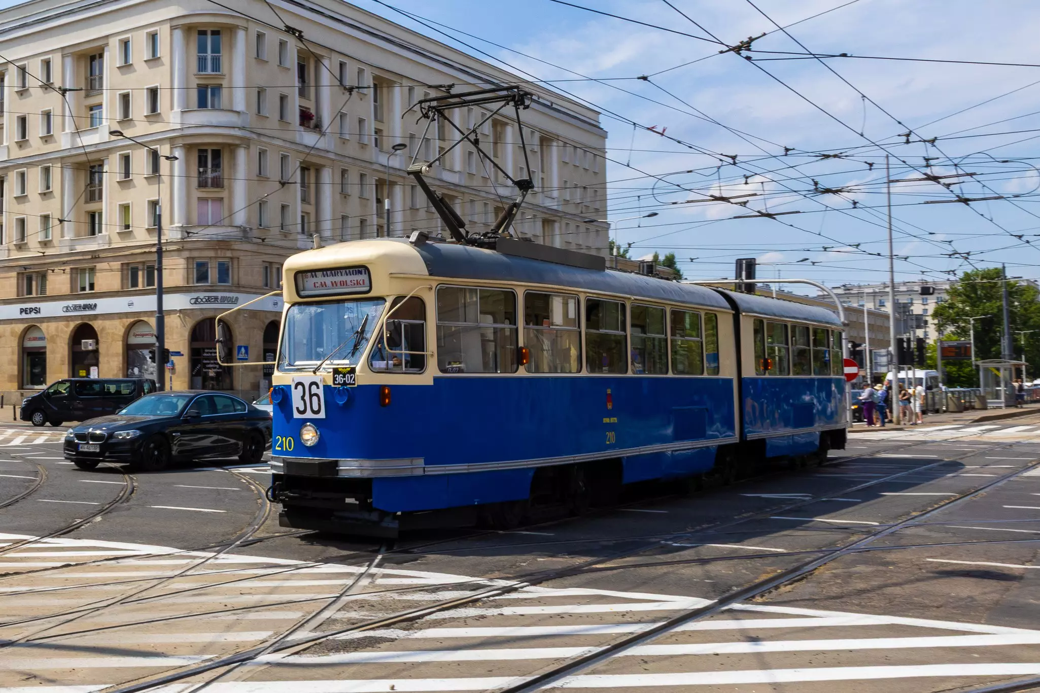
Take a tram in most parts of the city
Trams are the most convenient way to cross Warsaw. Over 30 lines operate between 6am and 11pm, running about every 10 minutes on average, so you’re never far from a ride.
Tram tickets can be purchased in subway stations and on board from machines that take both cash and tap credit cards. If you buy a ticket on board, it is validated at the time of purchase. Otherwise, be sure to validate your ticket using the smaller yellow machines on board.
Payment is on the honor system, however the fine for being caught without a ticket is 266zł (US$72), which can be reduced by 30% if it’s paid on the spot or within seven days. Don’t try to pull a runner; if a plainclothes ticket inspector asks to see your ticket, you must hand it over.
The majority of the trams in Warsaw are wheelchair- and stroller-friendly, with floors that align to the platform. However, a few older trams with tall steps are still in circulation.
On the weekends, the city runs special trams from the 1940s and 1950s along the tram 36 line, largely considered to be one of the city’s most historically significant routes, as it passes by Filtrowa St, the Warsaw Rising Museum and Wola Cemetery, among other must-see points of interest. These historic cars do not have ticket machines, and tickets have to be purchased via the mobiWAWA app or at ticket machines in subway or bus stations. The older trams are not suitable for those who cannot manage stairs.

The subway is fast but only goes to limited areas
The Warsaw subway is one of the most modern subways in Europe. Speeds top out at 90km/h (60mph). However, with only two lines, its coverage is somewhat limited.
Take the M1 (north-south line) to cruise along the Warsaw side of the river, including stops at Kabaty Woods (Kabaty), Old Town (Ratusz Arsenał) and the Palace of Culture and Science (Centrum).
The M2 (east-west) connects the Warsaw and Praga sides of the city, allowing for quick connections across the river. This will be your line for the Copernicus Science Center, Vistulan Boulevards (Centrum Nauki Kopernik) and Praga art mural district (Targówek Mieszkaniowy).
Buses cover the gaps in Warsaw
Warsaw has over 1500 buses, covering the majority of the city, including Warsaw Chopin Airport, which is accessible on the same basic timed ticket. Many lines run all night, making them a perfect ride home if you’ve been sampling Warsaw’s nightlife. Tickets are available for purchase from onboard machines or in subway stations. As with trams, if you buy a ticket on the bus, it is validated from the time of purchase, but otherwise you need to validate at a yellow machine on board.
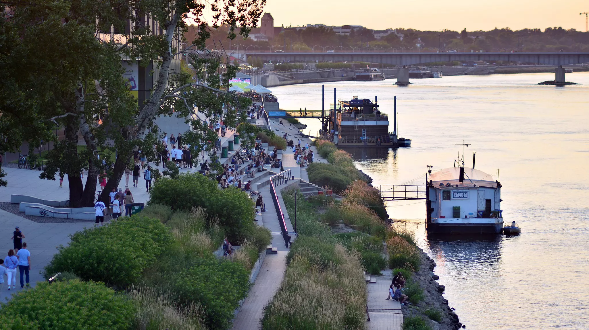
Take to the water
On weekends from May 1 through September 21, Warsaw provides three free water taxis across the Vistula River. While not the most efficient way to travel, it is one of the most enjoyable, particularly when the temperature rises. Cypel Czerniakowski (Warsaw side) is connected to Saska Kępa (Praga side); Most Poniatowskiego (Warsaw) connects to Stadion Narodowy (Praga); and Podzamcze (Warsaw) connects to Wilga (Praga). There are a few departures an hour – but check the website before your visit because the crossings are subject to the water level.
Ditch the car
Unless you’ve been recruited to help a friend move, avoid driving in Warsaw. Parking in central neighborhoods is extremely limited, and traffic in the city is the stuff of legend. (Some locals passionately argue that it’s the worst in Europe.) If you simply must travel by car, consider a rideshare service like Uber, Bolt or FreeNow. Bikes can also be rented through the Veturilo app.

Walk in central Warsaw
Warsaw is 518 sq km (200 sq miles) and is made up of 18 districts, so covering the whole city on foot isn’t an option. But within the more central districts, it becomes a stand-out walking city. Start in the Śródmieście district and walk from Old Town, past the Palace of Culture and Science and into Mokotów, an upscale neighborhood known for green spaces and its burgeoning cafe culture. Popular thoroughfares Nowy Świat and Krakowskie Przedmieście become pedestrian streets on holidays and every weekend from Saturday morning until Sunday evening. Cover the almost 6.5km (4 miles) of Vistulan Boulevards and stop for a drink or a snack at one of the many river clubs and cafes. Or cross from the Warsaw to the Praga side of the city via Warsaw’s first pedestrian bridge.
Plan your route
Google Maps is good for route planning, but sometimes there is a lag in announcements about transit delays and rerouting. Instead, use Citymapper for more up-to-date information, or the Polish app Jakdojade, which might be among the best. To plan trips and buy transit tickets, you’ll have to navigate to the language page and change it to English for full functionality.