10 beautiful Georgia hikes to keep you busy in every season


Georgia’s mountain hiking trails offer plenty of backwoods magic © Tony Barber / Getty Images
If you picture Georgia as peach groves and coastal swamps, you’re only getting half the picture.
The largest state east of the Mississippi River climbs to Appalachian heights in the north, where wild forested hills of Southern terrain are crisscrossed by incredible hikes that rival anything in neighboring North Carolina or more famous outdoorsy destinations such as New Hampshire and Vermont.
Best of all, with its mild climate, Georgia is open to hikers year-round. Spring and fall are famously lovely months for hitting the trail, but even in the depths of winter you can walk for miles at lower elevations without getting too frosty. Mountain-top vistas get even more impressive when the deciduous trees that dominate Georgia’s forests drop their leaves.
From the southern terminus of the legendary Appalachian Trail to spectacular waterfalls crashing into pools ringed by rhododendrons, from under-the-radar thru-hikes like the Pinhoti Trail to unexpected canyons carved by centuries of erosion, the Peach State is full of surprises.
Pet parents will also find much to love: dogs that are leashed (no longer than 6ft) and accompanied by their owner are permitted on trails at all Georgia state parks (with the exception of Tallulah Gorge and Panola Mountain).
So lace up your hiking boots and grab your trekking poles: from challenging trails with technical features to short day hikes easily accessible to families and hikers with disabilities, we’ve hand-picked some of the best hikes in Georgia.
The Pinhoti Trail: best hike for backpackers and thru-hikers
160+ miles (257+km) one-way in Georgia; 2–3 weeks; moderate to strenuous
Springer Mountain wasn’t originally intended to be the southern terminus of the Appalachian Trail. Benton MacKaye, the conservationist who came up with the idea for this continent-long thru-hike, imagined the trail would run the entire length of the Appalachian Mountains, including the rolling foothills that extend into portions of Georgia and Alabama.
Work began in the 1970s to blaze the Pinhoti Trail, covering the southern spurs left off the official Appalachian Trail, but it was only in the early years of the current millennium that the 160-mile pathway was completed and opened to hikers.
Today, Pinhoti is a destination hike in its own right and a good training ground for hikers headed further north on the Appalachian Trail. Some come for day hikes, but you can also make a long-haul backpacking trip by following the trail across Georgia from the Alabama state line near Etna to the northern terminus at Flagg Mountain, near Epworth.
Pinhoti is the Creek Indian word for “turkey’s home,” and diamond-shaped white tags along the trail are emblazoned with a print of a turkey foot. Rectangular white blazes also mark the trail in Georgia. The full length of the trail across Alabama and Georgia is about 355 miles.
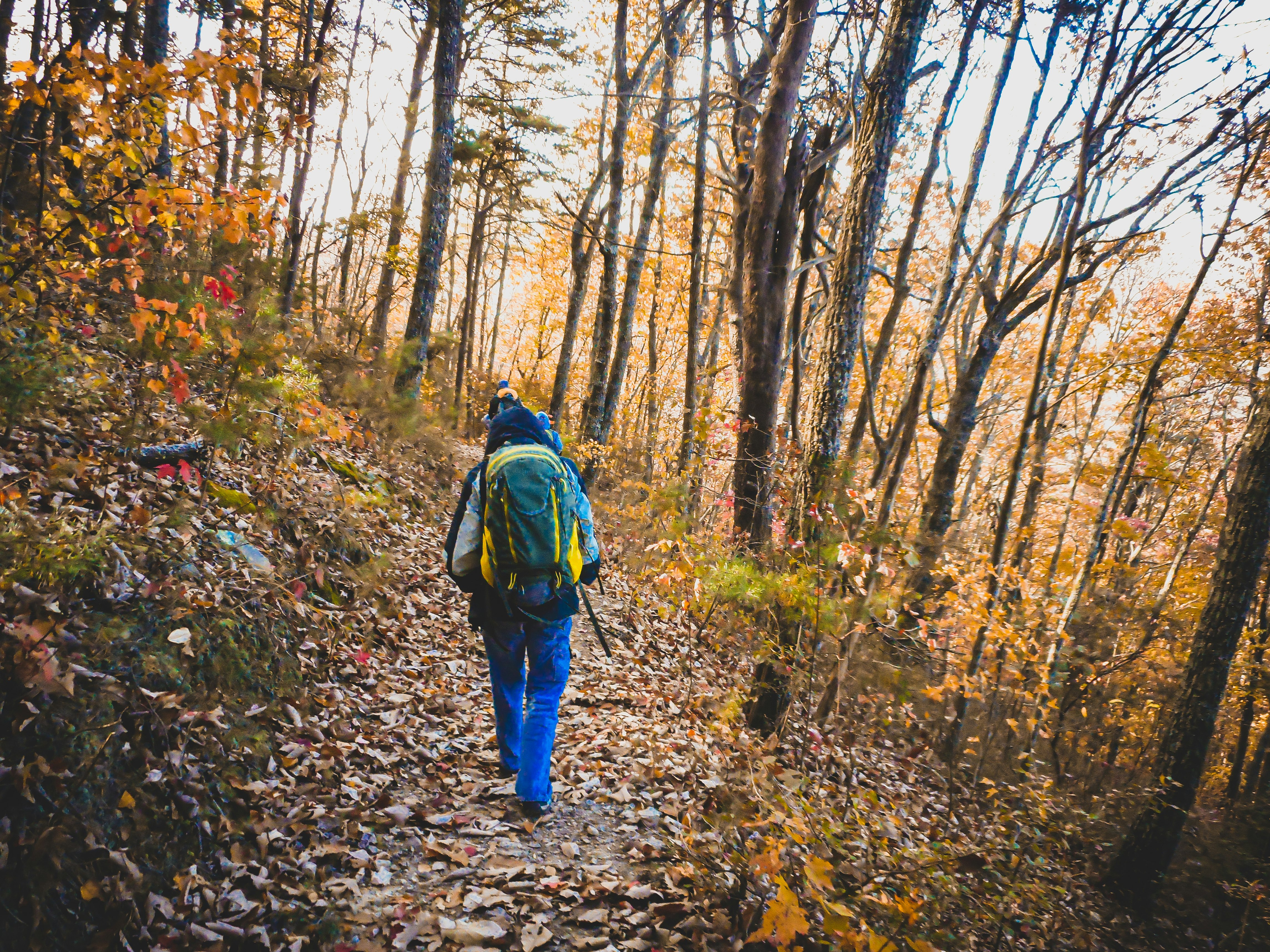
Blood Mountain: best hike for scenic views
4.3 miles (6.9km) roundtrip; 3 hours; strenuous
Despite the sinister-sounding name, the trek to the summit of 4458ft Blood Mountain is one of the most rewarding hikes in all of Georgia. This is the highest point on the Georgia section of the Appalachian Trail, with a peak that opens up to inspiring panoramic vistas (in contrast to the many other mountain trails in Appalachia that climb to anticlimactic high points hemmed in by dense foliage).
Pick up last-minute supplies at the legendary Mountain Crossings general store, then start your climb at the Byron Reece trailhead near Neels Gap. You can follow the blue blazes to the intersection with the Appalachian Trail at Flat Rock Gap, then the white blazes to the summit. You’ll know you're getting close to the top when the trees give way to a series of stony open areas that hint at the views to come.
Keep your glutes firing until you reach the big stone shelter built by the Civilian Conservation Corps almost a century ago, where Appalachian Trail hikers still rest up overnight.
You can scramble up the boulders behind the shelter for the best summit views and a bite to eat. (There’s a reason it's called Picnic Rock.) To keep the location pristine, look for an outhouse further down the trail and downhill from the shelter.
If you don't want to backtrack, you can turn your Blood Mountain hike into a 6-mile loop by continuing along the Appalachian Trail until you run into the Freeman Trail partway down the mountain. The path juts off to a sharp left and brings you back to the Byron Reece trailhead at a lower elevation.

Pigeon Mountain Pocket: best hike for outdoors folks with disabilities
.9 miles (1.4km) roundtrip; easy; 1 hour
If you're looking for wildflowers and waterfalls, it’s hard to beat this off-the-beaten-path walk in northwest Georgia. Tucked at the foot of Pigeon Mountain is a tiny jewel box of biodiversity. The trail features level boardwalks that float just above a sea of bloodroot, Dutchman’s breeches, trillium, Virginia bluebells and star chickweed.
Reached via the accessible, open-all-year Shirley Miller Wildflower Trail, this lovely patch of woodland is typically in bloom from March through May, though it’s pretty any time of year thanks to the bubbling Pocket Branch creek and the lovely, two-pronged cascade that splashes down from Pigeon Mountain.
Where the walkway ends, a trail leads to the base of the falls, though it’s fairly rocky, rooty and muddy; be careful to stay on the trail to protect the vegetation that makes this place so unique. And if you don’t mind getting wet, go all the way up behind the falls to peek at the arch-shaped passage in the rock behind the right-most cascade.
You’ll need to purchase a Go Outdoors Georgia hunting, fishing or lands pass license to explore the grounds. According to staff, the best license for hikers is the 1-day hunting-and-fishing combo, which is $5 for Georgia residents and $10 for non-residents.

Amicalola Falls: best hike for families
2.1-mile (3.4km) loop; moderate to strenuous; 1–2 hours
Tennessee has Fall Creek Falls, Oregon has Multnomah Falls, Washington has Snoqualmie Falls and Georgia has 729ft-tall Amicalola – the tallest cascade in the state.
Just north of Dawsonville, Amicalola Falls State Park not only boasts a waterfall but a popular lodge, restaurant and conference center, along with plenty of campsites and hiking trails (including a spur that connects to the Appalachian Trail). The park is about a 90-minute drive from Atlanta.
Hikers can get a close-up look at the falls on several trails, ranging from less than half a mile to just over 2 miles. The shortest is the West Ridge Trail, an ADA-accessible path that leads to the middle of the cascade and connects to two other paths offering views of Amicalola from above and below.
On the 2.1-mile loop hike, after kicking off beneath a stone archway behind the visitor center, you’ll have to conquer 604 steps to reach a viewing platform where you can see the falls from halfway up. The loop begins on the Appalachian Approach Trail, which climbs past the falls on its 8.5-mile run to the southern terminus of the Appalachian Trail atop Springer Mountain.
From the top of the falls, continue on the East Ridge Trail, which drops back to the visitor center parking lot. If you’d prefer to descend on the steps, begin this hike on the East Ridge Trail.
Cloudland Canyon: best hike for leaf peepers
5-mile (8km) loop; moderate to strenuous; 3–3 1/2 hours
Protected as a state park, Cloudland Canyon formed millions of years ago as Sitton Gulch Creek cut through the western edge of Lookout Mountain. Today, it’s full of lovely hiking trails and camping spots and is easily accessible from Chattanooga and Atlanta. What sets the park apart is the way the forested canyon shimmers in a fiery blaze of color every autumn. Check the park calendar for foliage hikes along the East Rim and the Georgia state park system’s Leaf Watch for updates about fall colors.
Some of the best vantage points are on the West Rim Loop Trail, a moderate to challenging 5-mile lollipop loop that takes trekkers up out of the gorge to the edge of the canyon.
You’ll pass through stands of rhododendrons and boulder fields, with plenty of overlooks gazing down on views that are just begging to be Instagrammed. It’s easy to turn this day hike into an overnight trip, as the trail passes the park’s yurt village, rental cottages and campgrounds.
You can combine the West Rim Loop with the Waterfalls trail to see Cloudland’s famous Cherokee Falls and Hemlock Falls. This strenuous hike to the base of the gorge and back only covers 1.8 miles but involves a climb back up 600 metal stairs.
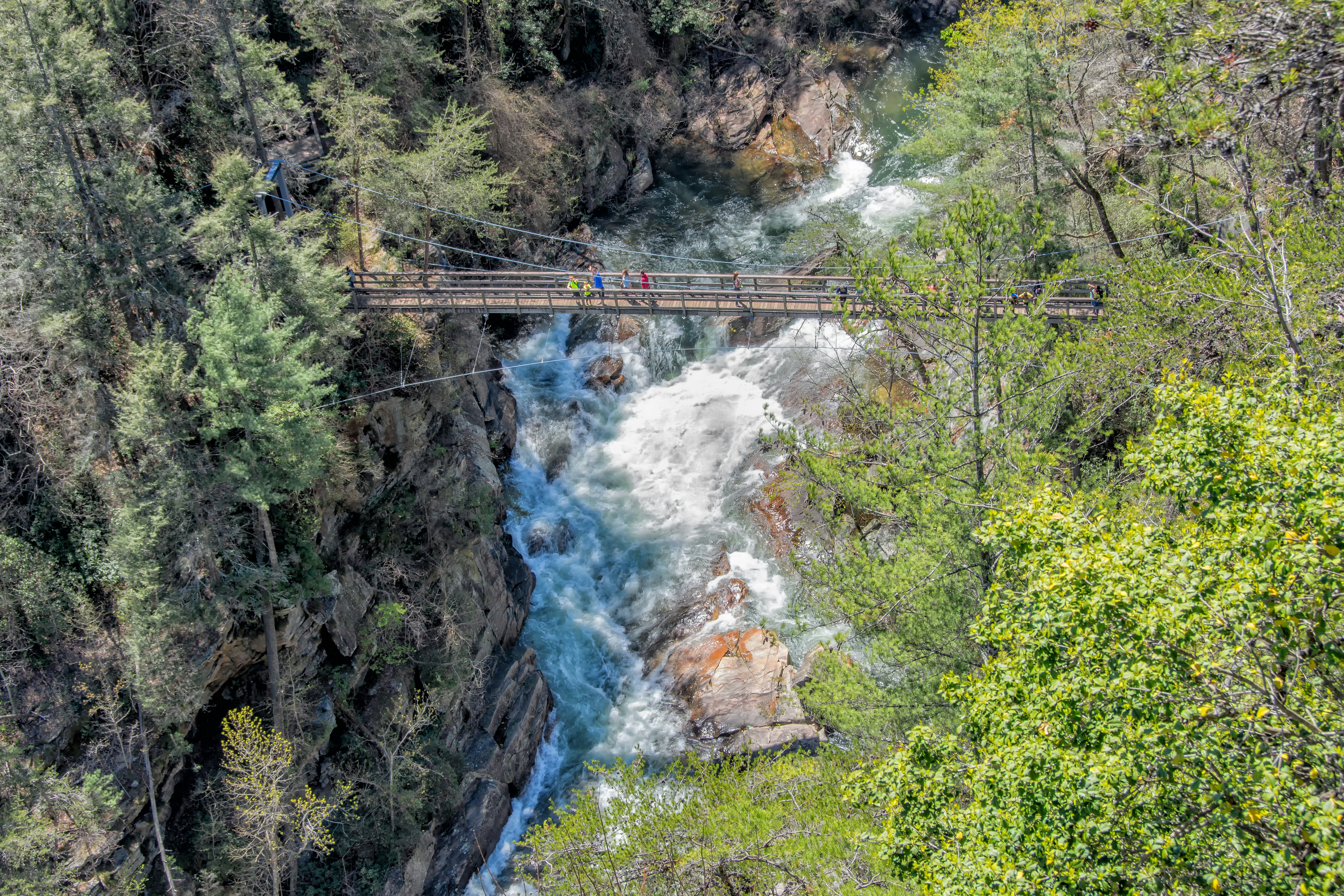
Tallulah Gorge: best hike for photographers
2-mile (3.2km) loop; strenuous; 2 hours
In the far northeastern corner of Georgia – about 100 minutes from Atlanta or 3 hours from Chattanooga – Tallulah Gorge is one of the state’s Seven Natural Wonders. Hikers can view the gorge’s natural delights up close on the gorgeous but strenuous Hurricane Falls Trail Loop, which links some of Georgia’s prettiest waterfalls, including L’Eau d’Or, Tempesta and Hurricane.
On a 2-mile round trip hike to the base of Hurricane Falls, you’ll follow the rim of this water-carved gorge, then descend to its bottom, even crossing an exhilarating suspension bridge that wouldn’t look out of place in an Indiana Jones flick. (In fact, this area does have a movie pedigree: several scenes from Deliverance were filmed here.)
There are 10 overlooks along the Hurricane Falls Loop, along with over a thousand heart-pounding stairs that will leave your quads shaking. But it’s all worth it for the classic Georgia hills scenery.
The 14 best free things to do in Georgia
Len Foote Hike Inn: best hike to see the sunrise
10 miles (16km) roundtrip; moderate; 2 to 4 hours
If you like the idea of backcountry hiking – except for the part where you schlep with days worth of food and sleep in rugged discomfort – try this famous hike that falls somewhere between backpacking and glamping. True to its name, the Len Foote Hike Inn in the Chattahoochee National Forest is only reachable via a 5-mile hike that takes anywhere from 2 to 4 hours.
Once you arrive, you’ll be greeted with rustic hospitality in the form of 20 private bunk rooms, hot showers, family-style meals, a library stocked with board games and puzzles, and lots of cozy nooks where you can curl up in an Adirondack chair and take in the backcountry mood.
Spectacular sunrises are the specialty of the lodge, which sits on a mountain ridge with a clear view east. A soft drum beat awakens guests 30 minutes before dawn, which gives them time to assemble on the viewing deck to watch the day begin.
Some hikers choose to pair a multi-night stay at the lodge with a trek to Springer Mountain, reached via a 9-mile round trip.

Providence Canyon: best hike for geology fans
2.5-mile (4km) loop, easy to moderate, 2 to 3 hours
Here, Georgia’s famous red dirt is transformed into an eerie canyon. Unsustainable farming practices over a century ago were responsible for creating the Peach State’s “Little Grand Canyon”: ditches cut by farmers into the soft soil were carved deeper by erosion, creating the intriguing gullies and gulches you’ll see today.
To explore, head to the easy-to-moderate Canyon Loop Trail, a 2.5-mile path that offers grand views down into the canyons numbered 1 to 9.
You can add another mile or two if you walk down into the canyons (but be ready for mud if you do, as the canyon floor tends to get quite soggy). There’s a 7-mile backcountry trail leading to primitive campsites and views of additional canyons for a gnarlier outing that’s both strenuous and technical.

Anna Ruby Falls: best hike for waterfalls
From .2 miles (.32km) roundtrip; easy; from 20 min
Twin waterfalls cascade through the foliage at Anna Ruby Falls, which is tucked away in the Chattahoochee-Oconee National Forests near charming Helen, Georgia.
The Anna Ruby Falls Trail is a smooth half-mile path from the parking lot to a pair of viewing decks, offering a good option for families and others who prefer to keep things short and easy. Though paved, this approach trail is not fully accessible as there are moderate inclines at a few points.
For a longer hike, try the Smith Creek Trail, a 9-mile round-trip trek through Unicoi State Park that ends at Anna Ruby Falls following a path originally blazed by early gold miners. Although it does not reach the falls, the paved Lion’s Eye Trail is punctuated with signage in braille about the surrounding landscape, with a handrail to guide visitors with visual impairments.
Appalachian Trail: best for sections and day hikes
78 miles (125.5km) one-way; moderate to strenuous; 8 days
Only 78 miles of the Appalachian Trail’s 2200 miles are in Georgia – but they’re pretty essential miles, connecting to the hike’s southern terminus atop 3780ft Springer Mountain.
They’re also incredibly scenic, straining up and down the stunning summits of Springer Mountain, Blood Mountain and Tray Mountain. Hike to the summit of Springer for fantastic views of the Appalachian’s fall foliage, typically from mid-to-late October,
Of course, you can hike all or parts of the Appalachian Trail all the way up to Maine. But you can also break up Georgia’s portion of the trail into a series of enjoyable day hikes or shorter backpacking trips linking major landmarks such as Woody Gap, Slaughter Mountain, Neels Gap, Gooch Mountain, Tesnatee Gap and Hogpen Gap.
If you want to pick up a map and get some advice, chat with the experts at well-regarded outfitter Mountain Crossings. The parking lot is a meeting point for both hikers and leather-clad bikers.
You might also like:
9 common mistakes to avoid while hiking and camping
7 expert tips for tackling your first multi-day hike
How one first-time hiker conquered the Appalachian Trail