

Find the perfect trail for you with this guide to Washington's best hiking routes © RyanJLane / Getty Images
With its impressive terrain of imperious mountains, volcano-ravaged landscapes and sumptuous rainforest, Washington state is understandably renowned amongst keen hikers.
It is home to the northern terminus of the Pacific Crest Trail (part of the "Triple Crown" of US hiking), the headquarters of the American Alpine Institute and three pioneering national parks: iconic Mt Rainier, the primeval Olympic peninsula and the lonesome mini-Alaska of the North Cascades.
When you’re done pacing the state’s saw-toothed mountains and rain-soaked forests, you can stroll the less threatening fields and hedgerows of the bucolic San Juan Islands, or warm down on the pleasantly paved (and accessible) Burke-Gilman trail in urban Seattle. These are the best hikes in Washington state.

1. The Wonderland Trail is a challenging multi-day hike
93-mile loop, 10–12 days, hard
Backcountry endurance athletes will love the Wonderland Trail, Mt Rainier's classic long-distance hike, a 93-mile pilgrimage that completely circumnavigates the mountain and logs a cumulative elevation gain of 21400ft. Conceived in 1915, the trail is well-marked and completed by between 200 and 250 hikers a year. Incorporating multiple ecosystems into its course, it reveals captivating vistas of Rainier and its 25 glaciers from every angle.
Longmire near Mt Rainier National Park’s Nisqually entrance is the most popular starting point for the multi-day extravaganza. Most hikers tackle the route in a clockwise direction in July or August after the snow has melted and the mountain’s famous wildflowers are in bloom. There are 18 backcountry campsites en route. Don't worry if you're new to backcountry camping and don't know where to start. Our handy guide will ensure you have the time of your life.
2. The Enchanted Valley Trail is the best hike for wildlife-spotting
27 miles round-trip, 2 days, easy
Billed as one of the easiest and downright charming ways to delve into the roadless interior of Olympic National Park, this gentle, easy-to-follow trail stretches for 13.5 miles from the Graves Creek trailhead to a large riverside meadow, the site of a handsomely mildewed wooden cabin dating from the 1930s. Much of the early miles are through a wooded valley studded with a magnificent old-growth forest and bisected by the gurgling Quinault River.
After passing the O’Neil Creek campsite, the trees slowly thin out to reveal sheer cliff faces and peaks rising 2000ft from the valley floor. During the spring snowmelt, the precipice is drizzled by innumerable waterfalls (locals claim there are 10,000!), while the valley is decorated with a rich rainbow of wildflowers. You can camp by the enchanting but closed-to-public cabin before hiking back the way you came. Berry-seeking bears, shy deer and herds of elk are common in these parts.

3. Ozette Triangle Trail is the best beach hike
9.2-mile loop, 5 hours, moderate
The northern half of Washington is characterized by its wild, storm-lashed beaches, many of them protected within Olympic National Park. For a taste of this remote, elemental coast, come to Lake Ozette, 31 miles southwest of the town of Clallam Bay. It’s the location of a 2000-year-old Ozette-Makah village uncovered during a Pacific storm in 1970 (most of the archaeological site was backfilled in the 1980s).
From the lake, you can follow the 3.3-mile Cape Alava Trail to the westernmost point of land in the Lower 48. The trail, much of it across a raised boardwalk, delivers you to a rocky weather-beaten beach speckled with islets and sea stacks. Turn south here and – tide permitting – traverse the beach for 3 miles. Rocks, sand and fallen trees make it tough going (check tide charts in advance) but, halfway along, you’ll stumble upon the Wedding Rocks, the most significant group of petroglyphs on the Olympic Peninsula.
Loop back to the Lake Ozette trailhead by following the well-marked Sand Point Trail that plunges inland from the beach, completing an almost perfect triangle.
4. Cascade Pass to Stehekin Valley is a hike to an off-the-grid village
23 miles point-to-point, 2 days, hard
Bereft of road connections to the outside world, the remote Cascadian village of Stehekin is reachable only by boat or seaplane – unless you’re up for a bold backcountry adventure on foot. Three main trails head south off Hwy 20 to converge on the isolated community. The quickest and most spectacular is the 23-mile hike over Cascade Pass (reached via a steep 3.7-mile climb from the Cascade River Rd) that follows the route of a former Native American trading path switching back to the 5392ft subalpine saddle. The area is the current focus of a national park revegetation effort.
After ascending to the pass, the path continues down the other side into the Stehekin River Valley, where it joins briefly with the Pacific Crest Trail before descending to High Bridge. From here, you can catch a four-times-daily (in the summer and fall season) shuttle bus for the last 11 miles into Stehekin. Numerous backcountry campsites are available en route.

5. Desolation Trail is a great route for literary enthusiasts
7.9 miles round-trip, 7 hours, hard
Loaded with historical and literary significance, the Desolation Trail up to Desolation Peak (6102ft) in the North Cascades takes you to a historic fire lookout, built in 1933, the one-time refuge of American Beat writer Jack Kerouac. He worked as a watchman at this remote spot during the summer of 1956. The shortest ascent to the lookout from Ross Lake follows a steep, strenuous trail that gains 4475ft in less than 4 miles. The reward is stunning vistas of the twin peaks of Hozameen and, perhaps, echoes of the literary inspiration that prompted Kerouac to write Desolation Angels and The Dharma Bums.
To complete the hike in a day, you'll need to catch a water taxi from Ross Lake to a trailhead on the lake’s upper eastern shore. Alternatively, the peak can be hiked via a longer 43-mile round-trip route starting from a trailhead at milepost 138 on Hwy 20.
6. Chain Lakes Loop has the best mountain views
7.1-mile loop, 4 hours, moderate
If you’ve grown tired of climbing through thick forests to peek-a-boo viewpoints, this hike will save you some grunt work. Set in a high alpine nirvana amid the lake-scattered bowls and slopes of Mt Baker and Mt Shuksan, the Chain Lakes Loop starts at Artist Point (5100ft) at the end of Mt Baker Hwy, enabling you to get above the treeline by car. It's important to check the weather before you set off – snow can keep the road closed until early July.
The hike itself follows a moderate, well-trafficked route that’s spectacular from start to finish. From the parking lot, it traverses the lava walls of Table Mountain before dropping down to pass a half-dozen icy lakes surrounded by huckleberry meadows. Iceberg, Hayes and Bagley Lakes all unveil their glassy beauty. In the background, you’re treated to intermittent snapshots of Mt Shuksan (9131ft), the peak that launched a thousand calendar spreads, and Mt Baker (10,781ft), northwestern Washington’s omnipresent sentinel and one of the snowiest places on earth.
After passing the Heather Meadows Visitor Center, take the Wild Goose Trail back to Artist Point.
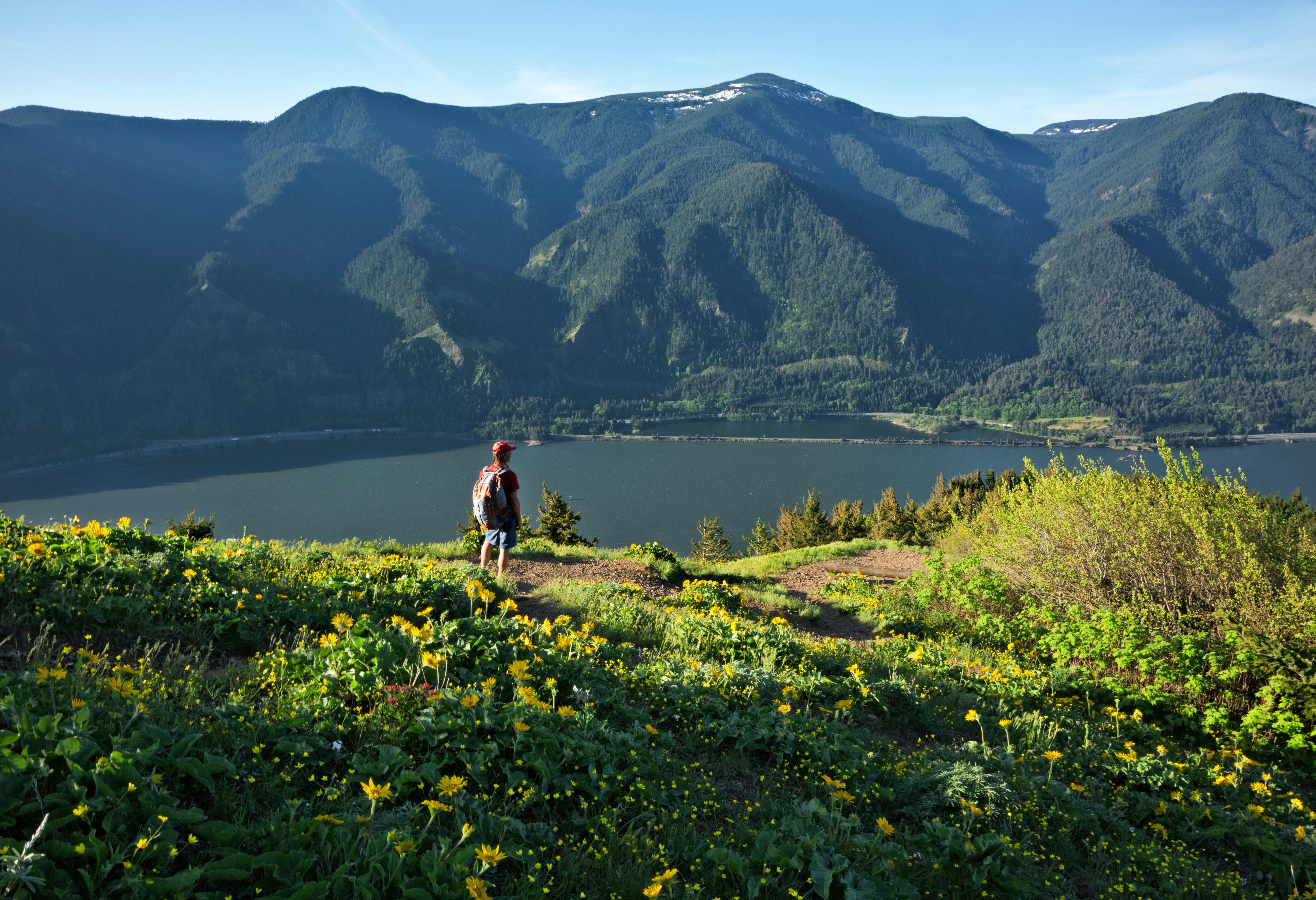
7. Dog Mountain Trail is the best hike for wildflowers
7.2 miles round-trip, 5 hours, hard
The toast of all Columbia Gorge hikes is a steep 3.8-mile climb up Dog Mountain, the best place in southern Washington for late-spring wildflowers. The uphill trek is unrelenting, but it ends in open fields full of balsamroot, paintbrush, lupine and more, framed by sweeping views over the mighty Columbia River, as wide as a lake at this point in its course. Oregon occupies the opposite bank and various Cascade volcanoes flash their brilliance in the distance.
The hike operates a permit system in the spring months to minimize crowds – book online in advance.
8. Bluff Trail is a good hike to do as a family
5.6-mile loop, 2 hours, easy
If your knees aren’t up to mountain scrambles or bushwhacking through Washington’s backcountry, try this bucolic stroll through a National Historical Reserve that embodies Washington state’s best parks, where the elevation change is minimal and the wildest animal you’re likely to see is a startled rabbit. Welcome to Ebey's Landing, a 17,000-acre patchwork of working farms, historic blockhouses and coastal bluffs spread across two state parks on the western shores of Whidbey Island, 30 miles north of Seattle.
The reserve’s best walk, the Bluff Trail, departs from the Sunnyside Cemetery just outside the historic town of Coupeville near the island’s narrowest point. The white hump of Mt Baker dominates the eastern horizon, and the peaks of the Olympics march away to the west as you head through wheat fields to a coastal bluff where the trail loops past wind-contorted trees and flower-covered slopes. Zigzagging down to a beach backed by a lagoon, the path doubles back on a parallel route to the start. Interpretive boards, wildfowl and marine ecosystems provide distractions en route.

9. Ape Cave is a great subterranean hike
3 miles round-trip, 2 hours, moderate
Tucked away in the forest on the southern side of Mt St Helens, Ape Cave is a 2-mile-long lava tube – the longest in the western hemisphere – formed around 2000 years ago in one of the volcano’s earlier eruptions.
It allows you to take an unguided cave walk up to 1.5 miles long (although there’s a shorter 0.8-mile option) and digest a bit of the area’s volcanic history as you go. Interpretive boards explain the basic geology, and forest rangers lead guided walks in summer. Bring good footwear, several torches/flashlights and a jacket (it gets cold even in summer).
Stairs aid entry to the cave but, once inside, passages are narrow and several lava falls must be climbed over, including one that’s 8ft tall. From the upper entrance, a forest path meanders 1.5 miles back to the parking area.
Planning tip: A permit system has been introduced to enter the cave, so book online before your visit.
10. Skyline Trail is the best route for glacier viewing
6.2-mile loop, 3.5 hours, moderate
Starting behind the historic Paradise Inn perched at 5400ft on the southern slopes of Mt Rainier, this gorgeous loop climbs approximately 1900ft, taking in the lofty lookout of Panorama Point, which provides some of the best views of Mt Rainier (in close-up), as well as the more distant Tatoosh Range.
Best done clockwise, the circuit incorporates glacier views, above-the-treeline paths patrolled by whistling marmots and expansive flower meadows replete with lupine, paintbrush, asters and bistort. Due to its famed beauty, the trail is well-signposted and trafficked. There are a couple of opportunities to cut corners and make the loop shorter.
Planning tip: Late July and early August are peak wildflower season and the best (but busiest) time to visit. Pick up a trail map at the Henry M Jackson Visitor Center next to Paradise Inn.
11. Heliotrope Ridge Trail is a top choice for glacier enthusiasts
5.5 miles roundtrip, 4 hours, moderate
Located on Mt Baker, Heliotrope Ridge Trail begins off Forest Road 39, where the dense forests quickly give way to expansive views of the surrounding peaks. Within 1 mile of a gentle ascent, you’ll cross the first of several small streams cascading down from nearby peaks and soon meander through wildflower-filled meadows, especially from late July to early August when the flowers are at their peak.
The moderate elevation gets more noticeable around the 2-mile mark, as you approach the treeline. The gain leads you gradually up to the edge of the Coleman Glacier, with blue ice caves offering a striking contrast to the surrounding landscape – you may even spot adventurous ice climbers making their way up the face.
12. Snow Lake Trail showcases the beauty of Alpine Lakes Wilderness
7.2 miles roundtrip, 3.5 hours, moderate
Within the Alpine Lakes Wilderness, Snow Lake Trail is a rewarding hike that provides picturesque lake views. The trail begins at the Alpental parking area near Snoqualmie Pass, immediately diving into a forested path lined with towering evergreens and dense undergrowth. The trail descends toward the lake and levels out around the 3-mile mark.
The lake is an ideal spot for a lunch break or a snack, and in the late summer months, you may even spot wild blueberries along the trail for delicious foraging. If you have the energy, continue past Snow Lake to Gem Lake, just over a mile walk, for a quieter spot.
13. Ptarmigan Traverse is Washington’s toughest hike
35 miles point-to-point, 5–7 days, extremely hard
If you’re a serious hiker with days to commit, the Ptarmigan Traverse is a legendary route winding through the Washington Cascades with some of the state’s most difficult and remote alpine terrain. This epic 35-mile trek, often described as Washington’s most grueling hike, requires a high level of mountaineering skill, route-finding expertise and experience with glacier travel.
The journey begins near Cascade Pass in North Cascades National Park and covers dramatic landscapes marked by towering peaks, steep inclines and expansive glaciers. The first major ascent takes you over Cache Col Pass, then traverses multiple glaciers, including the Dana, Middle Cascade and LeConte.
One of the most stunning sections is White Rock Lakes, where clear blue lakes reflect the jagged peaks that tower overhead, offering a backdrop for those able to reach this remote spot. The final portion of the traverse brings hikers over Spire Col and Dome Peak, two of the highest and most challenging points on the route.
14. Aasgard Pass is Washington’s toughest one-day hike
12 miles roundtrip, 8–12 hours, extremely hard
If you want to tackle a tough hike but only have a day to commit, the Aasgard Pass in the Enchantments Core Zone is hailed as Washington’s most difficult one-day hike, testing even the most experienced hikers. Starting at the Stuart Lake Trailhead near Leavenworth, this hike offers stunning rewards but demands intense effort.
The initial portion leads through lush, forested trails, climbing steadily until reaching Colchuck Lake at around 4 miles. From there, you’ll confront Aasgard Pass head-on. This brutally steep ascent climbs 2000ft in less than a mile. Snow patches here can linger well into summer, adding to the difficulty and unpredictability. But when you reach the top, you are rewarded with an entry into the Enchantments Basin, filled with sapphire-blue lakes, wildflower-dotted meadows and the occasional mountain goat roaming freely among the granite.
15. Rattlesnake Ledge is the best hike for beginners
4 miles roundtrip, 2 hours, easy
Still, Washington offers a number of trails that introduce newcomers to hiking in the state. One of the top trails for beginners is Rattlesnake Ledge, located in Rattlesnake Mountain Scenic Area near North Bend. The trailhead starts at Rattlesnake Lake and begins with a gentle incline, winding through a dense, shaded forest of towering cedars and firs.
The well-marked trail continues to climb gradually, providing several spots to stop and rest along the way. At around 1.5 miles in, the trail steepens slightly but remains easily navigable, with switchbacks helping to ease the climb. The path is wide, well-trodden and lined with ferns and moss until you reach Rattlesnake Ledge’s rocky outcrop. From here, enjoy the sweeping views before retracing your steps back.
16. Hurricane Hill Trail is the best hike in Olympic National Park
3.2 miles roundtrip, 1.5–2 hours, easy to moderate
For the best hiking in Olympic National Park, Hurricane Hill Trail is one of the state’s most-visited trails. Starting near the temporary Hurricane Ridge Visitor Center (the permanent building burned down in 2023), this hike takes you along a paved path that gently climbs through alpine meadows filled with wildflowers during the summer months.
The hike begins with a moderate ascent, but the well-maintained trail and gradual incline make it manageable even for beginners. After 1 mile, you’ll reach a ridge with views of the Olympic Mountains – on a clear day, you can even see as far as Vancouver Island.
Keep planning your trip to Washington state
Everything you need to know before visiting Washington state
12 of the best things to do in Washington state
Getting around Washington state