6 of the best hikes in Utah
Apr 23, 2024
10 MIN READ

Writer
Bryce Canyon offers some of the most epic landscapes in Utah © Shutterstock / Diegomezr

Writer
Lonely Planet may earn a commission from affiliate links on our site. All recommendations and reviews reflect our own independent opinions.
If you're looking for a new outdoor adventure and you want to go big, go to Utah. This state is made for hikers and epic adventures.
It's an easy landscape to love: red-rock mesas thrusting above mighty rivers, vertiginous treks teetering along knife-edge ridges, and tracks leading ever deeper into skinny slot canyons that elemental forces have carved out since dinosaurs roamed the earth.
Check out our list of the best places to explore Utah's wild and ragged backcountry.
1. Peekaboo Loop Trail
Best hike for a day trip 5. 5 miles roundtrip, 3-5 hours, difficult
An ideal day hike, Peekaboo Loop Trail sees the most variety of terrain and scenery in Bryce Canyon National Park, with 1500 to 1800ft of cumulative elevation changes.
Access to this circular trail is via either the Navajo Loop or the Queen’s Garden Connecting Trail, which runs off the Queen's Garden Trail. The following description starts from Bryce Point – if starting from Sunrise Point it’s a 6. 6-mile hike; from Sunset Point it’s 5 miles.
The Peekaboo Loop Trail is also a horse trail, so expect to see occasional riders. They move slowly, so you’ll have plenty of advance warning. Stock animals have right of way – step off the trail and let them pass undisturbed. If you don’t want to navigate around horse droppings, consider another route. But views here are among the park's best, particularly of the Wall of Windows, the Silent City and the Fairy Castle. You’ll also find shady spots to rest, a picnic area and pit toilets (the latter are on the loop, just west of its intersection with the connecting trail to Bryce Point, and only open during summer).
This trail rises and falls many times; be prepared for a workout. If you’re afraid of heights, be forewarned that in places you’ll pass sheer drops, though the trail is comfortably wide enough for a horse.
2. Grand Wash Trail
Best hike for beginners 4. 4 miles roundtrip, 45 min-1. 5 hours, easy
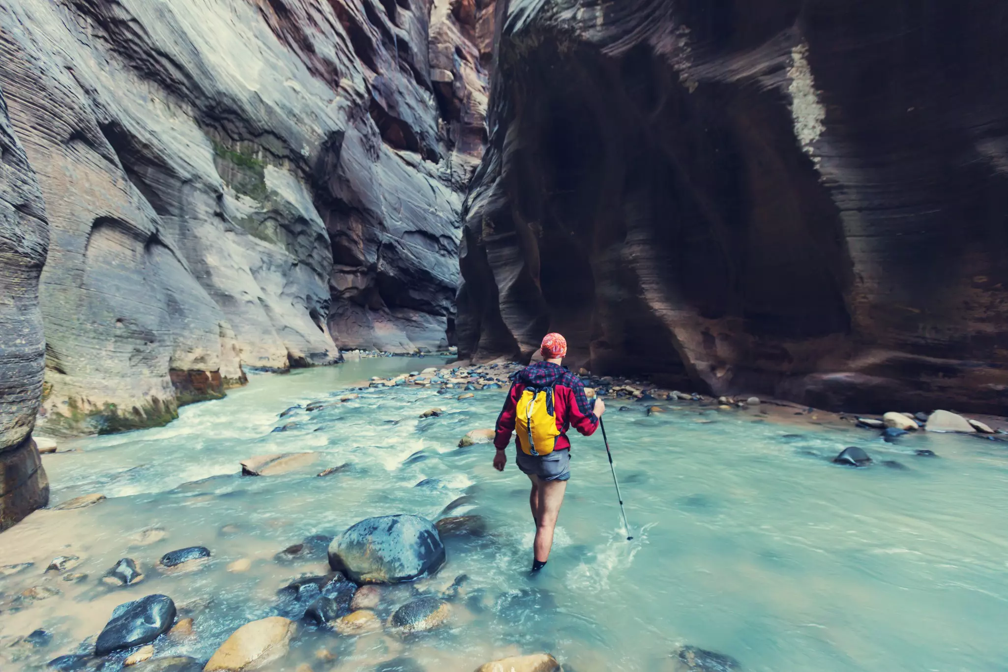
Capitol Reef National Park’s most dramatic canyon is worth visiting just to walk between the sheer walls of the Narrows. Avoid this hike if rain threatens, as the wash is prone to flash floods.
Start from the parking lot at the end of the Grand Wash spur road. It’s a leisurely stroll up the packed-sand wash from the parking area. Look for seasonal wildflowers such as reddish Indian paintbrush, shrubby white-flowering Apache’s plume and stalky, yellow-flowering prince’s plume. The canyon’s walls inch closer and closer together until, about 1. 25 miles from the trailhead, you reach the Narrows, where the 80-story canyon is just 15ft wide – a thrilling sight. The canyon walls shrink and spread out again as the flat trail approaches Hwy 24. Return the way you came, or arrange for someone to pick you up on Hwy 24, around 4. 5 miles east of the visitor center (look for a trailhead marker on the south side of the highway, where there’s a small gravel pull-off).
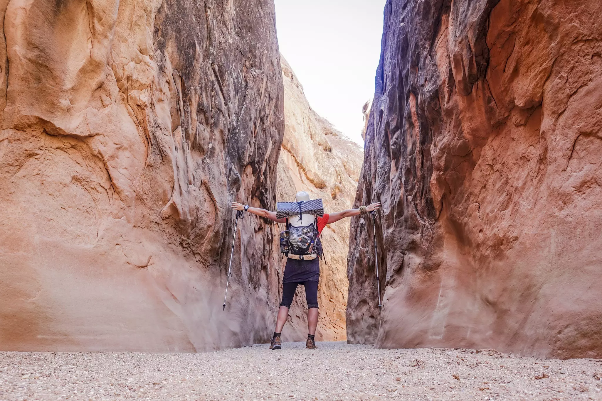
3. Chesler Park/Joint Trail Loop
Best overnight hike 11 miles roundtrip, 1-2 days, moderate overnight hike, moderate-difficult day hike
This trail, located in Canyonlands National Park, loops across desert grasslands, past towering red-and-white-striped pinnacles and between deep, narrow slot canyons, some only 2ft across. It also gives a great perspective on the Needles. Elevation changes are mild, but the distance makes it an advanced day hike.
Keep in mind that you won’t find any water. The Trails Illustrated Needles District map should suffice for most hikers, but if you’re inclined to wander, carry a 7. 5-minute USGS map.
Park at the Elephant Hill trailhead, three miles from Squaw Flat Campground. The trail climbs to a bench from the parking area, then undulates over slickrock toward rock spires. The next section is typically where people make a wrong turn. Cross the wash at the T-junction and follow signs to Chesler Park (not Druid Arch), descending 300ft along switchbacks into Elephant Canyon. Continue to follow signs along the canyon floor.
The final 0. 2 miles to the Chesler Park Viewpoint climbs 100ft, topping out on the rocky pass amid spires 2. 9 miles from the trailhead. This marks the beginning of the 5-mile Chesler Park Loop. Five campsites lie southeast of the junction.
The next morning, leave your backpack at the campsite and explore the claustrophobia-inducing Joint Trail, where the fractured rock narrows to 2ft across in places; the trail junction lies to the south, about midway around the Chesler Park Loop. Pause just east of the Joint Trail for stellar views of the towering pinnacles that ring Chesler Park. On the southwest section of the loop, you’ll follow a half-mile stretch of a 4WD road. If staying two nights, take the side trip to Druid Arch.
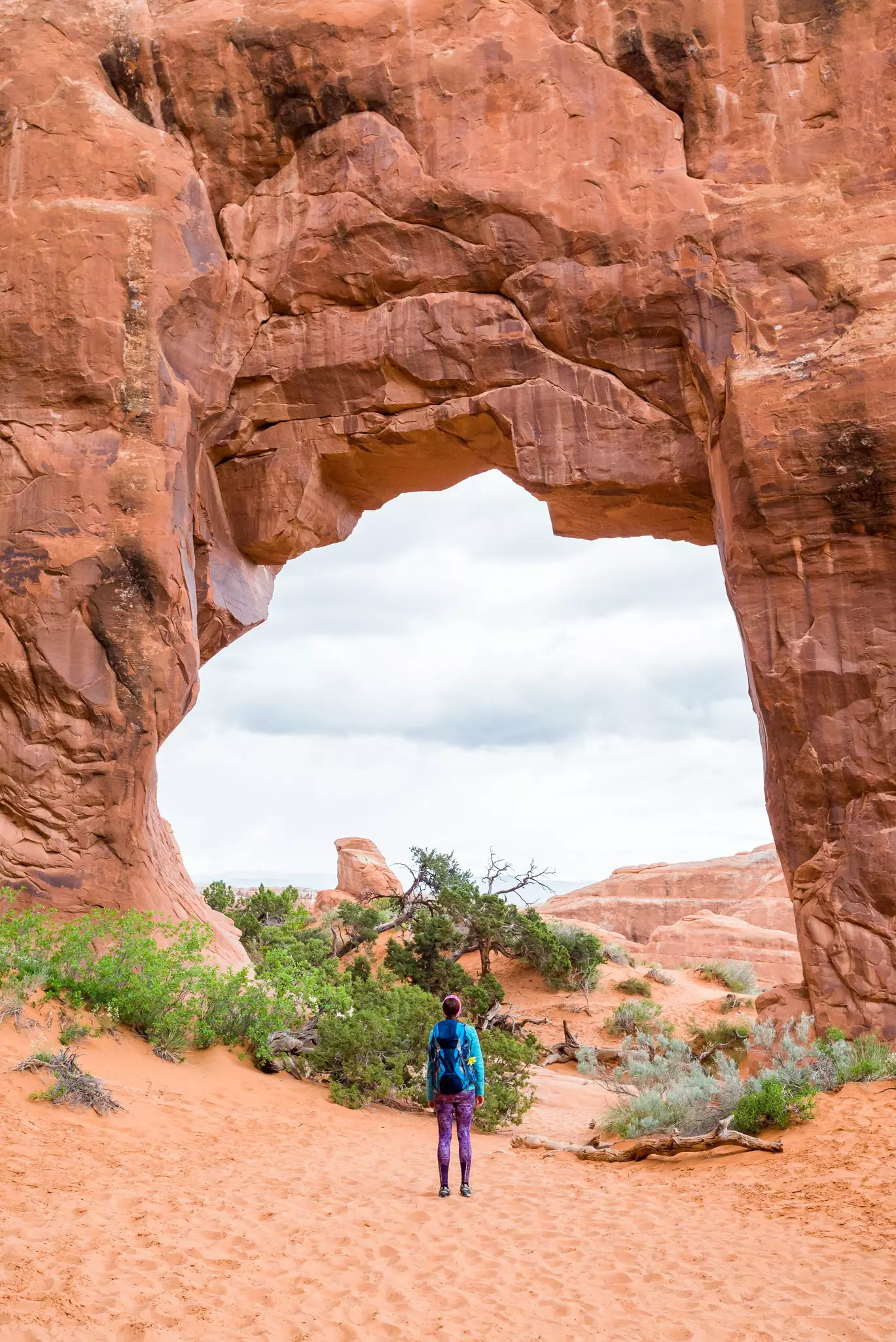
4. Landscape Arch
Best hike for families 1. 6 miles roundtrip, 30 min to 1 hour, easy to moderate
Among the world’s longest natural stone spans in Arches National Park, Landscape Arch is a spectacular ribbon of rock reached via a moderate gravel trail with spurs of interest.
Landscape Arch lies 0. 8 miles along the Devils Garden trail at the northern end of the main park road. Along the route, don’t miss the short spurs (0. 5 miles) to Tunnel and Pine Tree Arches. From the trailhead, you’ll thread through sandstone fins that stand on end like giant wedges. A third of a mile in, bear right at the fork and head downhill to Tunnel Arch (on your right) and the 45ft Pine Tree Arch (on your left). High on a cliff, aptly named Tunnel Arch looks like a subway tube through the Entrada sandstone. In contrast, Pine Tree Arch is meaty, with a bulbous frame around its gaping middle. Look for the gnarled namesake juniper, which juts from the base of the window.
As you approach Landscape Arch along the main trail, the terrain opens up, revealing long views to distant ridges and a vast expanse of sky. In the past, visitors could hike right beneath the elegant 306ft sweep of desert-varnished sandstone, longer than a football field. But in 1991, a 60ft slab of rock fell from the arch, nearly killing several hikers. When you notice the cracks on the left side of the arch, it’s easy to understand why the National Parks Service (NPS) closed the trail.
Facilities include restrooms, picnic sites and drinking water.
5. Lower Calf Creek Falls
Best hike to see a waterfall 6 miles roundtrip, 4 hours, moderate
The sandy track at the Grand Staircase-Escalante National Monument eventually follows a year-round running creek through a spectacular canyon before arriving at a 126ft waterfall, a joy on a hot day.
Lower Calf Creek Falls’ beauty is no secret; this is easily the most heavily traveled trail in the entire monument. Its accessibility – right off Hwy 12 between Escalante and Boulder – makes it a perfect stopover. Though it doesn’t climb much, the trail has long sandy stretches that can take a lot out of you. Carry plenty of water (available at the trailhead); the creek is not safe for drinking.
Park at the Calf Creek Recreation Area (day use $5) and campground, between mile markers 75 and 76 on Hwy 12. As you work your way toward the creek, you’ll pass honeycombed rocks and Navajo sandstone domes, an 800-year-old Native American granary, a box canyon where calves were once herded (hence the name Calf Creek), prehistoric pictographs and lush green wetlands.
Past the last bend, the trail ends in an amphitheater of rock with a 126-foot-tall waterfall with a thin stream cascading into a large pool. The sandy shore and extended knee-deep wading area, before the deeper drop-off, make this a favorite with families. Remember, the sandy walk out is as strenuous as the walk in, so pace yourself.
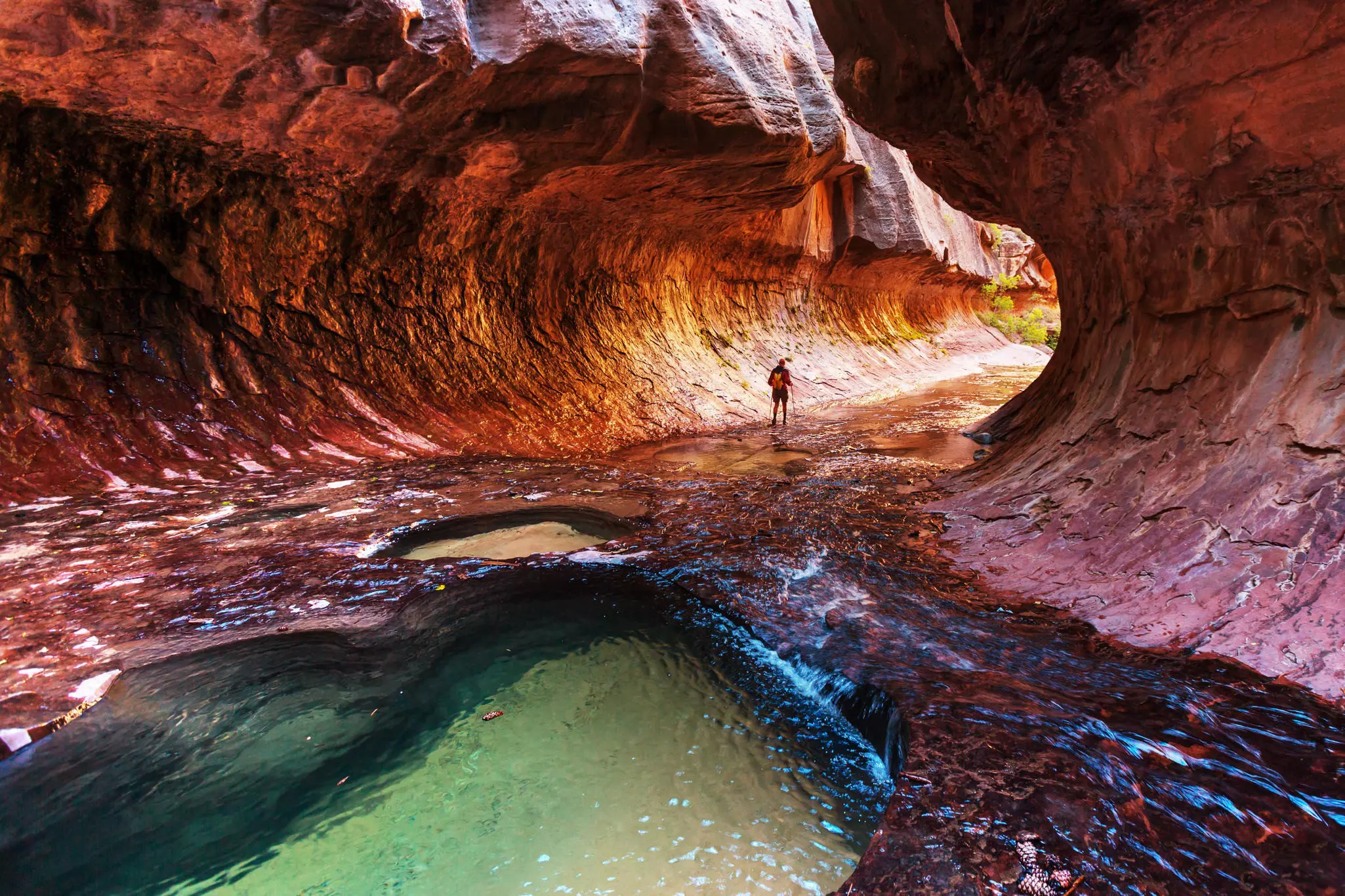
6. The Narrows: From the bottom
Best hike for adventure Up to 10 miles roundtrip, up to 8 hours, difficult
Hiking through a fast-flowing river in knee- to chest-deep water, the canyon walls seem to grow and press in on you: this is arguably the quintessential Zion National Park experience. Although some hikers will want to do the full overnight trip beginning at the top, if you hike up from the bottom, you don't need a permit and you can still reach the narrowest and most spectacular section. If you trek the entire 5 miles to Big Springs (as far as day hikers are allowed), you'll outpace most of the day-trippers – but don’t underestimate the distance: this is a long way to hike upstream.
The "trail" begins at the end of the Riverside Walk, where you enter and start following the river. Around the first bend you'll find Mystery Falls, the exit point for Mystery Canyon. You may catch canyoneers on their last rappel here. As you hike, each alcove, bowl, hollow, crack and arch seems its own secret place. Ravens glide low over the water, and you can sometimes hear waterfalls spilling down from inside the rock.
It’s about 2. 5 miles to the junction with Orderville Canyon, which is another popular canyoneering route. If you have time and energy, don't miss the side trip up the smaller and narrower Orderville. It’s possible to follow the canyon half a mile upstream to a waterfall, beyond which you’ll need a permit. (There are several small falls before this; you'll know you've reached the main one when you see a park service sign or by the simple fact that it is impassible to most.) However, there is an admission price of sorts to the canyon: about a quarter-mile upstream is a small pool that you’ll need to swim across to continue.
Past Orderville Canyon is the famous Wall Street, where the sheerness, nearness and height of the cliffs shatter whatever remains of your perspective. After this section, the canyon opens slightly again, the water gets periodically deeper (usually requiring swimming in places), and your fellow hikers thin out.
After the 4-mile point, you’ll negotiate a series of huge boulders, and the canyon, though gorgeous, becomes somewhat less otherworldly. At 5 miles you come to Big Springs, a fern-fringed rush of water much larger than anything so far. Here day hikers are required to turn around.
While it can take up to eight hours to do the full round-trip to Big Springs, set aside a minimum of five hours so you’ll at least have time to reach Wall Street. Don’t forget you also have to hike the Riverside Trail back to the Temple of Sinawava.
Tips for hiking in Utah
Since 2022, there's been a timed entry system at Arches. Officials haven't confirmed if it's permanent yet despite it's return every season since, but if you're visiting anytime between now and October 21, 2024 - we recommend reserving a spot online.
Check the websites for Visit Utah and the National Park Service for maps and details on trails, permits, getting around and weather conditions. Park visitor centers can advise on trails and help arrange permits for backcountry hikes. The majority of trails are marked with cairns and signed at intersections. Advance reservation is essential for campgrounds in season (generally March to October). Hiking is possible in summer when temperatures can reach 100°F (38°C), but try to avoid the midday heat and carry sufficient water and sunscreen.