These 7 hikes reveal Bora Bora beyond the beaches
Jan 2, 2025
8 MIN READ

Writer
Highlights
Writer Jessica Palmer maps seven hikes through Bora Bora's jungle and mountain interior.
Faanui, Point Fitiuu and Farepiti Cannons reward short climbs with WWII history and lagoon views.
Valley of the Kings passes ancient marae and a banyan tree said to inspire Avatar.
Summit Mt Pahia, rope up for Mt Otemanu or walk the 32km Bora Bora Loop.
Above Bora Bora’s famous beaches, trails through the jungle and up steep peaks beckon. Frederick Millett/Shutterstock

Writer
Highlights
Writer Jessica Palmer maps seven hikes through Bora Bora's jungle and mountain interior.
Faanui, Point Fitiuu and Farepiti Cannons reward short climbs with WWII history and lagoon views.
Valley of the Kings passes ancient marae and a banyan tree said to inspire Avatar.
Summit Mt Pahia, rope up for Mt Otemanu or walk the 32km Bora Bora Loop.
Lonely Planet may earn a commission from affiliate links on our site. All recommendations and reviews reflect our own independent opinions.
Most visitors head to Bora Bora for a blissful island vacation that centers around relaxing in an overwater bungalow on the sparkling lagoon. So you may be surprised to learn that it’s possible to work up a sweat with a vigorous hike on this gem of French Polynesia.
Given its small size and mountainous, jungle-covered interior, you really don’t have to venture far to feel like you’ve left civilization behind on Bora Bora. The payoff to any sweaty trek? Your astonishment at just how many different shades of blue you can see from your viewpoint as you gaze out on one of the world’s most beautiful lagoons.
Here are seven ways to make it happen.
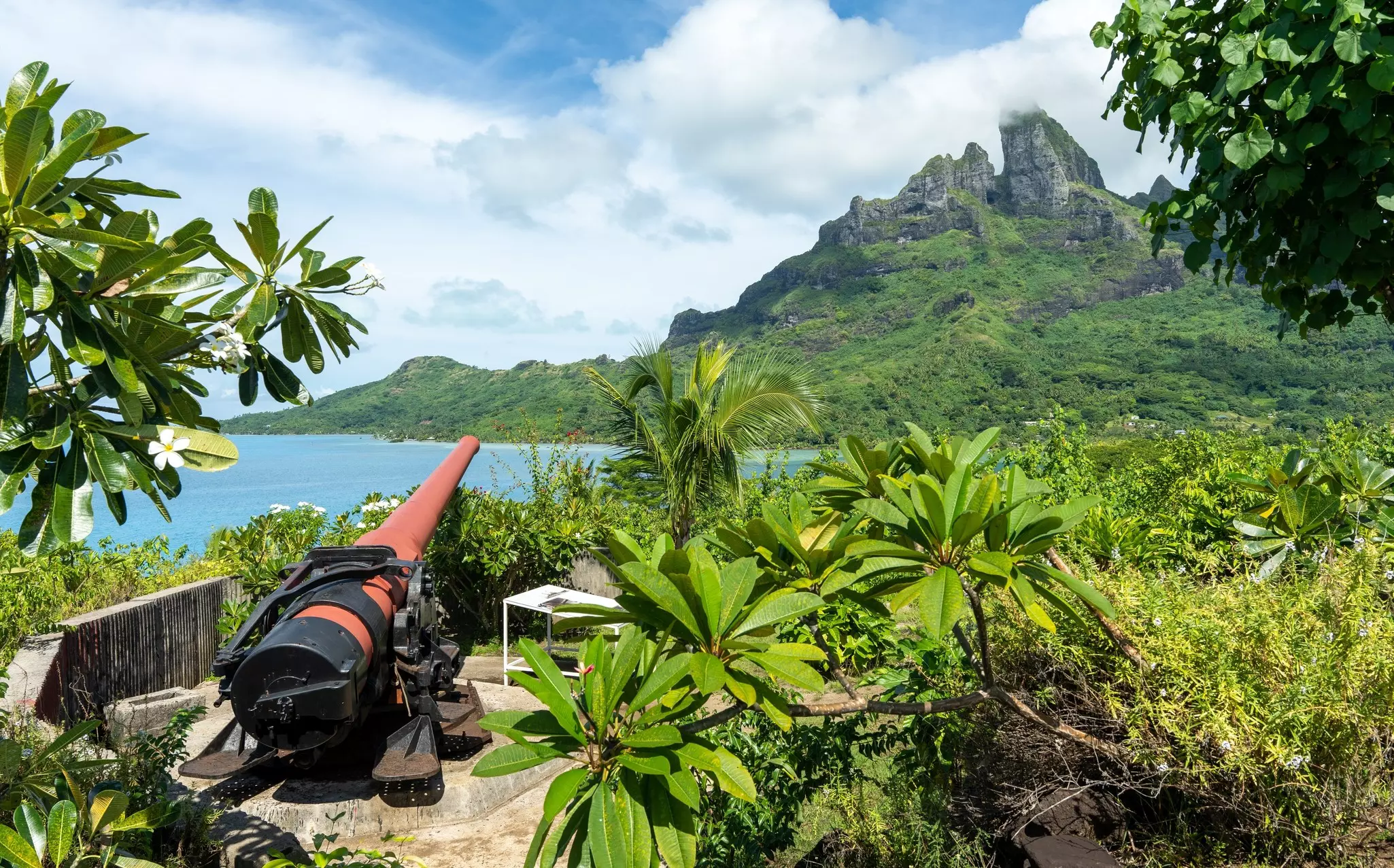
1. Faanui Cannons
Best short hike
Less than 300m (0.25 mile), 10 minutes, moderate
During WWII, the USA chose Bora Bora as a strategic military supply base – and, as on many South Pacific islands, decided not to take the big stuff home. At four locations in Bora Bora, eight giant cannons were installed high on the hills, and they remain there today. Some are difficult to find, but they’re waiting to be discovered. If you are willing to explore a bit, that is.
Anyone who finds the Faanui Cannons will enjoy spectacular views of Bora Bora’s iconic lagoon as a reward. Once you leave the sealed circle island road, it will take around 10 minutes of uphill walking; views of the motu (little islands) in the lagoon serve as a welcome distraction from your burning calves. As will the satisfaction of actually finding the cannons (even if one of the barrels has gone missing).
Trailheads are notoriously hard to find in Bora Bora due to a lack of signage. Yet the Faanui Cannons can be found on Google Maps, near Tereia Point in the northwest of the main island. Heading clockwise on the circle island road, make your way to the Pearl Beach Resort ferry departure (lagoon side of the road) a few kilometers past Faanui. Once you spot the sign to the ferry, the track to the cannon site is about 30m (98ft) further up the road on the right.
2. Point Fitiuu Cannons
Best hike for picnicking with a view
Around 1.2km (¾ mile) round trip, easy
Hikers seeking the well preserved Point Fitiuu Cannons – in Anau, on the eastern side of the main island – will be treated to stunning views of both Mt Otemanu and that magnificent lagoon (again!). Partway along this walk, an interestingly shaped geological feature juts dramatically out of the ground: it’s commonly known as Hiro’s Finger. (Some describe it using another part of the male anatomy.)
Take a picnic and make a morning or afternoon out of it, making use of the simple benches at the cannons. While snacking, you'll notice that one of the guns faces the Four Seasons Resort and the other faces Mt Otemanu.
The trailhead can be a little tricky to find. The easiest way is to head toward Point Fitiuu on the main circle island road, where you’ll soon find yourself heading up a small hill as you near it on Google Maps. At the sharp bend in the road, views of Mt Otemanu will come into sight, and you’ll see a track leading out onto the peninsula. The trail starts behind a cement building on private land. If the owners are about, you’ll need to ask their permission to cross their land.
3. Valley of the Kings
Best hike for Polynesian history
Around 3 hours, easy to moderate
It’s said that the giant banyan tree you’ll spot on this hike was the inspiration for the “Tree of Souls” in the blockbuster Avatar movie. Whether or not that’s true, there’s no doubt the tree has great cultural significance, since it’s said to serve as the final resting place of Bora Bora’s ancient kings.
The Valley of the Kings hike is best taken with a guide – not just because hikes on Bora Bora are rarely signed, but because this particular trail passes by relics of the island’s early history. Hikers can explore remnants of ancient villages and marae (Polynesian temples), which only expert guides will be able to point out.
You can also enjoy opportunities to eat the island’s bounty straight from the tree – and, of course, take in those iconic views of the turquoise-blue lagoon.
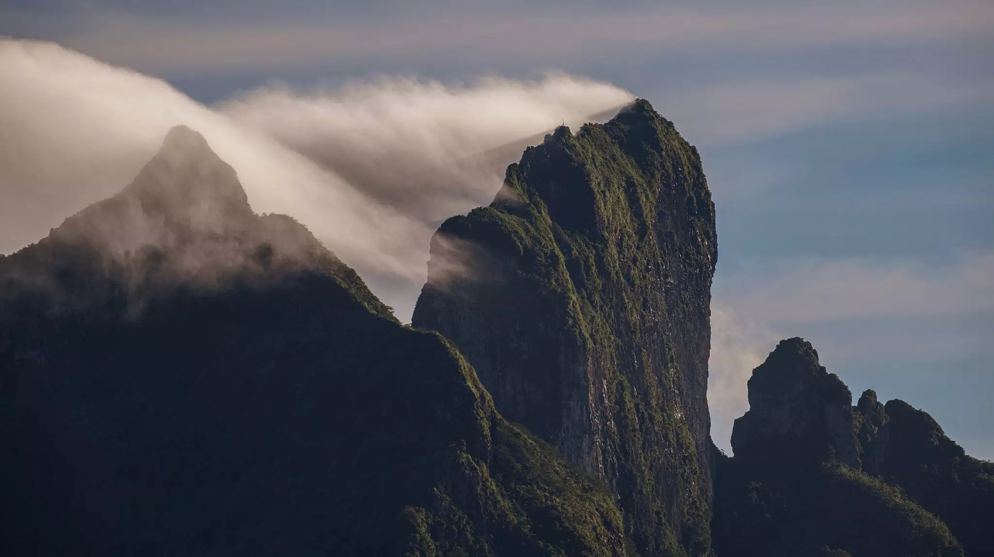
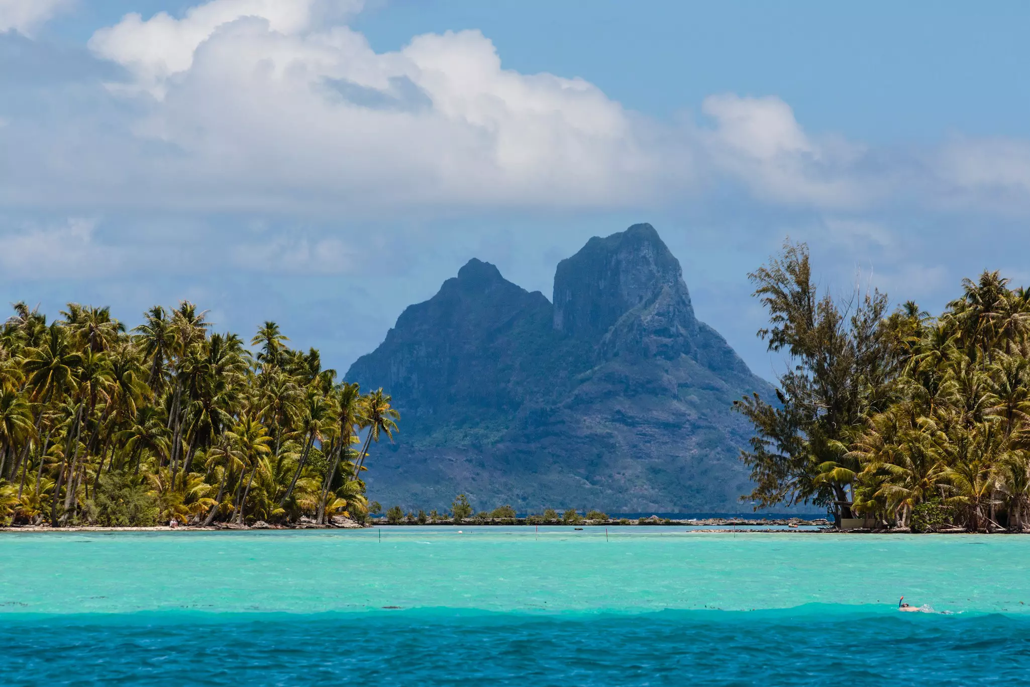
4. Mt Otemanu
Best hike for bragging rights
Around 6 hours round trip, difficult
Can you hike Mt Otemanu? As soon as hikers eye this craggy peak, the question immediately occurs. As the highest feature on Bora Bora, Otemanu dominates the landscape – and given its prominence on both travel brochures and the feeds of nearly every social media influencer who visits, it’s possibly one of the most recognized geological features in all of French Polynesia. Who wouldn’t want to brag about conquering it?
Hikers can’t physically get to the very top of the mountain’s 727m (2385ft) summit, as the towering twin peaks are both crumbly and vertical. Yet it’s still a hard slog just to get to the “shoulders” of the mountain, with a few sections requiring the ability to heave yourself up via strategically placed ropes.
The cave on Mt Otemanu’s northeastern side is not to be missed. Said to be a final resting place for royalty in the distant past, the cave offers views that are nothing short of breathtaking. Hikers can see across the brilliant blue see all the way to the islands of Tahaʻa and Raʻiatea.
Although it’s possible to do this hike without a guide, I don’t recommend this, since independent trekkers can (and do) get lost and even injured due to the difficult terrain and lack of signage.
5. Farepiti Cannons
Best hike for an intense start and smooth finish
Approx 2.4km (1.5 miles) round trip, 20min one way, easy to moderate
Perched on the mountainside above Point Pahua on the western point of the island, these cannons also boast superb views. One cannon is positioned toward the main town of Vaitape and Teavanui Pass, while the other other looks out over the expanse of the lagoon toward Pearl Beach Resort.
The initial section will give your calves a workout and make you sweat in the tropical humidity – but things ease up about 450m (1476ft) in, when you reach a plateau with nice views over to Motu Ahuna in the lagoon. From here, its an easier hike to the cannons.
The track can be found by heading clockwise around the island on the main road. Around 350m (1148ft) past the cargo-vessel quay in Farepiti, you’ll see a dirt road to the cannons snaking up the hill to your right. Along the way, you’ll hear the drone of 4x4s and quad bikes, which rumble up a narrow track behind you. While this can be noisy, the sound of these vehicles makes it hard to get lost.
6. Mt Pahia
Best hike for fabulous views
Around 6–8 hours round trip, difficult
Mt Pahia is Mt Otemanu’s shorter sibling, topping out at 658m (2159ft). On the ascent, fabulous panoramic views will open up not only across Bora Bora, but well out to the Pacific Ocean, too. Like Otemanu, Pahia is a challenge – yet on this mountain, you can actually reach the peak. Due to the dangerous hiking conditions, which involve climbing, ropes and forging through an unmaintained track, I wouldn’t tackle this hike without a guide.
The track can be found near Hine Pearls, just south of the pretty Protestant church with the red spire in Vaitape. As ever, it’s best to ask around when you get there as nothing is signposted.
7. Bora Bora Loop
Best hike for multiday discovery
20 mile (32km), easy to moderate
For those who have a few days to spare and are comfortable with the concept of multiday hiking, this 32km (20-mile) loop is simply dreamy. Following the coastal road around the entirety of the main island, the Bora Bora Loop is the only hike that's all-weather accessible, as the road is paved and not too mountainous.
The highlight of this hike is, well... everything: every single stunning stretch of coastline, view of the lagoon, village and fabulous restaurant. The best part? You get to choose where you stay each night and how far you walk each day.
Top tips for hiking in Bora Bora
Hire a guide when tackling Bora Bora’s interior tracks. This is due to the lack of signage, overgrown trails and the mountainous terrain.
Never hike the off-road tracks during or after rain. The trail will be too slippery and downright dangerous.
Many tours only operate during the dry season, from May to October.
The hikes to Mts Otemanu and Pahia are not for the faint-hearted. You will need to have a reasonable level of fitness and know your body’s limits. Don’t attempt the hikes if you can’t deal with heights or suffer from vertigo.