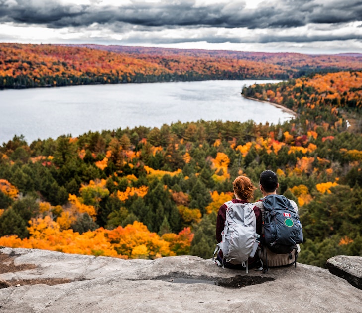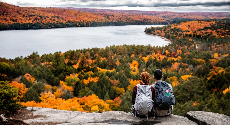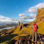
Lost cities, active volcanoes, stunning coasts: this is not an adventure movie, it's your next great hike.
We've asked some of Lonely Planet’s seasoned hikers to recount their most thrilling experiences on foot in the Americas, whether trekking in Chile or reaching the heights of Alaska.
Lonely Planet’s Epic Hikes of the Americas celebrates the American continents as a veritable hiker’s adventure playground. The new guidebook features the vast variety of terrain, climate and landscape that can be found in such a compact area, not to mention the fascinating cultures, histories and people you encounter along the way.
Here are some highlights from the book; a few hikes that will inspire you to reach for your boots and strike out somewhere new.
Explore volcanoes on these epic hikes
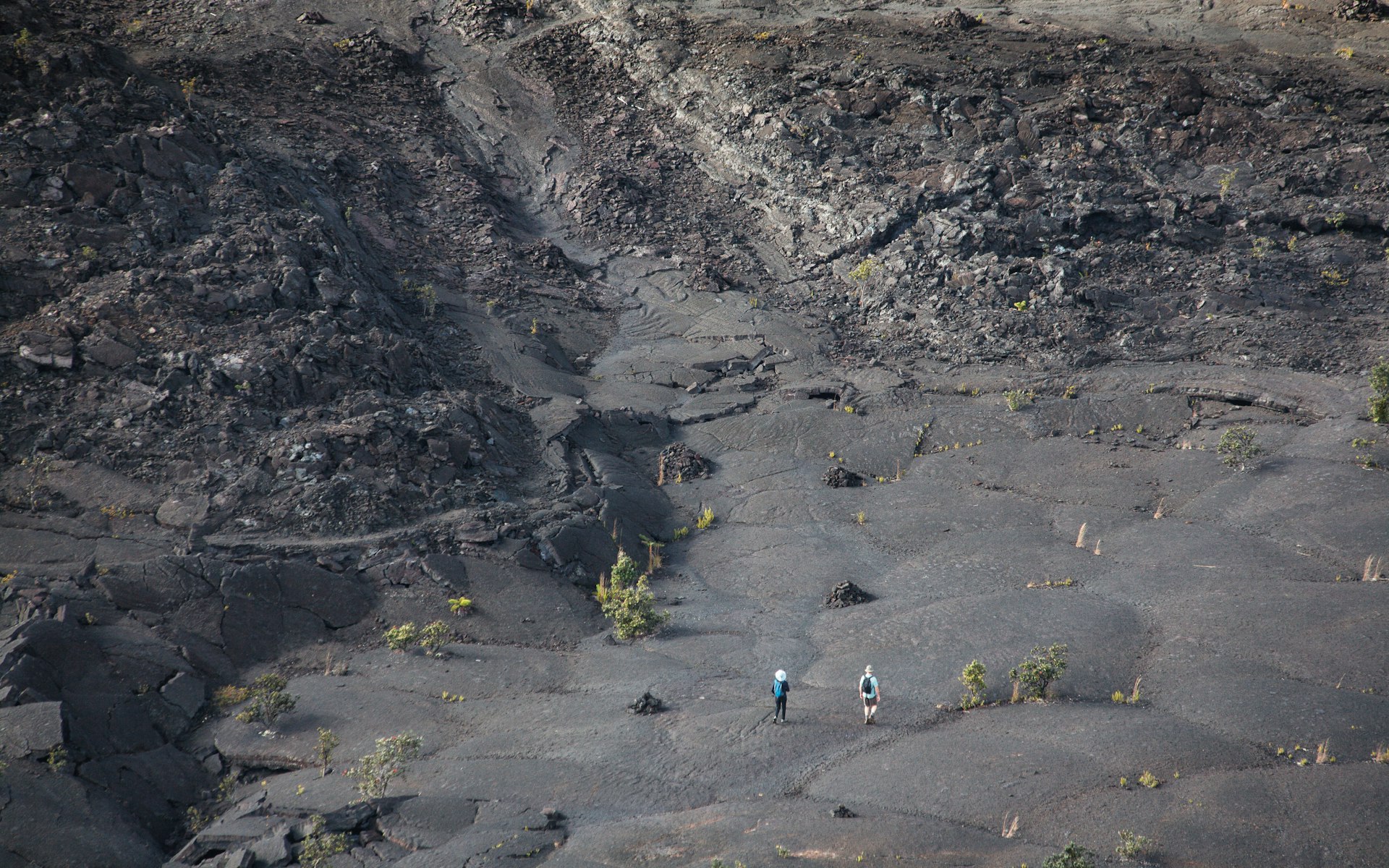
Devastation Trail, Hawai‘i
Start/Finish: Devastation Trail parking lot
Distance: 1 mile (1.6km)
Duration: 1 to 2 hours
This short but impactful hike in Hawai‘i Volcanoes National Park gets you up close and personal with the spectacular eruption of Kīlauea Iki. In 1959, this 400ft (122m) crater regularly spewed molten lava nearly 2000ft (610m) into the sky, in the process forming a new cinder cone almost overnight. Geologists knew that the magma was coming because in the months leading up to the eruption, thousands of earthquakes were being recorded daily. Today, interpretive signs point out notable features of the still-recovering landscape, over 60 years on. If you’re up for a longer hike, continue to the Kīlauea Iki trailhead, on nearby Crater Rim Drive, for a different view of this otherworldly place.
In Hawaiʻi Volcanoes National Park, witness the Earth's power
Timberline Trail, Oregon
Start/Finish: Timberline Lodge Distance
Distance: 38 miles (61km)
Duration: 4 to 5 days
Permits: You might need a Northwest Forest Pass to park at some trailheads; a free, self-issued wilderness permit is required for backpacking
A shorter but still challenging loop hike with several possible starting points, the Timberline Trail circles volcanic Mt Hood, just outside Portland, Oregon. The trail, built in the 1930s by the Civilian Conservation Corps, passes through a number of glacial drainages, and hikers are required to ford a number of streams along the way, with distant views of the jagged Cascade Range as a backdrop. Start from the historic Timberline Lodge and make your way clockwise through widely varying terrain, from the deep forest surrounding delightful Ramona Falls to craggy, weather-beaten peaks and alpine meadows. The total elevation change is about 9000ft (2743m).
The 25 best hikes in Oregon past mountains, waterfalls and dunes
Cinder Cone Trail, California
Start/Finish: Butte Lake
Distance: 4 miles (6.4km)
Duration: 3 hours
This dramatic trail around a volcanic cone at Lassen Volcanic National Park in northern California gives hikers the chance to explore a cinder cone up close. What’s a cinder cone? It’s not the main volcano, but rather a conical formation that forms after the eruption of a smaller vent. While this trail is most often done as a day hike, through-hikers on the Pacific Crest Trail sometimes pass by as well. An initially gentle climb takes you past the Fantastic Lava Beds and Painted Dunes before continuing up the side of cinder cone, while Mt Lassen looms large in the distance. From the top, at 6907ft (2105m), you can follow a short trail down into the crater. Shade is limited, so bring plenty of water, sunscreen and a hat.
The best of California's amazing hikes
Trace the paths of ancient glaciers on these day hikes

Basin Rim Trail, New Hampshire
Start: Wild River Campground
Finish: Rim Junction Distance
Distance: 4.7 miles (7.6km)
Duration: 4 hours
In the remote eastern reaches of White Mountain National Forest in Evans Notch, you can see how ancient glaciers once shaped the landscape along the Basin Rim Trail. A wooded path follows the gurgling Blue Brook, then up through dense hardwood forest with occasional glimpses over the vast tree-covered valley. At the top, you’ll reach a cliff-lined overlook with impressive views over a glacial cirque, a bowl-shaped ravine that was carved by glaciers during the last Ice Age. From here you can retrace your steps or continue another 1.5 miles (2.4km) to Basin Pond. The small waterway lies at the bottom of the east-facing cirque, and its remarkably peaceful setting belies the geological drama at play when ice and snow shaped the surrounding landscape during the Illinoian Stage some 130,000 years ago.
New England's best hikes can be enjoyed during the winter
Old Speck Mountain Trail, Maine
Start/Finish: Rte 26
Distance: 7.3 miles (11.7km)
Duration: 5 hours
You won’t have to look very hard to see evidence of the last glaciation along Old Speck Mountain Trail, an uphill stretch of the Appalachian Trail tucked away in Grafton Notch State Park. You’ll find erratic boulders (rocks left behind when the glaciers melted), scoured bedrock and even a tarn (a pond born of a glacier-formed depression). The most vivid example of Ice Age potency, however, is the glacier-carved valley of Grafton Notch. One of the trail’s highlights is the ascent to the Eyebrow Cliffs, which have an 800ft (244m) vertical drop and were likely formed by the freezing of meltwater in rock fissures, leading to the sheering off of huge chunks of bedrock. From there, you’ll have magnificent views looking east along the Bear River Valley, its dramatic U shape caused by erosion of the continental ice sheet.
10 breathtaking hikes in Maine
Umatilla Rock Trail, Washington
Start/Finish: Sun Lakes-Dry Falls State Park
Distance: 2.7 miles (4.3km)
Duration: 1 hour
In the parched scrubland of eastern Washington state, you’ll find clues from a little-known but powerful geological event. Some 15,000 years ago an ice dam burst and the prehistoric Lake Missoula sent Ice Age floodwaters tearing westward. The flood created a spectacular 50-mile (80km) chasm known as the Grand Coulee, then shot over a cliff-face creating a waterfall that was four times the size of Niagara Falls. Today, this once flooded landscape looks something like a desert oasis, with small lakes and wildlife, and the cliffs (Dry Falls) where a mighty waterfall roared are now parched and barren. The path follows the ancient river bed, passing beneath Umatilla Rock, a soaring rock formation downstream of Dry Falls, as well as huge basalt pillars, scattered by the powerful floods like toy blocks.
Walking in Washington: 12 beautiful hikes in The Evergreen State
Discover the lost cities of the Americas by foot
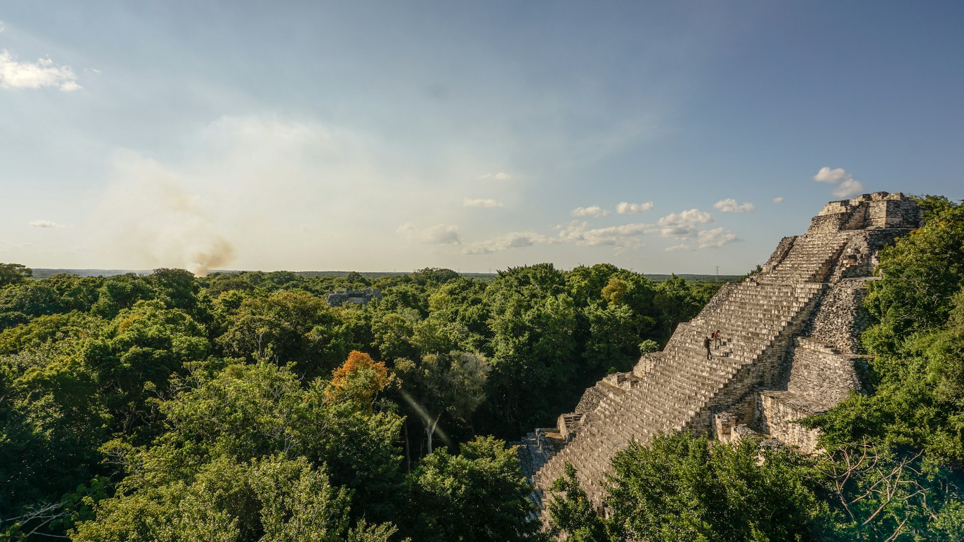
Calakmul, Mexico
Start/Finish: The parking lot at the entrance
Distance: 3 miles (5km)
Duration: 3 hours
The Mayan sites of Mexico’s Yucatán peninsula are often busy with sightseers but if you travel south through the neighboring state of Campeche and towards the Guatemala border you’ll reach Calakmul, an extraordinary Unesco-recognized archaeological site lying at the heart of the vast, untrammeled Reserva de la Biosfera Calakmul. Few people venture here so you can explore this important city, once home to the Kaan Mayan dynasty until around the 10th century, in relative peace. The ruins are surrounded by rain forest and a seemingly endless canopy of vegetation. You might glimpse ocellated turkeys, parrots, toucans and more – around 350 bird species reside or fly through here. You’ll no doubt see or hear spider and howler monkeys, too. A 5km hike loops around some of the key ruins, including the Gran Acrópolis and the Plaza del Jaguar.
The best national parks in Mexico
Camino del Inca, Ecuador
Start: The village of Achupallas
Finish: Ingapirca
Distance: 25 miles (40km)
Duration: 3 days
You can visit Ecuador’s most impressive archaeological site by vehicle, but it’s far more rewarding to hike the original Inca royal road that once linked Cuzco with Tomebamba (present-day Cuenca) and Quito. The three-day trek takes you up through the paramó (high-altitude grasslands), past mirror-like lagoons and alongside sparkling mountain rivers. With views of chiseled Andean peaks, you’ll reach altitudes of 13,780ft (4200m) – among the highest points on the royal road in the entire Inca Empire. You’ll also see other ruins before reaching the magnificent site of Ingapirca. The stone complex was once used as a fortress and storehouse (complete with an underground aqueduct) and contains an impressive temple once used for ceremonies and solar observation that was flawlessly built without mortar in the Inca manner.
Ecuador's best national parks are wild wonderlands
The Pueblo Alto Loop, New Mexico
Start/Finish: Pueblo del Arroyo Trailhead, accessible from Albuquerque
Distance: 5 miles (8km)
Duration: 2 hours
New Mexico’s remote Chaco Canyon is home to the most extensive collection of pueblos in the American Southwest. Built between the 9th and 13th centuries, they were among the largest buildings in North America until well into the 19th century. They’re now preserved under the desert sun in one of Unesco’s most sorely underappreciated World Heritage Sites. The Pueblo Alto Loop through Chaco Culture National Historical Park offers the perfect introduction to the Chaco world. Climb steps hewn into rock to the mesa above to take in panoramic views of Pueblo Bonito and other Chacoan buildings visible from the canyon rim. Then visit the trail’s namesake Pueblo Alto, an 89-room ‘great house’ that was probably used for ceremonial rituals. Complete the circuit by tramping through the rust-red dirt and descending back into the canyon below where more great houses await.
How to take a perfect spring break road trip through New Mexico
The best paths are ones that lead to good food: hikes for foodies
Gatineau Park, Québec
Start/Finish: Gatineau Park Distance
Distance: 2.8 miles (4.5km)
Duration: 90 minutes
In Gatineau Park just outside Ottawa, pair a hike through the forests and along the lakeshores with a stop for afternoon tea at the Mackenzie King Estate, the country home that once belonged to former prime minister William Lyon Mackenzie King. In office for nearly 22 years between the 1920s and 1940s, King was the longest-serving prime minister in Canadian history. After he bequeathed his 570-acre (231-hectare) property to the government in 1950, it was incorporated into Gatineau Park. Follow in King’s footsteps along the Waterfall and Lauriault trails, a 2.8-mile (4.5km) loop through the forest, which passes Mulvihill Lake and Lauriault Falls. A short detour takes you to King’s former home and gardens, which now house a tearoom.
Canada's newest hiking trail is a slow-travel adventure on Prince Edward Island
Prince Edward County, Ontario
Start: Station Rd, Hillier
Finish: West St, Wellington
Distance: 6 miles (10km)
Duration: 2 to 5 hours
Hiking Ontario’s Millennium Trail, a multi-use rail-trail through the winemaking region east of Toronto, includes plenty of stops at farm stands, cider makers and wineries. The entire Prince Edward County trail is 29 miles (46km), with the westernmost trailhead at Fort Kente Rd, near County Rd 64 in Carrying Place; the easternmost trailhead is north of Picton where Highway 49 meets White Chapel Rd. One option for a roughly six-mile (10km) day hike, with delicious stopping points en route, would start in Hillier and follow the trail into Wellington, where, if you haven’t eaten and drunk your fill as you walked, you can choose from a variety of restaurants, cafes, craft breweries and wineries.
Canada's 12 best natural wonders
Charlevoix, Québec
Start: Charlevoix Tourist Information Office
Finish: Parc du Gouffre, Baie- Saint-Paul
Distance: 7.5 miles (12km)
Duration: 3 hours
The Charlevoix region, an hour’s drive north of Québec City, is home to the Route des Saveurs, a network of cheesemakers, craft brewers, cideries, bakeries and other food and drink purveyors. You might sample wine made from tomatoes, try vodka distilled from whey or dig into an emu pizza or a plate of nuns’ farts (a sweet pastry known in French as pets de soeurs). A number of hiking trails crisscross the region, including the De La Baie route, a 7.5-mile (12km) trail with lookouts over Les Éboulements mountains and the St Lawrence River. End your hike in the town of Baie St Paul, where you can eat your fill at bistros, bakeries and other culinary stops.
Explore Canada's great outdoors on these 11 hiking trails
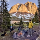
Go far and go wide: the best heli-hiking routes
Canada
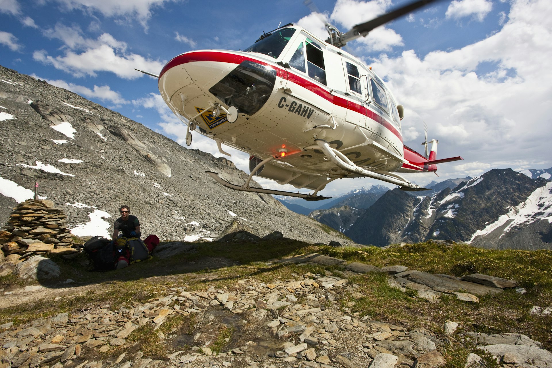
Several heli-hiking operators offer trips in British Columbia, Canada’s westernmost province. In addition to the Bugaboos trip, Canadian Mountain Holidays (CMH) runs heli-hiking adventures in two other BC destinations. Multiday trips based at its 26-room Bobbie Burns Lodge, north of Bugaboo Provincial Park, give guests the option to trek near the Conrad Glacier or tackle North America’s longest via ferrata. The newest CMH trip, from the 28-room Cariboos Lodge, takes hikers into the more remote Cariboo Mountains, west of Jasper National Park. If you don’t want to commit to a multiday heli-hiking trip, try out the sport in Whistler, a two-hour drive from Vancouver. Though this mountain community is best known for its skiing and snowboarding, it’s a year-round destination for outdoor adventures, including Blackcomb Helicopters’ half and full-day heli-hiking excursions. For more heli-hiking options, contact Glacier Helicopters or Heli Canada Adventures, both based in the town of Revelstoke, in eastern BC’s Selkirk and Monashee mountains.
Chile
While the Chilean Andes have become a center for winter heli-skiing, heli-hiking in this South American adventure destination is still in its infancy. But if the idea of heli-hiking in the world’s longest mountain range makes your heart beat faster, here are a couple of operators in Chile who organize helicopter-based hiking experiences. Lodge Andino el Ingenio, a small adventure lodge 40 miles (65km) southeast of Santiago, offers guests an optional day of heli-hiking. A 15-minute flight takes you into the Piuquenes Valley, where you’ll hike up for views of turquoise lakes and the towering Andes. Located in the Andes, 95 miles (150km) southeast of Chile’s capital, between Río Los Cipreses National Reserve and the Argentine border, NOI Puma Lodge enables its guests to heli-hike into the nearby mountains. These day treks reward with vistas across valleys, glaciers and snow-topped volcanoes.
Chile's best hikes and treks through extraordinary landscapes
Alaska
America’s largest state has some spectacularly remote areas that are nearly impossible to access on your own. From mid-May to mid-September, Temsco runs helicopter tours to the edge of Denali National Park. A 15-minute flight whisks you up to a lofty ridgeline overlooking the undulating peaks of the Alaska Range, with views of Denali (at 20,310ft/6190m, the highest peak in North America) on clear days. From there, you’ll take a three-hour hike led by a naturalist guide that gives insight into the surrounding plant and animal life. With luck, you may spy moose, curly-horned Dall sheep or even bears. Temsco also runs an excursion above the rolling tundra and up to the Yanert Glacier for a brief walk on the ice. For a longer glacier experience, book a trip out of Seward with Exit Glacier Guides, which take you by helicopter to a remote glaciated valley for a two-hour hike across Godwin Glacier (crampons and other gear included).
Find your footing in the Last Frontier with these top hikes in Alaska
Non-stop awe on the best coastline hikes of the Americas

Kalalau Trail: Kaua‘i, Hawai‘i
Start/Finish: Ke’e Beach
Distance: 22 miles (35km) round trip (6 miles/9km) and Kalalau (11 miles/18km) allow you to break the journey
Permits: camping.ehawaii.gov/camping
Duration: 3 to 5 days
One of the world’s great coastal walks, this exquisitely beautiful trail along Kaua‘i’s Na Pali Coast epitomizes the rare beauty of the Hawai‘ian Islands. The path threads its way between patches of lush tropical jungle, mountains streaked with waterfalls and idyllic coves backed by deeply fluted, colorful pali (cliffs). The juxtaposition of limpid turquoise seas against the brilliant greens and oranges of the shoreline creates a dazzling scenic effect, but walkers should not be lulled into complacency by the trail’s beauty or relatively short length. This is a rugged, physically challenging hike with substantial elevation gain and loss, best undertaken by people in excellent physical condition.
The 10 best hikes in Hawaii serve up stunning island views
Fairy Head Loop Trail: Maine
Start/Finish: Cutler Bold Coast trailhead, Hwy 191
Distance: 10.4 miles (16.7km)
Duration: 7 hours
Acadia National Park in Down East Maine is justly famous for its dramatic walks that follow shoreline cliffs above the crashing waves. Two hours’ drive northeast of Mt Desert Island, however, you can find equally majestic scenery without the heavy crowds clogging the trails. Part of the little-known Cutler Coast Public Reserved Land, the Fairy Head Loop Trail takes you through lush cedar swamp and maritime spruce-fir forest thick with moss and ferns, past blueberry barrens and across jagged headlands overlooking hidden coves and rocky beaches. The windswept views from seaside promontories are mesmerizing. As the trail turns inland, you’ll swish your way through open meadows, walk wooden planks over bogs, and have the chance to spy wildlife in a beaver pond.
10 breathtaking hikes in Maine
Superior Hiking Trail: Minnesota
Start: Jay Cooke State Park, Minnesota
Finish: Minnesota/Ontario border
Distance: 310 miles (499km)
Duration: 2 to 4 weeks
Not all coastal hikes follow the ocean. As any North American geography student can tell you, Lake Superior is one of the world’s largest bodies of freshwater, so it’s only fitting that it has its own trail, a 310-mile (499km) monster that roughly parallels the lake’s Minnesota shoreline from the Wisconsin border to Canada. Skirting clifftops and ridgelines above the lake for most of its length, the trail crosses through seven state parks and offers nearly 100 fee-free campsites for hikers. Much of the route is heavily forested with northern species such as birches, aspens, fir, cedar and pine, interspersed with stream and river crossings and occasional forays down to lake level to take in scenic attractions like the century-old Split Rock Lighthouse.