8 of the best hikes in Oregon
Apr 22, 2024
7 MIN READ

Writer
Get out and explore the Beaver State with this guide to Oregon's best hiking routes © Francesco Vaninetti Photo / Getty Images

Writer
Lonely Planet may earn a commission from affiliate links on our site. All recommendations and reviews reflect our own independent opinions.
Oregon’s wild spaces are a hiker’s dream.
You can spend a lifetime wandering a world of forests, waterfalls, mountaintops, beaches and high desert canyons. Even more important than this rich diversity of landscapes, Oregon’s trails celebrate the rich diversity of hikers. From adrenaline-fueled climbs in Crater Lake National Park to a wheelchair-accessible promenade along the Pacific Ocean, everyone is invited to experience the great outdoors in the Beaver State.
Are you ready to go exploring? The best hiking trails in Oregon are calling.
1. Trail of Ten Falls
Best hike for waterfalls 8 mile-loop, moderate, 3. 5 hours
Expect to see more than 10 cascades on the Trail of Ten Falls, which takes its name from the significant waterfalls along the route. Located in Silver Falls State Park, you aren’t merely hiking in the vicinity of waterfalls, you get the magical experience of passing behind four of them. This is an easy hike to segment with three different trailheads traveling down the canyon to commence at the top of a different 100ft waterfall. The North Canyon Day-Use Area was renovated in 2023 to include a ½ mile wheelchair-accessible trail overlooking North Falls.
Expert tip: This is one of the most popular trails in Oregon, and it gets crowded on weekends. Arrive first thing in the morning for the best experience. The Trail of Ten Falls is often wet. Sturdy shoes with good traction are a must.
Ready to visit Oregon? Check out our top things to know before you go
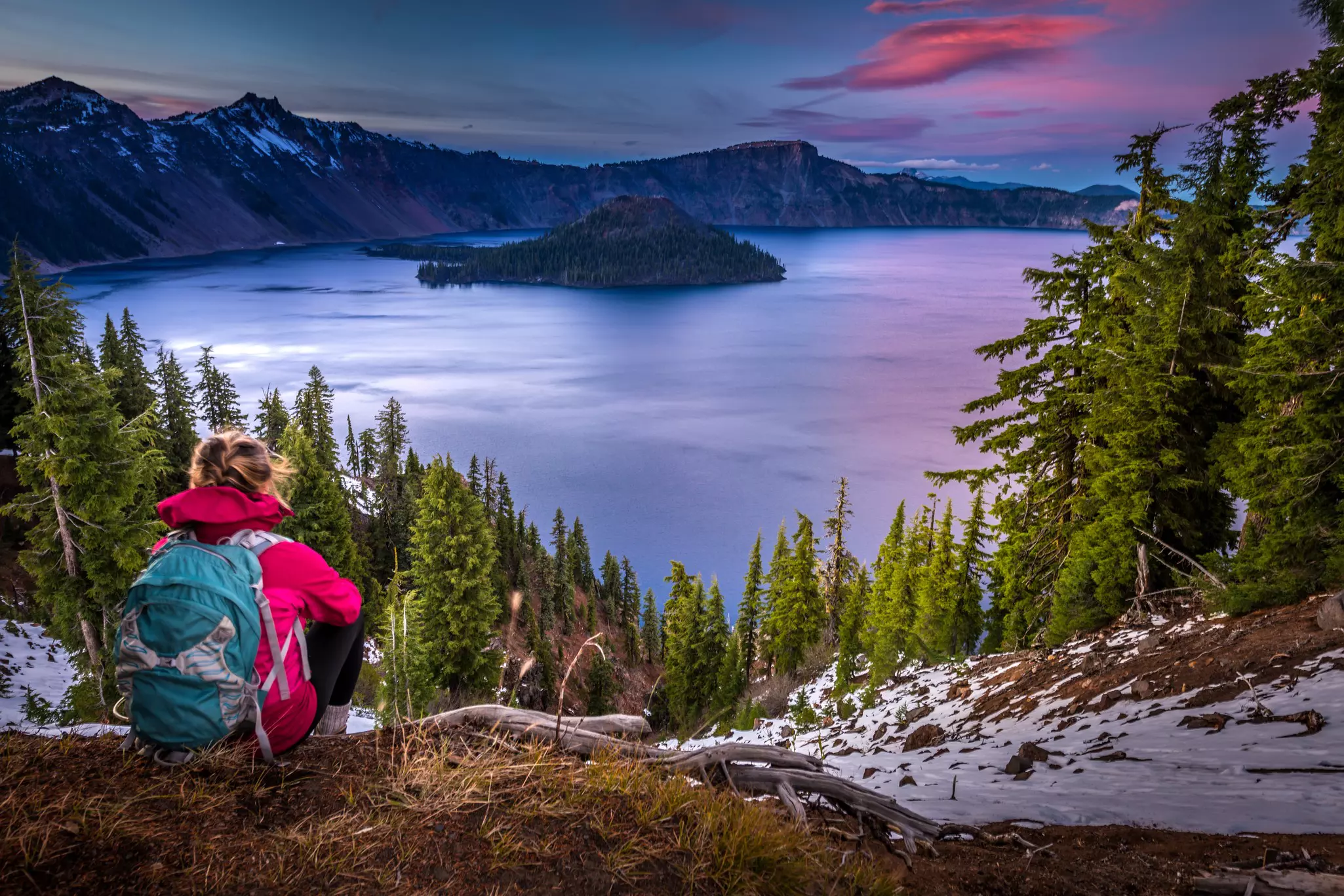
2. Garfield Peak
Best national park hike 3. 5 miles out-and-back, moderate/difficult, 2. 5 hours
You’ll find over 90 miles of hiking trails and North America’s deepest, bluest lake at Crater Lake National Park. Garfield Peak trail starts at the century-old Crater Lake Lodge. The terrain is generally smooth and non-technical, but extremely steep, with elevation gains of more than 1000ft. The views are worth it. The trail was designed to blend into its surroundings, ensuring the lake takes center stage. The higher you climb, the bluer it appears. When you reach the top, you’re rewarded with panoramic views of the lake, Wizard Island, Mt Mazama and Phantom Ship.
Local tip: Crater Lake National Park receives a great deal of snow. Be sure to check the NPS website for road closures and updated weather information if you’re visiting outside of summer.
3. Tom McCall Waterfront Park Trail
Best urban hike 1. 5 miles end-to-end, easy, ½ hour
Tom McCall Waterfront Park is the beating heart of Portland. The park hugs the Willamette River, offering views of the city skyline, bridges, and ships rolling by. Tom McCall Waterfront Park’s paved, wheelchair-accessible trail winds along the river, leading past several points of interest including the Japanese American Historical Plaza, the Oregon Maritime Museum and the Bill Naito Legacy Fountain (complete with a splash pad for the youngsters). The park is also home to some of Portland’s most iconic events including the Portland Pride Waterfront Festival, the Portland Saturday Market and the Waterfront Blues Festival.
Local tip: Old Town Chinatown and the Pearl District are within walking distance to Tom McCall Waterfront Park so allow extra time to explore the surrounding area when you finish your stroll.
Love Portland? Here are the other best places to visit in Oregon
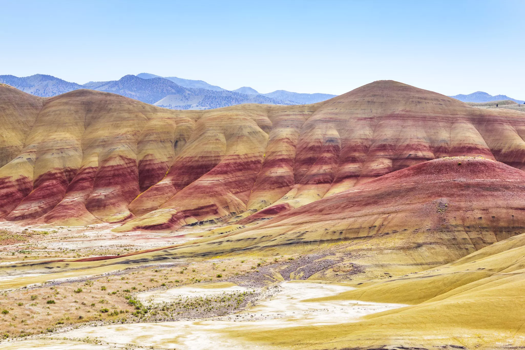
4. Blue Basin Loop Hike
Best hike for geology buffs 4 mile-loop, moderate, 2. 5 hours
Located in the Sheep Rock Unit of John Day Fossil Beds National Monument, the Blue Basin Loop hike is a kingdom of otherworldly rock formations layered with pastel green, blue and tan deposited by volcanic eruptions over 30 million years ago. Archaeological evidence reveals that this semi-arid desert landscape was once a lush, subtropical paradise with crocodiles, rhinoceros and miniature three-toed horses. It’s worth slowing down for the fascinating fossil casts and interpretive signage you’ll see along the way. The trail is steep in sections with an elevation gain of 760ft. Breathtaking vistas of the colorful canyons and John Day River valley await at the top. This area gets extremely hot in summer, so bring plenty of water.
5. Elk Mountain to King Moutain Loop
Best hike for a challenge 10 mile-loop, challenging, 6. 5 hours
The Elk Mountain–King Mountain Loop is one of the most challenging hikes in Oregon with elevation gains of nearly 4000ft. The reward is two summits separated by the beautiful Tillamook Forest. At the top of each mountain, you’ll soak in spectacular views of the lush Tillamook Mountain Range. Sturdy shoes are a must as you’ll encounter loose rock. This is a steep hike so you may have to use your hands to climb some sections.
Local tip: Be aware that with elevations this high, you may encounter snow in winter, which can lead to slippery, treacherous conditions. This hike is generally safer and more enjoyable from late spring to early fall.
6. Pacific Crest Trail (Oregon)
Best thru-hike for camping and backcountry experiences 430 miles end-to-end, challenging, 3 to 4 weeks
If you’ve read Cheryl Strayed’s memoir, Wild (or seen the 2014-movie starring Reese Witherspoon), you already know that the Pacific Crest Trail is challenging. The entire trail is 2650 miles, traveling from Canada to Mexico. The Oregon segment is a 430-mile stretch from the Siskiyou Forest in Southern Oregon to the Columbia Gorge (or vice versa). The trail takes you on a bucket list journey through highlights like Crater Lake National Park and wilderness areas with hidden lakes and meadows few are fortunate enough to see. There are long stretches of forest and it’s possible to hike for days without seeing another human being.
Local tip: It’s legal to camp just about anywhere along the Pacific Crest Trail, but there are a few designated camp spots in the backcountry. Some sections require permits.
7. Seaside Promenade
Best hike for accessibility 1. 5 miles end-to-end, easy, ½ hour
Affectionately referred to as, “the Prom,” the Seaside Promenade is one of the most beloved stops on the Oregon coast. Built in 1920, this 15ft-wide walkway travels between shops, restaurants and homes on one side, and the beach and Pacific Ocean on the other. The Prom is paved and wheelchair accessible. In addition, Seaside offers complimentary wide-tire beach wheelchair rentals to help disabled visitors navigate the sand (reservations are recommended). Highlights along the Prom include the Seaside Aquarium and the Lewis and Clark Salt Works, a historic rock cairn believed to have been used by the Corps of Discovery in the early 1800s.
Local tip: Seaside is a great destination for families. In addition to the beach and the Prom, you’ll find kid-pleasing attractions like a carousel, an old-fashioned arcade and plenty of sweet shops.
8. Multnomah Falls Trail
Best for scenery 2. 3 miles out-and-back, moderate, 1. 5 hours
At 620ft, Multnomah Falls is Oregon’s tallest cascade. Its namesake trail takes you from the base to the top of the falls, with spectacular viewing opportunities of the mighty two-tiered falls thundering down the cliffs. The trail is paved, but with steep, narrow switchbacks as it winds towards the top. The lower falls area is wheelchair accessible. Multnomah Falls is one of the most popular attractions in the Pacific, so arrive early in the morning to avoid the crowds.
Expert tip: Timed entry tickets are required for parking from 9am to 6pm from the end of May to the beginning of September. There is no fee if you bike, hike or shuttle in.