Jun 5, 202513 min read
See Scotland's remote Shetland Islands on this 4-day itineraryJun 5, 2025
13 MIN READ

Writer
Shetland promises dramatic landscapes and rich history. Finn Beales for Lonely Planet

Writer
Lonely Planet may earn a commission from affiliate links on our site. All recommendations and reviews reflect our own independent opinions.
The northern islands of Scotland have always been a little apart from the rest of the nation, culturally as well as geographically. In the scattered Shetland Islands, people take their cultural cues from both the Scottish mainland and Scandinavia – which ruled over the islands until the 1470s.
If the Orkney Islands feel remote, Shetland can feel like another world, washed by the wind and waves of the North Atlantic, 130 miles (210km) north of the Scottish mainland. But isolation has bred a warm and welcoming culture, preserving enigmatic customs and a profusion of timeworn relics from Scotland’s ancient past.
In fact, Shetland isn’t as inaccessible as you might think, with daily flights to Sumburgh Airport on Mainland – the largest of the Shetland Islands – and daily ferries from Aberdeen to Lerwick, the islands’ pretty capital city. Thanks to North Sea oil, the islands also have better infrastructure than you might expect from such a remote and far-flung destination.
For the ultimate Scottish island adventure, grab your rainproofs and head to the edge of the map for this four-day Shetland itinerary.
Shetland is exposed to the full force of the Atlantic, so you’ll need to plan for the weather, though the Gulf Stream keeps temperatures milder than you might imagine for this northerly latitude. The best time to come is from May to September, with the driest skies and longest days for exploring from June to August.
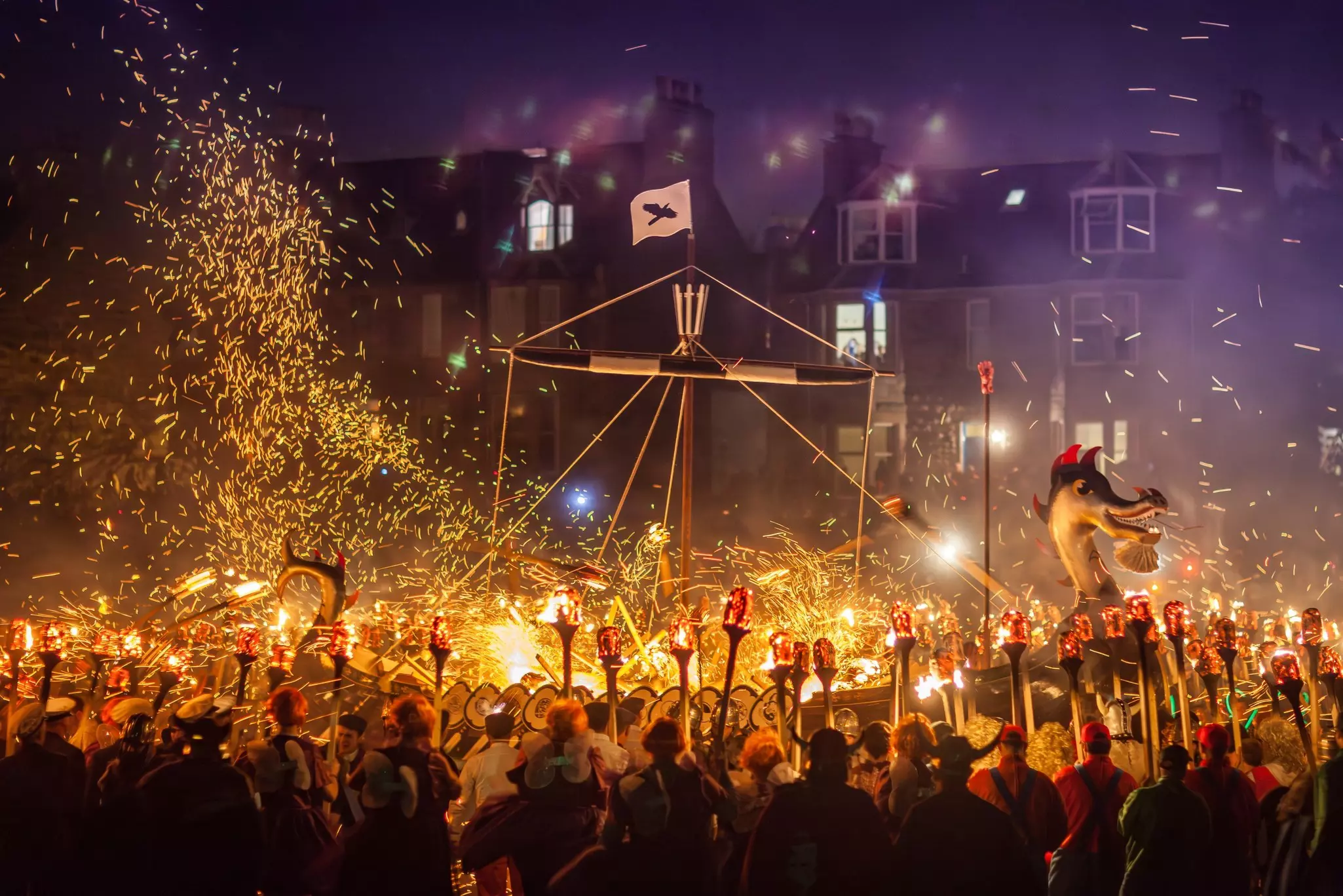
Summertime midges are less of a problem here than on the Scottish mainland, thanks to the steady winds, and crowds are rarely an issue except in peak summer at key locations such as Jarlshof, or during the Viking-inspired Up Helly Aa festival in January. Winter can see dramatic, windy conditions but little snow, and there’s a chance of spotting the Northern Lights – known locally as the “mirrie dancers.”
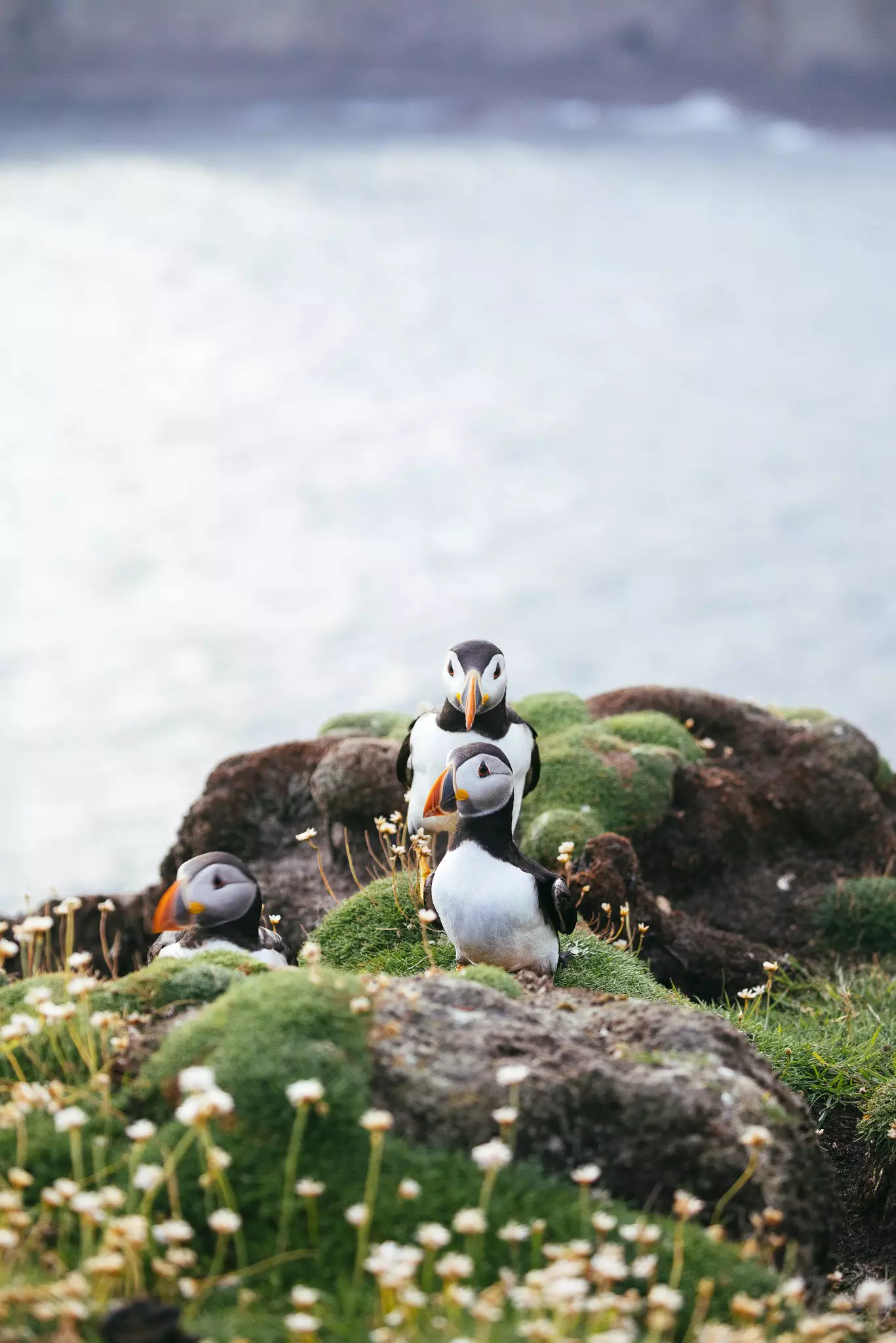
Spring and fall have their own magic, with the arrival and departure of untold thousands of migrating seabirds, including the islands’ enigmatic puffins. For uplifting walks across the islands, summer is better than the sometimes damp months of spring and fall (tours and inter-island ferries run more often too).
Getting to Shetland is easy enough, whether you come on the Loganair flight to Sumburgh or the overnight Northlink Ferries car ferry to Lerwick. If you come by boat, you can add Orkney to your itinerary, too – several times a week, the ferry stops on the first evening in Kirkwall before continuing to Shetland.
If you come without a car, you can hire one on arrival through Bolts and other local car hire companies. Having your own wheels is a much easier way to explore than relying on infrequent public buses (which become even less frequent once you leave Mainland).
While the Gulf Stream warms the Shetland Islands, temperatures don't climb much above 18ºC (64ºF) even in summer, so you’ll want some warm layers year-round. Rain can arrive at any time of year, so bring a windproof layer and rainproofs – a better idea than trying to keep an umbrella up in this windy part of the country.
Be sure to pack sturdy, waterproof footwear and spare dry socks for walks, as well as a map and compass. If you want to bring a tent, wild camping is possible on unenclosed land across the islands, so long as you follow the Scottish Outdoor Access Code.
How to spend the day: Shetland’s busy but surprisingly attractive capital city is home to just 7500 people – a third of the islands’ population. Spilling almost into the water, Lerwick is built almost entirely of grey stone, straddling a narrow neck of land overlooking a superb natural harbor.
Devote your first day to discovering Lerwick’s charms on foot. Wander the harbor, with oil boats competing for space with ferries, cruise liners and the islands’ dwindling fishing fleet, or stroll along lively Commercial St and you’ll quickly get a feel for this welcoming city.
Start a morning walk on the waterfront at Hay’s Dock, built by the company Hay & Ogilvy in the 1820s to service their herring fishing fleet. Head south along Commercial Rd, then bear right at Harbour St and go through the arched gate into Fort Charlotte, built in 1781 during a time of war with France and Spain.
Exit at the far end and wander along atmospheric Commercial St, the bustling heart of old Lerwick, past shops, cafes and the old Market Cross, a stone pillar with a Victorian barometer. This is where the Up Helly Aa Proclamation Bill is posted, kicking off the annual celebrations in January. Nearby, the Shetland Times Bookshop is a treasure trove of books on Shetland history.
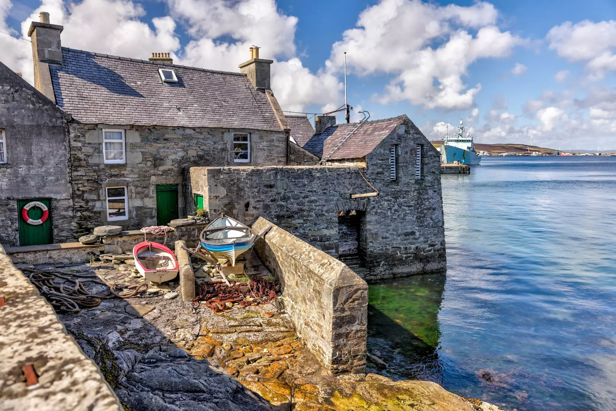
Just past the Queen’s Hotel are Bain’s Beach and The Lodberrie, a private wharf where 18th-century merchants transferred cargo to and from their ships. Continue along Twageos Rd and follow the footpath beyond the cemetery to reach the rocky headland known as The Knab.
After a short section on Breiwick Rd, follow another path (signposted Ayre of Clickimin) past Da Sletts, a rocky platform once used as a natural pier, to finish at the well-preserved remains of Clickimin Broch, an impressive Iron Age fortified tower.
Returning to the center, take a late lunch, then swot up on the history of the islands, from Iron Age broch-builders to Viking jarls (earls) at the Shetland Museum. Highlights include replicas of the St Ninian’s Island Treasure, the finest hoard of early medieval silver ever found in Scotland, dating from around 800 CE (the originals are in Edinburgh’s National Museum).
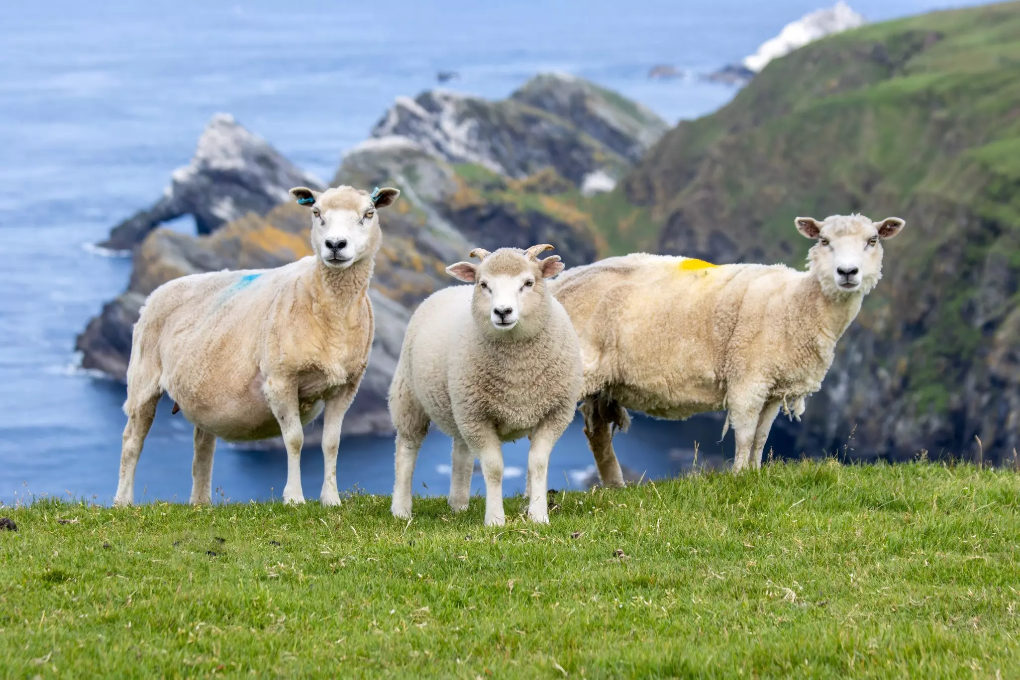
Next, take a 1.5-mile (2.4km) walk north to the 18th-century Böd of Gremista, a former fish-curing station that now houses the Shetland Textile Museum, with displays on the knitwear and textiles that take their name from the islands. If you want to buy a Shetland sweater, try Jamieson’s of Shetland or Anderson & Co – Shetland patterns fall somewhere between Highland tradition and Nordic noir.
Evening: For a fine “welcome to Shetland” dinner, take your pick from Fjarå, a Scandi-style coffee bar with superb sea views and scrumptious food menus, or No 88 Kitchen & Bar, a hip and relaxed spot with seasonal dishes championing Shetland seafood and lamb.
Explore Mainland: Shetland’s largest island is narrow but long, measuring around 60 miles (97km) at its longest point. A car is the easiest way to explore, but you can also take tours or use local buses to get around.
How to spend the day: Use your second day on the isles to delve into Shetland’s rich history at a string of historic sites in south Mainland. Start in Scalloway, the island’s original capital, where the rain-beaten remains of Scalloway Castle – built by Patrick Stewart, the tyrant Earl of Orkney, in 1600 – rise over an island-sprinkled bay.
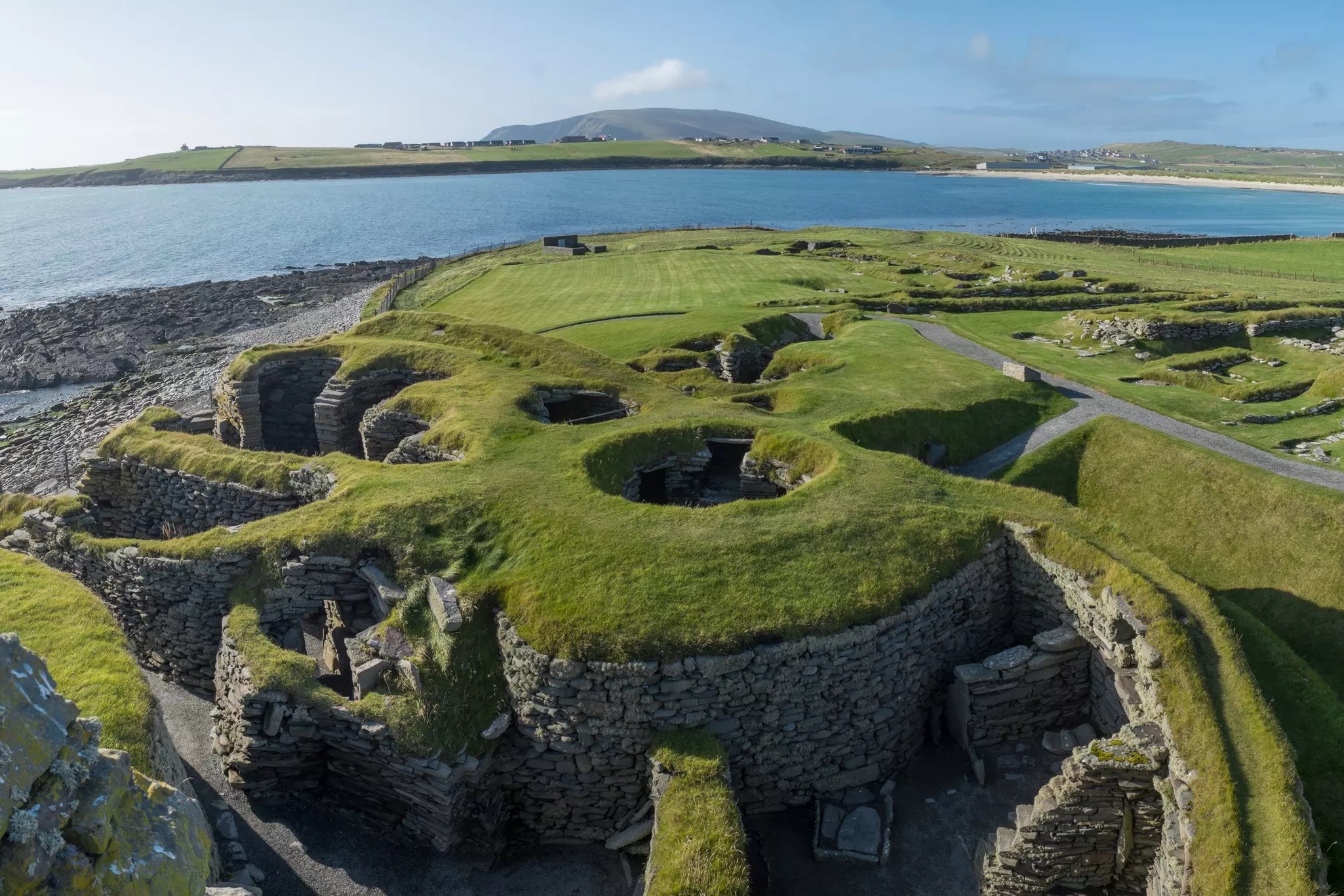
Continue around 25 miles (40km) south through green countryside to reach Sumburgh Airport, and just beyond, the wonderful ruins of Jarlshof, Scotland’s most extraordinary archaeological site, spanning more than 4000 years of continuous occupation. Pick up an audio guide and follow the numbered trail from Neolithic roundhouses through an Iron Age broch and mysterious wheel houses to Viking longhouses and medieval farmhouses.
The most recent structure is the 16th-century Old House of Sumburgh, built by Patrick Stewart; it has a cameo in Sir Walter Scott’s 19th-century novel, The Pirate, where he calls it Jarlshof, meaning “Earl’s House.” About a mile northwest is Old Scatness, another broch surrounded by the remains of an Iron Age village, which you can explore on a tour (Fridays only from May to August).
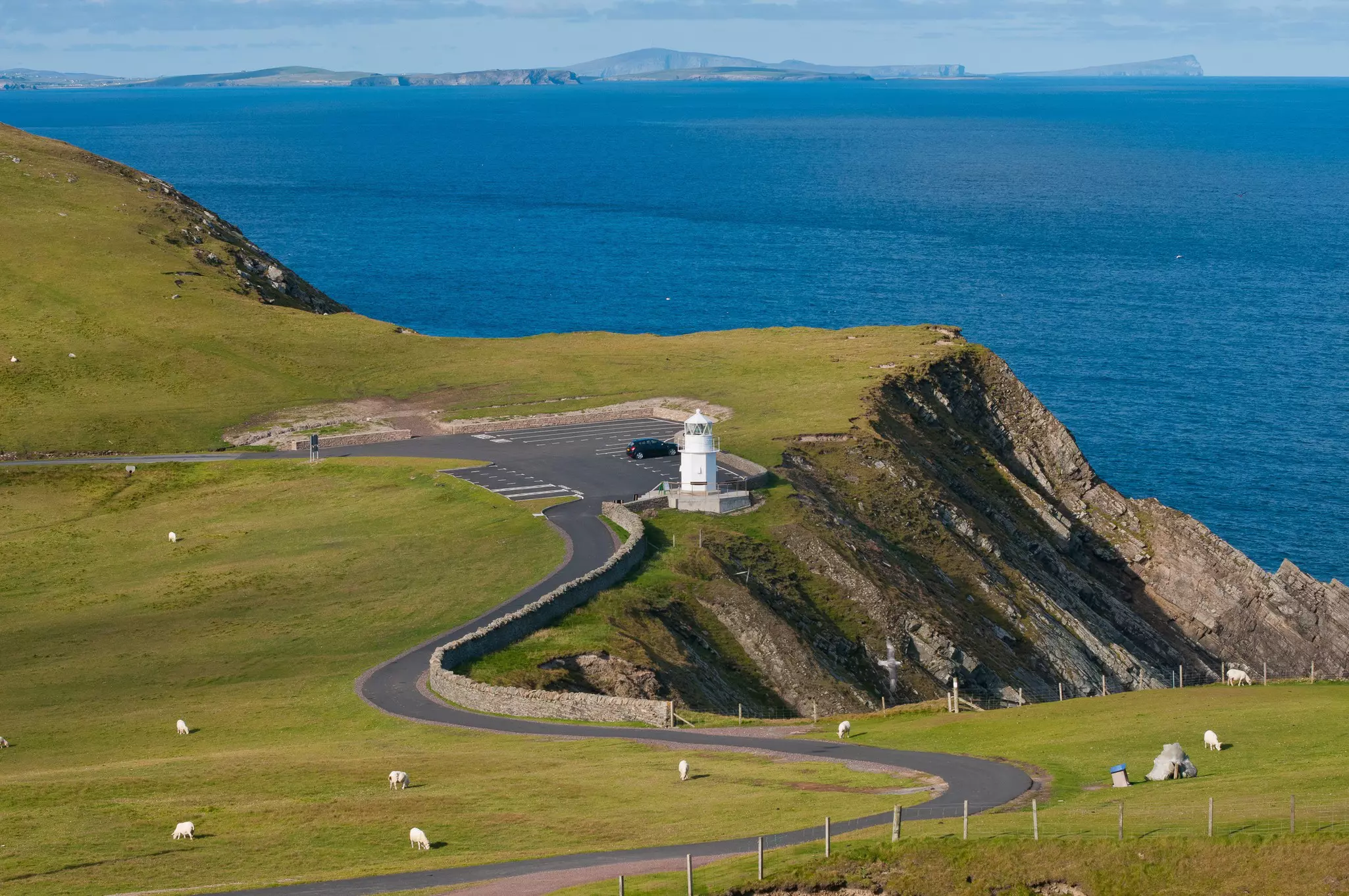
Follow the road south beyond Jarlshof to a sudden dead end at the dramatic sea cliffs of Sumburgh Head. It’s a 10-minute walk uphill from the car park to the visitor center, which tells the story of the headland’s 19th-century lighthouse and its massive foghorn. The views here are stupendous, looking west to Ness of Burgi and south to Fair Isle.
In calm weather, there’s a chance of spotting whales, and from May to August, you can look over the wall beside the hairpin bend in the road to see a steep grassy slope alive with puffins, while shags, guillemots and fulmars throng the nearby cliffs.
Next, head north to Boddam, where a minor road runs southwest to the restored and fully operational 19th-century Quendale Water Mill, the last of Shetland’s watermills. There’s a small but fascinating museum stuffed with exhibits on local history, including the story of the oil tanker Braer, which ran aground on the rocks of Garths Ness in 1993.
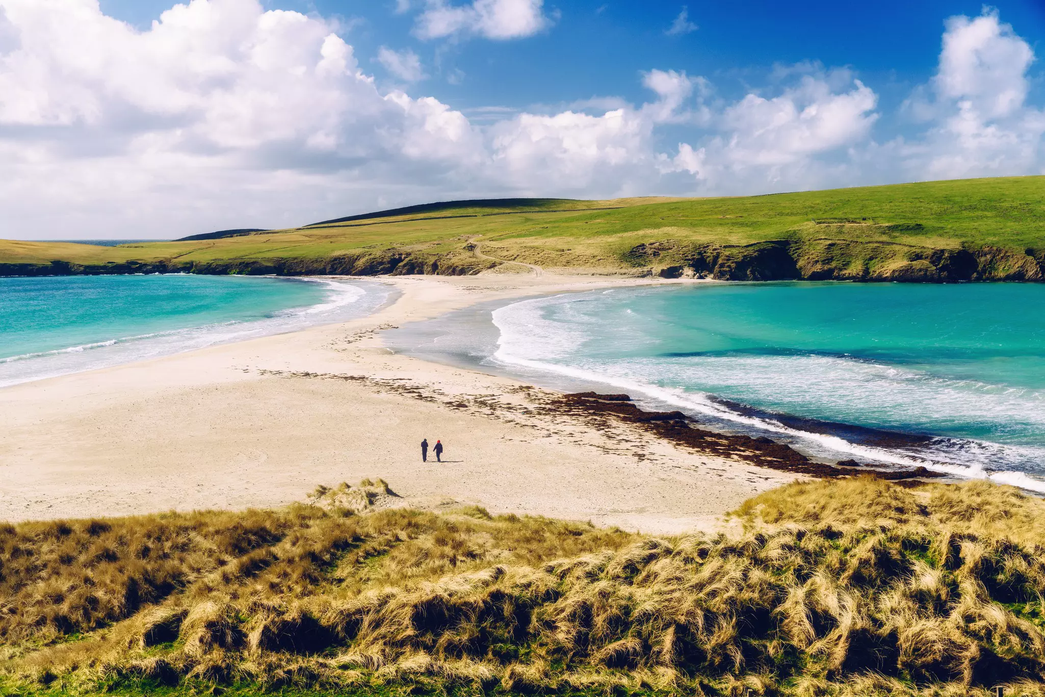
Near the village of Bigton, on the west side of Mainland, Atlantic storm waves refracting around the north and south ends of St Ninian’s Isle have created a blindingly white, hourglass-shaped sand spit, or tombolo, connecting the island to the mainland.
This is one of Shetland's most perfect beaches and you can walk across to explore the ruins of a 12th-century church, beneath which are traces of an earlier Pictish church, where the famous St Ninian’s Island Treasure was unearthed.
Evening: Returning to Lerwick for dinner, stop for a meal with a bay view at the Lerwick Hotel, or cafe-bar plates at The Dowry on Commercial St, where there’s often live music.
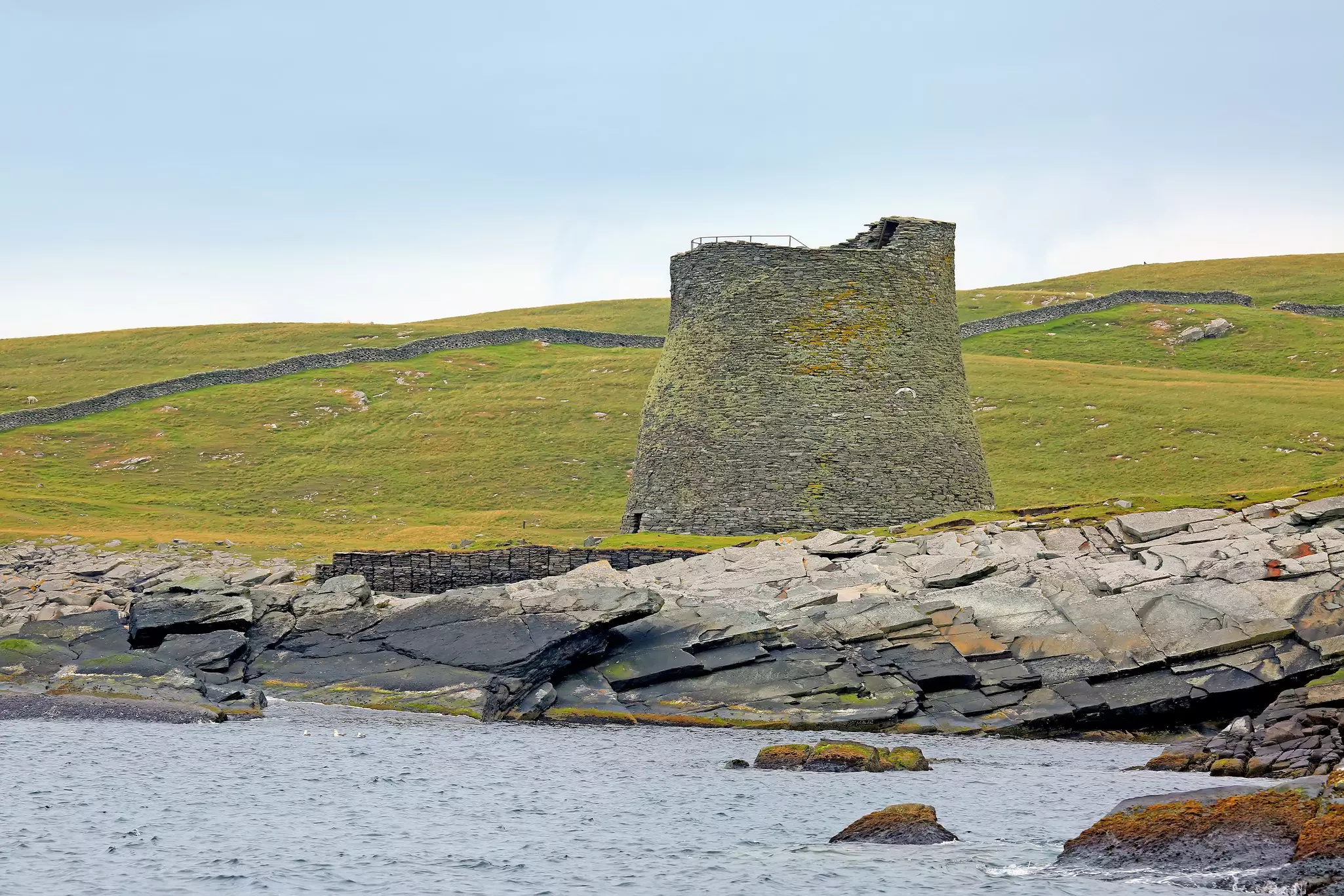
How to spend the day: On day three, you’ll have time to roam around the north and west of Mainland, but first, make one more detour south to the little island of Mousa, home to Scotland’s best-preserved Iron Age broch, still towering to almost its original height of 13m (39ft) more than 2300 years after it was built. You can climb inside the walls to take in sweeping sea views.
The island is also a nature reserve, famed for its 14,000-strong colony of storm petrels – tiny, swallow-sized seabirds that nest in the gaps between the stones of the island’s beaches, drystone dykes and broch. Get here on the Mousa Boat (daily except Saturday from April to September) from Sandsayre pier.
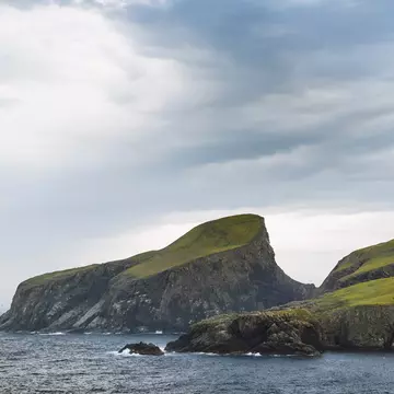
The Mousa trip will take you from late morning to mid-afternoon; afterward, scoot up to the north end of Mainland. Around six miles (10km) west of Hillswick, the road ends at the multicolored cliffs of Eshaness, the eroded flank of an ancient volcano that has been carved by the Atlantic waves into some of the most impressive and wild coastal scenery in Shetland.
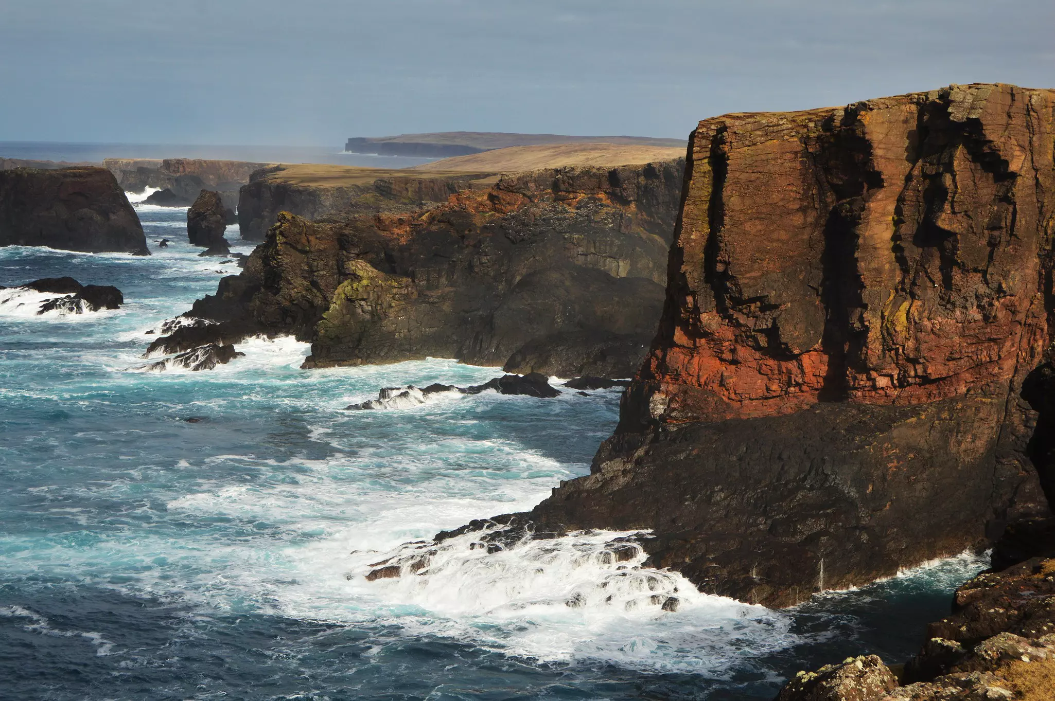
From the car park beside the lighthouse, walk along the close-cropped turf of the cliff tops to the Holes of Scraada, a tortured fissure floored by a black-sand beach. It lies well inland but is linked to the sea by an underground tunnel. The chasm was originally a cave, but the roof collapsed in 1873 when a local man rode across on his horse.
North again is the Grind o da Navir (Gate of the Borer), an impressive rock formation where the sea has carved a massive gash between two towering cliffs. The winter storms here are so fierce that huge blocks of rock have been piled high above the waterline by the force of the waves.
An alternative to Eshaness – providing the weather is clear and there are enough hours of daylight remaining – is the hike up Ronas Hill (450m/1476ft), the highest point in Shetland. The haunting, cloud-shrouded peak can be climbed from the end of the steep, narrow road to the radio mast at the top of Collafirth Hill, just beyond the turn off to Ollaberry. Take a map and compass, and allow two to three hours for the 4-mile (6.4km) round trip.
Evening: If you can get there before closing time at 7pm, the award-winning Frankie’s in Brae (on the way back to Lerwick) is the island’s favorite fish and chip shop. Otherwise, dine nearby on classic Scottish fare at Busta House, a striking white manor house originally founded in 1588.
Go to Yell and Unst: Ferries connect Mainland to the islands of Yell and Unst, and ferries and flights run to Fair Isle. It pays to book ahead if you need a space for your car on the ferry.
How to spend the day: Easily reached by ferry from Toft near the Sullom Voe oil terminal, Yell may look like a bleak expanse of bog and moor, but it’s one of the best places in Europe to spot otters. Fish, shellfish and crustaceans abound, the peaty shoreline is ideal for digging their holts (burrows), and there are plenty of freshwater streams for rinsing off the salt water.
Shetland Nature offers expert-guided otter-spotting and wildlife photography day trips; if you’d rather go it alone, the Yell information leaflet, available from the Lerwick tourist office and Shetland Museum, has a map showing the best otter-watching locations. If time is short, try the harbors at Uyea, Cullivoe, Ulsta and Gutcher.
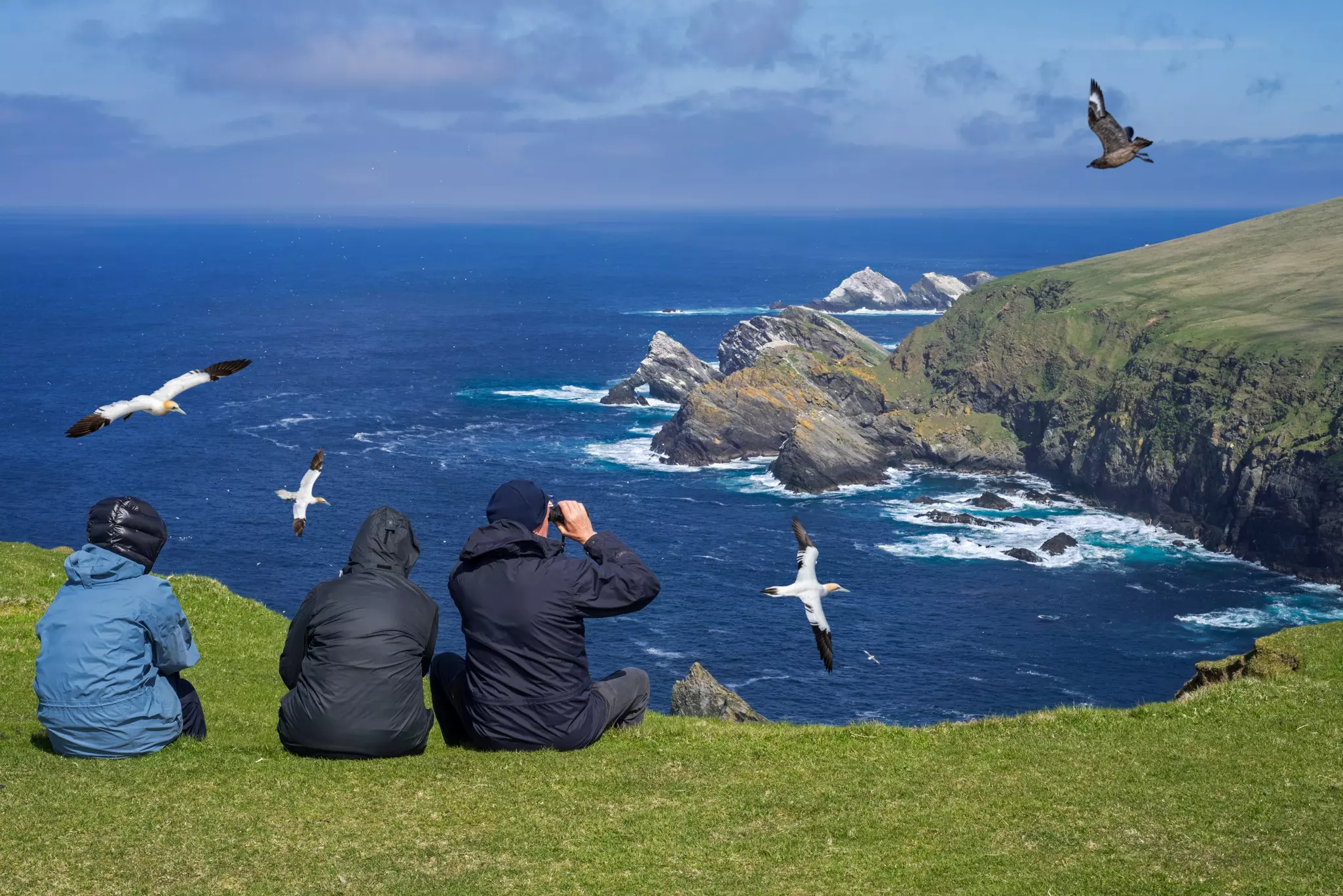
From Gutcher, you can take a second ferry to Belmont on Unst, then devote a wonderfully rewarding half day to the spectacular seabird colonies of Hermaness, at the far northern tip of the Shetland Islands. The sea cliffs here are white with nesting gannets, fulmars and guillemots, and colonies of puffins burrow in the grassy clifftops. Get here via a round-trip walk of just over 4 miles (6.5km) from the end of the road beyond Haroldswick.
It’s well worth diving into Unst’s rich Viking heritage. Archaeologists have discovered the remains of more than 60 Viking longhouses, and you can view some of these ruins at Underhoull and Lund in the south, and Hamar in the north. You can also visit a full-size re-creation of a longhouse alongside a replica Viking longship at Haroldswick.
As an alternative to Yell and Unst, consider crossing the ocean to Fair Isle – Scotland’s most remote inhabited island – 24 miles (39km) south of Mainland. The easiest way to get here and back in one day is to fly from Tingwall near Lerwick with AirTask – several days a week, you can fly out in the morning and return the same afternoon.
Lying halfway between Shetland and Orkney, Fair Isle is far removed from the bustle of Mainland life, with its own distinct rhythm, punctuated by the clack of “makkin wires” (knitting needles) and the raucous calls of thousands of wheeling seabirds. It’s known for its colorful knitwear, still produced by craft knitters such as Exclusively Fair Isle.
The island is also a paradise for birders, who form the bulk of the island’s visitors. Fair Isle is in the flight path of many migrating birds, and thousands breed here. They’re monitored by the Fair Isle Bird Observatory on the east side of the island, which can provide advice on the best birding spots.
Evening: Use the last evening – ideally a Friday or Saturday – to tap a toe to traditional Scottish music back in Lerwick. Head to the Douglas Arms, or the charmingly informal Lounge Bar, where music sessions feel like a fishing boat crew took up residence in someone’s front room.
This article was adapted from Lonely Planet’s Scottish Highlands & Islands guidebook, published in June 2025.
Explore related stories