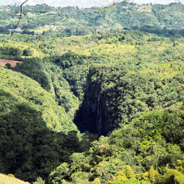
This 5000-acre forest just off Hwy 621, halfway between Arecibo and Utuado, sits amid some of the island's most rugged terrain. In the bosom of karst country, the forest’s altitude jumps between 700ft and 1400ft above sea level. The steep sides of the mogotes (precipitous limestone hills) are overrun with vines and the forest features fine tropical hardwoods, including Honduran mahogany and Asian teaks, beside huge clumps of bamboo.
The remains of the lumber roads cut by the loggers and the Civilian Conservation Corps (CCC) workers have now become trails.
The first trail you'll encounter, starting from the currently defunct visitors center, is the Visitors Center Trail, a 545yd-long stroll with three gazebos set up along the way, in the east of the park before the road reaches the DRNA office. Hwy 621 continues a few miles further into the forest to a camping, picnic and recreation area. Near this point, there is an aviary where the DRNA is working to reintroduce the Puerto Rican parrot and other endangered species. Several more trails begin here. Branching south off the access track to the aviary, the Cueva del Agua Trail is a 40-minute-return route to a cave with a small lake inside. Longest is the Río Tanama Trail, a five-hour-return route to a good swimming spot. The starting point is from the track leading to the aviary. Enquire at the DRNA office just inside the park boundary and you should be able to obtain a map and piece together a more substantial hike through this karst country.
To reach Bosque Estatal de Río Abajo from San Juan, take Hwy 22 west toward Arecibo. Turn south on Rte 10 toward Utuado. Turn west on Hwy 621 and continue to Km 4.4 and the park entrance.