Jun 27, 20267 min read
A guide to Indonesia’s Tumpak Sewu waterfallJan 10, 2022
6 MIN READ
Writer
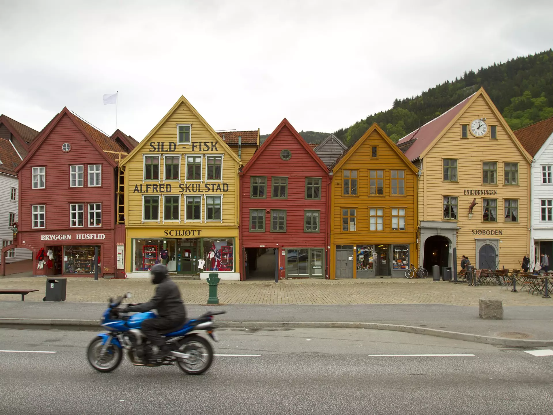
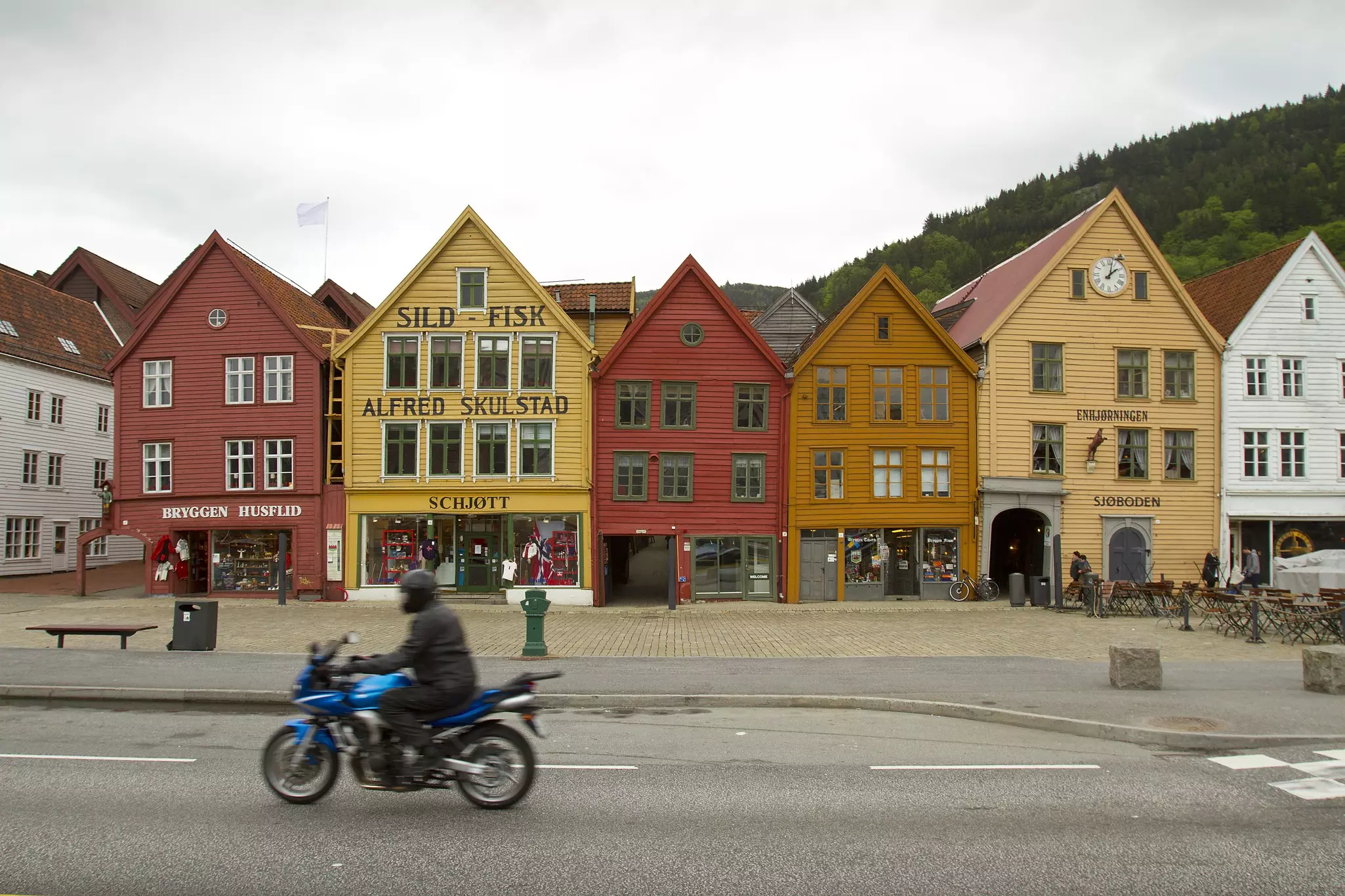
The colorful buildings of Bryggen in Bergen, on your way out to the start of the road trip © Nick Pederson / Getty Images
Writer
Lonely Planet may earn a commission from affiliate links on our site. All recommendations and reviews reflect our own independent opinions.
Norway means ‘narrow way through the straits’, rather apt, given the mighty glacial fjords that lacerate its western coast.
Admittedly there’s not much that’s spellbinding as I roll north out of Bergen. The majesty comes later; for now I’m passing the engineering workshops and other small factories serving the oil and gas industry that has made the city rich – again. The charming buildings that surround the harbor are a reminder that Bergen was a successful business centre for many centuries, going back to its days as a Hanseatic port.
I’m riding out in the wonderful, slightly watery, sunshine typical of Norway. As I follow the fjord first east and then north before turning inland again to Voss, the rugged, often vertical countryside begins to work on me, raising thoughts of Vikings, moody gods and other things quintessentially Norwegian.
Norway’s roads, bridges and tunnels are sparkling examples of their builders’ skill and tenacity, but they shrink to scratches on the mile-high cliffs if you look up a little. Whoops! Not enough attention on the road and a long frost break is trying to turn my front wheel into oncoming traffic. Norway’s main roads are excellent, but not all back roads survive the brutal winters unscathed.
I turn north at Voss on E16, before snaking my way up to Stalheimskleiva. One of the steepest roads in Northern Europe, it runs between two mighty waterfalls offers up 13 hairpin bends on its mile-long, 20-degree climb to the eponymous hotel at the top. Unsurprisingly, it took seven years to build the whole six miles (10km) of road, before it was finally completed in 1849. At the top, the view towards Gudvangen from the hotel is spectacular, with near-vertical cliffs boxing in the narrow but lush, green valley bottom.
Where to find myth and legend in Norway's wildest landscapes
Directly to the west of Stalheimskleiva, continuing along E16, lies the village of Flåm where I face a decision. Do I carry on straight ahead through the 16-mile-long (28km) Lærdal tunnel - the world's longest road tunnel and a marvel of modern engineering - or take the old road across the top? I’ve ridden through the tunnel before, so the choice is easy. I don’t regret it. Climbing up the old Bjørgavegen road, there are deep snowbanks alongside the 30 mile (48km) stretch of narrow, steep and twisting road but its surface is clear and tempts my inner boy racer. It's always wise to plan your driving routes ahead in Norway as many of the mountain passes close during the winter months, which could result in a long detour!
Once over the top and back down at sea level, I speed along Route 5, running down one of the tentacles of Sognefjord. Eventually, I cross it on a ferry and turn west along its shore, ahead of another boat that takes me across to Dragsvik and on to the E39 main road. It’s an intoxicating run north and east from here. Sticking to E39 is recommended as it always runs alongside a fjord or crossing a rocky range, populated by hairpins, smooth, long curves and regular blinks of tunnels.
Where to experience Sámi art and culture in Norway
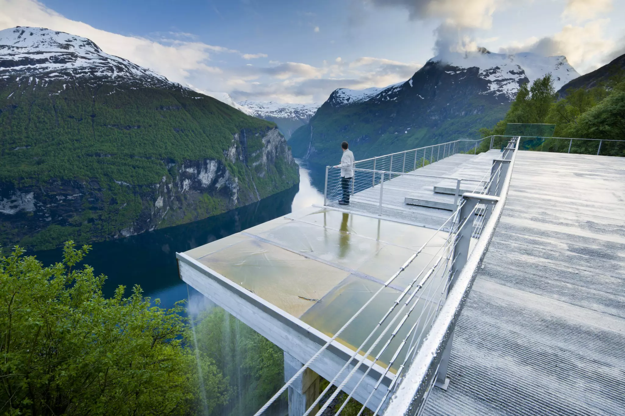
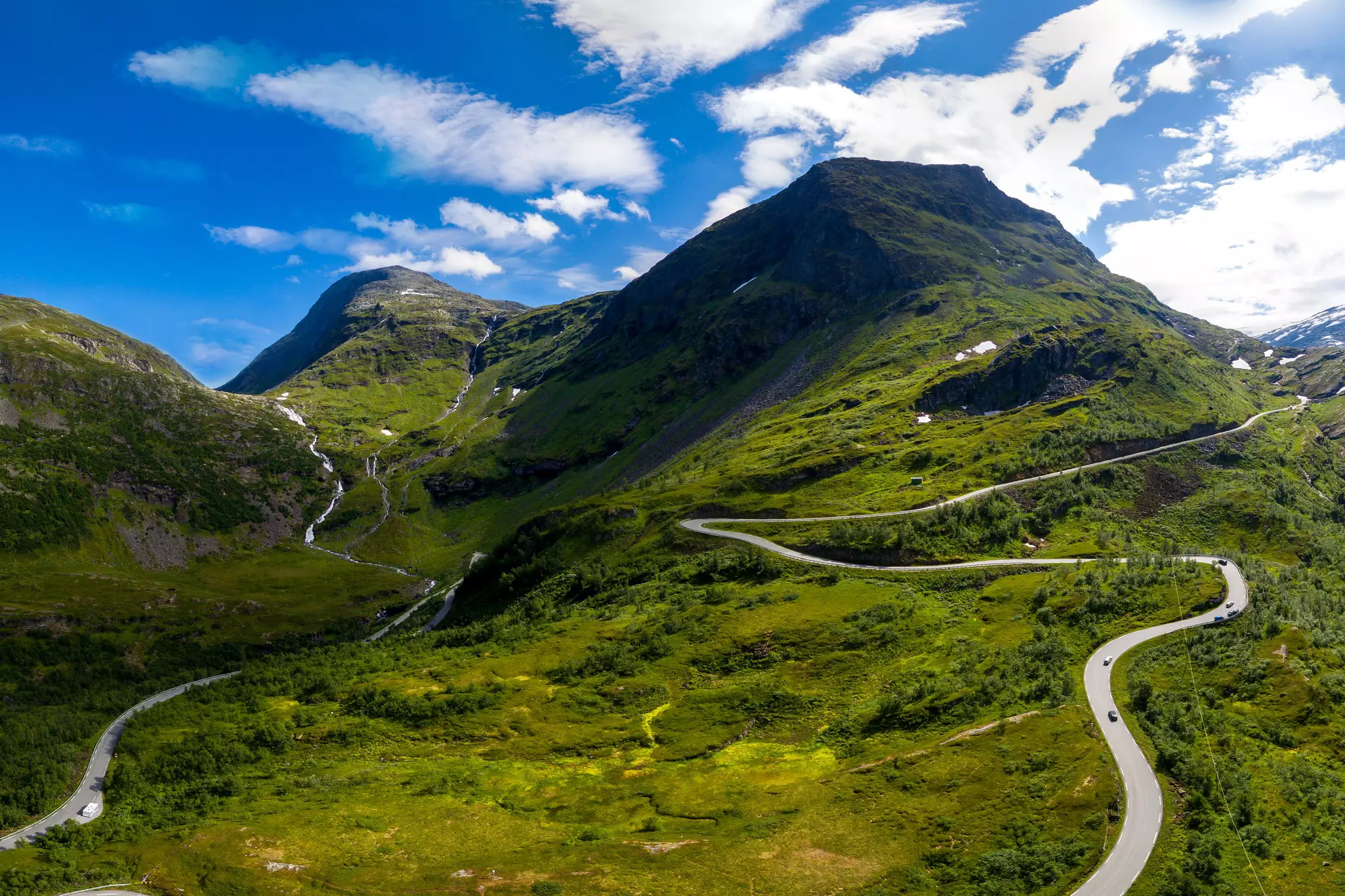
At Grotli I turn west again, and after following the waterside for a while along Route 15, I break off onto Route 63 and climb back up to the high, icy country that interrupts the fjords. The drop back down to sea level at Geiranger is a superb stretch of road, which deservedly won a prize at the 1924 World Expo in Paris. Climbing back up from Geiranger is just as impressive. Route 63 takes you to Ørnesvingen, the Eagle’s Road, which features a wonderful lookout like a long tongue of concrete at the top.
Further north on Route 63, the high valley before Trollstigen is renowned for its strawberries, and the fields stretch as far as I can see. After a quick visit to Jordbaestova, a cafe advertising the best strawberry cakes in Norway, I reach the top of the notorious Trollstigen pass, meaning Troll’s Ladder. I pull in at the car park and walk to the viewing platform. Piles of stones, balanced on one another, dot the rocks. ‘The tourists think the trolls like them, ’ says a local. ‘They don’t. Anyway, there are no such things as trolls.’ I’m not sure about that. There’s one outside the futuristic information center, with its odd looks combining humor and veiled threat.
The brochure about Trollstigen claims only 11 hairpins for the descent. That may be true in the strictest sense, but it feels like a lot more, as my bike takes me over bridges spanning white water tumbling the 762 meters to the valley floor, and along short straits with steep drops on one side and more sheer rock on the other. Then it’s a short run along E136, which runs parallel to Romsdalsfjord and up the peninsula that has Ålesund at its tip. This is a lovely town, best seen from the hill behind its sprawl around the waterways that define it.
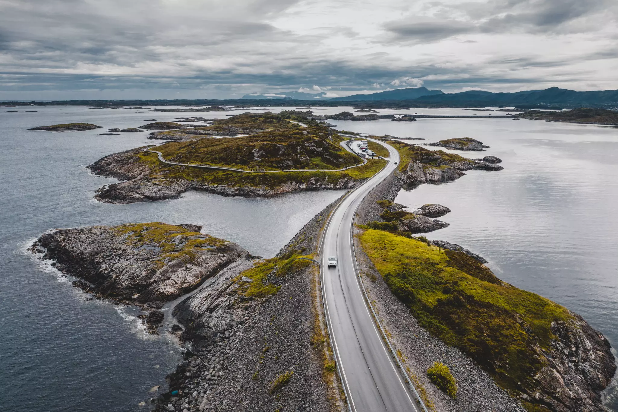
Beyond this, there is one more marvel to tackle three hours north of Ålesund – the Atlantic Road, on the way to Kristiansund. While it’s only 5 miles (8km) long, it squeezes eight bridges into that distance, including the twisting Storseisundet Bridge, which has featured in countless car commercials and movies. It’s an exhilarating ride, especially when the sea is up, and when I finally reach the long tunnel that will take me to Kristiansund, I’m ready for a beer.
Start – Bergen; end – Kristiansund; distance – 650km (404 miles), depending on which side roads you take
Getting there: Take a ferry to Oslo or Kristiansand and ride or drive. Alternatively, take a Hurtigruten ship. These run up the coast frequently and carry both bikes and cars.
When to drive: Between June and August, when Trollstigen is open.
Where to stay: Pre-book hotels or cabins at the many camping grounds.
Visas: Norway is part of the Schengen area. Many Europeans won’t need a visa, other nations should check.
You can find this drive – and over 200 more two- and four-wheeled adventures – in our Epic Drives of the World book. We have categorized this route as 'easy' taking into account not just how long, remote and challenging it is but the logistics and local conditions too.
You might also like:
When to go to Norway
Norway's top 9 hikes
The 11 best national parks in Norway
Norway is on our 2022 Best in Travel list. For more stories from some of the world’s most exciting destinations click here .
Safety recommendations and restrictions during a pandemic can change rapidly. Lonely Planet recommends that travelers always check with local authorities for up-to-date guidance before traveling during Covid-19 .
Take your Norway trip with Lonely Planet Journeys
Time to book that trip to Norway
Lonely Planet Journeys takes you there with fully customizable trips to top destinations – all crafted by our local experts.

Explore related stories