Jul 27, 20265 min read
The best time to visit MoroccoJun 21, 2016
13 MIN READ
Writer
The Kontodimos bridge, one of many arched stone bridges in the region. Justin Foulkes / Lonely Planet

Writer
Lonely Planet may earn a commission from affiliate links on our site. All recommendations and reviews reflect our own independent opinions.
This self-guided walking itinerary takes you from remote mountain villages to cliff-top monasteries, via the world's deepest gorge. Set out on foot to explore this lesser-known region of northern Greece...
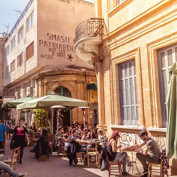
‘I want you to try everything, ’ says Elli Papageorgiou, emerging from the kitchen of her small café in the cobbled square of Kapesovo. She sets down a jug of sour cherry juice on a table heaving with food: cured sausage cut into rounds, fat green olives, garlic toasts heaped with tomatoes, and tiny cakes drenched in syrup. The jug lands with a clatter that startles a pack of sleeping dogs. ‘Besides, walkers need energy, ’ she says.
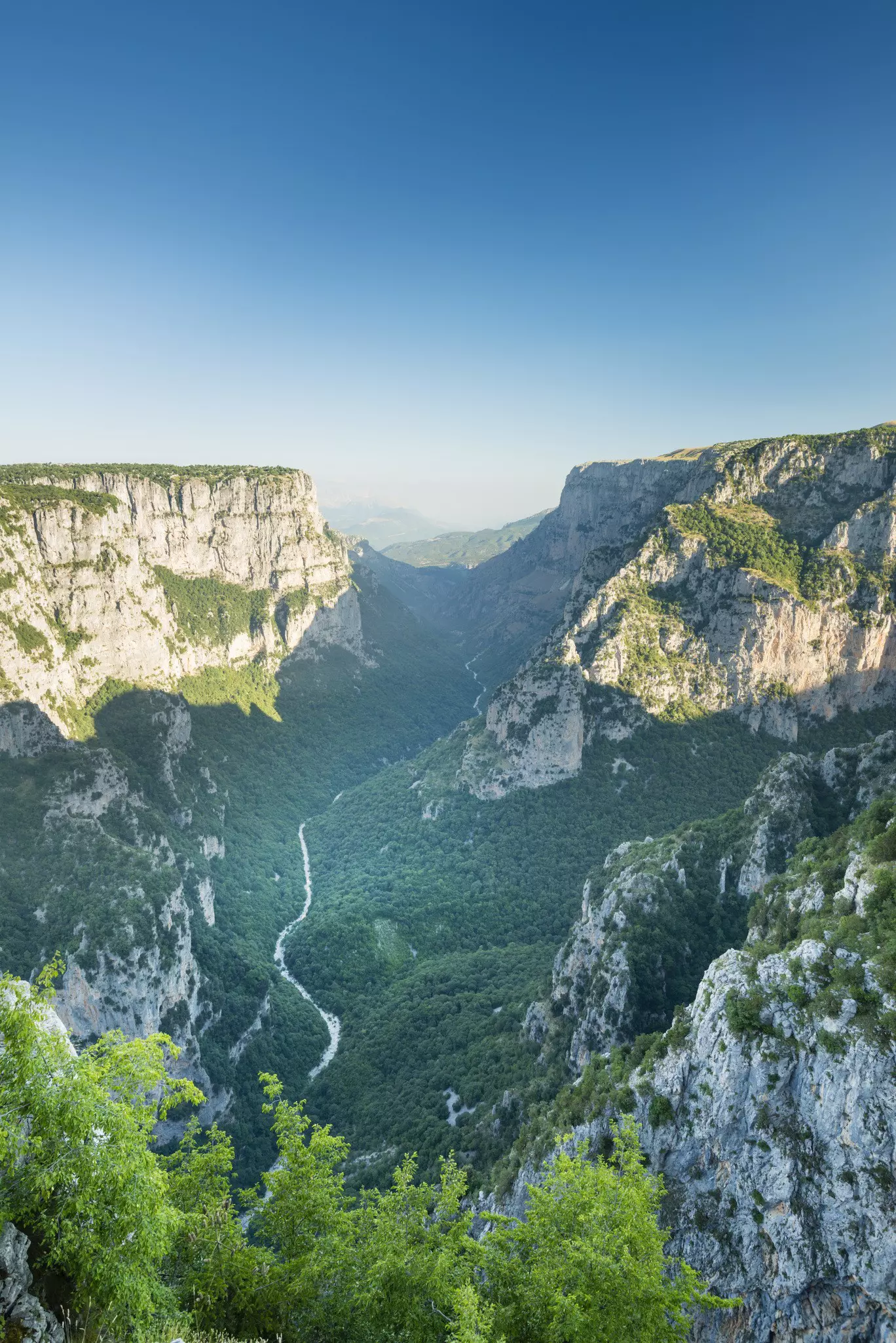
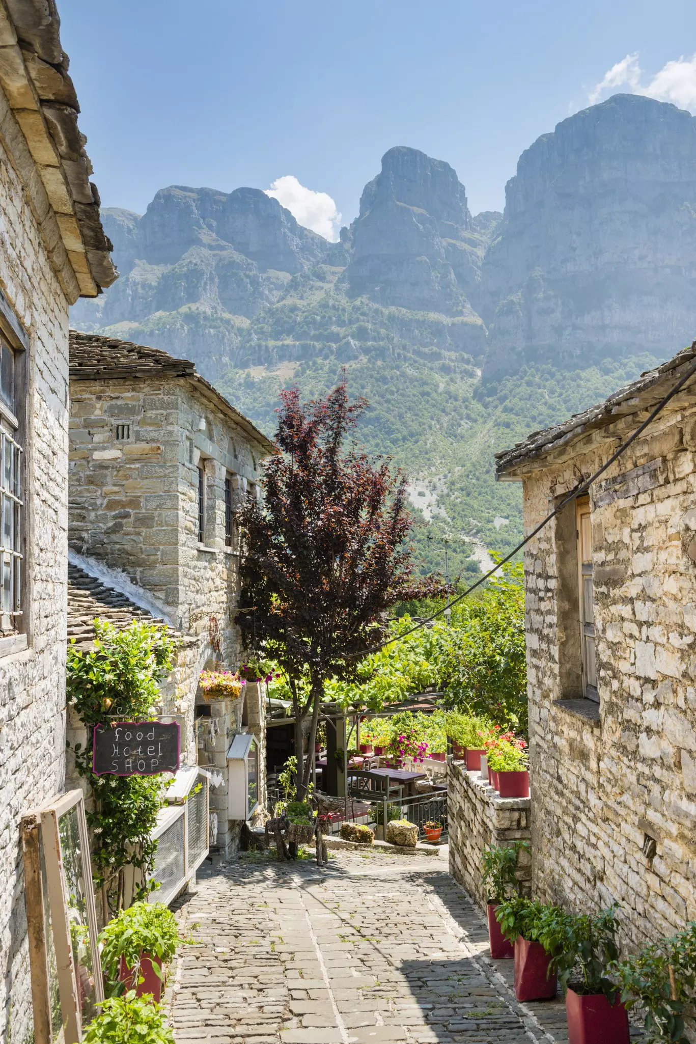
Philoxenia, meaning ‘love of a stranger’, isn’t just a word but a way of life in Greece – a deeply ingrained culture of hospitality that manifests, mostly simply, as an offering of food. Though the practice is perhaps a little strained in the popular islands, those who seek out the remote northern region of Zagorohoria tend to leave it as friends. For centuries footpaths were the sole routes connecting its 46 sandstone villages, and these ancient thoroughfares are still the most atmospheric way to get around. The area’s outstanding natural attraction, the Vikos Gorge – known as Greece’s Grand Canyon – can still only be explored on foot.

Kapesovo is one of the smallest of the picturesque grey-stone settlements, and offers a particularly warm welcome to walkers seeking a little RnR before they lace up their boots. Locals always find time to chat to visitors gathered at the pavement tables of Elli’s café, Sterna. While sitting in the shade of the village square’s giant plane tree with a glass of fiery local spirit tsipouro in hand, hours easily disappear.
6 miles, 3 1⁄2 hours
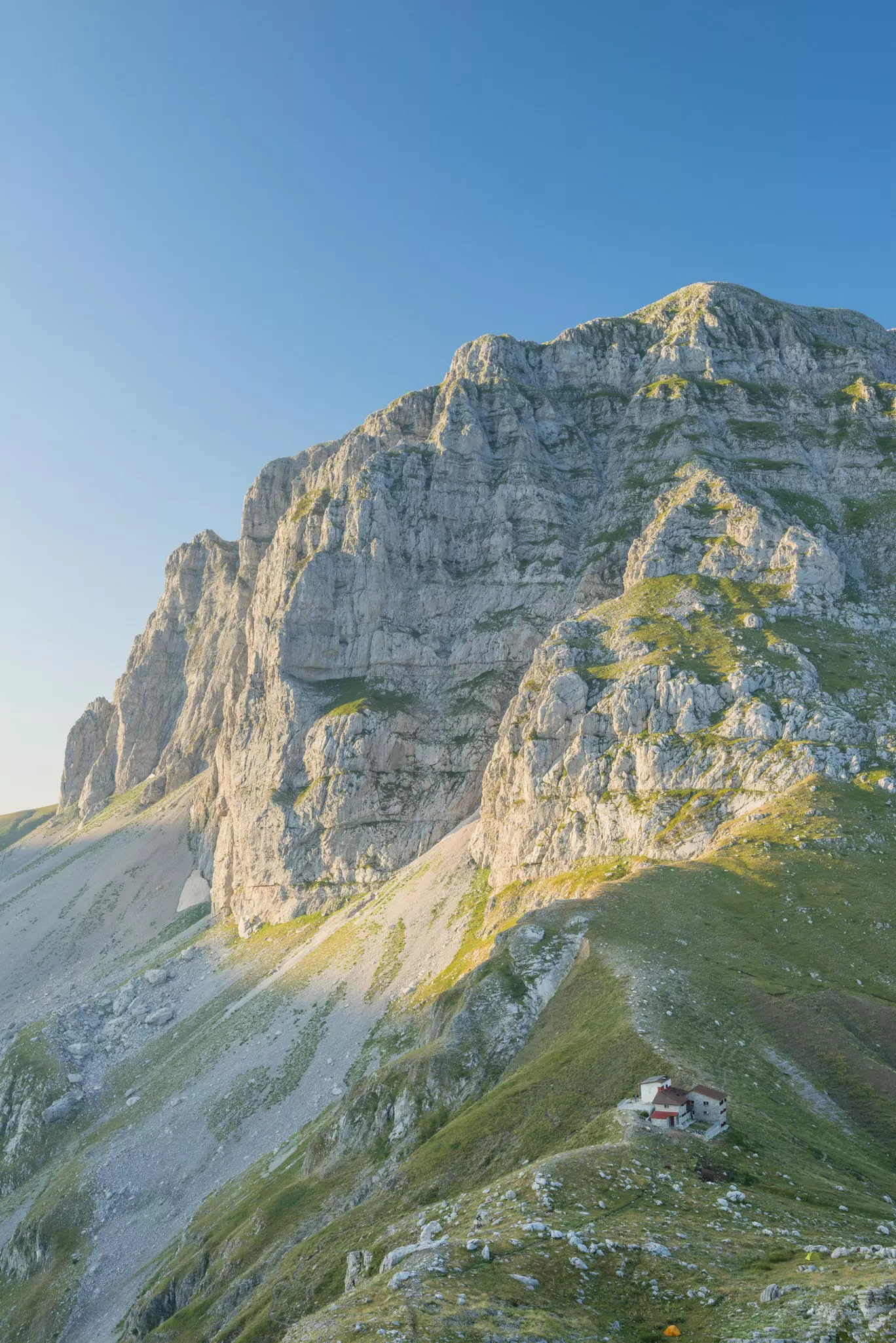
At 900m deep, Zagori’s Vikos Gorge is so enormous, its scale can only be appreciated from certain vantage points. Locals agree that the best of them is the viewpoint at Beloï: the word itself, probably Slavic in origin, means ‘good view’. As well as this unbeatable perspective, the walk here from Kapesovo offers a taster of the sort of terrain you can expect on subsequent (and more challenging) linear walks. It begins with a steep climb up the Vradeto Steps, cut into limestone cliffs like Escher’s never-ending staircase. Many mules have made their way up this old trading route over the centuries, and like them I walk the thousand steps of its dry stone path ploddingly.
The walk flattens out, passing a cluster of beehives circled by an electric fence (intended to keep out honey-guzzling brown bears, not uncommon in this part of Greece) and a tiny, unlocked chapel. Inside, saints and angels with gold leaf halos preside over unlit tapered candles. In the village of Vradeto, frogs swimming in the water trough greet walkers refilling a bottle. After a final scramble through shadowy woodland, nature makes its big reveal: the chasm of the Vikos Gorge, filled with spooling mist, the dry riverbed snaking into the distance like the tail of a retreating beast.
Retracing my steps back to Kapesovo, I find the village preparing for a party: the Feast of the Prophet Elias, its patron saint. A grill set up under a canopy of vines is laden with kebabs, filling the air with smoke and the scent of lamb cooked over coal. Grown-ups chat over cans of Mythos beer while children play chase around the square. As the night wears on, the melancholy songs of the musicians grow gradually more upbeat. When the music has reached a jig-like intensity, the villagers abandon their seats and join hands, twisting at the hips as they dance in ever-larger circles. There’s no plate smashing but a man in his sixties breaks free of the group to dance first on some shot glasses, then inside a baking tray, to laughter and applause from the crowds.
7 1⁄2 miles, 4 1⁄2 hours
The next morning the village sleeps in, the square deserted but for a cockerel, who crows lustily as if saying goodbye. Today’s walk will take me to one of the more visited of the Zagori villages, Monodendri, from where a path descends into the gorge itself. Paved stone soon gives way to rubble edged by wildflowers and their winged attendants, the yellow- headed flowers used by locals to make ‘mountain tea’ are swarmed by metallic, emerald-coloured beetles, and pale butterflies gather on feathery purple blooms. Dipping in and out of the shade of oak trees, I eventually reach the dry bed of the Voïdomatis River. Crossing it is a high stone arch: the Kontodimos bridge.
One of many built in the 18th and 19th centuries, this bridge – and the 91 others in the area like it – are a vestige of when these walkers’ paths were traders’ highways. During this time the Ottoman Empire ruled over Greece, but Zagorohoria was safeguarded by its remoteness: the Turks never really managed full control here. Instead, in exchange for guarding the mountain passes and collecting taxes on their behalf, they granted Zagorohorians semi-autonomy and other privileges. Local people grew increasingly prosperous, spending some of their wealth on the fine stone buildings still standing in the villages today.
It’s hard to imagine these pathways thronging with heavily laden mules. They are so peaceful that I encounter no-one at all, except when the path meanders into sleepy settlements – Koukouli, Vitsa– where locals drink iced frappes in the shade of plane trees. Every village has one, and by the time I reach Monodendri’s, the coffees have been swapped for beers, and the lights strung across the town square are already twinkling in the twilight.
9 miles, 6 1⁄2 hours
The world’s deepest canyon in proportion to its width, according to Guinness World Records, the Vikos Gorge is intimidatingly cavernous when viewed from afar, but strolling within it, it seems a sheltered idyll. Within minutes of leaving Monodendri, the path into it dips sharply, slipping under a dense arboreal canopy. Beards of moss hang from the branches of plane, oak and beech trees, and clusters of mushrooms bloom on long roots. Sprouting amid a carpet of bracken are Chinese money plants, their coin-like seedpods scattered along the path like a treasure trail.
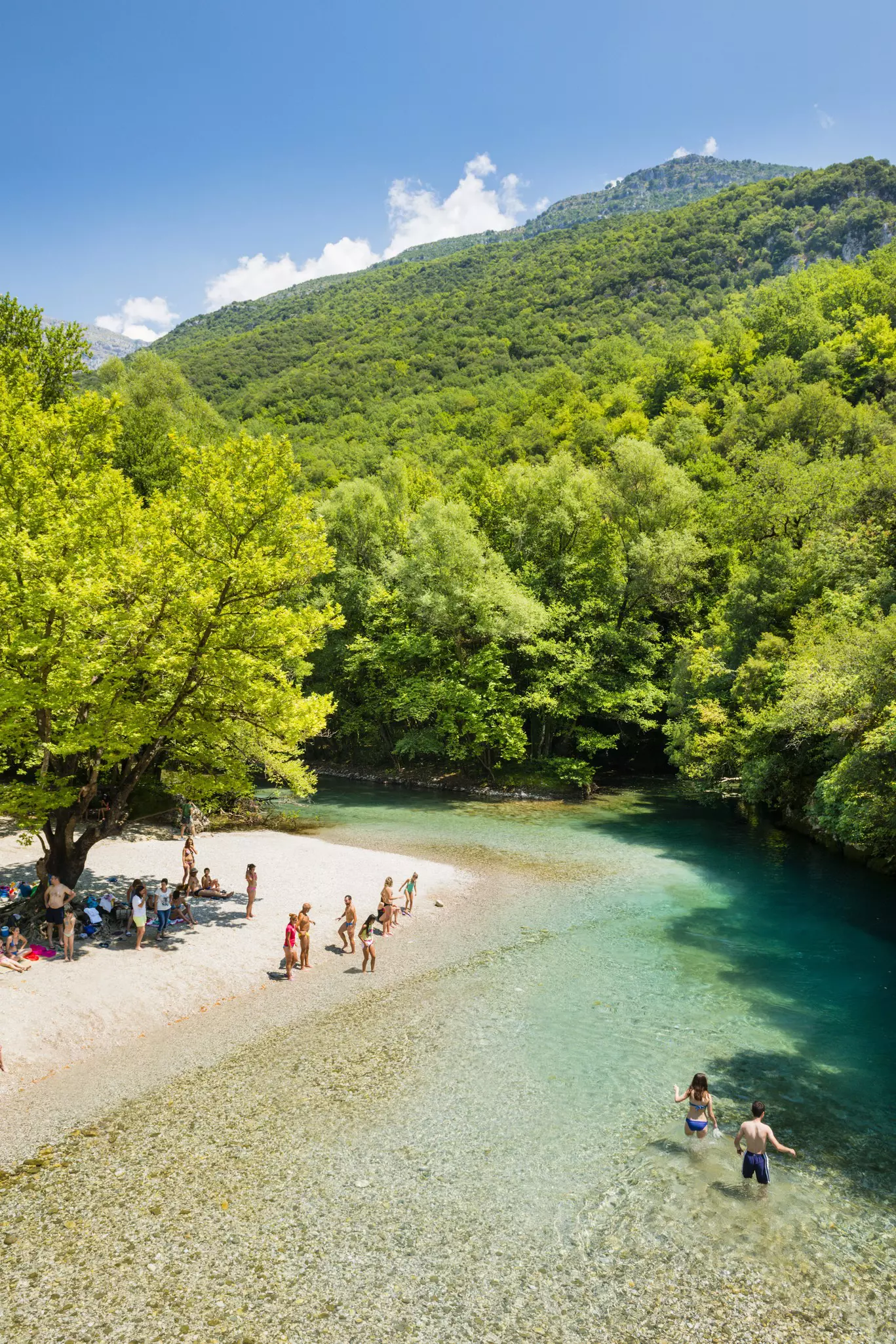
The riverbanks are a picture of luscious abundance, so springy with moss underfoot that I occasionally break into a gleeful, scampering run, but the riverbed remains dry. Limestone boulders usually submerged by water lie sun-baked and exposed. The walk alongside the empty waterway is so easy and flat that three hours pass by in a semi-trance. But suddenly there’s an unmistakable gurgle. Unlike the river with which it shares its name, the Voïdomatis spring never dries. Even in high summer, it’s icy. Two walkers – the first I have seen all day – cool their feet at one of the natural pools, but I cannot resist total submersion. Pond skaters shimmy across the surface, their long legs casting exaggerated shadows bigger than a bear’s paw.
Half an hour later, the path out of the gorge winds uphill, occasionally crossing scree slopes that leak flinty stones back into the abyss. From above comes the whistling of a shepherd, his flock bleating unseen in the foothills of Mount Astraka. There are still herders here who belong to the Sarakatsani tribe. Said to be the original Greeks, its people are traditionally nomadic but some have settled in Zagorohoria’s villages.
Among them is Tasos Tsoumanis, who has lived in Megalo Papingo for 25 years. When I arrive in the village he now calls home I bump into him and his friends congregated outside a small church, after a special service to mark another saint’s day, Agia Paraskevi. In festive mood, the group are heading on for lunch, and don’t hesitate to include a curious stranger. Sat in a fellow parishioner’s leafy courtyard garden, eating biscuits and drinking tsipouro, Tasos speaks of his people’s culture. ‘Even though the Sarakatsani move around for grazing, it’s the mountains that we consider our home, ’ he says, raising his tiny glass to an impressive moustache. When I tell him that tomorrow I will tackle the climb to Astraka, he nods approvingly. ‘I have always enjoyed hiking. To me it is important, each time, to go a little bit higher.'
4 miles, 4 hours to the Astraka Refuge; 4 miles, 2 1⁄2 hours to Dragon Lake and back. After an overnight stay, it's 2 1⁄2 hours from Astraka to Megalo Papingo
Tasos’s words ring in my ears as I set out on the trip’s biggest challenge: the 1000m ascent to the Mount Astraka refuge. Perched on a narrow ridge between two peaks of the Pindus Range, this takes walkers into proper mountain territory. The terrain is more open, the sun rising over swathes of dewy grass. But the climb has barely begun before streams of Lycra-clad superhumans steal my thunder. The runners are contestants in the longest of the annual Zagori Mountain races – a mighty 50 miles. Though Olympian both in appearance and focus, they are unfailingly polite, issuing a cheerful ‘Yassas!’ (Hello!) as they bound past at an intimidating pace.
Other walkers linger at the springs that punctuate the path as it zigzags broadly uphill. As we refill water bottles at the tap, the atmosphere is convivial. Nurse Thanusis Zafeiropoulos, who, with his broad frame and ponytail, has the look of a minor Greek god, is here with his preteen son, Paniotis. ‘There are many people who have taken up running during the economic crisis, ’ he says. ‘They run into the mountains to try to escape from the madness.’ He gestures down to the valley and laughs; the view, a sweep of green dotted with pretty stone villages, is one of unparalleled serenity.
When I arrive at the refuge, a simple lunch is being served: soup, bread and omelettes. At the communal table all the talk is of where everyone will go next. Some will climb Gamila, at 2,497m the highest peak of the Tymfi massif, while others are heading to Drakolimni: Dragon Lake. It sounds like a quest’s end plucked from a storybook, and is reached via landscapes that are similarly fantastical – a vivid green plain where hikers have written their names in pebbles, a meadow filled with alpine wildflowers, a dark cloud of chirping birds swarming through an otherwise empty sky. Arriving at the lake over the crest of a hill, I find two ibex standing sentry and the water, true to its name, full of baby dragons. Or at least large alpine newts, peering out from the reedy shallows. I spend hours lolling on the grass and swimming with the dragons, but eventually a thunderclap announces the arrival of a storm. As the clouds roll in I find myself inside one of them, and make my way back to my bunk bed at the refuge as if wading through ghosts.
From Megalo Papingo it’s a three-hour transfer by taxi/bus to Kastraki and Kalambaka, gateway towns to Meteora.
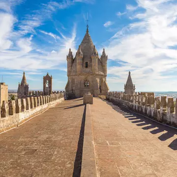
5 1⁄2 miles, 3 1⁄2 hours, circular walk taking in Grand Meteoron (from where Moni Agiou Stefanou can be reached by taxi).
It looks like a place made not by man, but by a higher power that parted the skies and placed a few buildings on top of these columns of rock. The actual explanation behind Meteora is scarcely less extraordinary. With origins in part stretching back to the 14th century, these monasteries are the work of hermit monks, who scaled sheer cliff faces to reach their building sites. To them, the location’s inaccessibility was an asset, a place of retreat from the bloody incursions of the Ottoman Empire, and offering a lofty seclusion that quite literally brought them closer to God.
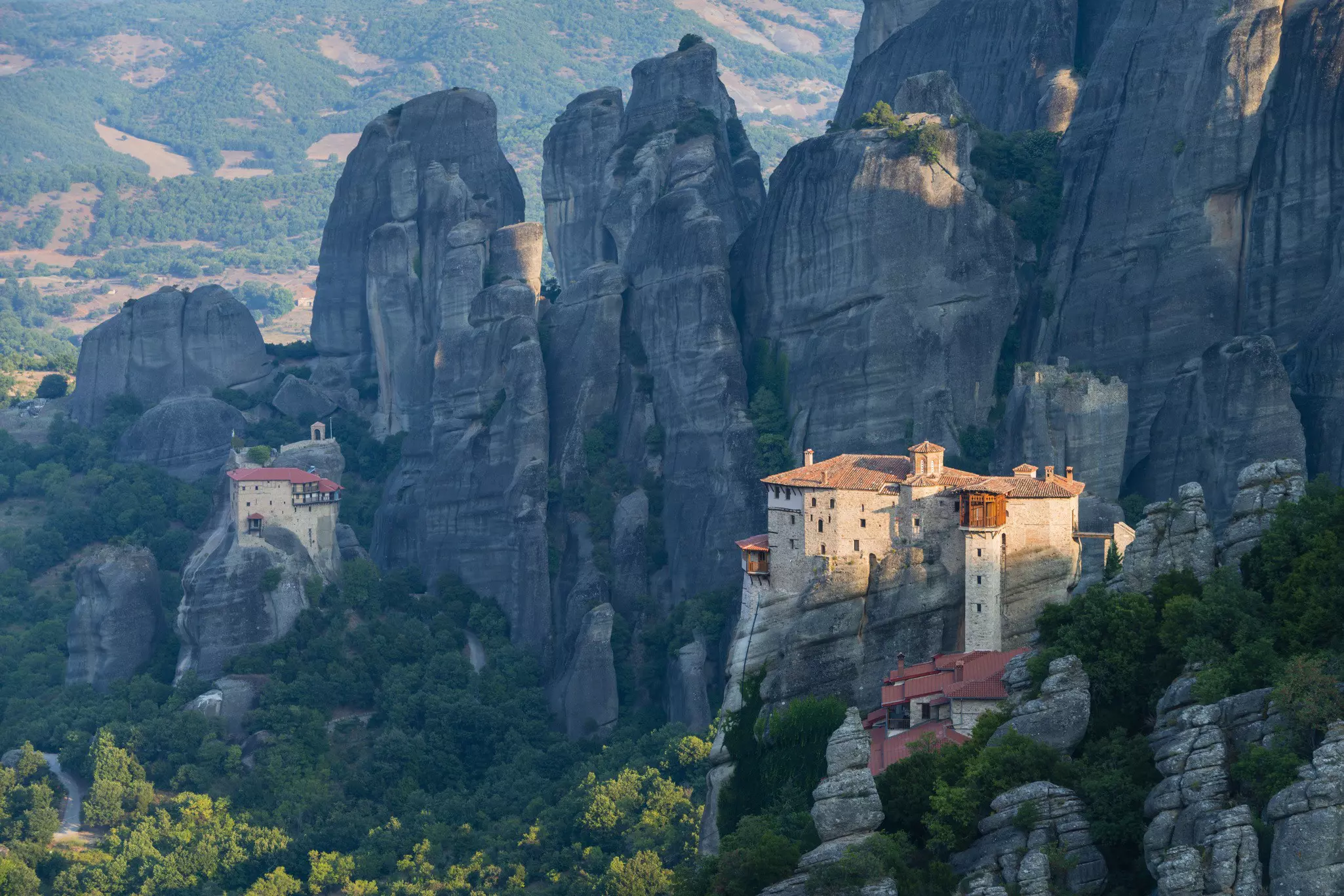
Setting out on my final walk – through arid scrubland, past empty tavernas and white houses – I spot a cliff face peppered with rock climbers: Meteora is one of the best places in the world for the sport. Their harnesses and ropes are a reminder that those who first made the climb did so without safety equipment, instead loaded down with bags of bricks. The first to be completed by this method was Grand Meteoron, which took 200 years to build. Perched on the valley’s highest peak, a mighty 613m tall, its name derives from the Greek adjective ‘meteoros’, meaning suspended in the air. Before steps were hewn into the rock face, both supplies and visitors were transported up in a windlass, which still dangles over the gorge. Local legend has it that if asked when the ropes were replaced, the monks’ standard reply was, ‘Only when the Lord lets them break.’
The Grand Meteoron brothers are mysterious figures, their dark robes, long beards and cylindrical hats glimpsed only fleetingly as they cross a courtyard or disappear behind a heavy wooden door. Visitors are most likely to come face to face with one at the sacristy, a small room where neat rows of shelves are lined with the skulls of previous residents. The first among them, the monastery’s founder Athanasios, is one of many religious figures represented in frescos in the monastery’s main church, their 16th-century colours still vivid.
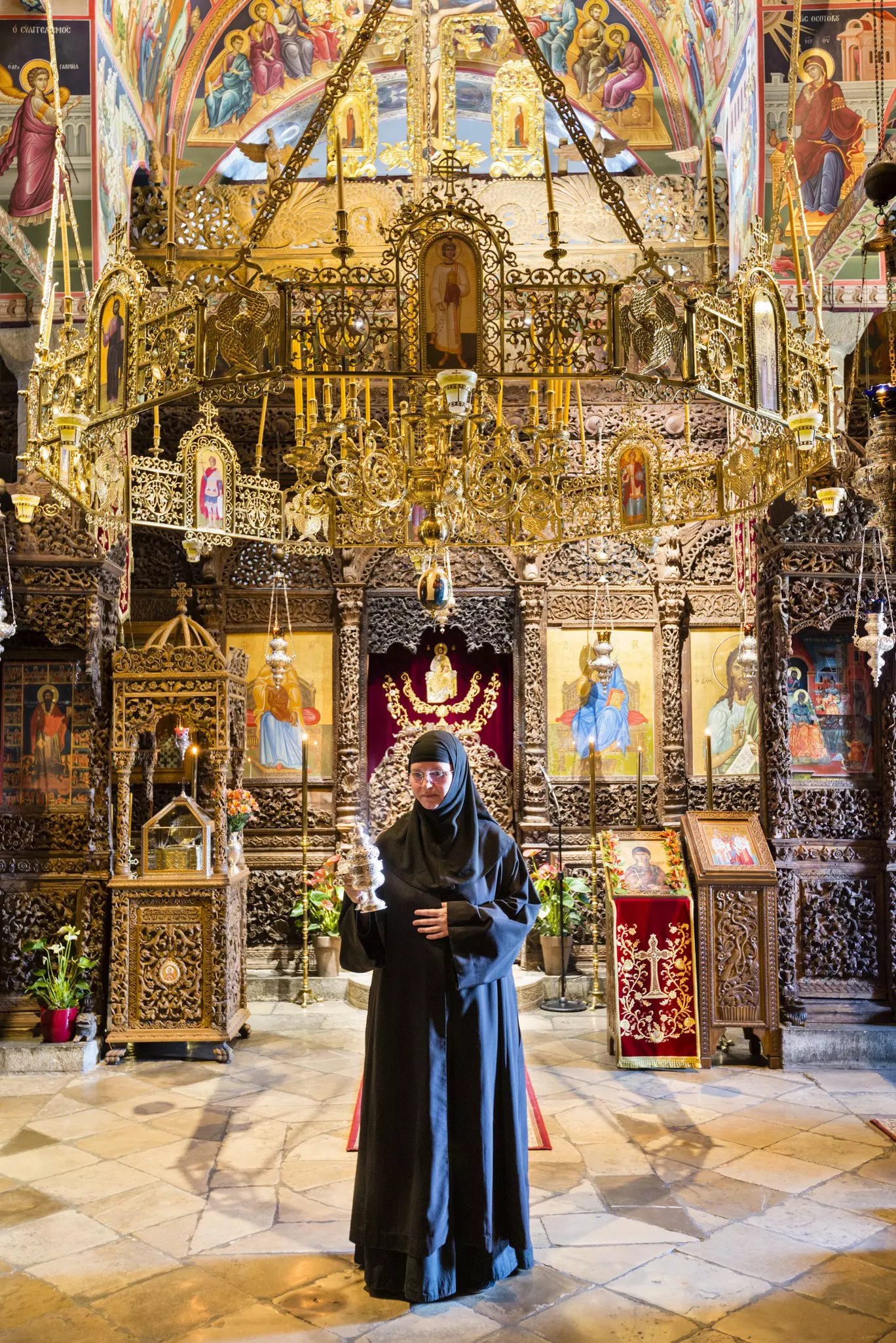
It’s not just monks who have sought refuge in Meteora. At the other end of the snaking road that connects the area’s six surviving monasteries is Moni Agiou Stefanou, a convent since 1960. Its inhabitants are altogether more visible. Nuns can be seen behind the till in a small gift shop selling religious icons, or gently tapping at a dark plank of wood used to summon the sisters to prayer. ‘Some people think our existence must be very boring, but there is a lot of grace and fulfilment in a peaceful life, ’ says Sister Silouani, a resident here for 22 years, as she shows me around Stefanou’s chapel, its walls rich with gold leaf. ‘On the rare occasions that I have to leave the monastery, I come back completely exhausted!’
‘This place was built rock by rock – can you imagine?’ she says, candlelight reflected in her spectacles. ‘We have a special respect for this holy place, built with such difficulty.’ For Sister Silouani, there is no contradiction in choosing a life of solitude in a nunnery that is open to the public. ‘If you love God, then you love all his people. Everyone who comes to Meteora comes for a reason, and if you embrace their presence – show them with a smile that you’re glad they came – it opens up their hearts.’
The monastery is due to close for the day but Sister Silouani, like all hosts in Greece, is incapable of letting me leave without first providing something to eat. She presses a foil-wrapped chocolate biscuit into my hand, and the gift feels somehow imbued with her goodness. Eating it slowly as I walk away, I am left feeling fulfilled, long after the last crumbs are gone.
This article appeared in the July 2016 edition of Lonely Planet Traveller Magazine. Orla Thomas travelled to northern Greece with support from On Foot Holidays, who offer a self-guided walk through the region (onfootholidays. co. uk). Lonely Planet contributors do not accept freebies in exchange for positive coverage.
Take your Greece trip with Lonely Planet Journeys
Time to book that trip to Greece
Lonely Planet Journeys takes you there with fully customizable trips to top destinations – all crafted by our local experts.

Explore related stories