7 Big Sur hikes to get you out of the car and onto the trails
Sep 8, 2021
7 MIN READ

Writer
Rocky coastline and the Bixby Bridge on Hwy 1 in Big Sur ©Ozéias Sant'ana/500px

Writer
Lonely Planet may earn a commission from affiliate links on our site. All recommendations and reviews reflect our own independent opinions.
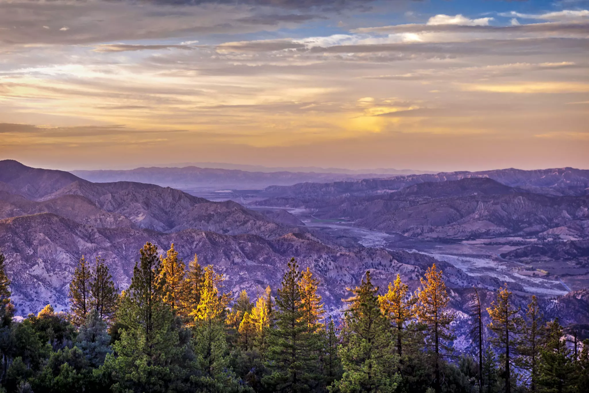
Big Sur easily qualifies as one America’s most iconic road trips, but to truly appreciate this impossibly dramatic juxtaposition of land and sea, you need to get out of the car and onto the trails. It’s a good thing that there are so many of them, allowing hikers to access deep canyons, dense forests and mountain meadows that can’t be seen from the road.
If you've ever dreamed of driving California's most famous coastal highway, the views are even better on foot. One important thing to note, however, is that most trails to the east of Highway 1 are now off-limits due to damage and erosion from wildfires, most recently the devastating Dolan fire in August 2020. Check the California State Parks website for trail closure notices and other information on the status of hiking to avoid disappointment.
This doesn’t mean there aren’t plenty of great options for hiking around Big Sur however. Here are the best Big Sur hikes, from north to south.
Soberones Canyon Trail and Garrapata Coastal Trail, Garrapata State Park
Best hike for whale-watchers
2.8 miles each way (1.8-mile loop for the Garrapata Coastal Trail); moderate
Just 7 miles south of Carmel Valley, Garrapata State Park is where locals go to enjoy nearly 3,000 acres of pristine hillside meadows and a secluded stretch of shoreline that is usually missed by those rushing south to Bixby Bridge and the area most people think of as Big Sur. Soothed by coastal fog, these former ranch lands are lush with wildflowers in spring and provide some of the coast’s most directly west-facing views, meaning some amazing sunsets.
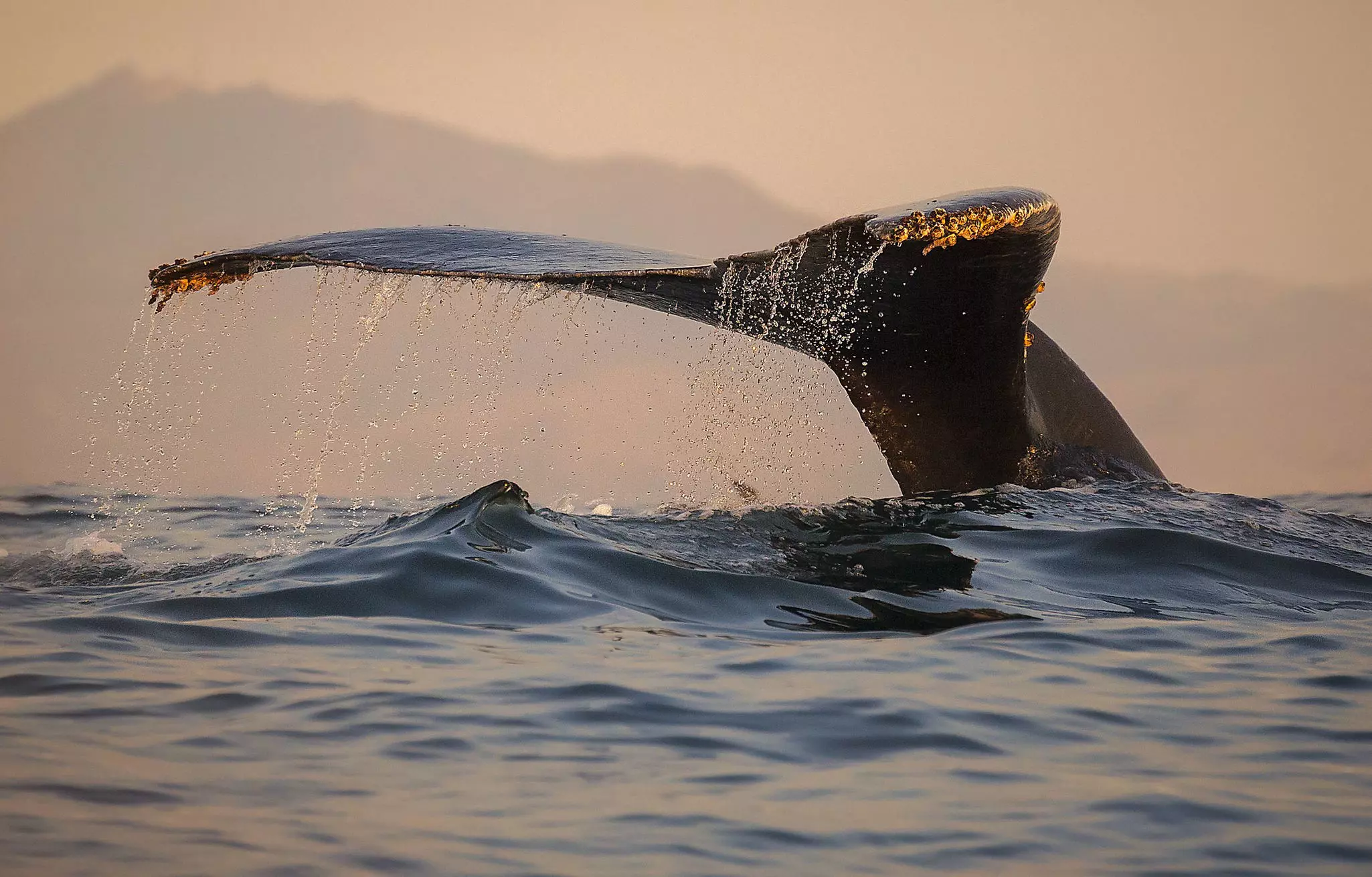
For a mid-length out-and-back trip, the Soberanes Canyon Trail follows Soberanes Creek through ferns and redwoods before ascending the hill for spectacular coastal views. The short loop around Soberanes Point and Whale Peak, accessed via the Coastal Bluff Trail, is a top choice for spotting gray and humpback whales during their winter and spring migrations.
Beach Trail, Creamery Trail, and Ridge Trail, Andrew Molera State Park
Best hike to a secret beach
2.3-mile loop to the beach; 8.7-mile loop along the ridge; easy to moderate
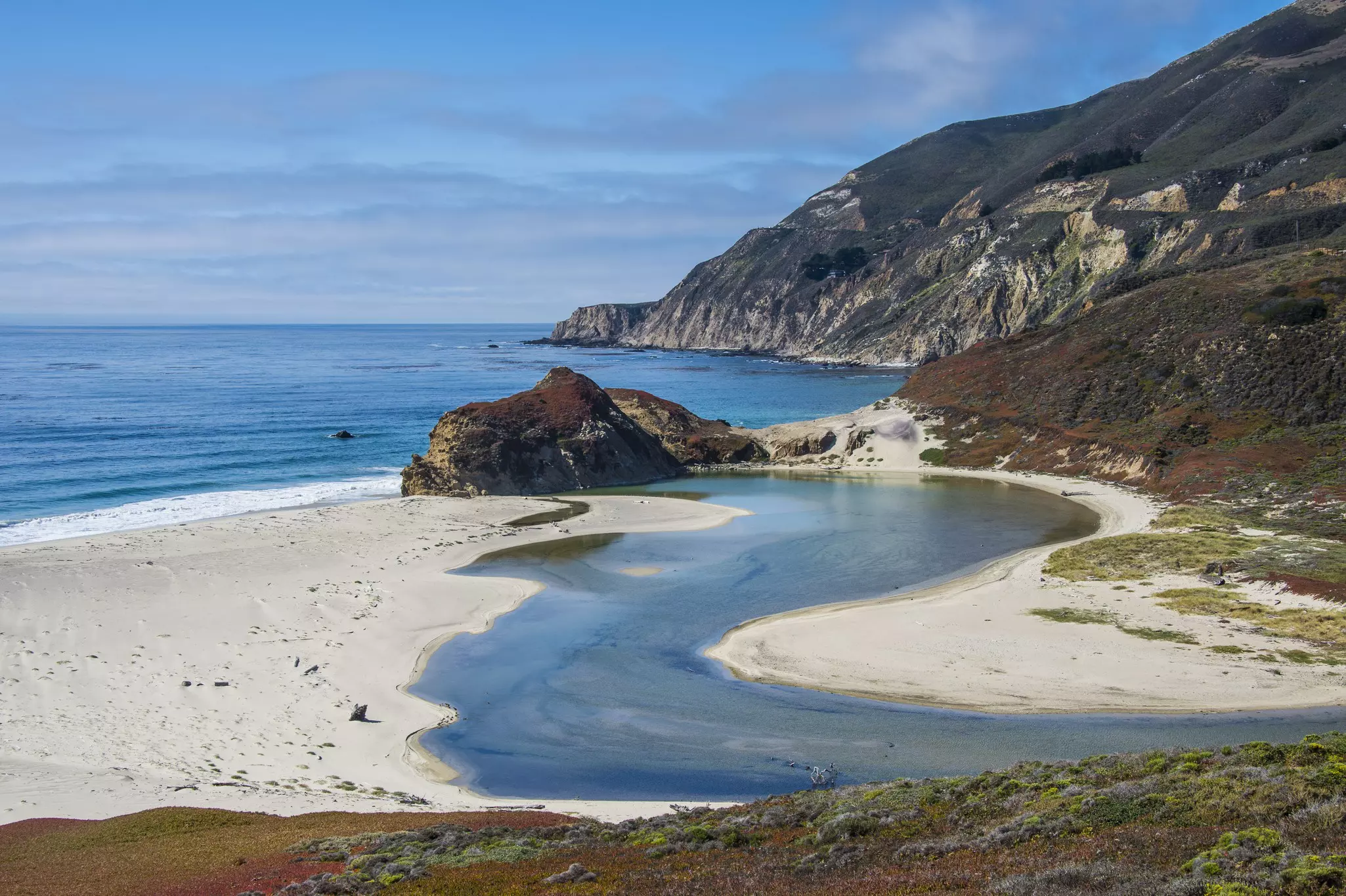
Many people come to Andrew Molera State Park solely to visit the protected beach at the mouth of the Big Sur River, but hikers know that this is only one of the park’s protected treasures. The best option for a looping hike to the beach is to go out via the Beach Trail and return via the Creamery Meadows Trail, which traverses lush grasslands once grazed by the cows of a local dairy.
You'll see much more varied terrain if you walk the 8.7-mile loop created by combining the Panorama Trail, Bluffs Trail and Ridge Trail, where stunning ocean views alternate with peaceful, shady patches of woodland. On this longer circuit, don’t miss the Spring Trail spur, which descends to the park’s extremely secluded southern beach.
Pfeiffer Falls and Valley View, Pfeiffer Big Sur State Park
Best hike for families
2.4 miles in total; Pfeiffer Falls Trail is easy; Valley View is moderate
Closed for over a decade for repairs, the Pfeiffer Falls Trail reopened in summer 2021 with a new boardwalk spanning the creek to protect this fragile ecosystem. Stairs and railings make the climb to the base of this pretty waterfall easier and safer–good news for younger and older hikers–and eloquent new signage provides colorful explanations of the area’s geology, ecology and history.
Starting from Big Sur Lodge, the trail splits into two, with the falls trail off to the right and the Valley View trail continuing up the hill. Together, these two routes make a satisfying 2.4-mile out-and-back trek, with the Valley View track terminating at a perfectly placed bench, seemingly suspended over the canyon below.
Buzzards Roost, Pfeiffer Big Sur State Park
Best hike for wildflowers
4.8-mile loop; moderate
Prepare to climb on this one: the Buzzards Roost trail switchbacks up Sycamore Canyon to a high ridge with 360-degree views over the Santa Lucia mountains. The full loop involves 810 feet of elevation gain, but you may not notice the effort as you soak up the scenery, with areas of coastal redwood forest and irises, columbines and other wildflowers lining the trail well into summer. Early morning fog can hide the views; leave this hike until late morning, or do it in the late afternoon or early evening when the 'golden hour' lights up the hills.
Pine Ridge Trail, Big Sur Station, Los Padres National Forest
Best hike for overnighters
12 miles each way; difficult
Few California trails generate quite the buzz that surrounds the Pine Ridge Trail to Sykes Hot Springs and the Redwood Camp from Big Sur Station. Once a historic post road connecting Big Sur Station to Tassajara Road in the Carmel Valley, the trail reopened in spring 2021 after being closed for almost five years due to damage from the 2016 Soberones fire and subsequent storm erosion.
Nature wasn’t the only troublemaker–over the years, the springs were dammed and channeled into man-made pools and tubs by hot springs enthusiasts, trashing the surrounding environment in the process. Enter the Ventana Wilderness Alliance and the National Forest Service: together, these two organizations restored the springs and now do their best to police the area proactively, discouraging people from causing further damage.
It’s a 10-mile trek to the hot springs and another two and a half to Redwood Camp, with possible overnight stops at the Terrace Creek and Barlow Flat hike-in campgrounds along the way. Continuing east will get you all the way to China Camp on Tassajara Road, traversing a large swath of the rugged Ventana Wilderness.
Tip: Because this trail traverses the Los Padres National Forest, it is subject to periodic closures to prevent wildfires; check the website for trail status reports before you head out here.
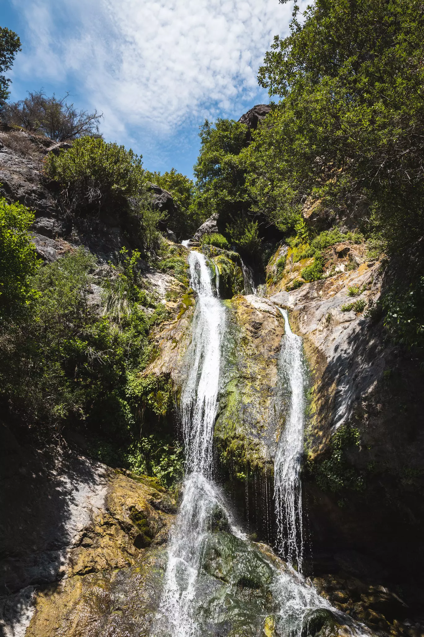
Salmon Creek Trail and Silver Peak Wilderness
Best hike to a hidden waterfall
Hike to falls ¼ mile; Silver Peak Wilderness 15 miles; difficult
Think of this hike as a bit of a treasure hunt, with spectacular Salmon Creek Falls just a quarter-mile in, but extremely difficult to find due to limited access through the steep, dense forest. Once you locate the creek, a chain of rock-lined pools leads up to the ribbon-like falls, though it requires some fairly serious boulder hopping to get an unobstructed view.
The trail climbs above the falls to a rocky outcrop with a hard-to-believe-it's-real view of the canyon dropping to the sea, and then continues its steep climb into the Silver Peak Wilderness area of the Santa Lucia Range. Ambitious hikers who think nothing of a 3,000-foot elevation gain can combine the Salmon Creek, Cruikshank, and Buckeye trails to make a 15-mile circuit through redwood groves, meadows, oak woodland and chaparral.
Tip: Because this trail is on Los Padres National Forest land, it is subject to seasonal closures to prevent wildfires; check the website before you head out for trail status reports.
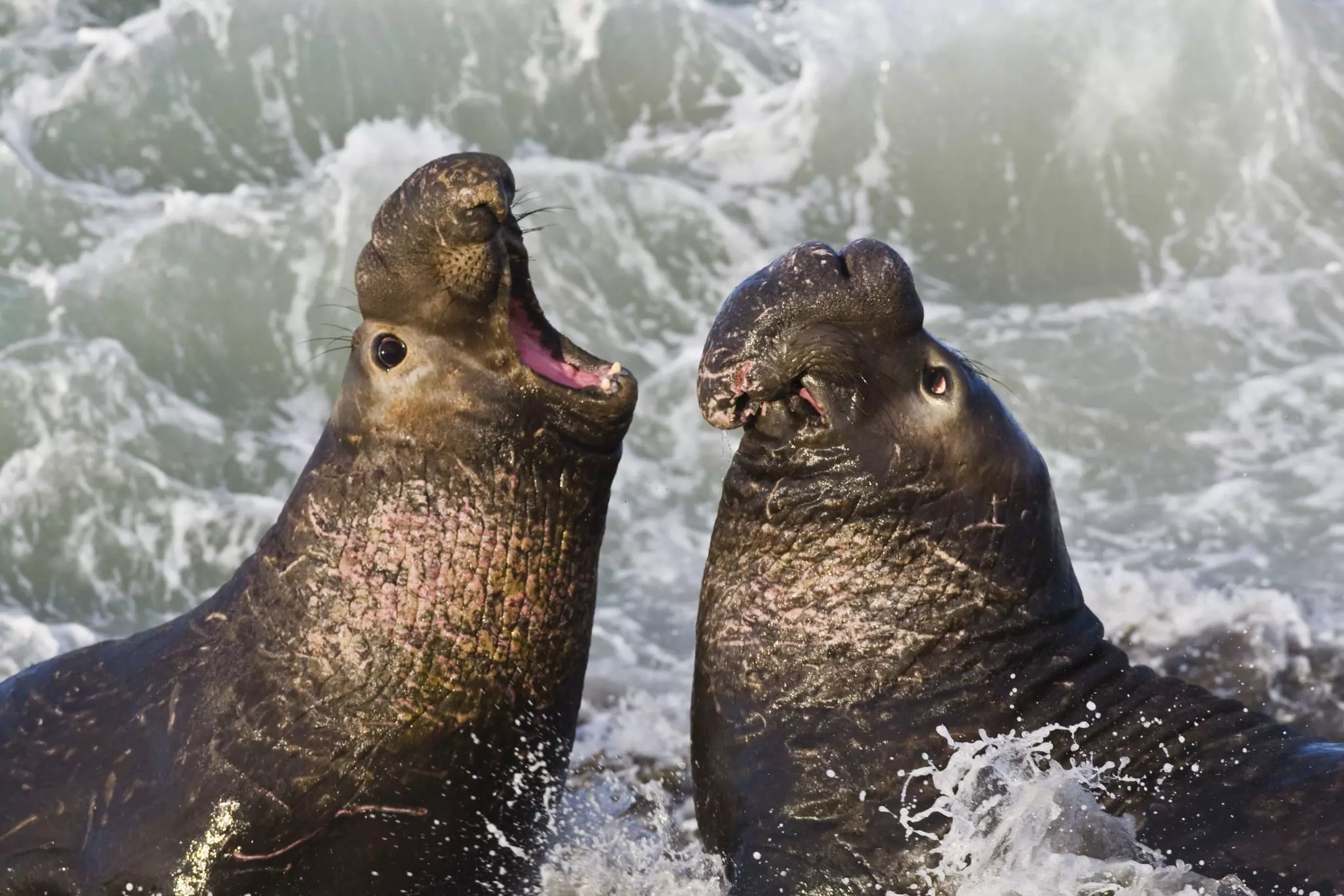
Boucher Trail, Piedras Blancas
Best hike for wildlife viewing
1.9 miles each way, easy,
If viewing the elephant seals at Piedras Blancas features on your California coast itinerary, add to the fun by hiking the Boucher Trail, a gentle meander along the bluffs, passing just below the historic Piedras Blancas lighthouse. Starting from the northern end of the elephant seal parking lot, this out-and-back trail continues for 1.9 miles along the cliff top; a second unmarked parking area by the highway at the north end of the track allows you to do the hike in reverse.
The lighthouse isn’t the only photo op on this mellow cliff-top meander. Two overlooks offer excellent views of the elephant seals below without fellow wildlife fans jostling at your elbows. While you’re here, take a guided tour of the Piedras Blancas Light Station; at 100 feet (30m), this was one of the tallest lighthouses on the West Coast when it was constructed in 1875, before earthquakes forced the removal of the upper levels.
You may also like:
9 bucket-list beaches in Big Sur
Sights and sweets along the California coast
Glamping in California: 5 spots to sleep comfortably under the stars