Colorado’s quirkiest road trip is the San Isabel scenic drive
Dec 6, 2019
5 MIN READ

Writer
The Sangre De Cristo Mountains loom in the distance on the road from Westcliffe in Colorado. spates / Getty Images

Writer
Lonely Planet may earn a commission from affiliate links on our site. All recommendations and reviews reflect our own independent opinions.
Fantastic mountain roads and epic views await visitors to Southeastern Colorado, where you can build your own San Isabel scenic drive around and through the beautiful San Isabel National Forest and its nearby towns.
Spectacular as it is, the scenery is only half the appeal. Marquee attractions like Pikes Peak and Garden of the Gods may get all the press, but just to the south are roadside oddities well worth a stop. Allow plenty of extra time for the many quirky attractions along the way.
San Isabel
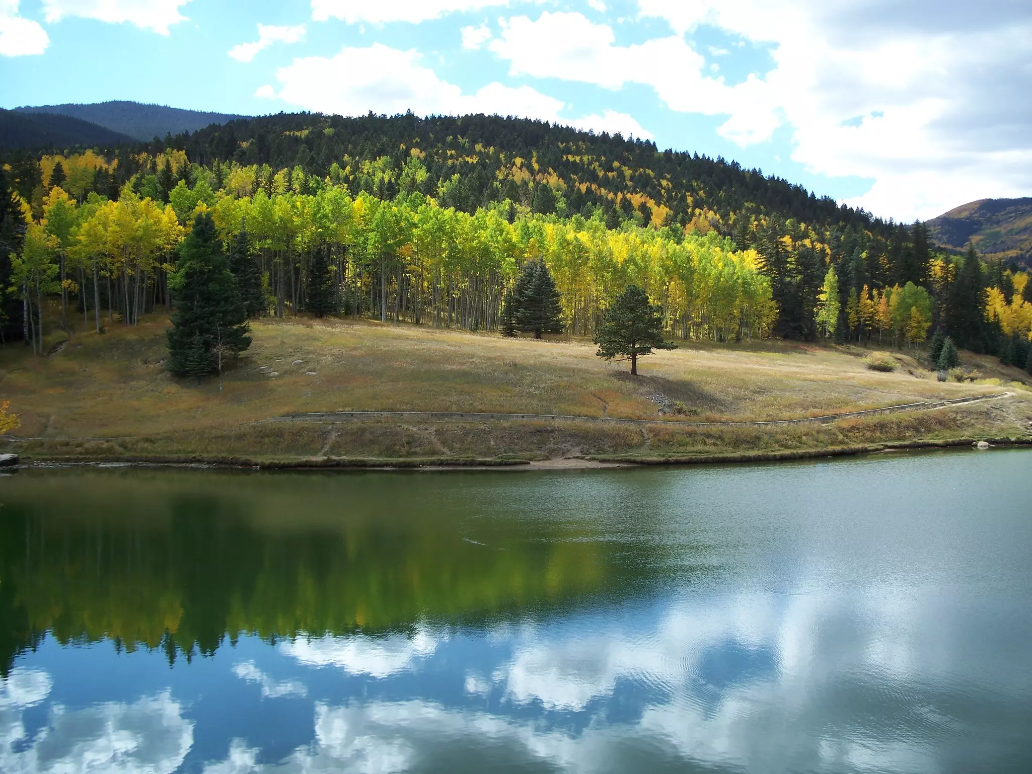
Begin at Lake Isabel, 40 miles southeast of Pueblo, along the Frontier Pathways Scenic Byway on state Hwy 165. This 35-acre lake (actually a reservoir, with a dam built in 1936 by the Civilian Conservation Corps) is surrounded by hiking trails and rustic 1920s cabins, with nearby campgrounds and picnic sites if you’re tempted to stay a while.
Related content The USA’s 12 best road trips and scenic drives
Want to stretch your legs? Check out the Cisneros Trail, with a trailhead at the far end of the campground access road – the well-trodden but fairly steep trail intersects the Marion Mine Route to make a 4-mile loop hike through an alpine forest to an abandoned mine.
In summer you can fill up on a Texas burrito or chicken-fried steak at the CCC-built, family-run San Isabel Lodge (8am-8pm Wed-Mon Jun-Aug, 8am-3pm Sat & Sun Sep), where you can also rent boats, kayaks, and cabins.
Bishop Castle
From Lake Isabel, it’s just a couple of miles north on Hwy 165 to reach the truly amazing Bishop Castle. Local eccentric Jim Bishop started work on this wonder in 1969, adding to it bit by bit over the years, using no heavy equipment – just his own two hands and a wheelbarrow. It’s hard to describe the effect of seeing a full-size, multi-story, turreted stone castle, with a fire-breathing dragon on top, poking up from the middle of a national forest.
Adding to the surreal effect are the building’s multiple obvious safety hazards (large holes in key places on sagging wrought-iron stairs, crumbling sections of wall here and there, and generally a lot more movement than feels comfortable). Hand-painted signs alert visitors to the Bishops’ dim view of governments, authority figures, and rules in general. Free; open 24 hours.
Related content A Western US road trip playlist to bring out your inner desperado
Westcliffe & Silver Cliff
Continuing northwest along Hwy 165 for 12 miles, follow the route of the Frontier Pathways Scenic Drive, turning west on Hwy 96 and continuing for 16 miles toward the small, adjoining towns of Westcliffe and Silver Cliff. The sudden view of the peaks lined up before you as you leave the forest is a sight to behold.
Westcliffe has a gas station and a handful of places to eat (try the Sugar & Spice Mountain Bakery for fresh pastries). If it’s a summer weekend, stop in at the Silver Cliff Museum, in the old fire station, for some local history. Silver Cliff is basically a ghost town now, but in the 1870s it was the place to be, its streets thronged with miners and lined with saloons full of gamblers and dancing girls. Sadly for the town, when silver dwindled and taxes rose in 1885, most of the town moved their houses (literally) into cheaper Westcliffe instead.
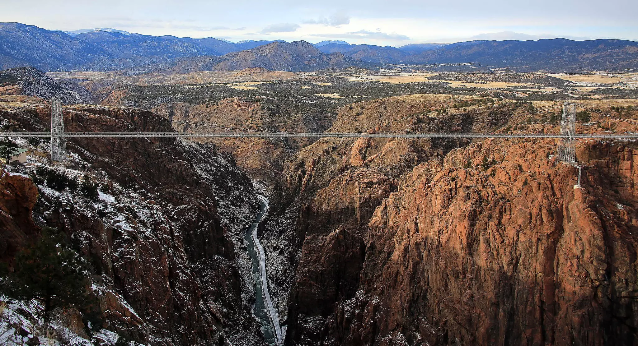
Royal Gorge
Leaving Westcliffe, head north on Hwy 69 for 24 miles until it meets Hwy 50, where you turn east and continue for about 20 miles. The next stop is the tourist-friendly Royal Gorge, with the highest suspension bridge in the United States, built in 1929. The gorge complex includes gondolas, ziplines, and a new via ferrata, a cabled climbing route with iron rungs allowing visitors to scale the steep canyon walls, led by a trained guide.
Related content Afraid to climb? Try a via ferrata instead
If your road-trip party includes kids, or fans of the Jurassic era, stop at the Royal Gorge Dinosaur Experience to see its collection of fossils and interactive science displays. A ropes course outside the museum provides a break from being cooped up in the car.
Florence & Cañon City
As you leave the Gorge, turn right toward Cañon City – home of the Royal Gorge Museum & History Center and the somewhat bleaker Museum of Colorado Prisons, which details this area’s primary industry. Cañon is also a good place to stop and refuel, with plenty of restaurants, grocery stores, gas stations and hotels.
Continue heading east on Hwy 50 for 15 miles, then follow signs to Florence (state Hwy 67 south).
Florence is a small town with an attractive, walkable historic core, but it’s mainly known for the prisons that surround it (including the country’s only supermax, where the Unabomber and El Chapo have been held). Most visitors, however, come for the galleries and antique stores that line the main drag.
Completing the Scenic Drive Loop
From Florence, you can either wrap up your San Isabel scenic drive by heading directly to Pueblo along Hwy 50 or continue the tour by driving south along Hwy 67 for 12 miles to the cluster of ramshackle buildings that is Wetmore, a small community established by settlers in the 1870s.
From Wetmore it’s a 10-mile stretch of glorious, winding road (along Hwy 96) through a tree-lined, cliff-edged canyon to the intersection with Hwy 165 and the completion of the loop.
One note of caution before you set out: these roads are all at high elevation, which means weather can be unpredictable, so be sure to check the forecast and road conditions at COtrip. org before heading out.