Guide to hiking Camelback Mountain in Phoenix, Arizona
Aug 11, 2025
7 MIN READ

Writer
Highlights
Lonely Planet's editors guide hikers up Camelback Mountain, one of Arizona's top hikes.
Hike October to May; summer heat can close the trails from 11am to 5pm.
Both trails demand rock scrambling; wear ankle-support boots and carry 68oz of water minimum.
The rocky summit delivers 360-degree views of the Valley of the Sun, Phoenix's metro area.
Sunset over Camelback Mountain in Phoenix, Arizona. antsdrone/Shutterstock

Writer
Highlights
Lonely Planet's editors guide hikers up Camelback Mountain, one of Arizona's top hikes.
Hike October to May; summer heat can close the trails from 11am to 5pm.
Both trails demand rock scrambling; wear ankle-support boots and carry 68oz of water minimum.
The rocky summit delivers 360-degree views of the Valley of the Sun, Phoenix's metro area.
Lonely Planet may earn a commission from affiliate links on our site. All recommendations and reviews reflect our own independent opinions.
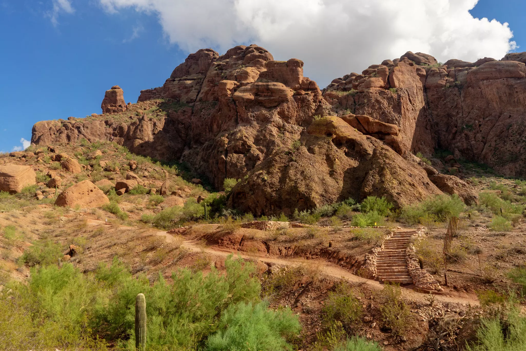
Resembling the head and hump of a kneeling camel (if you squint a little and use your imagination) Camelback Mountain is one of Phoenix’s most recognizable landmarks. Rising to 2704ft, this is the highest point in the city, and two challenging hiking trails climb to the top, offering dizzying views over Arizona’s state capital.
Located a 20-minute drive from the center, ringed by residential neighborhoods, this iconic peak will give you a taste of Sonoran Desert scenery inside the city limits. Whether you tackle the Echo Canyon Trail or the Cholla Trail, the strenuous climb to the summit is one of the most popular experiences in Arizona.
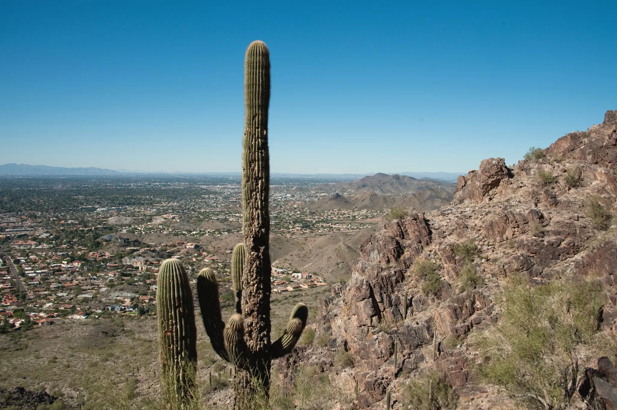
After a steep ascent, hikers are rewarded with 360-degree views across the Valley of the Sun – the local nickname for the Phoenix metropolitan area. However, be aware that this is a trek for experienced, well-prepared hikers. Many people have ended up needing to be rescued after underestimating the difficulty of the trail, or injuring themselves on the uneven terrain.
If you feel up to the challenge of one of the top hikes in Arizona, here’s how to hike to the top of Phoenix’s Camelback Mountain.
When is the best time to hike Camelback Mountain?
You’re in the Sonoran Desert, so it pays to respect the climate. Summer temperatures can reach 106ºF (41ºC), and there isn’t much shade in this rocky, largely treeless terrain. Sensible hikers avoid the hike up Camelback Mountain in summer, when the trails are often closed from 11am to 5pm due to excessive heat warnings.
The walk is much more enjoyable when it’s cooler, from October to May, though this is also the busiest time to hike, particularly at weekends and during holidays. Hike during the week if possible and arrive as soon as the trails open to avoid the crowds. Camelback Mountain is officially open from sunrise to sunset, and this is enforced by rangers – you’ll risk a fine if you stay later.
The peak is one of the busiest hiking spots in the Valley, so arrive as early as possible to nab a parking spot. The Echo Canyon Trailhead has a designated parking lot, but vehicles are turned away when it’s full. There’s no parking lot at the Cholla Trailhead, but limited on-street parking is available on some nearby roads. Consider coming by rideshare to eliminate the need for parking.

What should I expect on the trek?
There are two trails up Camelback Mountain – the steep and challenging Echo Canyon Trail, and the slightly less steep, but still challenging, Cholla Trail. Both start fairly gently but quickly become rocky and uneven as you gain elevation. There are lots of rocks to step over, and there isn’t much in the way of shade.
On the later stages of the ascent, you’ll find yourself scrambling over bare rock or up boulder-filled gullies, with fencing for protection on exposed sections. Be sure to carry plenty of water – potable water and restrooms are available at the Echo Canyon Trailhead, but not at the Cholla Trailhead.
The reward at the top is the kind of view normally reserved for pilots steering jets into Phoenix Sky Harbor International Airport, with the city spread out like a topographical map, looking oddly flat against the rocky ridges rising on the horizon. Sure, it can get crowded at the top, but there’s no better place to get a feel for how Phoenix is laid out, and how the city has grown since its foundation in 1867.
What do I need to pack?
You’ll need comfortable hiking shoes or boots with good ankle support – the terrain is uneven, and it’s easy to lose your footing or turn an ankle if you are not careful. The walk is less strenuous on the way down, but also tougher on the knees – take it slowly.
Bring plenty of water – The Arizona Department of Health Services recommends 68oz (2L) as a daily minimum, and it’s important to drink regularly as you walk the Camelback Mountain trails. You’ll also need sunscreen and a hat to keep off the sun; use SPF30 or higher and allow it to soak in for 20 minutes before you set off.
Hiking Camelback Mountain on the Echo Canyon Trail
Starting from the Echo Canyon Trailhead parking lot, this popular trail gains 1264ft of elevation over 1.2 miles on the steeper, more direct route to the summit. While the overall distance is short, this is not a hike to be taken lightly; allow two to three hours for the 2.5-mile return trip.
Approaching Camelback Mountain from the northwest, the Echo Canyon Trail is steep, intense and absolutely worth it for those who can manage the physical demands. Massive red sandstone rock formations line the trail, giving way to glinting Precambrian granite at higher elevations, and the dirt path becomes a scramble over exposed rock as you get closer to the top.
Watch your footing, rest when you need to, and make use of the metal handrails on steep sections of the trail. The views just keep getting better as you follow the ridge and climb to the top of the camel’s “hump” but don’t leave it too late to head back down – Camelback’s rangers are quick to ticket any cars that remain in the Echo Canyon Trailhead parking lot after sunset.
Hiking Camelback Mountain on the Cholla Trail
The Cholla Trail approaches the summit from the southeast, covering 2.6 miles out-and-back. This route is typically referred to as the “easier” of Camelback’s two trails, but don’t be fooled by the slow start – the ascent quickly gets steeper and more challenging. As for the Echo Canyon Trail, allow two to three hours for the return trip.
While the incline is more gradual than on the Echo Canyon Trail, the Cholla Trail is entirely uphill and exposed in places, and you’ll have to pull yourself up over large rocks to reach the summit. When you return to these rocks on the way back down, you may need to get down on your backside and scoot for parts of the scramble.
With the lack of amenities at this trailhead, be sure to stock up on water (and use the restroom) before you come. There’s a secret detour on the Cholla Trail – ask locals how to find the hidden cavern tucked out of sight on a rounded bluff, opening onto the view.
Other rewarding hikes in Phoenix
Covered in saguaro, ocotillo and teddy-bear cholla cacti, the picturesque summit of Piestewa Peak (2608ft) is another popular Phoenix hiking destination, thanks to the stunning views of downtown waiting at the top. The peak was previously known as Squaw Peak, but it was renamed for a local soldier, Lori Piestewa, who died in 2003.
Be warned – the summit trek is steep and difficult, with 1200ft of elevation gain over 1.2 miles. There isn’t much shade, and you’ll need to carry plenty of water. Allow two to three hours to reach the top, admire the view and return to the 302 Trailhead. For an easier hike, follow the Freedom Trail (3.7 miles) around the base of the peak from the same trailhead (look for parking along Piestewa Peak Dr).
There are nearly 70 trails in the surrounding Phoenix Mountains Preserve, so you have lots of other hikes to choose from. However, with the proximity of downtown Phoenix, the trails can get jammed on weekends; walking on weekdays is a calmer experience.
This article was adapted from Lonely Planet’s Southwest USA guidebook, published in August 2025.