In the last couple of decades, the likes of Costa Rica and Panama have transformed Central America into one of the world's adventure havens. It's a land scored by smoking mountains, threaded with coconut-dotted beaches and dressed from head to toe in jungles packed with sloths and slithering snakes.
This guide to eight of the region's best hiking trails will hop from the wave-bashed Pacific to the untrodden reaches of the Darien Gap. The aim? To reveal Central America's finest trekking paths and day hikes, with something for all levels, beginner to Bear Grylls.
Sendero el Perezoso – Costa Rica
Best for wildlife viewing
1.3km (0.9 miles), 30 minutes, easy
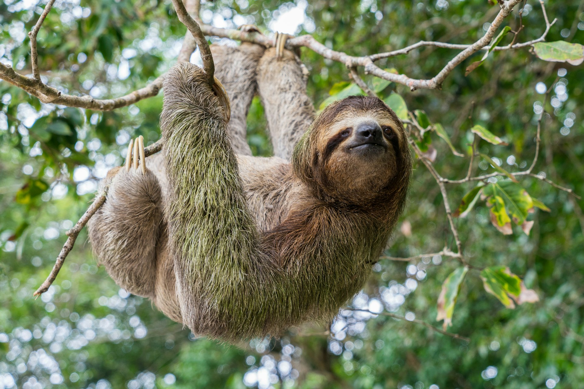
Ask 10 people why they came to Costa Rica in the first place, and sloths are likely to feature somewhere in the answer. Cue this short detour off the main Park Trail in that ground zero of biodiversity, Manuel Antonio National Park, built to offer hikers access to some of the most sloth-rich jungles in the world – hence its name.
The Sloth Trail begins less than a 10-minute walk into the forest from the reserve's main entrance. Take the spur that leads off to the west and follow the raised boardwalk pathways; soon you'll be dwarfed amid phalanxes of silk cotton trees and buttonwoods. They're known to host two- and three-toed sloths, but spotting the critters can be tricky – they hardly make a move! Try to get on this one nice and early, because there are more sloths when there are fewer people.
The end of the trail connects to the main intersection for all routes through Manuel Antonio. That's a great place to be, what with the cinnamon sands of Playa Espadilla Sur on one side and the route to the much-photographed scythe of powder at Manuel Antonio Beach on the other.
Volcán Concepción – Nicaragua
Best for a challenge
16km (9.9 miles), 11 hours, challenging
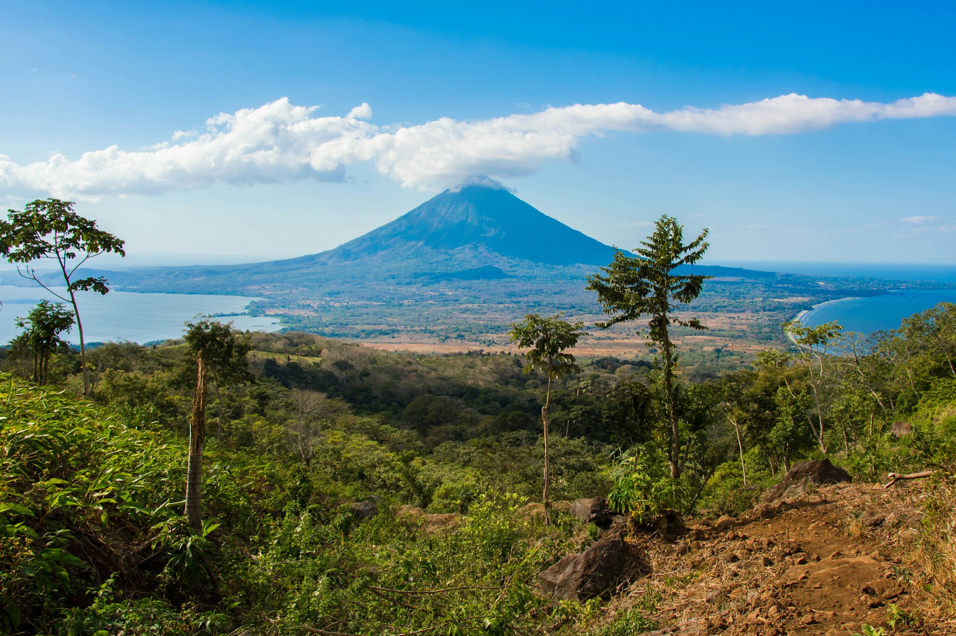
Volcán Concepción is one of two cone-shaped summits that keep watch over Lago de Nicaragua, the largest freshwater lake in Central America. It might not look it, but it's doable in a single push; just leave early, because it'll take 10 to 11 hours for most, and the cool morning air is a blessing on the initial ascent.
Speaking of ascents, the real killer here is the altitude gain. The summit is at a relatively mild 1610m (5282ft), but the base level of the hike is a mere 130m (427ft), meaning it's a long way to go before you hit the top. First sections are through lush jungle, and then you get a zigzagging mud track up the spine of the mountain.
The final leg above 1200m (3937ft) is trickier. That's where the scree takes over, and there are steep parts where you might be asked to scramble against a vertigo-inducing backdrop of swirling lake waters and surrounding coffee plantations. But there's a reward: clear days at the top mean visions of a cloud-wisped crater rim. and even Mombacho Volcano far to the north.
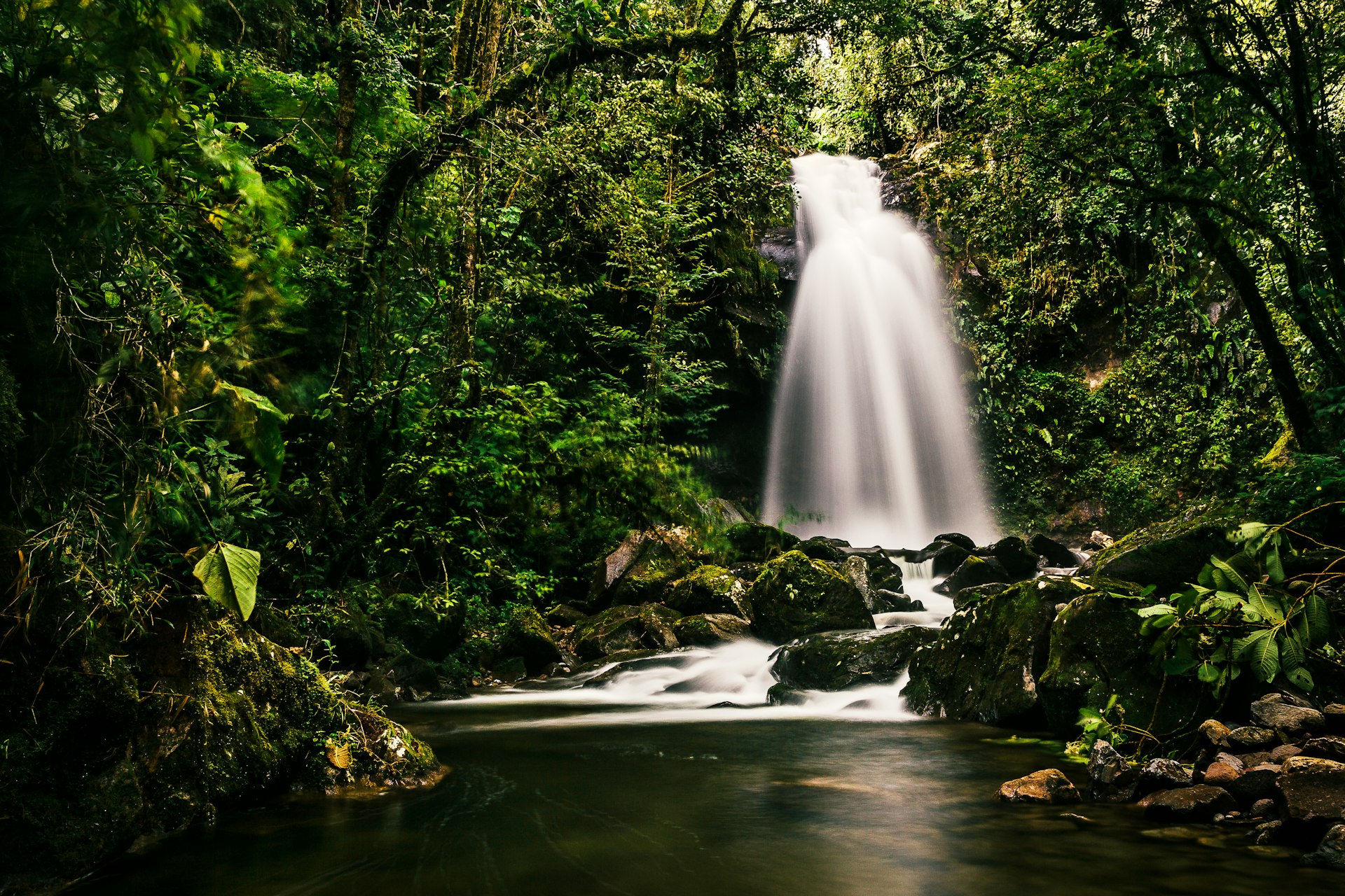
Lost Waterfalls Trail – Panama
Best for waterfall lovers
3.3km (2.1 miles), 2-3 hours, easy
The good news is that none of the three waterfalls on this hike are lost, exactly. In fact, they're pretty well known, as this is surely one of the most popular out-and-back routes in the eco mecca of Boquete. The point is they feel lost, because you'll need to navigate through Amazon-thick jungles woven with lianas and spiderwebs to reach them.
The waterfalls themselves are strewn almost equidistance along the route. The first is the biggest, a roaring cataract that froths over a ridge of wet stone. The second is the place to swim – it gurgles into a deep and inky plunge pool. The third is like something out of a Jules Verne novel, framed by lush vines and colorful orchid blooms deeper in the Panamanian rainforest.
It costs US$7 for entry to the Lost Waterfalls Trail and an extra $8 for a taxi from Boquete (one way). Wear sturdy, waterproof boots and bring a rain jacket for this one – it's notoriously muddy and wet from start to finish.
Poás Volcano – Costa Rica
Best for glaring right into a volcano
4.6km (2.9 miles), 2.5 hours, moderate
The whole of Central America is pockmarked with more volcanos than you can shake a hiking map at. One of the most accessible is Volcán Poás, in the heart of north-central Costa Rica. It sits in a national park amid jungle-dressed peaks, about 50 minutes north of Alajuela and a 90-minute drive north of the capital, San José, making it prime day-trip territory.
There's a visitors' center at the trailhead where you can learn a little about the somewhat-disconcerting vulcanology of Poás – just brush aside the fact that it's erupted 40 times since the 1820s and hit the path. It initially runs east to Laguna Botos, the first of two crater lakes, passing through cloud forests rich in resplendent quetzals and hummingbirds.
The last ascent takes you to a high ridge some 2500m (8202ft) up. There, a 180-degree panorama reveals the second crater lake, Laguna Caliente, which sits broiling with sulfur and smoke in the crater of Poás itself. It's actually the largest open crater on the planet, measuring a whopping mile from end to end.
Cerro Chirripó – Costa Rica
Best for seasoned trekkers
20km (12.4 miles), 2-3 days, challenging
Shouldering its way above the sierras and the clouds in southern Costa Rica, Cerro Chirripó is the highest peak in the land of Pura Vida. It's a proper challenge that requires good fitness and some determination, taking two or three days on the mountain in all. Even getting to the trailhead takes some effort, requiring an odyssey through the Cordillera de Talamanca to the tiny trekking town of San Gerardo de Rivas.
From there, it's a full day's walk up steep, rocky paths to the tin-roofed hut of Crestones Base Camp. That's where things get really interesting, as day two brings sections of cloud forest and high-altitude paramo, a biome of rugged rosette plants and gleaming yellow wildflowers. At the summit, some 3821m (12,536ft) above sea level, you can wonder at surrounding lagunas and glacial valleys that are 20,000 years old!
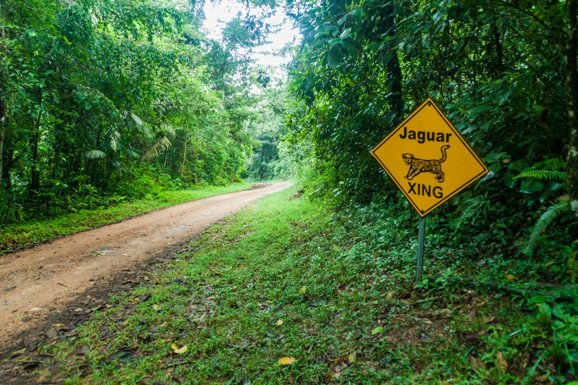
Tiger Fern Trail – Belize
Best for seeing jaguars
5.5km (3.4 miles), 3-5 hours, moderate
If you can peel yourself away from the sugar sands of Belize's cays and atolls, a wonderland of biodiversity awaits inland. Chief among the many reserves is the Cockscomb Basin Wildlife Sanctuary, which is precisely where you'll find this moderately challenging out-and-back route weaving through primeval jungles.
The Tiger Fern Trail creeps through dense thickets of Belizean pine and broadleaves, occasionally cutting across a babbling creek on moss-caked rocks. It takes you deep into jaguar-conservation territory, so keep those eyes and ears peeled for big cats as you go.
Nearing the top, there's a rustic campground with sweeping views of the Maya Mountains, along with a duo of waterfalls where you can cool off. The best time to come is the dry season (December to April), when the trails are generally less muddy and the plunge pools much clearer.
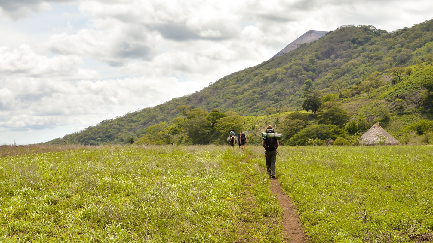
Volcán Telica – Nicaragua
Best for peering into the center of the planet
13.1km (8.2 miles), 1-2 days, moderate
You can climb Volcán Telica in León, northern Nicaragua, in either one or two days. It's not a terribly challenging route, starting with flat farm fields and then a steep push up the sinewy cone itself.
It's really all about the view at the top. Looking out, you'll see a sort of Nicaraguan Serengeti, sweeping west toward the Pacific in endless scrub fields dotted with the occasional mango tree, heat haze sitting low in the valley bottom.
But it's the view into the crater you'll write home about. Peer down to see a smoke-belching hole, plumed in sulfur and wisps of ash. At night – and here's the reason you might prefer to spend an evening on the slopes – it even burns red with hot magma and lava.
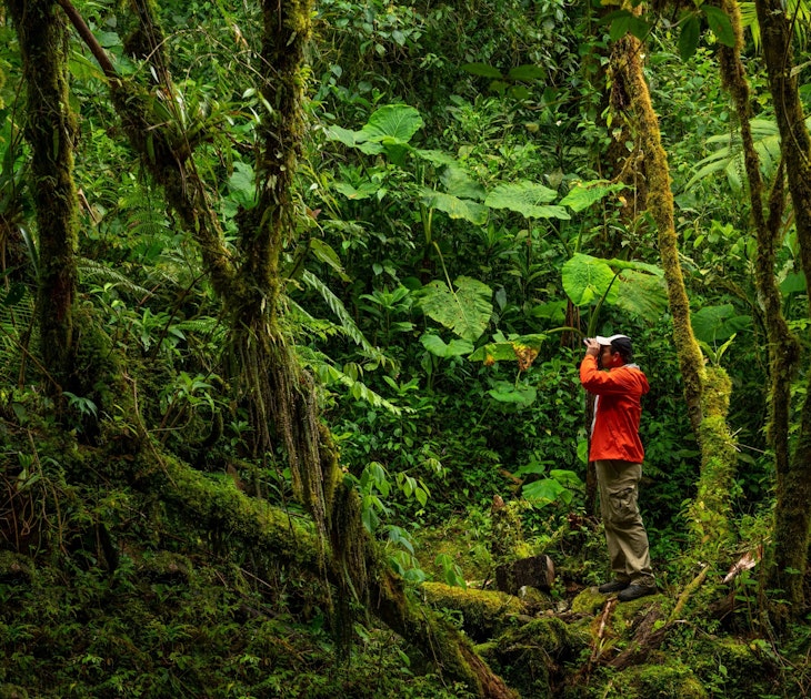
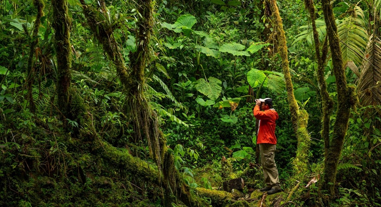
Pipeline Trail – Panama
Best for getting close to the jungles
6.1 km (3.8 miles), 2.5-3 hours, moderate
The Pipeline Trail is a straight valley walk through the Bajo Mono, the hiking playground just north of Boquete town in the heart of western Panama. It's actually named for the industrial pipe that joins the path at the trailhead, but it could just as well be for the closeness of the rainforest, which looms in like a tunnel as you really get going.
Yep, it's jungle on all sides here. A symphony of emeralds and greens rises overhead to the canopy, the scent of decaying leaves abounds and you get a sense of snakes moving in the undergrowth. Suddenly, you'll be stunned by the appearance of the great Cenizo – a hulking tree that's said to be over a millennium old. The finale is a ribbon-like waterfall that drops through a gap in the jungle-covered ridges above.
You might also like:
The best Mayan sites in Central America: Pyramids of power
The 14 best beaches in Central America
15 things you absolutely must do in Central America
8 of the best places to surf in Central America for beginners to pros