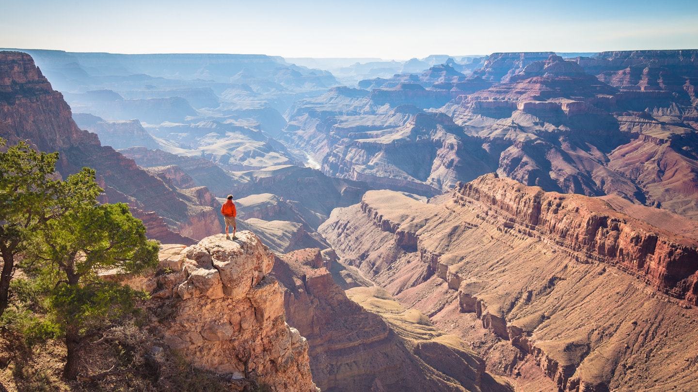
With a nickname like the Grand Canyon State, you can bet that Arizona boasts some incredible landscapes.
In addition to that crown jewel, it's also home to the Tonto Rim (which inspired Western writers like Zane Gray), Palm Canyon's rare stands of native trees, ancient lava flows, spectacular slickrock, and the brilliant turquoise of Havasu Falls.
Laced through all that rugged terrain are an array of trails for every hiker. From ADA accessible loops with unbeatable views to truly challenging treks that test the hardiest of outdoor athletes, from desert switchbacks strewn with petroglyphs to urban jaunts you can tackle with a to-go coffee in hand, there's a little something for everyone.
If you're wondering how to make the most of your time in the Grand Canyon State, these are the seventeen best hiking destinations in Arizona.
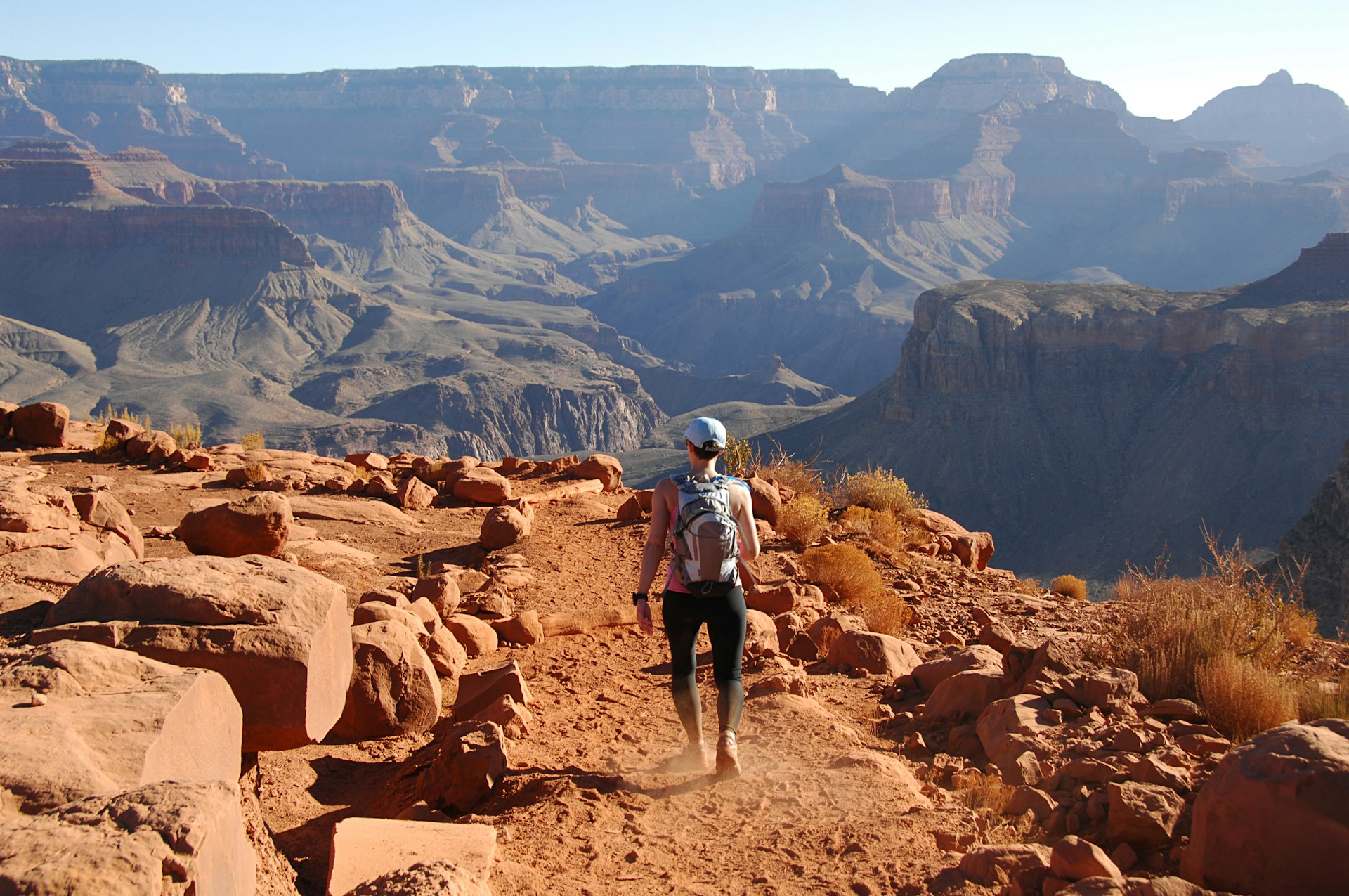
Bright Angel Trail
Best hike for exploring the Grand Canyon
Up to 12 miles, Difficult
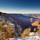
The most popular and accessible of the Grand Canyon corridor trails is the beautiful Bright Angel Trail, a spectacularly scenic 7.8-mile descent to the Colorado River with several logical day-hike destinations. Though steep, long stretches wind down without precarious drops along the edge, making this an excellent choice for families.
Summer heat can be crippling; day hikers should turn around at one of the two rest houses (3- or 6-mile round-trip) or hit the trail at dawn to safely make the longer hikes to Indian Garden and Plateau Point (9- and 12-mile round-trip, respectively). Overnight hikers can secure a backcountry permit in advance to camp at Indian Garden, about halfway down and one of the park's three developed inner-canyon campgrounds. Do not hike to the river in one day.
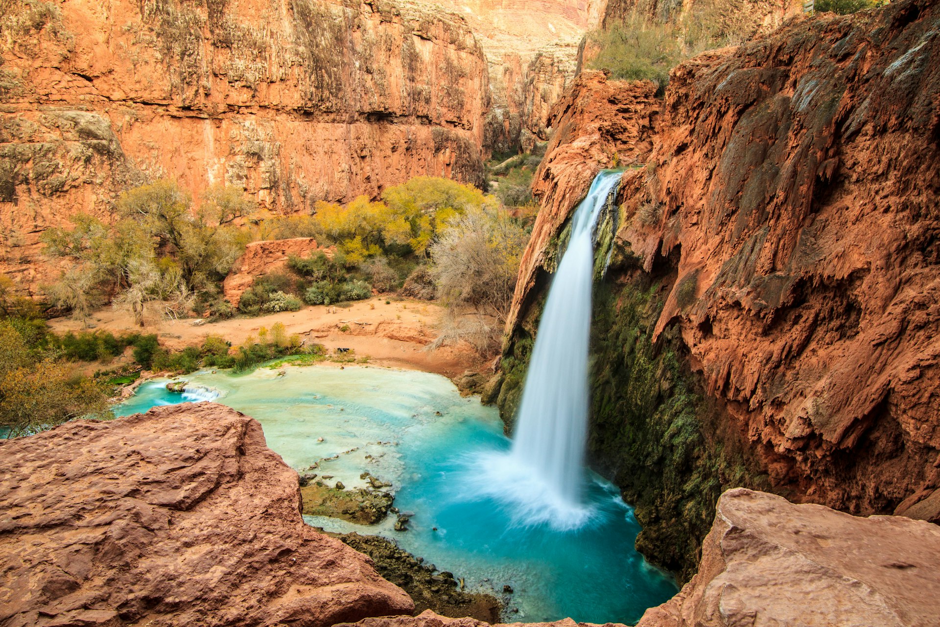
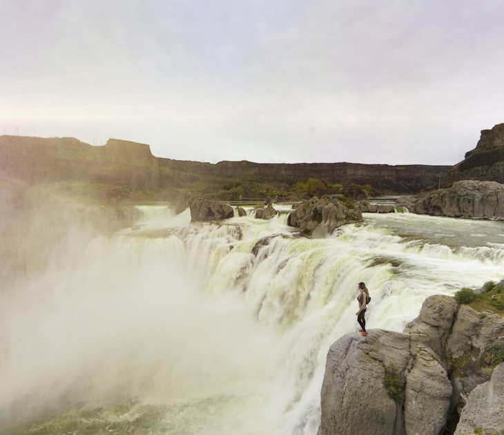
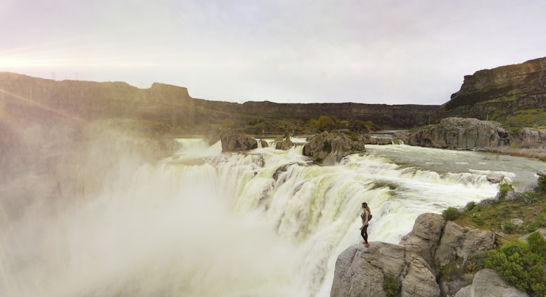
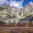
Havasu Canyon
Best hike for seeing waterfalls
20 miles, Difficult
Havasu Creek tumbles through the Grand Canyon on its way to the Colorado River, creating a series of waterfalls and swimming pools about 10 miles below the rim on the Havasupai Reservation. Note that rain and floods can affect the flow of and access to the falls, and getting to them can be tricky; the only access is via foot, mule or helicopter, and trails can involve multiple river-crossings and ropes.
Editor's note: due to the COVID-19 pandemic, the Havasupai Indian Reservation is closed to tourism, and this hike is inaccessible.
Cathedral Rock
Best hike for exploring vortexes
1.5 miles, Moderate
The Cathedral Rock vortex is a spectacular location for watching red-rock sunsets. You can ascend 550ft to a high saddle on a 1.5-mile trail (round trip), but you'll need to scramble up a steep rock face; it's not for those with vertigo or wearing flip-flops. Limited parking.

North Kaibab Trail
Best for a challenging hike
14 miles, Difficult
The North Rim's most accessible inner-canyon trek features strenuous switchbacks, raging waterfalls, a cottonwood-fringed campground and long creekside stretches. It takes a few days to complete – depending on how you pace it – but the first few miles also make for popular day hikes for those wanting a peek inside the canyon.
Pine Creek Trail
Best for seeing natural stone bridges
1 mile, Moderate
The fabulous natural formation known as Tonto Bridge was formed over countless centuries of attrition as Pine Creek scoured through a massive dam of calcium carbonate. Some 183ft high and spanning a 150ft-wide canyon, the resulting travertine bridge is thought to be the world's largest and is the centerpiece of a thickly wooded state park with splendid walking trails. One of the best is the Pine Creek Trail, a strenuous one-mile loop with 229ft of elevation gain.
Thunder River Trail
Best for multi-day treks
21.5 miles; Difficult
The crown jewel of Grand Canyon North Rim backpacking is a hot, miserable trail connecting an embarrassment of waterfalls, swimming holes and slot canyons. By combining Thunder River and Tapeats Creek trails with a 3-mile scramble along the Colorado River to Deer Creek, you create an epic adventure that highlights everything we love about the Grand Canyon – including the profound suffering.
West Fork Trail
Best for swimming holes and fall colors
6.5 miles; Moderate
This deservedly popular trail crosses Oak Creek a dozen times as it winds through the canyon, where walls soar more than 200ft in some places. The trail is marked for the first 3 miles, but you can scramble along the stream bed as far as 14 miles upstream. Parking is limited: arrive before 8:30am.
Most people head straight into the canyon, but if you cut over to the creek within the first 50ft, just beyond the parking lot, you'll find a particularly nice, sunny stretch with a swimming hole and shallow waters for splashing. It's an excellent hike for fall colors. It's located 9.5 miles north of Sedona (a few miles north of Slide Rock State Park) and 17.5 miles south of Flagstaff on Hwy 89A; look for the signed parking lot.
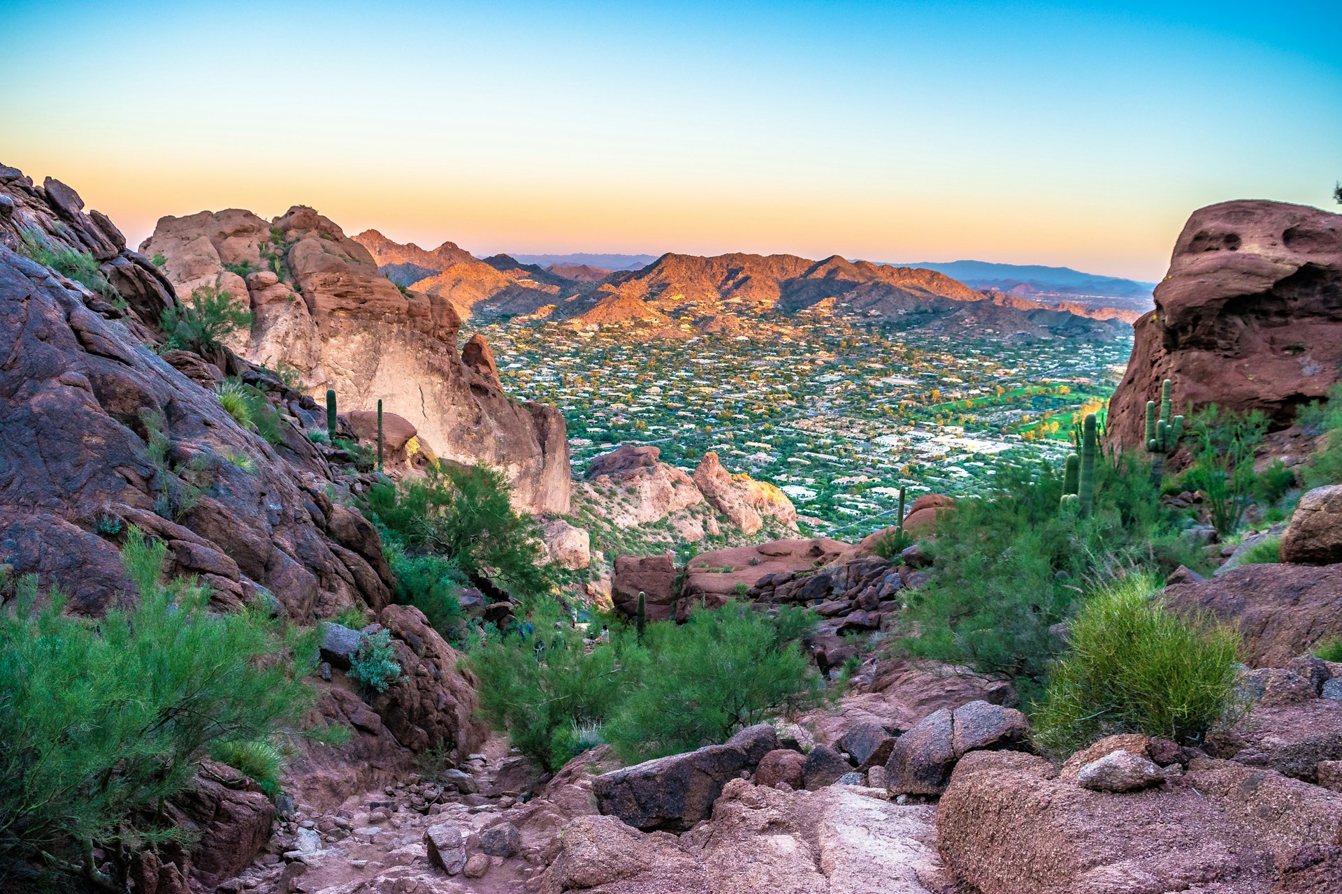
Camelback Mountain
Best for a punishing climb and stellar views
Distance varies; Difficult
This 2704ft twin-humped mountain sits smack in the center of the Phoenix action. The two trails, the Cholla Trail (6131 E Cholla Lane) and the Echo Canyon Trail (4925 E McDonald Dr), are short but steep, with 1264ft of elevation gain over a mere 1.2 miles and lots of hands-on scrambling over boulders. A great workout followed by stellar views.
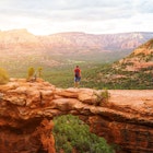
Boynton Canyon
Best for rock formations and vortexes
6 miles; Moderate
Gorgeous Boynton Canyon includes shaded stretches, petroglyphs and Sinagua ruins. During the relatively easy 6-mile hike (round trip), look for the rock formation known as Kachina Woman and try not to be moved. This is one of the area's four major vortexes. Limited parking.
From Sedona, head a couple of miles west on Highway 89A to Dry Creek Rd; turn north and follow signs to Boynton Canyon and Enchantment Resort.

Widforss Trail
Best for forest hiking
5 miles; Moderate
Meandering through shady forests of mixed conifer, old-growth ponderosa pine and quaking aspen punctuated by carpets of lupine, the Widforss Trail rolls past the head of The Transept and out to Widforss Point. Although it's a relatively popular day hike, people disperse quickly, and you likely won’t see more than a few other explorers. Numbered interpretive signs provide some depth to your stroll, while the dramatic viewpoint at the end provides an ideal place to have a picnic.
Palm Canyon
Best for unique flora
1 mile; Easy
A great spot to explore the desert north of Yuma, Palm Canyon is the home of Arizona's only native fan palm trees. The palms – possible descendants from trees growing here during the last Ice Age – are hidden halfway up the side of a shady canyon in the Kofa National Wildlife Refuge. It's a 1-mile hike round-trip.
Bring binoculars, or, if you're a scrambler, climb all the way up from the viewpoint until you reach the grove. While exploring the refuge, keep an eye out for bighorn sheep, pronghorn antelope, desert tortoises, vultures and, of course, snakes. Winter and spring are the best times to visit. Free dispersed camping is allowed on the refuge.
To get here, turn east on Palm Canyon Rd near mile marker 85 off Highway 95; it's about 65 miles north of Yuma and 60 miles south of Parker. Follow the dirt road (passable in a regular car) 7 miles through the desert until you reach the mountains, where the trailhead is located.
South Kaibab Trail
Best for view of the Grand Canyon
Distance varies; Difficult
The maintained South Kaibab is one of the park's prettiest trails, combining stunning scenery and unobstructed 360-degree views with every step. Steep, rough and wholly exposed, this ridgeline descent plummets 4470ft along 6.4 miles to the Colorado River; from here, it is 0.5 miles to Bright Angel Campground. Rangers warn against all but the shortest day hikes during the summer.
The shortest is 0.9 miles to Ooh Aah Point, a popular marked turnaround, but if you continue just a few minutes more, you'll find a fantastic wide and flat stone outcrop that makes a perfect spot to relax with a snack before tackling the return trek to the rim. For a longer day hike, head to Cedar Ridge, 1.5 miles from the rim, a large, flat, red dirt expanse with pit toilets, or to Skeleton Point, 3 miles from the rim. Expansive cliff-top views include the Bright Angel Trail and a wide swath of the Colorado River.
East Rim View
Best for accessible overlooks
Distance varies; Easy
With views east into the Saddle Mountain Wilderness, Marble Canyon and the Vermilion Cliffs, this easily accessible overlook (elevation 8810ft) is suitable for strollers and wheelchairs. In fact, it’s so easy to reach, it’s amazing there aren’t more people out here. East Rim doesn’t offer the inviting views, picnic and camping opportunities of Marble View, but it’s a beautiful spot. From the overlook you can hike the East Rim Trail 1.5 miles down and from there connect to longer hikes.
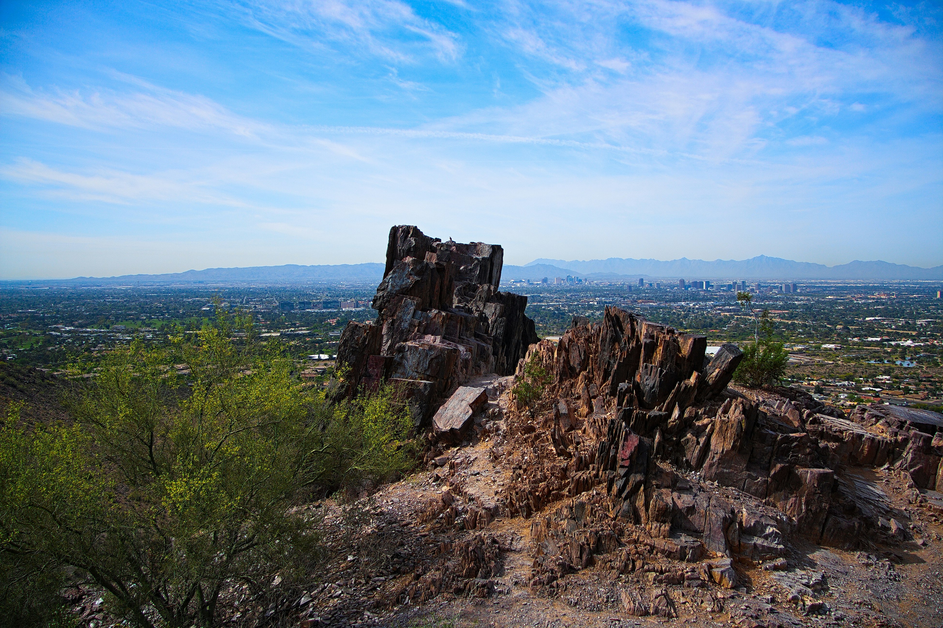
Piestewa Peak
Best for views of Phoenix
1.1 miles; Difficult
Dotted with saguaros, ocotillos and teddy bear cholla, this lovely summit was previously known as Squaw Peak. It was renamed for local American Indian soldier Lori Piestewa who was killed in Iraq in 2003. Be forewarned: the 1.1-mile trek to the 2608ft peak is very tough but hugely popular – the park can get jammed on winter weekends.
Parking lots northeast of Lincoln Dr between 22nd and 24th Sts fill early. The peak is bordered by two recreation areas, Phoenix Mountains (2701 E Squaw Peak), where the Summit Trail begins (dogs not allowed), and Dreamy Draw (2421 E Northern Ave).
Cathedral Wash
Best for canyoneering
3.3 miles; Difficult
Cathedral Wash is a splendid little canyoneering adventure that descends 1½ miles to the Colorado River. Two dry falls must be bypassed as you make your way down the wash (go right both times). Casual hikers may want to turn around at the first as good scrambling, and route-finding skills are essential. Expect to get your feet wet.
The Lava Flow Trail
Best for seeing ancient volcanic action
1 mile; Easy
Around 1064 CE a cinder cone erupted in what is now Sunset Crater National Monument, spewing ash across 800 square miles, spawning the Kana-A lava flow. Now the 8029ft Sunset Crater is quiet, and short trails wind through the Bonito lava flow (formed c 1180) and up Lenox Crater (7024ft). The Lava Flow Trail is a loop less than a mile long, but it boasts splendid views of the cinder cone and lava rocks.
Secret Slickrock Trail
Best for photographers
.7 miles; Easy
Photographers, this one's for you. Come here at sunset to capture Sedona's Cathedral Rock reflected in the sandstone pools atop this lovely mesa. It's best after a recent storm. Otherwise, the pools may be dry.
You may also like:
The best of Arizona beyond the Grand Canyon
A descent into the Grand Canyon in the low season
Making waves: the American Southwest’s best river trips