In Norway, mountains spring straight from the sea and mossy greens sit starkly against grey, craggy, snow-capped peaks. The best way to take it all in? Behind the wheel of a car.
A drive around the scenery of country is, quite simply, an otherworldly experience. From island-hopping, bridge-crossing coastal drives to hair-raising mountain passes, take your time to explore Norway at its very best with these top road-trip routes.
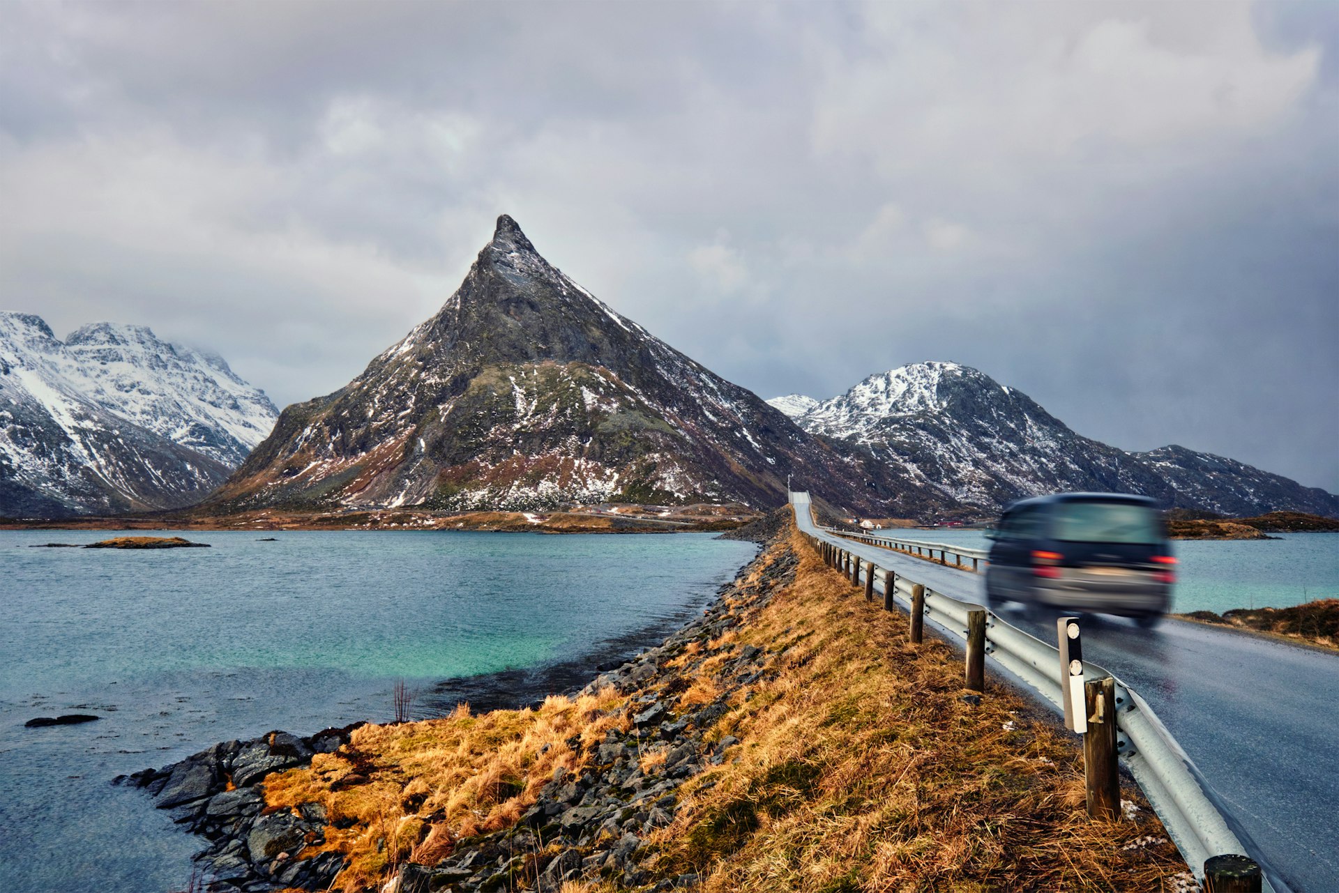
1. The Lofoten Road
Best road trip for heading off the beaten track
Svolvær airport to Å; 133km (83 miles)
For those looking for something adventurous, remote and, well, arctic, try the road that connects the islands of Lofoten, a wild archipelago that clings to the coast and sits inside the Arctic Circle. Far from the beaten track of tourist sites within striking distance of Oslo, Bergen and Trondheim, the Lofoten lies in the far north of the country, which makes it the ideal place to see birdlife and the northern lights in the wintertime. This trip takes you along the E10 all the way to its end in the tiny fishing village of Å, on the far west of the archipelago.
With just one road to follow as it snakes its way across the islands, there’s very little chance of getting lost. But don’t rush: the whole drive can be done in under three hours, or you could take a few days to soak in all there is to see. As the road hugs the coast, you’ll be treated to stunning views of mountains rising steeply from the sea, turquoise waters and – depending on the time of year – plenty of snow in winter or lush greenery and blonde beaches in summer. Despite lying within the Arctic Circle, the climate is surprisingly mild thanks to the Gulf Stream.
Along the way lie a few essential sights. First on the route from Svolvær airport is the viewpoint at Torvdalshlsen, with its modern benches providing shelter as you look over Vestvågøy. From there, keen twitchers should head over to the west side of the area to the lakes of Gårdsvatnet, Skjærpvatnet and Storeidvatnet to see the best winged wildlife the region has to offer.
Staying within Vestvågøy, it’s on to Eggum and its amphitheater-shaped rest area that offers views down the rugged coastline on one side and towering, jagged mountains on the other. An hour further west toward the end of the road is Rambergstranda, which features an idyllic beach in Jusnesvika bay. The site is an unusual blend of peaks, sand and azure seas, with a walkway made of railway sleepers enticing you down to the water’s edge.
From Rambergstranda, it’s a 40-minute drive to the village of Å, where the road quite literally ends. This tiny village was dependent on fishing until the 1990s, when tourism started to take over. As one of the most westerly points in the country, the village is a beautifully isolated outpost, whose red wooden fishing huts hark back to a time when tourists would seldom venture this far.
Planning tip: Fly directly to Svolvær airport on the island closest to the mainland, which serves as the gateway for the Lofoten road. Luckily, you’ll find a rental-car company at the airport, which saves a lengthy drive through Norway to get to the starting point.
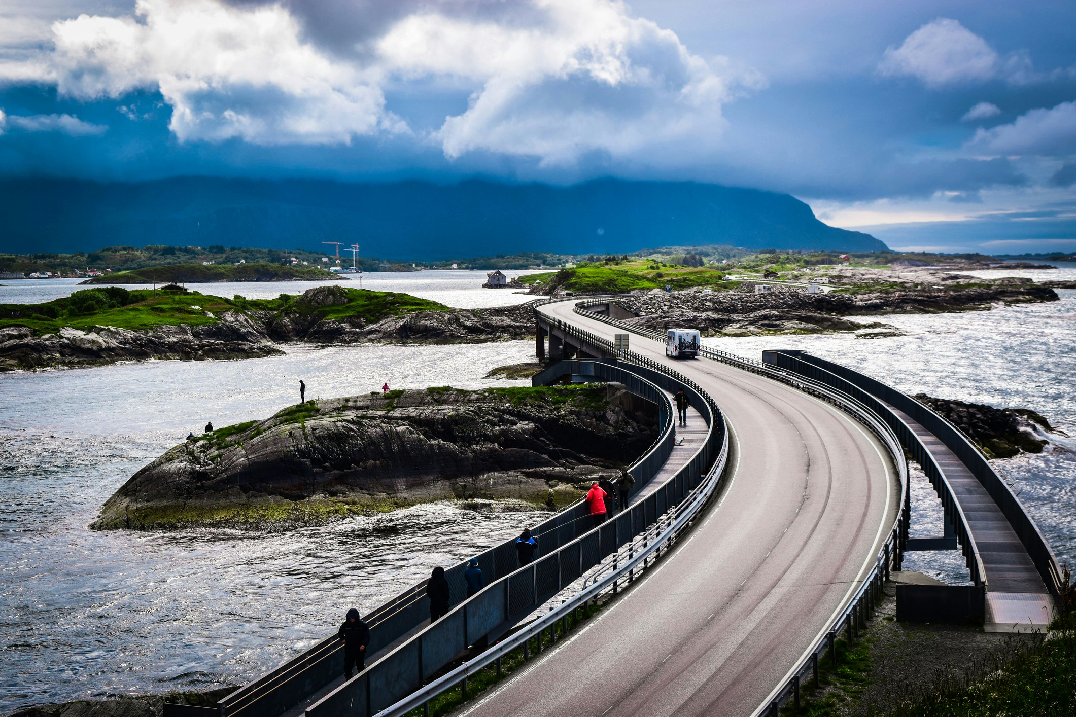
2. The Atlantic Road
Best road trip for bridges
Molde to the Gjemnessundbrua suspension bridge; 111km (69 miles)
A frequent feature of Norway’s road network, bridges and tunnels keep many of the country's 50,000 islands connected. For those looking to sample some of Norway’s most beautiful bridges, look no further than the Atlantic Road. Beginning not far from the city of Molde, the route has connected the island of Averøy with the mainland since 1989.
Best known as one of the filming locations for a driving scene in the 2021 Bond film No Time to Die, the route has a total of eight bridges that stretch over 8274m (27,146ft) along the route, giving way to some spectacular views across the Atlantic.
Start by driving north from Molde on the E39 before taking the exit for Rte 64 – and get ready for coastal scenery, culture and history. From here, there’s no need to take any turns as the route guides you up to the coastline. The breeze from the Atlantic and the bridges signify the start of the drive.
Once you’ve crossed the Storseisundbrua – the road’s longest and best-known bridge – hopping from one inlet and island to the next can be quite the experience on a blustery day. With the ocean foam peppering the road as you drive along, the initial stretch is magically moody when a northwest storm rolls in. On a still summer’s day, it’s equally impressive – not to mention easier to stop and snap some spectacular photos.
After the main stretch of bridges, Rte 64 weaves its way across the island of Averøy before dropping down into the Atlantic Ocean Tunnel and resurfacing to join Rte 70. Once across the beautiful but sparsely populated island of Frei, the road drops down into another impossibly long tunnel that reconnects with the island of Bergsøya briefly before heading across the mighty Gjemnessundbrua suspension bridge. First opened in 1992, the bridge reconnects to the mainland, where the route continues on Rte 39 back to the city of Molde.
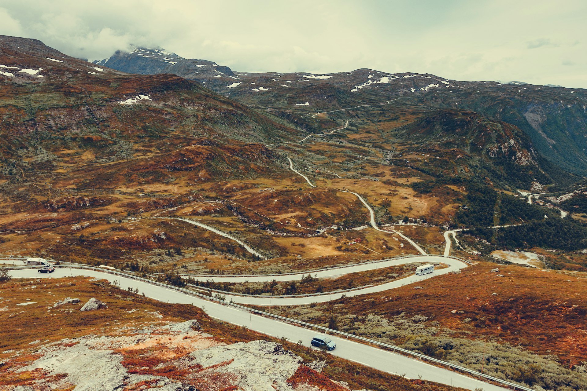
3. Sognefjellet
Best road trip for an inland adventure
Lom to Gaupne; 108km (67 miles)
Moving away from the coastline, the Sognefjellet is a road that cuts through the heart of the Bøverdalen valley. Expect constantly changing scenery as this route climbs up to a high point of 1432m (4705ft), making it northern Europe’s highest mountain pass. Given this, part of the route – from Rustasætre/Vegaskjelet to Turtagrø – is usually open from spring until autumn, closing for the winter months. Those traveling shortly after it reopens in the spring will be treated to 3m (10ft) banks of snow lining the road on both sides, illustrating the full force of a Norwegian winter.
Once an important transport artery linking the coast and inland areas, the Sognefjellet was used to carry salt and fish eastward, while butter, pitch and leather were transported west. Now a popular tourist trail, the route has many viewing platforms and spectacular natural features that tempt you off the beaten track.
Start in Lom, a small village that has built up a reputation as a culinary capital (make sure you sample the local delicacies before heading off). Halfway along the route, a rugged stone sculpture at Mefjellet by Knut Wold is a firm favorite with photographers, as it frames the jagged mountain landscape surrounding it.
Closer to Gaupne, the route continues along the shores of Sognefjord from Skjolden toward its end. The largest and deepest fjord in the country, Sognefjord is called “King of the Fjords,” and cuts a 205km (127-mile) course through the heart of Norway. Once around the glimmering green and blue waters of Sognefjord, the route ends up in the small village of Gaupne, where a traditional wooden church overlooks the water.
Planning tip: Gaupne is the perfect place to stop off before doubling back to drive the route in reverse, or continue southwest along the shores of Sognefjord.
4. Scenic Route Jæren
Best road trip to discover Norway’s spectacular south coast
Ogna to Bore; 41km (25 miles)
While the Jæren road between Ogna and Bore itself is not particularly inspiring, it offers the best way to take in the most beautiful parts of Norway’s southern coastline.
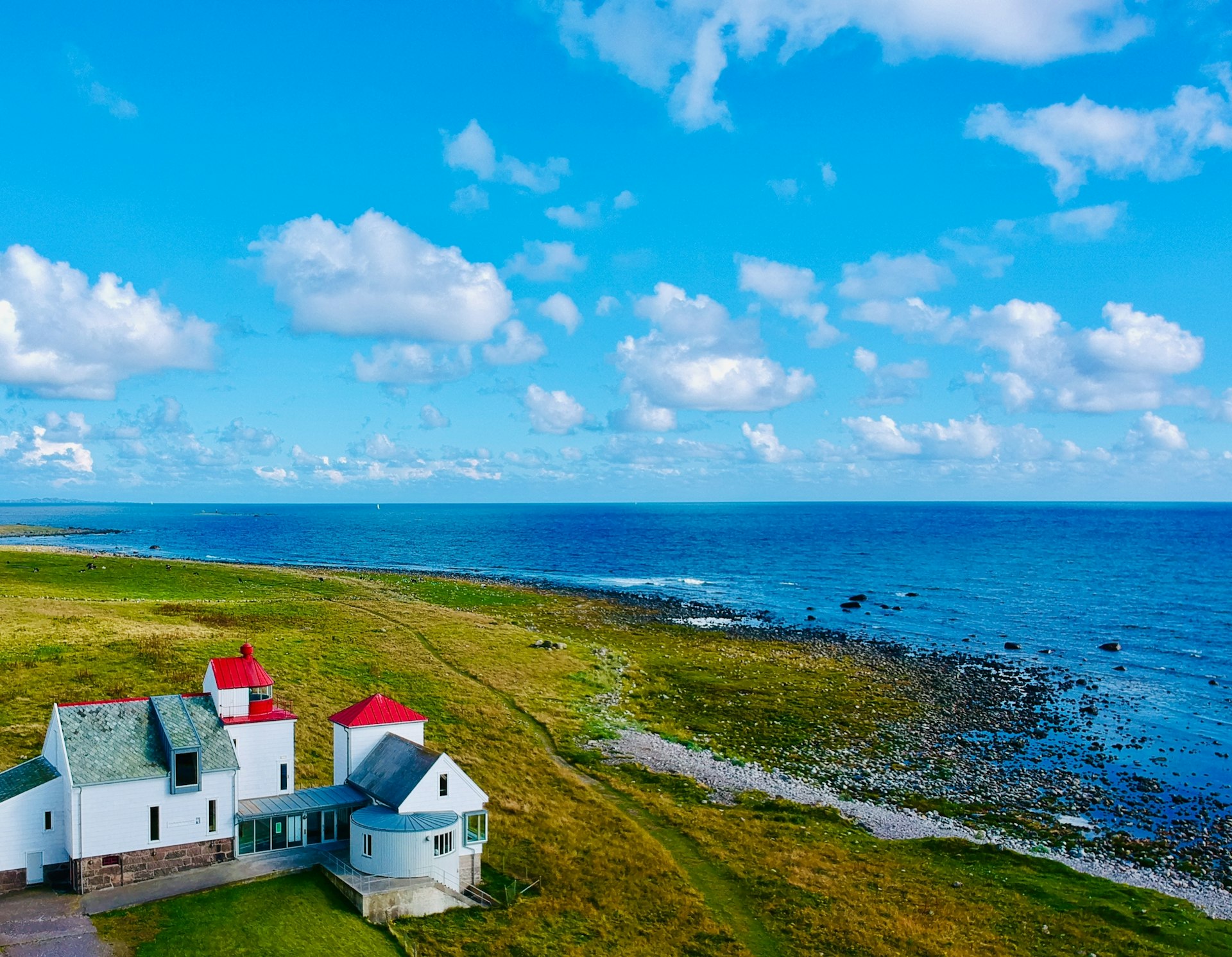
Starting out in the small village of Ogna, pick up Rte 44 as it heads northwest, hugging the coastline all the way. Less than 10km (6 miles) from Ogna lies the Kvassheim lighthouse, well worth a visit. On a coastline littered with shipwrecks, lighthouses are a frequent sight; Kvassheim is one of the best examples. First built in 1912, the lighthouse was still in operation until 1990, when a smaller, automated beacon replaced it. Today, the wooden building houses a museum and visitor center.
From Kvassheim, the route continues northwest on Rte 44 before breaking off to pick up Rte 507, which runs parallel to the white sands of Orrestranda, one of the best beaches in Norway. Here you can walk for miles along the sand, while taking in the rich flora and fauna that surround the beach and populate the sand dunes. Finishing up, it’s a short drive to the village of Bore, where the route comes to an end.
Planning tip: Take your time on this journey: there are plenty of stunning hidden spots and detours to take in along the way.
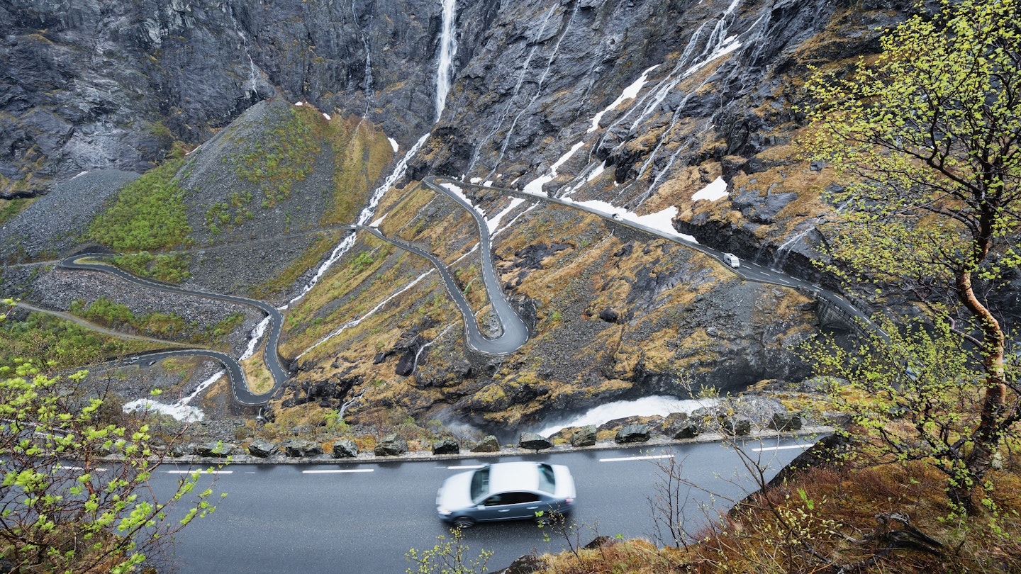
5. Trollstigen pass
Best road trip for thrill seekers and photographers
Åndalsnes to the Trollstigen visitor center; 40km (25 miles)
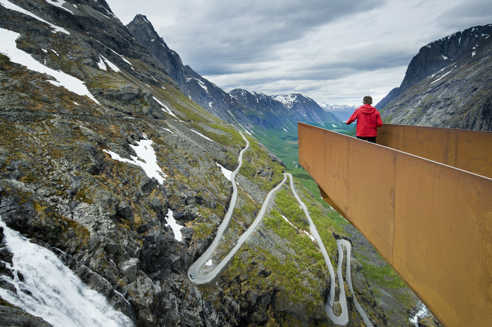
The Trollstigen pass (the Troll Path) is one of the world’s most celebrated roads – with good reason. (You might recognize the drive from the final season of Succession.) Made up of 11 bracing hairpin bends that carry the road up more than 850m (2790ft) up the mountainside, the route links Åndalsnes with the Valldal valley and Geiranger. Replacing a challenging hiking trail, the pass scales a sheer face dominated by the Stigfossen waterfall – a vigorous body of water that cascades off the mountain and plunges more than 350m (1000ft) in a thundering torrent.
Starting in the small town of Åndalsnes, take Rte 64 south out of the town for a short distance before making a left turn to join route E136. Head along here until the turn for Rte 63 comes up on the right, then head off south. After roughly 20 minutes of driving, the imposing sheer face of the Trollstigen will come into view, which is where the route starts to twist its way skywards. There’s a small rest area at the bottom, which makes for an ideal, low-down shot of the pass before the climb begins.
Once on the pass, your eyes might want to wander to the views down the valley out of the side window – but resist the temptation to look away from the tarmac, as it snakes its way up the mountainside with the rugged edge of the cliff face on one side and a hefty drop down on the other side. (Luckily, there’s a sturdy concrete barrier that lines the road for most of the way.)
As if the views weren’t enough, there's another surprise at the Trollstigen’s summit. With its modern steel-and-concrete aesthetic, the Trollstigen visitor center and cafe is an ideal stopping point to catch your breath and take it all in.
Best of all is a zig-zagging pathway that starts from the summit and leads to viewing platforms perched high above the pass. The structure is an impressive architectural feat – and also the key to securing the final piece in the photographic puzzle for those documenting the drive. From up here, the views on a clear day are simply sublime.
Planning tip: Harsh weather and snow make the route impassable to traffic between October and May. The road reopens after the annual spring rockfall, which legend has it results from trolls fighting on the nearby Trollveggen mountain. For those looking for that epic shot of a steep-sided Norwegian fjord, Trollstigen is the one.