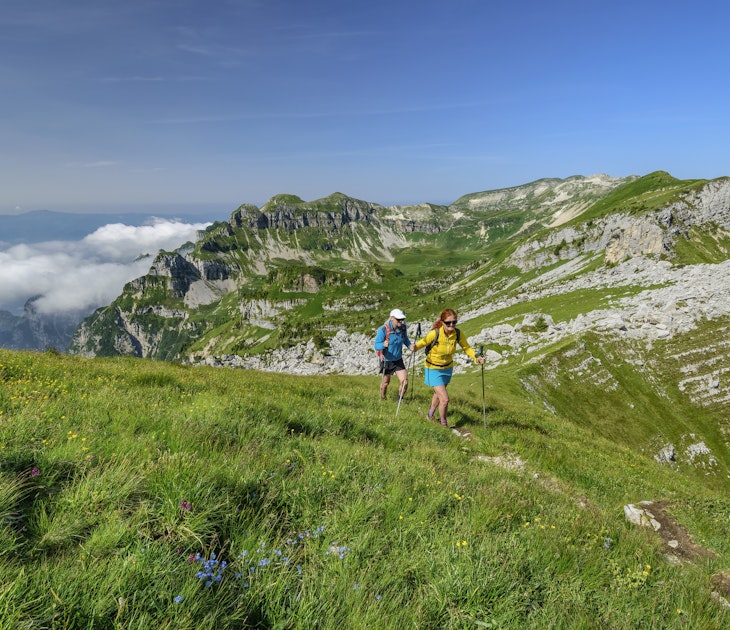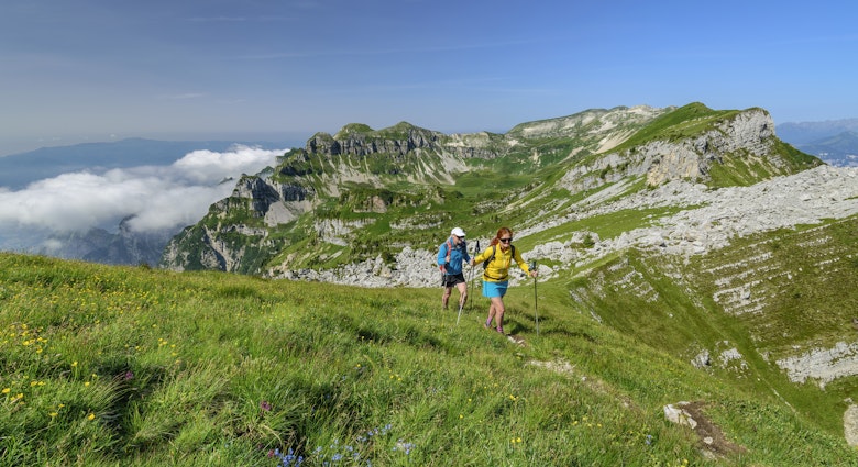
You can swoon over views from road-trip lookouts, but nothing beats whacking on hiking boots and hitting the trekking paths for a taste of Tenerife way beyond the tourist trail. Only when you strike out on foot can you even begin to appreciate how utterly wild this island really is.
With a mellow year-round climate and an insane amount of biodiversity packed into a small space, Tenerife deserves to be better feted for its out-of-this-world hiking. Clamber along cliffs on the savagely beautiful coast, with the Atlantic booming below, slip through subtropical terraces stippled with banana trees and palms, tread softly through primeval laurel forests, and rise at the crack of dawn to climb a volcano above a lavascape that looks like Mars – then you’ll feel the island’s true wonder.
The best part? It’s all marvelously accessible, with trails easily reached by bus and car, and many suitable for kids. At the end of a sweaty day, you can swim in a bay to cool off, with a plate of fresh seafood and cold cerveza waiting for you on shore.
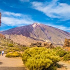
Pico del Teide is the highest hike with out-of-this-world views
8.3km (5.2 miles) from Montaña Blanca–La Rambleta, 5-6 hours, challenging
This hike is the big one: a rough, tough, but massively rewarding ascent to Spain’s highest peak and a volcano to top them all: 3715m (12,188ft) Pico del Teide. Often emerging above a blanket of clouds, the crater has top-of-the-beanstalk views across the lunar valley below, pockmarked with cañadas (depressions), and far beyond to the islands of La Gomera, La Palma and El Hierro, which shimmer across the Atlantic.
Starting at the foot of Montaña Blanca, the trail eases you in gently on a path traversing lava and pumice, but don’t be fooled. Before you know it, you’ll be on Teide’s dark slopes and hoofing it up a breathtakingly steep ridge to the 3270m (10,728ft) Refugio de Altavista, where stargazers and those wanting to glimpse the summit at sunrise bed down for the night. Grab a drink and enjoy a packed picnic before continuing over tongues of lava to the upper cable car station, where the views crack open.
Providing you’ve got a permit, you can continue to the crater for even more staggering views. Or content yourself with the views from Mirador de La Fortaleza lookout point (3537m) at the upper cable car station. From here you can take in the rust-red ridges of La Fortaleza, which fling up like natural fortifications, the Huevos del Teide (“Teide Eggs”), enormous boulders of magma – technically accretion balls – that rolled down the mountainside when the volcano erupted, and much of the island’s north. From here, your poor, tired legs will welcome the cable car down. The base station is 3km from the trailhead.
Spring and fall are perfect times for this highly memorable climb because you’ll dodge the winter snow and summer heat and get to see the landscape at its least crowded and most photogenic, with crisp light, wildflowers and perhaps a light dusting of snow. Good weather is essential if you want views. Just 200 permits are issued per day, so if you want to tackle the peak in the high season, you’ll need to plan months ahead. Alternatively, if you would prefer some company and don’t want to do the paperwork, join a guided hike.
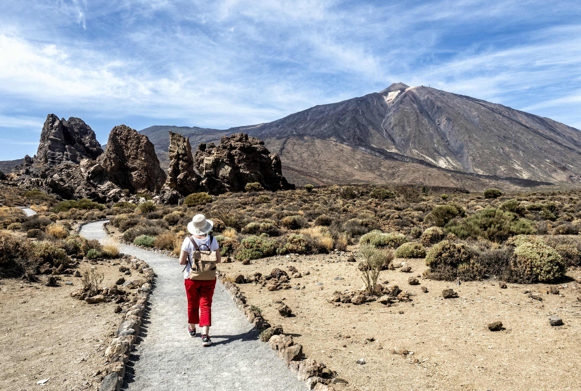
Roques de García Trail is the easiest walk, perfect for families
3.5km (2.2 miles) round trip, 2 hours, easy
Save climbing Teide for another day – if you want the full-on explosive drama of the national park without the uphill slog, Roques de García chucks you in at the geological deep end. Nature threw out the rulebook here, with bizarrely twisted, buckled and contorted lava pinnacles flinging up from the rust-red, desert-like landscape. Yes, it’s popular, with buses disgorging day-trippers at the trailhead parking lot at Mirador de la Ruleta, but most visitors go no farther than the viewpoint. This circular trail is a quieter way to glimpse the solidified streams of magma and spectacularly eroded volcanic dykes.
Doable for families with small kids, this trail delivers maximum wow for minimum effort. Arrive early before the parking lot gets full and bring sturdy shoes and warm layers. If you want to see the area at its most peaceful, hike at sunset, when the shadows deepen and the landscape is bathed in golden light, or on a bright moonlit night.
The trail is initially flat and gentle as it heads down to the sedimentary Ucanca plains, but it picks up pace and steepens toward the end. Keep your camera handy for rock stars like the twisting Roque Cinchado, nicknamed the “Stone Tree” or “Finger of God,” so iconic it featured on Spain’s old 1000 peseta note. Other attention grabbers include the waterfall-like lava tongue of La Cascada and cathedral-shaped phonolitic chimney La Catedral. If you see a flash of blue among the rocks, it might be a Gallot’s lizard, which is endemic to the Canaries.
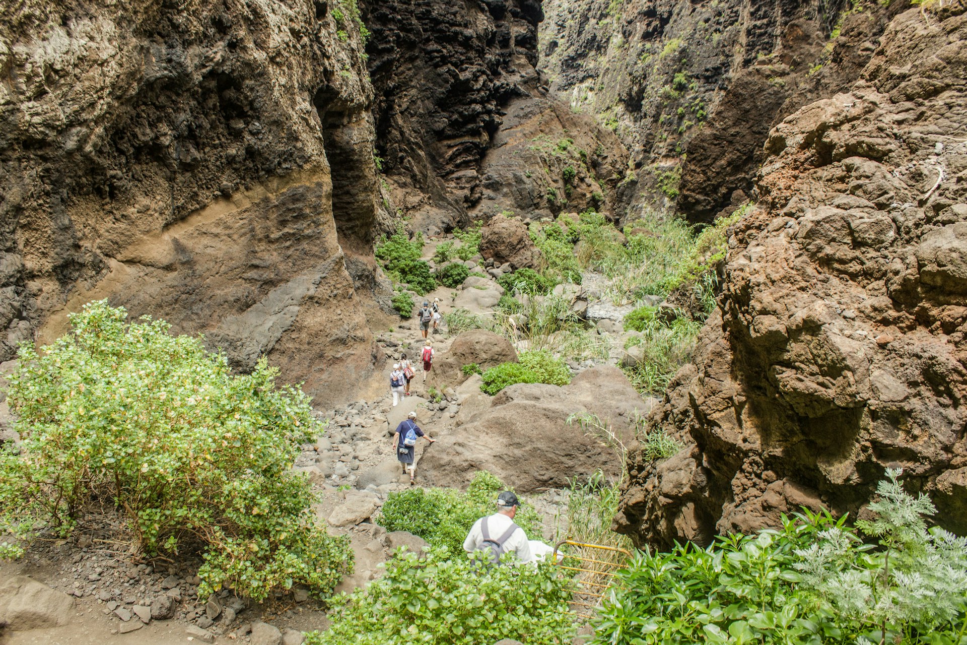
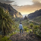
Barranco de Masca is Tenerife's greatest gorge hike
10km (6.2 miles) round-trip, 6 hours, moderate to challenging
Clinging aerie-like to a mountaintop and rimmed by shaggy peaks and great fists of rock, the tiny hamlet of Masca looks as though it would blow away with just a puff of breath. Following a road that helter-skelters ever higher into the mountains, the drive here is quite something, but it pales by comparison to this hike, which drops you into Tenerife’s loveliest gorge, Barranco de Masca.
Heading over stream and orchard, with vertical walls of rock rising up on either side, the trail through the ravine to the ocean is rugged, challenging and one for good weather only. Rockfall and landslides can be a real risk, but it’s worth it: your reward at the end is the chance to leap gleefully into the exquisite turquoise water of a cliff-wrapped bay.
The round-trip hike takes around six hours, or you can walk one way and catch the ferry back to Los Gigantes. If you don’t feel confident walking alone or would prefer to go with a group, enlist a guide like El Cardón.
Rambla del Castro is the best coastal hike
8.6km (5.3 miles) round trip, 2¼ hours, easy
All is sea and sky on this cliff-hugging hike in the island’s north, weaving along the coast from Hotel Maritim in Puerto de la Cruz to Mirador de San Pedro. The crashing Atlantic is your constant companion as you pick your way along cobbled trails and dirt tracks that lead through banana plantations, palm groves and stone-walled terraces, and over ravines and cliffs, to wave-smashed bays where pirates once hid their booty.
For such a short walk (just over an hour one way), highlights are many and varied. Look out for the strikingly eroded rock formations, arches and caves of Playa de los Roques; the ruins of La Gordejuela, Tenerife’s first steam pump dating to 1903, which was originally used to irrigate the bananas; and the wild, black-sand crescent of La Fajana. You’ll also get to see Fortín de San Fernando, a little 18th-century fort built to ward off pirates; cliff-clasped, waterfall-splashed Playa de Castro (best at low tide); and the 16th-century hermitage of San Pedro with its baroque statue of the saint.

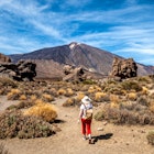
Pico Viejo is a permit-free volcano climb
9.3km (5.8 miles) from Mirador de Pico Viejo–Mirador de las Narices del Teide, 5 hours, challenging
Pico Viejo (“Old Peak”) plays second fiddle to its big brother, Pico del Teide, but clued-up hikers know that this far-less-crowded trek is just as compelling – and you don’t need a permit. Get an early start so you don’t have to rush and you can experience this Martian landscape in the hush of morning. This scene-stealer of a 3135m-high (10,285ft) volcano was the last on the island to properly blow its top in 1798, spewing magma high into the air. Torrents of swirling lava solidified on its slopes, and to this day, no vegetation grows here.
From La Rambleta at Teide’s upper cable car station, it’s an easy but staggering 30-minute ramble past sulfur-belching fumaroles and tongues of black lava to the trailhead at Pico Viejo viewpoint. Here you begin your walk on a high, with gasp-out-loud views of the mighty crater, measuring a whopping 800m (2624ft) in diameter, and beyond to the islands of La Gomera, El Hierro and La Palma. Take photos and a breather for summoning all your energy for Sendero (Trail 9).
It’s one heck of a descent, a relentless, strenuous and at times steep downhill scramble across rust-brown cinder scree on a barely defined trail. But it’s a beauty – walking on this arid peak towards the crater is like walking on the moon. The next rough and rugged section crosses pumice stone before skirting Pico del Viejo’s southern rim. The route then drops abruptly down to the two buried craters of Las Narices del Teide (“Teide’s Nostrils”) before reaching the TF-38 road at trail’s end.
Mil Ventanas de Güimar is a tough hike with cliff-hanger moments
13km (8.1 miles) round-trip, 4 hours, challenging
With a name like “Thousand Windows,” you’d expect this trek to be a knockout, and you’d be right, but it’s also a tough nut. You’ll gasp at the vertical walls of rock punching high above the void as you dangle on the edge of a breathtakingly sheer ridge, pulse racing. Tenerife’s east coast unfurls giddily below you as you burrow through the ventanas (windows), tunnels hacked out into the cliff face that were originally built as a means of transporting water from the mountains but never realized their purpose.
This hike isn’t for the unexperienced, faint-hearted or unsure of foot. The trailhead is near the parking lot at Antena de Comunicaciones, off the TF-28, which is reached via a steep, narrow road.
A sign at the start makes it blatantly obvious that you attempt this walk at your own risk. The trail is exposed, and rockfall can be a danger. Attempt it only in stable weather and bring plenty of water and a flashlight. Logistically, it is easier (if longer) to reach the eighth window and then backtrack to the start, rather than continuing on the rugged path to Güimar.
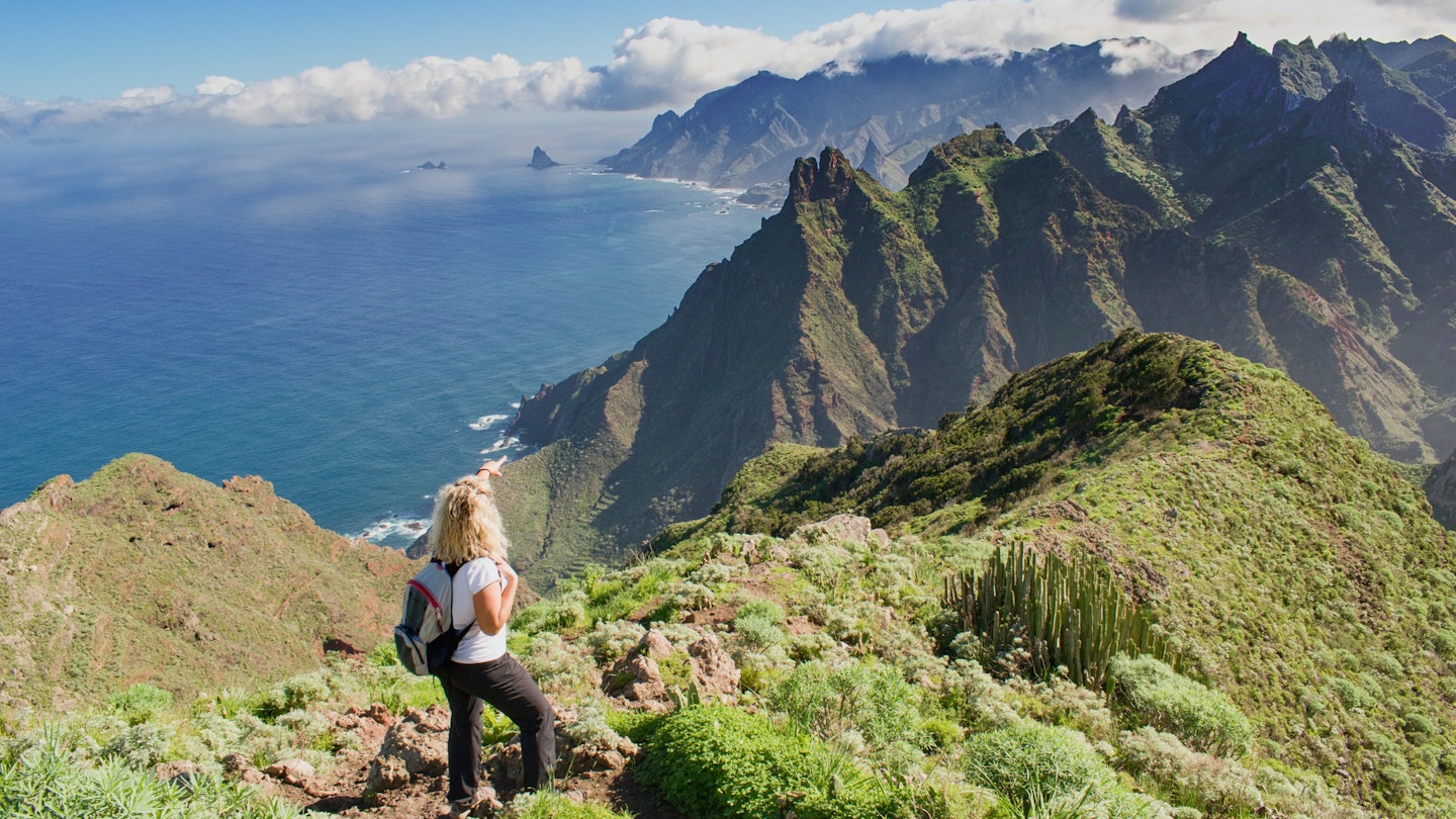
Anaga's Chamorga to Playa de Roque Bermejo is a hike through wild coastal beauty
8.7km (5.4 miles) round-trip, 4 hours, moderate
The Anaga Rural Park in Tenerife’s northeast is a wild, forgotten world, with Eden-like valleys, sculpted terraces echoing the contours of the mountains, jagged cliffs diving into the piercing blue Atlantic and mossy laurisilva (laurel) forests that look ripe for a Tolkien fantasy. This is the Tenerife you’ll wish someone had told you about sooner.
Make it this far, and you’ll want to tackle one of the many hiking trails that blaze through this Unesco Biosphere Reserve. A moderately challenging half-day loop takes you from the little mountain village of Chamorga along a peninsula that thrusts into the wave-whipped Atlantic. Much of it is ridge trail, so you’re almost constantly on a high, with the views deep into lush ravines, up to scaly mountains and out to sea becoming increasingly dramatic as you approach Faro de Anaga lighthouse.
At trail’s end, you can cool off over a drink in the tiny bar next to the chapel and go for a swim off the glinting dark sands of Playa de Roque Bermejo.
Mirador de Sámara is the hike with the best views of Mt Teide
5.1km (3.2 miles) round-trip, 2 hours, moderate
The best view of Mt Teide isn’t when you’re standing right on top of it, although the summit is one of the best places to get away from the crowds. Instead, the best views of Spain's highest peak are up this moderately challenging volcanic trail. Starting and ending at the Mirador de Sámara parking lot off the TF-38, the well-signed trail slithers through the ashen, softly undulating landscape of a perfect crater, with tephra (fragments of rock flung into the air by an erupting volcano) crunching underfoot. It’s quite steep at the beginning, but it soon flattens out and makes for fairly gentle walking.
The trail is at its most spectacular in late winter or early spring, when Teide is wearing its snow cap and the broom is in full golden bloom. At any time of year, you’ll get close ups of the Canarian pines that are endemic to the outer Canary Islands. Look and listen out for kestrels, Canarian chiffchaffs and Berthelot's pipits.