Utah’s national parks and state parks harbour some of the most extraordinary landforms on Earth, and embody the spirit of the American frontier. Explore with Lonely Planet Traveller magazine’s Rory Goulding. Images by Philip Lee Harvey.

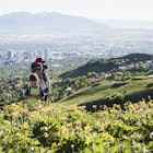
Antelope Island State Park
Roughly 11 islands are scattered around the shallow, briny expanse of the Great Basin in western Utah, although the exact number changes with the fluctuating water levels. The largest however is always Antelope Island and, at 15 miles long, it provides a spacious sanctuary for one of the biggest herds of American bison. These symbols of the western frontier, also called buffalo, once roamed the plains of North America in their millions, but with the westward expansion of European settlers, their population was hunted down to a few hundred by 1890.
The 600-odd bison on the island today are managed with more care, most visibly when they are rounded up in late October to be checked over and for a partial cull. The ‘antelopes’ that inspired the park’s name are actually slender, fleet-footed pronghorn.
Get there: from Salt Lake City, it’s about an hour by car north on I-15 to exit 332, then west across the causeway to Antelope Island.
Arches National Park
Few natural phenomena look quite as unlikely as a natural arch or rock bridge, and this small corner of Utah, 200 miles southeast of Great Salt Lake, contains more than 2000 of them. There is a solid scientific explanation behind the gravity-taunting feats of stone in Arches National Park. Parallel fissures in a pavement of rock widen over time to create a series of thin walls. If the walls erode quicker in the middle than at the top, hollowing out from either side, two dimples can become one big hole. For every successfully formed arch there must have been countless more collapses.
The most extreme arch of all is Landscape Arch – 88m long but less than two metres thick at one point. Put another way, a ribbon of stone the length of eight buses, and barely thicker than a man is tall. Elsewhere are double arches, an arch like a whale’s eye, a rocky outcrop with the profile of a sheep and a trio of stone turrets topped with giant boulders, nicknamed the Three Gossips. The symbol of the park however, as seen on Utah license plates, is Delicate Arch. In the 1950s, there were discussions about giving the rock a chemical coating to slow the processes of erosion that might rob future generations of this magical sight. In truth though, arches such as these have crumbled for millennia before there were humans around to mourn their passing. All we can do is to enjoy them at their moment of glory.
Get there: from Salt Lake City, it’s a 4-hour drive south along I-15, Highway 6 and Highway 191 to the town of Moab, which is 10 minutes from the park entrance.

Dead Horse Point State Park
Dead Horse Point overlooks the Colorado River from twice the height of the Eiffel Tower. The exposed cliffs and slopes, devoid of plant life, clearly show the layers of rock and soil that have made this region such a geological playground. What is special about the Colorado Plateau is that it stayed remarkably stable while rocks all around it were being buckled and tilted during a continental uplift some 60 million years ago. Rock layers here remained nicely horizontal, and the result has been the table-topped mesas that are some of the most distinctive features of the American Southwest.
Around a hundred years ago, this promontory was supposedly used by ranchers as a place to corral mustangs – the free-ranging descendants of the horses brought over by the Spanish in the 16th century. One day, some of these horses were forgotten by their herders, with consequences sadly apparent from the name. There is another tragic, if fictional, ending linked with Dead Horse Point – the Grand Canyon scene from Thelma & Louise was filmed here, on the riverside ledge below the main observation platform.
Get there: Moab is also the best base for visiting Dead Horse Point State Park and the northern part of Canyonlands. Dead Horse Point is a 40-minute drive from Moab northwest on Highway 191, then south on State Route 313 Canyonlands National Park.

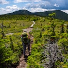
Canyonlands National Park
The largest of Utah’s national parks is also its least visited. The northern and most easily accessible part of the park, between the two rivers, is called the Island in the Sky – a mesa around 12 miles long, branching off in dozens of spindly fingers. At one fingertip is Upheaval Dome, where jagged rocks at the centre of a circular void may be evidence of a meteorite strike 60 million years ago. On one of the eastern clifftops, Mesa Arch frames a view over valleys and sculpted rocks leading down to the recesses of the Colorado River.
The Grand View Point overlook at the end of the Island in the Sky is only nine miles as the eagle flies from the Needles in the southern section of the park, but 125 miles and three hours by car. Instead of imposing mesas, the scenery here is more troglodytic, with crowds of hoodoos – columns of worn-down rock capped with more sturdy boulders that protect them.
Both here and at Horseshoe Canyon are found the remains of cultures that existed here before the Spanish and ‘Anglo’ settlers, from a stone granary built by Puebloan peoples to ochre-coloured rock art depicting ancient humans and the animals they hunted. The life-size figures in the Great Gallery at Horseshoe Canyon may be up to 4000 years old.
Get there: The Island in the Sky section of Canyonlands is around an hour’s drive from Moab along most of the same route as to get to Dead Horse Point. The Needles are a 1.5-hour drive from Moab. The western Maze section is not recommended except to very experienced 4x4 drivers, while Horseshoe Canyon can be visited with rangers on weekend hikes in spring and autumn.

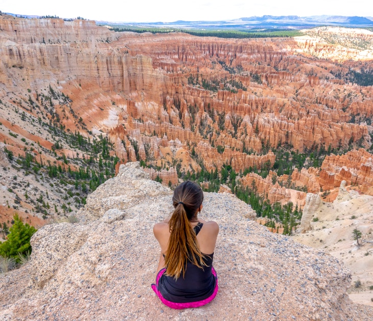
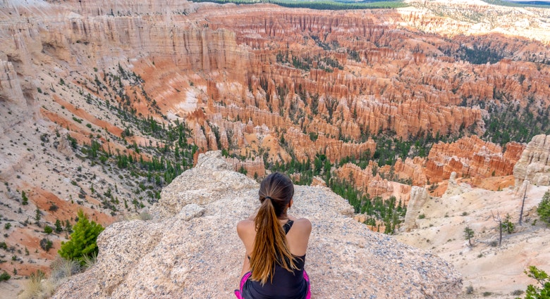
Bryce Canyon National Park
In the tales of the Paiute people of Utah, long ago there lived the To-whenan- ung-wa, or Legend People, who were animals of all kinds with the power to take on human form. They were arrogant and misused the land, so in punishment, the coyote god, known as a trickster by Native Americans, turned them all to stone. They still stand in their thousands at Bryce Canyon National Park, as the totem-pole-like rock formations known as hoodoos. Though Bryce Canyon is one of America’s smallest national parks at just 20 miles long, the concentration of sunset-coloured hoodoos creates a mesmerising effect, as often happens when a shape is repeated everywhere the eye turns to. The park is not so much a canyon as the eastern edge of a great plateau, nibbled into a series of amphitheatres at a rate of about one metre every hundred years, through layers of limestone, siltstone and mudstone that give the hoodoos their segmented appearance.
The Scottish-born Mormon pioneer Ebenezer Bryce, who gave his name to Bryce Canyon in the late 1870s, called it ‘a hell of a place to lose a cow’. Only the park’s prairie dogs are oblivious to the maze of hoodoos, creating underground labyrinths of their own.
Get there: park gateway Bryce Canyon City (population 138) is a 4.5-hour drive from Moab on Highway 191, I-70 and Highway 89.
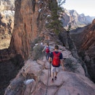
Zion National Park
Even with eyes closed, Zion National Park overawes with the names of its mountains and valleys – the Court of the Patriarchs, Tabernacle Dome, the Organ, the Pulpit and the Great White Throne. Mount Moroni bears the name of the angel who Mormons believe appeared to the founder of their church in the 1820s, and even the area’s native religions get a look-in, with the Temple of Sinawava – that trickster coyote god again.
Zion is the midway point on a descent through geological time known as the Grand Staircase. Bryce Canyon, 40 miles to the northeast, is the top step – its rocks are less than 60 million years young. The Grand Canyon, 60 miles to the south and into Arizona, cuts into the Vishnu Schist at its base, laid down two billion years ago. Many corners of Zion are rightly out of human reach, though bighorn sheep and mountain lions might tread there. Highly endangered California condors are sometimes seen soaring above the peaks. Only they know Zion’s true extent.
Get there: it’s a 1.5-hour drive, mostly south on Highway 89, from Bryce Canyon City to the east entrance of Zion National Park.