The very name evokes all that is harsh, hot and hellish – a punishing, barren and lifeless place of Old Testament severity. Yet closer inspection reveals that in Death Valley nature is indeed putting on a lively show: sensuous sand dunes, water-sculpted canyons, rocks moving across the desert floor, extinct volcanic craters, palm-shaded oases, stark mountains rising to 11,000ft and plenty of endemic wildlife.
This is a land of superlatives, holding the US records for hottest temperature (134°F/57°C), lowest point (Badwater, 282ft below sea level) and largest national park outside Alaska (more than 5300 sq miles).

Does anyone live in Death Valley?
The Timbisha Shoshone tribespeople have lived in the Panamint Range for centuries, visiting the valley every winter to gather acorns, hunt waterfowl, catch pupfish in marshes and cultivate small areas of corn, squash and beans. After the federal government created Death Valley National Monument in 1933, the tribe was forced to move several times and was eventually restricted to a 40-acre village site near Furnace Creek, where the Timbisha Shoshone still live.
In 2000 President Clinton signed an act transferring 7500 acres of land back to the Timbisha Shoshone tribe, creating the first Native American reservation inside a US national park. Today, a few dozen Timbisha live in the Indian Village near Furnace Creek. Pop by to sample the filling and tasty Timbisha Taco ($10 to $12), made with fry bread in place of a tortilla.

Highlights of Death Valley
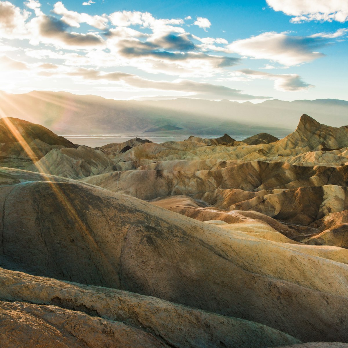
Zabriskie Point
Early morning is the best time to visit Zabriskie Point for spectacular views across ethereally glowing, golden badlands eroded into waves, pleats and gullies. The spot was named for a manager of the Pacific Coast Borax Company and also inspired the title of Michelangelo Antonio's 1970s movie. The cover of U2's Joshua Tree album was also shot here.
Mesquite Flat Sand Dunes
The most accessible dunes in Death Valley are a gracefully curving sea of sand rising up to 100ft close to the highway just east of Stovepipe Wells Village. They are at their most photogenic at sunrise or sunset when bathed in soft light and accented by long, deep shadows. Keep an eye out for animal tracks. Full-moon nights are especially magical. With luck and good hearing, you can witness the Mesquite Flat Sand Dunes emit a low humming sound when standing at the top.

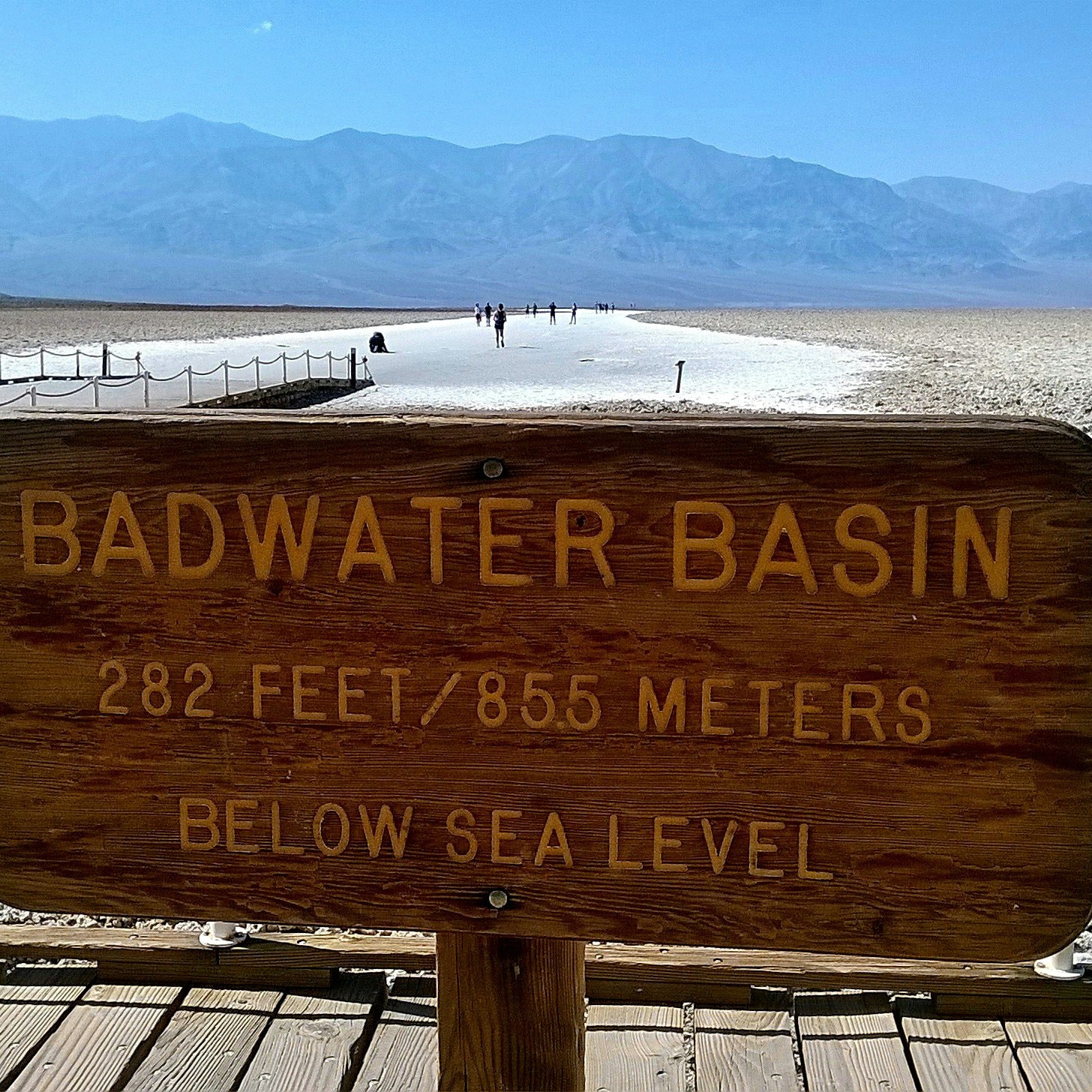
Badwater Basin
The lowest point in North America (282ft below sea level) is an eerily beautiful landscape of crinkly salt flats. A boardwalk takes you out over a constantly evaporating bed of salty, mineralized water that’s otherworldly in its beauty. It's about 17 miles south of Furnace Creek.
Dante's View
Negotiate a vertiginous mountain road to simultaneously see the lowest point and highest points in the continental US. At 5475ft, the view of the entire southern Death Valley basin from the top of the Black Mountains is absolutely brilliant, especially at sunrise or sunset. On very clear days, you can simultaneously see the highest (Mt Whitney) and lowest (Badwater) points in the contiguous USA. Allow about 1½ hours for the 26-mile round-trip drive from the turnoff at Hwy 190, east of Furnace Creek.

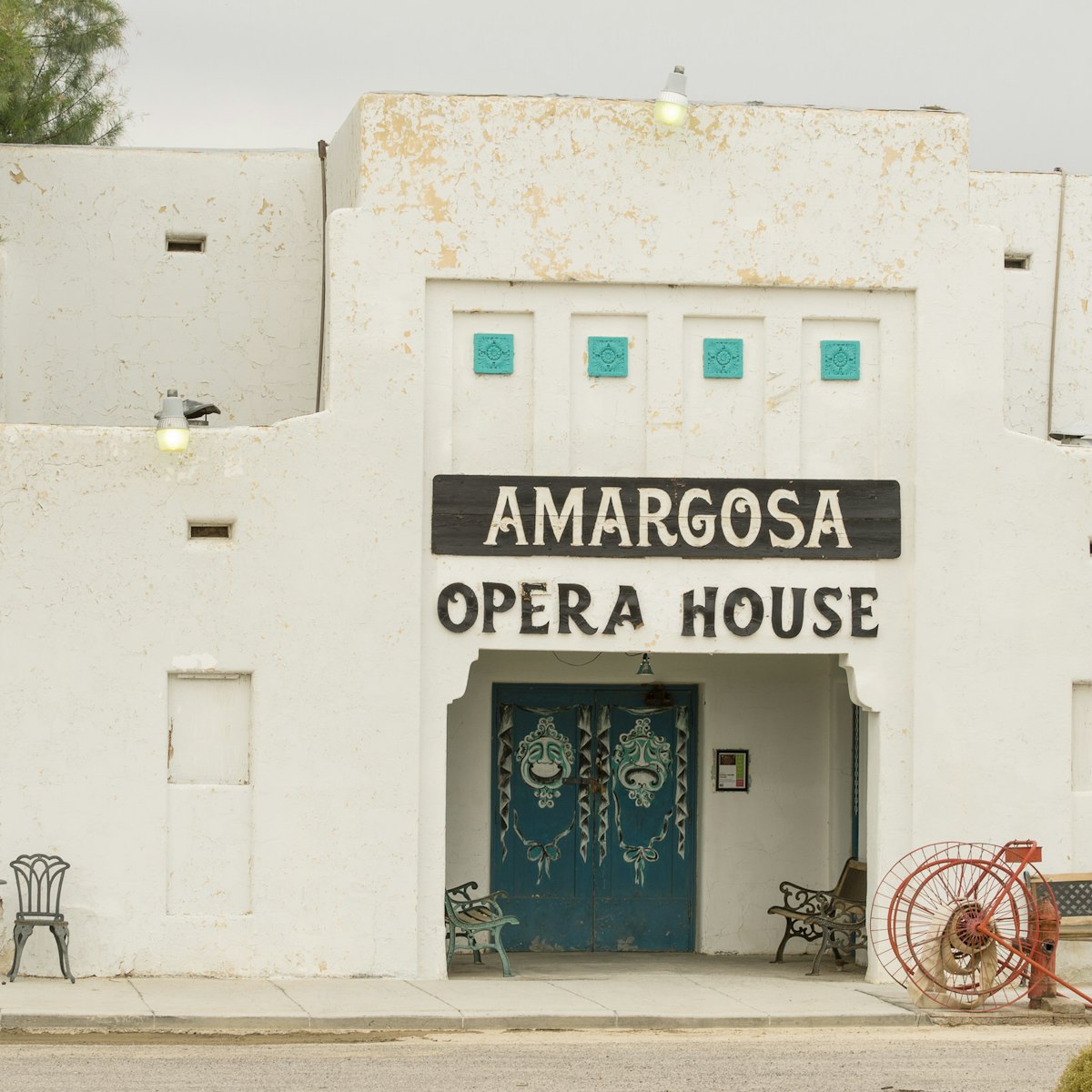
Amargosa Opera House
The Timbisha aren't the only ones who have called Death Valley home. New York dancer Marta Beckett fell in love with a 1920s colonnaded adobe building when her car broke down in Death Valley Junction in 1967. Until her death at age 92 in 2017, she entertained the curious with dance, music and mime shows at the Amargosa Opera House. Visiting performers, inspired by Marta, continue to keep her legacy alive in fall and winter. A simple roadside memorial stone honors the accomplishments of this intrepid woman.
Artists Drive
About 10 miles south of Furnace Creek is the turn-off for Artists Drive, which offers 'wow' moments around every turn. About 5 miles in, you'll pass the main stop called Artists Palette, where oxidized metals tinge the mountains into hues from rose to green and purple; view them at their luminous best right before sunset. The road is well paved but windy with the occasional fun rollercoaster-style dip, and is nine miles one way.

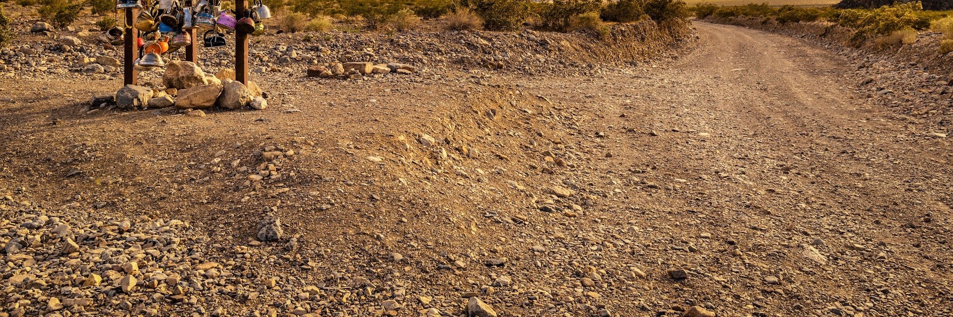
Racetrack Playa
Beyond the northern end of Hwy 190, it's slow going for 27 miles on a tire-shredding dirt road (high-clearance and 4WD usually required) to the lonesome Racetrack Playa. Here, hundreds of sizeable rocks have etched tracks into the dry lake bed. In 2014, a group of researchers finally lifted the mystery when they observed the stones being pushed by winds across thin sheets of ice that had formed overnight. Read all about it at www.racetrackplaya.org.
Ryholite
Rhyolite epitomizes the hurly-burly, boom-and-bust story of Western gold-rush mining towns. After the first nugget was discovered in 1904, the population soared to 8000 by 1908, only to plummet a couple of years later when the mines began petering out. The remaining ruins, including a school, store, bank and railway station, reflect the high standard of living created for such a short period. A much photographed curiosity is a house made of thousands of beer bottles.

Death Valley Weather
Death Valley is sunny, dry and clear year-round, but don't assume it's always hot: temperatures fluctuate hugely, from 38°F/3°C in December to 116°F/43°C in July. Dress accordingly.
Peak visiting seasons are winter and the springtime wildflower bloom. In summer, a car with reliable air-con is essential and outdoor explorations in the valley should be limited to the early morning and late afternoon. Escape the heat by heading to the mountains. Winter rains are a possibility and flash flood damage or snow in the mountains regularly leads to road closures.

Hiking
The best time for hiking is November to March. Stay off the trail in summer, except on higher-elevation mountain trails, which are usually snowed in during winter. Constructed paths are rare in Death Valley and all but the easiest hikes may require some scrambling or bouldering. An adequate water supply is essential; one gallon per day per person in summer and half a gallon in winter are recommended.
Golden Canyon
Whether a short stroll or strenuous trek – don't miss a spin around this winding wonderland of golden canyons between Badwater Rd and Zabriskie Point. The most popular route is a 3-mile in-and-back trek from the main trailhead off Badwater Rd to the oxidized iron cliffs of Red Cathedral. Combining it with the Gower Gulch Loop adds another mile. Alternatively, kick off at Zabriskie Point for the 2.7-mile Badlands Loop.

Mosaic Canyon Trail
West of Stovepipe Wells Village, a 2.3-mile gravel road deadends at the mouth of Mosaic Canyon, from where a 4-mile in-and-out trail meanders past polished marble walls carved from 750 million-year-old rocks. About 0.25 miles past the trailhead, the canyon narrows dramatically; about 1.3 miles in, a pile of boulders blocks the passage but it's possible to squeeze by on the left and continue the trek.
Telescope Peak
The park’s highest summit is Telescope Peak (11,049ft), with views that plummet to the desert floor, which is as far below as two Grand Canyons deep! The 14-mile round-trip trail clocks a 3000ft elevation gain from its trailhead at the Mahogany Flat campground. Summiting in winter requires an ice-axe, crampons and winter-hiking experience. By June, the trail is usually free of snow.
Wildrose Peak
This 8.4-mile round-trip hike with a sweat-inducing 2200ft elevation gain begins near the charcoal kilns off Wildrose Canyon Rd and threads past piñon pines and juniper to a lofty 9064ft. Grand views of the Panamint Valley, Badwater Basin and all of Death Valley National Park starting about halfway. It's best in spring or fall.The final mile below the summit is the toughest stretch.

Visiting Death Valley National Park
Park entry permits ($30 per vehicle) are valid for seven days and available from self-service pay stations along the park's access roads and at the visitor center. Cell towers provide service at Furnace Creek and Stovepipe Wells Village but there's little to no coverage elsewhere in the park.
The park's main roads (Hwys 178 and 190) are paved and in great shape, but if your travel plans include dirt roads, a high-clearance vehicle and off-road tires are highly recommended and essential on many routes. 4WD is often necessary after rains. Always check with the visitor center for current road conditions, especially before heading to remote areas.

Furnace Creek
Furnace Creek is Death Valley’s commercial hub, home to the national park visitor center, a gas station, ATM, post office and lodging. There's also a Mission–style 'town square' with a general store, restaurant, saloon and ice cream and coffee parlor. Facilities at Stovepipe Wells Village and Panamint Springs also include gas, food and lodging.
Gas is available 24/7 at Furnace Creek and Stovepipe Wells Village and from 7am to 9:30pm in Panamint Springs. Prices are much higher than outside the park.
Beatty
Around 40 miles north of Furnace Creek, the historic mining town of Beatty (population 1000) across the Nevada border has certainly seen better days but makes a less-expensive launchpad for visiting Death Valley. It also has an ATM, gas station and a general store.

Shoshone
On the southern stoop of Death Valley, about 60 miles from Furnace Creek, blink-and-you-miss-it Shoshone stakes its existence on being an early-20th-century railroad stop. The railroad disappeared in 1941, but the village still caters to travelers with a gas station, general store, restaurant, lodging and small tourist office.
Tecopa
The old mining town of Tecopa was named after a peacemaking Paiute chief. Its desolate looks belie an artistic undercurrent and an unexpected number of fun spots. Soak in hot natural mineral springs, explore a hidden date-palm oasis, fuel up at excellent restaurants and get toasted at not one, but two craft breweries. It's about 70 miles from here to Furnace Creek.

Death Valley hotels
In-park lodging options that aren't a tent are limited, pricey and often fully booked in springtime. Alternative bases are the gateway towns of Beatty (40 miles from Furnace Creek), Lone Pine (40 miles), Death Valley Junction (30 miles), Shoshone (60 miles) and Tecopa (70 miles). Options a bit further afield include Ridgecrest (120 miles) and Las Vegas (140 miles).
That said, there are two especially well-regarded options, one in the park proper and the other in Death Valley Junction.
The Oasis at Death Valley
The Oasis at Death Valley is so well located you can roll out of bed, pull back the curtains and count the colors of the desert. This 1927 Spanish Mission–style hotel is brimming with all the expected 21st-century comforts. After a day of sweaty touring, languid valley views await as you relax by the spring-fed swimming pool with a spa and pool bar, in the warmly furnished lounge or in the library. A class act throughout.
The Amargosa Hotel
Meanwhile, adjacent to the Amargosa Opera House is the Amargosa Hotel. With no TV or wi-fi, sunsets and starry skies are the only nighttime entertainment provided by the 16-room lodge built in 1925 by the Pacific Coast Borax Company. Today, the vintage gem delivers buckets of kookiness thanks to eccentric staff, muraled rooms and a resident ghost or two.
New mattresses have raised comfort levels, and all guests are welcome to use the communal kitchenette – bring supplies as there is no store. The attached farm-to-table cafe serves scrumptious breakfasts, strong coffee and healthy sandwiches but has limited hours.

Camping near Death Valley
The National Park Service operates nine campgrounds, including four tucked into the Panamint Mountains. Only Furnace Creek accepts reservations and only from mid-October to mid-April. All other campgrounds are first-come, first-served. At peak times, such as weekends during the spring wildflower bloom, campsites fill by midmorning. On those days, vast Sunset campground is your best bet for snagging a last-minute spot, plus there's always the option of free backcountry camping.
Backcountry camping is allowed along dirt roads at least 1 mile away from paved roads and developed and day-use areas, and 100yd from any water source, and no fires are allowed. Park your car next to the roadway and pitch your tent on a previously used campsite to minimize your impact. For a list of areas that are off-limits to backcountry camping, as well as additional regulations, check the official National Parks Service website or stop by the visitor center where you can also pick up a free voluntary permit.
Private campgrounds catering mostly to RVers can be found in Furnace Creek, Stovepipe Wells Village and Panamint Springs. Stovepipe Wells Village offers public showers ($5, including swimming-pool access). Pay at reception. Mesquite Springs Campground and Thorndike Campground are two other popular options.