Arkansas abounds with excellent hiking options.
The state’s natural beauty astounds, from mountain ranges clad in oak, maple, hawthorn and short-leaf pine, to stunning river valleys where you can legitimately feel as if you’ve dropped out of civilization. Hikes here run the full gamut from easy out-and-back adventures to potential multi-day excursions. Note that summer weather can get sweltering, although higher altitudes and shade are present in most mountain hikes. Ticks are fairly common (although Lyme disease numbers are low), so make sure to wear a hat and, weather permitting, long sleeves and pants.
From hikes in the Ozarks to hikes to waterfalls, here are the best hiking options in Arkansas.
Mt Nebo Rim Trail offers the best mountain views
3.5-mile loop (5.6km); 2–3 hours, moderate
Rising 1350ft (410m) above Lake Dardanelle and the Arkansas River, Mt Nebo is a commanding natural presence in a state with no shortage of dramatic scenery. To this end, the summit offers unparalleled views of the Arkansas River Valley in almost all directions (at the top, you’ll find both a Sunrise Point and a Sunset Point). The mountain and all of the trails that crisscross it are part of Mt Nebo State Park, first built by the Civilian Conservation Corps (CCC) in 1935.
There are intense, high-grade scrambles and step-heavy hikes that go up Mt Nebo, but all levels of outdoors experience can access the Rim Trail. Actually finishing this loop requires a little more endurance. We rate this hike as moderate, simply because that is the median between easy stretches and tough climbs with steep stone steps, both present here.
You can get to the Rim Trail via a stairway behind the park visitor center. If you’re with kids or very casual hikers, note that the trail is easier heading left from the bottom of the stairs, while the area to the right has the steepest, rockiest sections.
To get to Mt Nebo State Park and the visitor center, take Hwy 155 near Dardanelle, AR. Note that the road up Mt Nebo is as twisty as a scribble, and steep to boot.
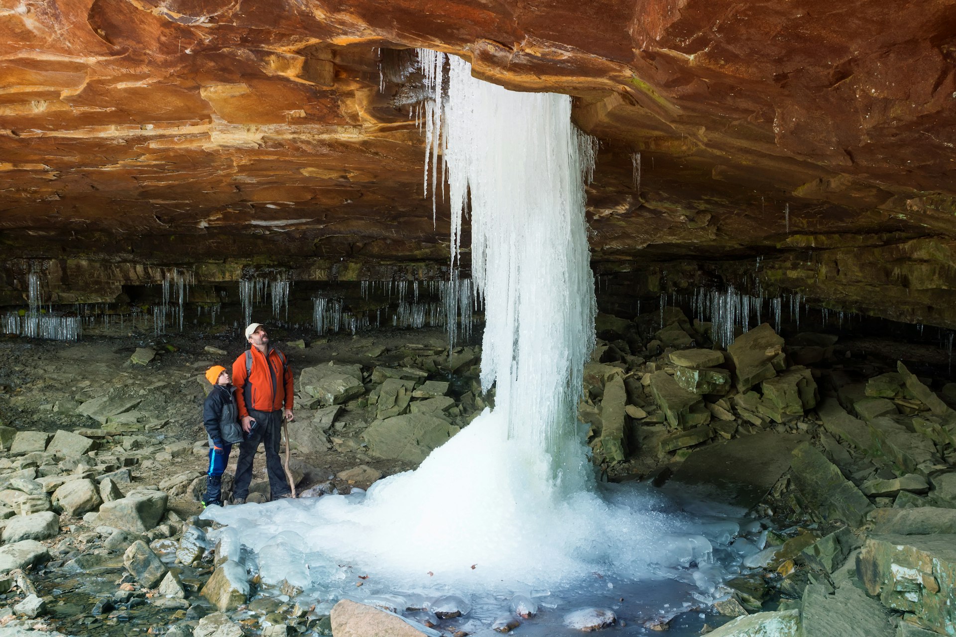
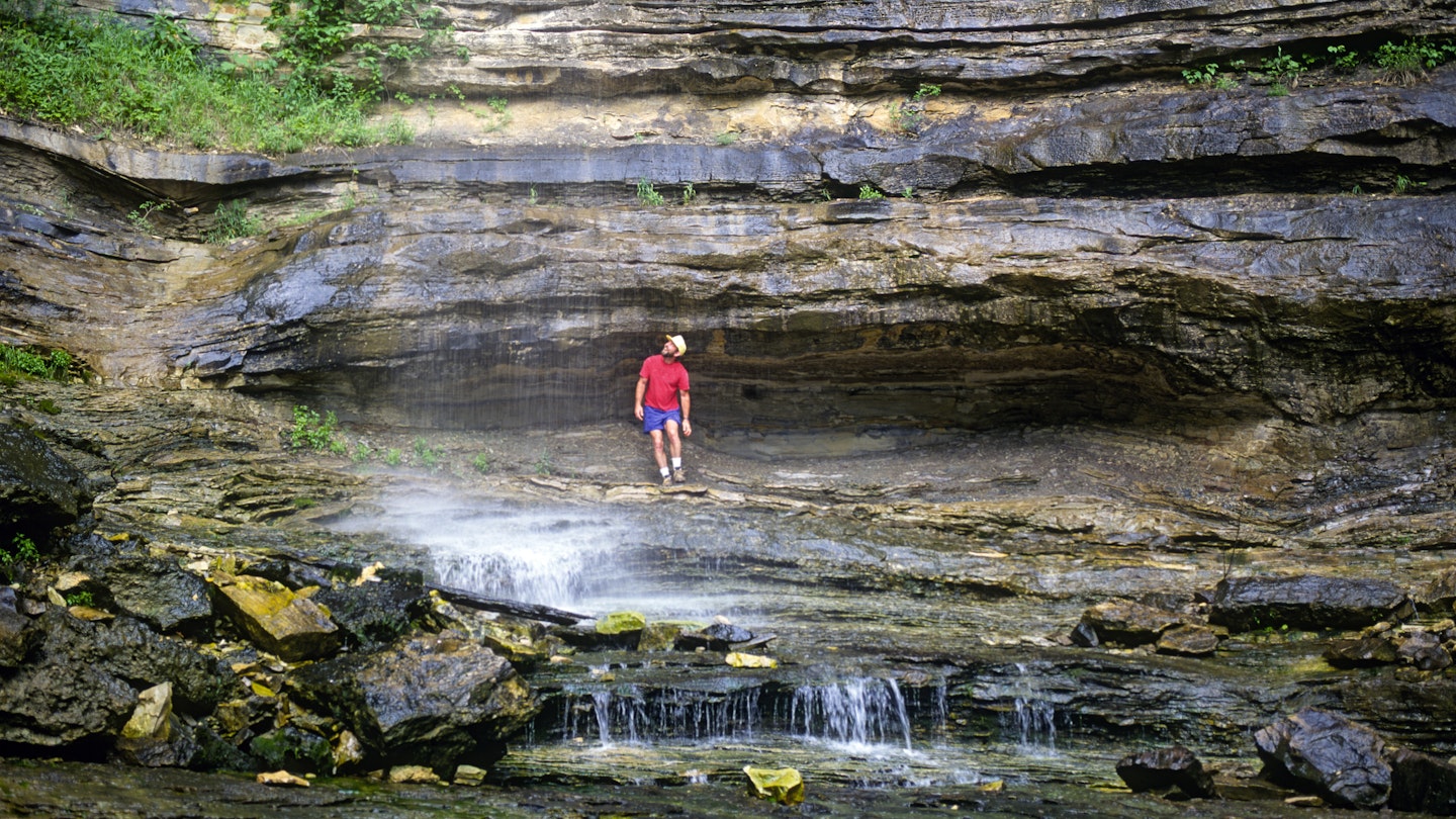
Glory Hole Waterfall Trail is a wonderfully unique waterfall trail
1.9 miles (3.05km) roundtrip; 1–1.5 hours; easy
Glory Hole gets its...memorable name from a stream that flows through a hole in an overhanging bluff. The result is a uniquely beautiful geographic oddity. In some seasons, the water flow is merely a trickle, but during a wet spring (or after any big rainfall) it looks like a full river is getting squeezed through the rock face. Come here in the depths of a cold winter and you may see a column of ice connecting the bluff to the ground below.
The trailhead for the falls is located off of AR-16/21, about 6 miles east of Fallsville. On the south side of the highway you’ll find a small pull-off parking area along with a sign indicating the trailhead. Follow the trail for about half a mile, at which point you’ll cross Dismal Creek, which feeds the falls.
There is a steep clamber down here, and the rocks can be slippery; proceed with caution. If you see small cascades running down rock faces along the way, that’s a good indicator of the size of the water flow to come. Note that the steep slope down to the falls is the most difficult part of the hike; it’s not so bad on the way down, but hits harder on the way out.
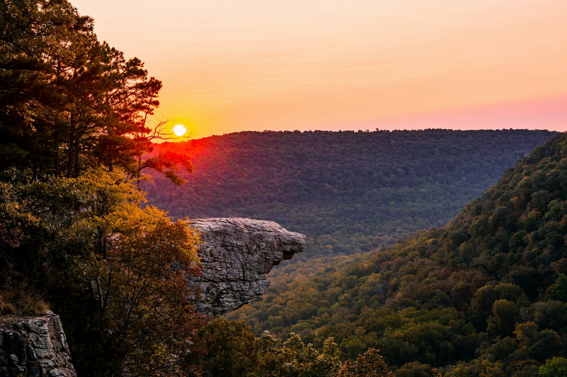
Hawksbill Crag offers the state’s most iconic overlook
3 miles (4.8km) out and back; 1.5 hours; moderate
Jutting out over the Upper Buffalo Wilderness like a rocky dagger, Hawksbill Crag may be the most photographed outdoor destination in Arkansas. Get up here with the wind at your back and the forested mountains of Northwest Arkansas in front of you, and you’d be forgiven for letting loose a mighty holler.
The trail out to Hawksbill Crag is also known as the Whitaker Point Trail. It’s not very long, but there is some decent elevation gain along the way (400 ft/122m) and some steep bluffs to contend with. During the wetter spring months you may spot some cascades along the rocks; we recommend trying this trail in the autumn, when you’ll have excellent sight lines out over the leafy canopy for much of this trail, plus the Whitaker Valley at the end. When the foliage changes, the views are heartachingly beautiful.
This is a popular trail all year long, so expect to encounter other hikers. The closest sizable town is Ponca, about 13 miles to the north. From there, take AR-43 to County Rd 5, which you can follow to a parking area and trailhead. Said parking area is small; if the weather is nice, expect to park a little ways up the road.
Hemmed-in Hollow is an ideal full-day hike
5 miles (4.8km) out and back; 4–5 hours; challenging
In the heart of the Ozarks, Hemmed-in Hollow is not a great hike for beginners, kids or anyone who is generally feeling out of shape: you can expect about 2.5 miles of steady and often steep elevation gain. The terrain, while lovely, can be slick (on the rocks) or slurry (in the mud), especially after the rains, and the trailhead can be a bear to find.
But hike out here and – beyond the usual wonderful scenery – you’ll find a box canyon that feels like an entrance to a fantasy world. This geographical oddity is a 200-foot tall waterfall, the tallest in the United States between the Rockies and Appalachians. One of the main difficulties of the hike is getting from the trail area down to the falls; know that you are going to have to contend with serious slopes and switchbacks.
To get here, take AR-43 from Ponca, then around Compton take Co Rd 19 into the woods. Keep an eye out for signs that either point to a “Wilderness Area” or a trailhead marker. Hemmed-in Hollow may be one of the state’s more challenging hikes, but it is extremely popular, so expect to run into friends.
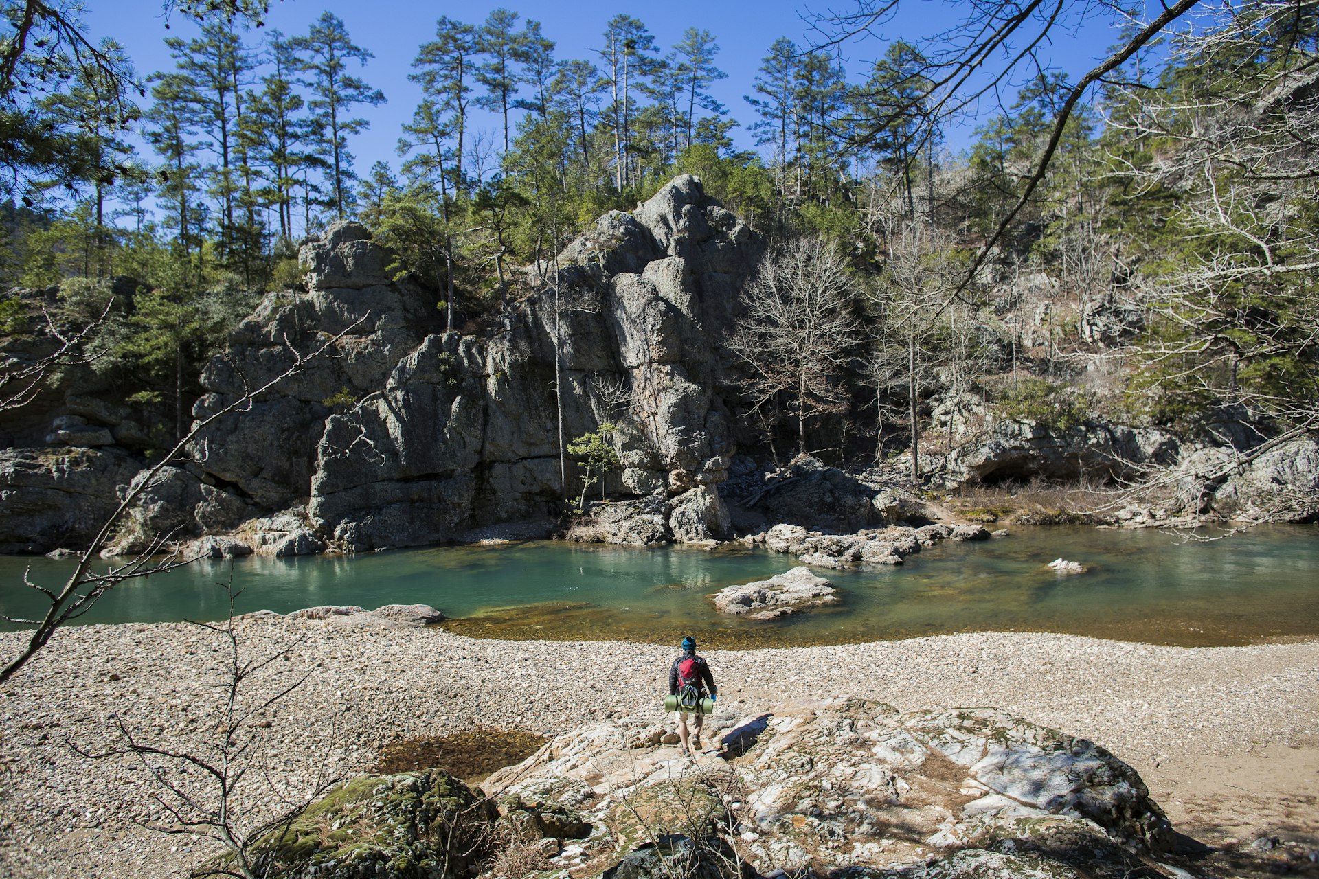
For the best multi-day hike, hit the Eagle Rock Loop
26.5 miles (42.6km); multiple days; challenging
Located in Ouachita National Forest, the Eagle Rock Loop is Arkansas’s most iconic “big” hike – the sort of trek people spend a few days (usually three for experienced hikers) completing. This hike truly checks all the boxes on the Arkansas outdoors bucket list: green pine and deciduous forest, smooth rock bluffs, jagged uplands, some 4000ft (1200m) of elevation gain and nine creeks to cross. (The US Forest Service warns that one ford over the Little Missouri River can expand to some 150ft/45m.) The loop can be accessed from multiple points within the National Forest, and encloses much of the Brier Creek Mountains.
The Eagle Rock Loop follows a 100-year old postal route and wagon trail, but don’t expect any kind of surfacing along the way. Cell-phone reception isn’t great either, so make sure you have a map of the trail already on hand/downloaded. There are primitive campsites spaced along the loop and numerous water sources, although all water will need to be treated.
Call the Forest Service before attempting the hike to get a read on possible dangerous conditions, particularly water crossings. All of that said, anyone who finishes the Eagle Rock Loop can rightfully claim they have completed one of the Natural State’s most rigorous natural activities.
You might also like:
There’s adventure for every terrain in Arkansas
Glamping in Arkansas puts you in the middle of the action
I’ve been everywhere (at least in Arkansas and Tennessee): A Johnny Cash road trip