This fabulous archaeological zone lies in a mountain-ringed offshoot of the Valle de México. Site of the huge Pirámides del Sol y de la Luna (Pyramids of the Sun and Moon), Teotihuacán was Mexico's biggest ancient city and the capital of what was probably the country's largest pre-Hispanic empire.
The pyramids
The site's main drag is the famous Calzada de los Muertos, a monumental avenue lined with the former palaces of Teotihuacán's elite. To its south is the pyramid-bedecked La Ciudadela, believed to have been the residence of the city's supreme ruler. Enclosed within the citadel's walls is the Templo de Quetzalcóatl, with its striking serpent carvings.
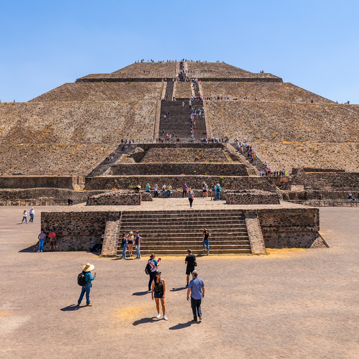
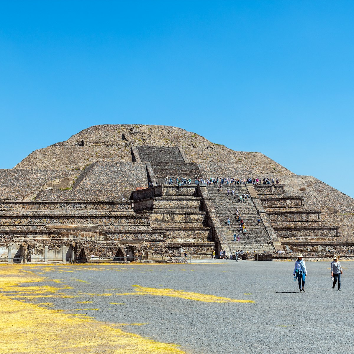
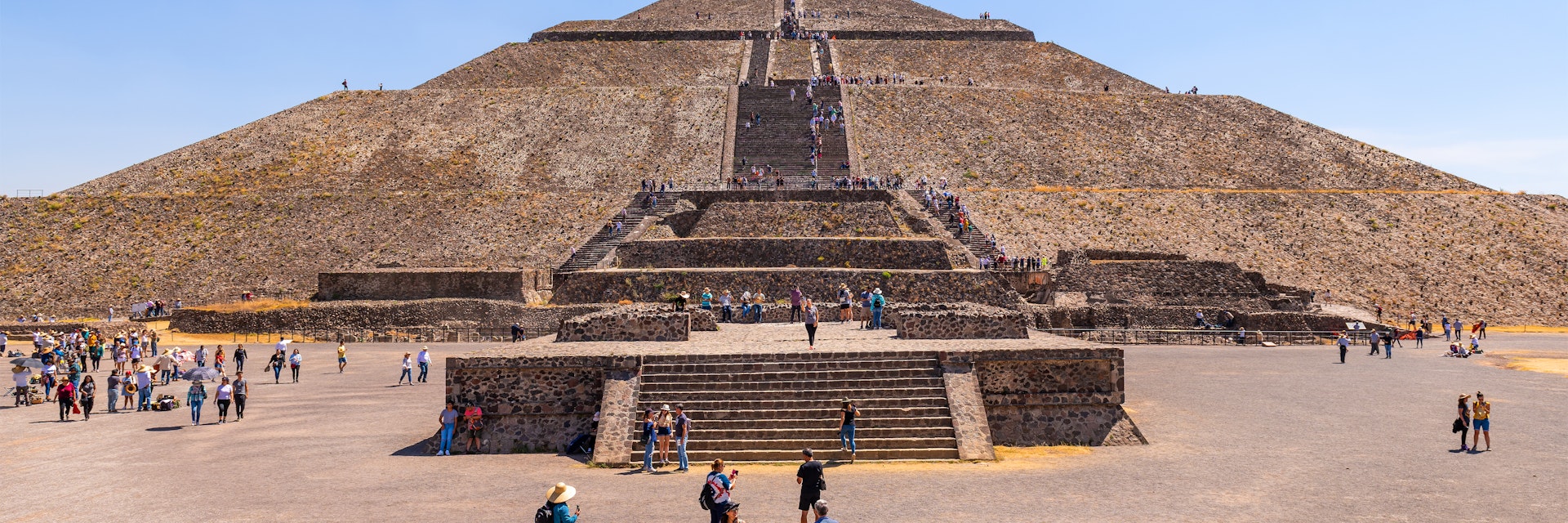
Heading north, you pass the world's third-largest pyramid: the awe-inspiring, 230ft (70m), 248-stepped Pirámide del Sol. The avenue terminates at the Pirámide de la Luna, flanked by the 12 temple platforms of the Plaza de la Luna. Nearby are the beautifully frescoed Palacio de Quetzalpapálotl (Palace of the Quetzal Butterfly), the Palacio de los Jaguares (Jaguar Palace) and the Templo de los Caracoles Emplumados (Temple of the Plumed Conch Shells). Teotihuacán's most famous mural, the Paradise of Tláloc, is in the Palacio de Tepantitla, northeast of the Pirámide del Sol. There's an onsite museum to help make sense of it all.

History
Teotihuacán was a major hub of migration for people from the south, with multi-ethnic groups segregated into neighborhoods. Studies involving DNA tests in 2015 theorize that it was these cultural and class tensions that led to Teotihuacán's downfall.
The city’s grid plan was plotted in the early part of the 1st century CE, and the Pirámide del Sol was completed – over an earlier cave shrine – by 150 CE. The rest of the city was developed between about 250 and 600 CE. Social, environmental and economic factors hastened its decline and eventual collapse in the 8th century.
The city was divided into quarters by two great avenues that met near La Ciudadela (the Citadel). One of them, running roughly north–south, is the famous Calzada de los Muertos (Avenue of the Dead), so called because the later Aztec believed the great buildings lining it were vast tombs, built by giants for Teotihuacán’s first rulers. The major structures are typified by a talud-tablero style, in which the rising portions of stepped, pyramid-like buildings consist of both talud (sloping) and tablero (upright) sections. They were often covered in lime and colorfully painted. Most of the city was made up of residential compounds, some of which contained elegant frescoes.
Centuries after its fall, Teotihuacán remained a pilgrimage site for Aztec royalty, who believed that all of the gods had sacrificed themselves here to start the sun moving at the beginning of the ‘fifth world,’ inhabited by the Aztec themselves. It remains an important pilgrimage site: thousands of New Age devotees flock here each year to celebrate the vernal equinox (between March 19 and March 21) and to soak up the mystical energies believed to converge here.
Tickets and information
Tickets can be bought on the day at the entrance for M$75. If you're part of a group tour, your ticket will be included and you won't need to queue up. A day here can be awesome – don't let the hawkers get you down. Bring a hat, water and your walking shoes. The guardabultos (lockers) can store medium-sized bags.
How do I get there?
Teotihuacán is located 31 miles (50km) northeast of Mexico City. If you want to start early at the site before the crowds arrive and don't want to take a dawn tour, the town of San Juan Teotihuacán, just over a mile (2km) from the archaeological zone, has a few good overnight options, though there is little life around.
During daylight hours, Autobuses México–San Juan Teotihuacán runs buses from Mexico City’s Terminal Norte to the ruins (M$52, one hour) every hour from 7am to 6pm. When entering Terminal Norte, turn left to gate 8 for tickets, though ask which gate your bus departs from. Make sure your bus is headed for ‘Los Pirámides,’ not the nearby town of San Juan Teotihuacán (unless you are heading to accommodations in San Juan). Armed robberies still occasionally occur on these buses; for current warnings, search the US State Department website for 'Teotihuacán.'
At the ruins, buses arrive and depart from near gate 1, also making stops at gates 2 and 3 via the ring road around the site. Your ticket allows you to re-enter through any of the five entrances on the same day. The site museum is just inside the main east entrance (gate 5).
Return buses are more frequent after 1pm. The last bus back to Mexico City leaves at 6pm; some terminate at Indios Verdes metro station, but most continue to Terminal Norte.
Alternatively, tours to the ruins are plentiful, are better value for solo travelers than renting a guide alone, and depart conveniently from Mexico City's Zócalo metro station or accommodations. Capital Bus and Turibús run daily minivan tours including a bilingual guide and entrance fee, with or without a visit to the Basílica de Guadalupe. Reservations are required.
Top tips
- Exploring the Teotihuacán site is fascinating, but rebuffing the indefatigable hawkers is exhausting. Crowds at the ruins can be huge. They're thickest from 10am to 2pm, and are busiest on Sunday, holidays and around the vernal equinox; going early pays off.
- Due to the heat and altitude, it’s best to take it easy while exploring the expansive ruins. Bring a hat and water – most visitors walk at least several miles, and the midday sun can be brutal. Afternoon rain showers are common from June to September.
- English speaking guides are available at the gates for about M$600 per group. An organized tour with guide from Mexico City can be a better-value option if you are traveling solo or in a very small group.